The Human Footprint
Here’s a question. When a major natural disaster strikes — for example, in Myanmar (Burma) earlier this year — how does the world figure out how many people are affected?
Here’s the answer: they ask SEDAC — NASA’s Socioeconomic Data and Applications Center — which works with GRUMP.

No, not that GRUMP; the Global Rural-Urban Mapping Project (GRUMP) provides estimates of the population of the world and population densities, which are then overlayed with other scientific data to provide detailed maps of everything from ecosystem assessments to — wait for it — the global poultry density.
And, of course, the number of people affected when disaster strikes:
“The gridded population product we produce helps officials understand the density of the population in and around a disaster area,” said Robert Chen, manager of NASA’s Socioeconomic Data and Applications Center (SEDAC) and director of the Center for International Earth Science Information Network (CIESIN), part of the Earth Institute at Columbia University in New York. “The data set shows where people actually live in relationship to hazardous events….
SEDAC, a part of NASA’s Earth Observing System Data and Information System, collects, stores, processes and distributes population, land use, and socioeconomic data. A significant mission of NASA’s Earth-observing satellite program is to enable scientists and other users to conduct analyses and make decisions based on the resulting data. SEDAC advances this mission by developing and operating practical applications that merge social science and Earth science data to improve knowledge of how humans interact with Earth’s environment.
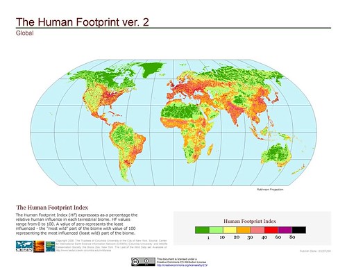
The dataset produced by GRUMP is fascinating. Think you live in a crowded area? Take a look at India and China. SEDAC has also produced an amazing series of maps showing the "human footprint" on the world, which can be viewed here.
Also be sure to check out CIESIN’s maps showing the global distribution of vulnerability to climate change.