“Breakthrough” Map of Antarctica
When we blogged about the Vanco Arctic Survey—a detailed survey about the health of the North Pole cap in a climate of rapid melting—we had no idea that we’re in the middle of the International Polar Year. In that spirit, let’s head south and check-in on Antarctica:
The Landsat Image Mosaic of Antarctica (LIMA) brings "the coldest continent on Earth alive in greater detail than ever before through [a] virtually cloudless, seamless, and high resolution satellite view of Antarctica." According to NASA, by piecing together more than a thousand images from three years of Landsat satellite observations, the new map provides a realistic look at the continent in 10 times greater detail than ever before and offers the most geographically accurate, true-color, and high-resolution views of the continent possible." NASA is so excited that they argue the map will "revolutionize research of the continent’s frozen landscape."
These four frames show the evolution from the old imagery (MODIS) to the new (LIMA):

You can view the interactive image here.
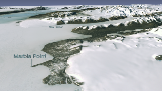
Pan to view the continent and zoom in to see the stunning detail of this Natural-Color, Pan-Sharpened LIMA (bands 3, 2, 1). LIMA covers the entire continent except from the South Pole at 90 degrees south to 82.5 degrees south latitude, where Landsat has no coverage because of its near-polar orbit. To provide a continental view, the image above has LIMA 3, 2, 1 overlaying the MODIS Mosaic of Antarctica (MOA).
The opening view includes McMurdo Station, the largest research base in Antarctica. Located at the tip of Hut Point Peninsula on Ross Island, McMurdo has been continually operated by the United States of America since 1956. Ross Island is roughly 45 miles across. The flat, white areas are the Ross Ice Shelf and other sea ice off the coast of Antarctica. Also visible are the Erebus Glacier Tongue, Koettlitz and Ferrar Glaciers, and the Royal Society Range.
If your browser is giving you troubles, download the poster to view an overview map and detailed, up-close panels. Or, better yet, watch the pretty amazing HD fly-over videos that are available here.