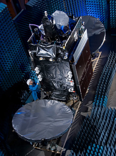
A rocket carrying a satellite used for communication by the United States Air Force lifted off Wednesday night.
The Atlas V, which launched at 8:22 p.m. (0022 Thursday), is carrying a Wideband Global SATCOM satellite. It is the first of at least five satellites that will be placed in orbit through 2008.
The system will replace the current Defense Satellite Communications System that has been used for military communications for the last two decades. This first satellite will cover the Pacific Zone which includes Hawaii, Japan and Southeast Asia. Each spacecraft will cost $350 million (€247.42 million).
The DSCS system will be used in conjunction with WGS until being phased out within the next few years.
Col. David Urich, the Military Satellite Communications Systems Wing vice commander, said the first spacecraft alone "will provide more capacity than all the current DSCS satellites currently in use."
The launch was scheduled for Tuesday, but delayed a day as engineers checked data that might have indicated the Atlas V rocket would have fallen short of its intended orbit.
Taking a look (and translating) the Proton launch manifest, we see that the Sirius 4 satellite (pictured above) is set to lift later this month, pending review of the causes behind the launch failure of the JCSAT 11 satellite from Baikonur:
SIRIUS 4 is a multi-mission Ku/Ka-band satellite. It is built on Lockheed Martin’s reliable A2100AX platform. SIRIUS 4 will be deployed at orbital position 5 degrees East.
SIRIUS 4 will be the biggest satellite and a welcome addition to the SIRIUS satellite fleet. The satellite is intended to meet today’s growing demands and tomorrow’s new challenges. SIRIUS 4 will enhance capacity and widen the coverage of Eastern Europe.
Following Sirius 4 on successive Proton launches will be Telenor’s THOR 5 bird, which has 24 transponders with three times more payload power compared to the current THOR II satellite that it replaces, as well as the AMERICOM-14 satellite.
Sirius is in competition with Telenor for not only the Scandinavian market (where the Thor 5 delay may be impacting the introduction of a new children’s channel, NRK Super) but for Central and Eastern Europe as well.
THOR 6 will be based on Thales Alenia Space Spacebus 4000B2 platform and fitted with 36 active Ku-band transponders. 16 transponders will point to the Nordic countries, and 20 transponders will be positioned to serve the growing broadcasting demands within Central and Eastern Europe. With the launch of THOR 6, the 1° West will have a total of 71 transponders providing capacity to facilitate both organic growth and expansion for Telenor.
They’ll be up early in Sydney, Australia, on Saturday morning, watching a rocket launch their new satellite — and the same goes for Intelsat in Pembroke, Bermuda, too.
For the past few weeks, Orbital Sciences has been very busy at Europe’s Spaceport in Kourou preparing for their "double-header:" they built both "passengers" set to be carried by Arianespace. Looks like a "go" for an Ariane 5 (GS configuration) launching Optus D2 and Intelsat 11 on Friday, 5 October 2007:
Arianespace’s fourth mission of 2007 is set for Friday, October 5, with the green light given today after the launch readiness review at Europe’s Spaceport.
This review, which is held before every Ariane flight, verifies the readiness of the Ariane 5 vehicle, its two payloads, the launch infrastructure at the Spaceport in French Guiana, and the downrange network of tracking stations.
The upcoming mission will orbit two medium-sized satellites built by the same U.S. manufacturer, Virginia-based Orbital Sciences Corporation, for Intelsat and Optus.
The Intelsat 11 spacecraft is riding in Ariane 5’s upper payload position, and is to be released first in the mission sequence. To be operated by Washington, D.C.-headquartered Intelsat, the satellite will host Latin America’s premiere video programmers and the region’s largest DTH (direct-to-home) platform. Intelsat 11 is based on the Orbital Sciences STAR 2 spacecraft bus, and carries a hybrid payload composed of 16 C-band and 18 Ku-band transponders. The satellite weighs approximately 2,500 kg. at launch.
Optus D2 also uses an Orbital Sciences STAR 2 bus, and is to be operated by Australian-based Optus to enable the development of new business opportunities for the direct-to-home market, new data services and services bundling. Positioned at an orbital slot of 152 deg. East, the 2,350-kg.
45-minute launch window opening, by city:
GMT: 21:28 on 5 OCT 2007
Luxembourg: 23:28 on 5 OCT 2007
New York: 17:28 on 5 OCT 2007
Kourou, French Guiana (local time): 18:28 on 5 OCT 2007
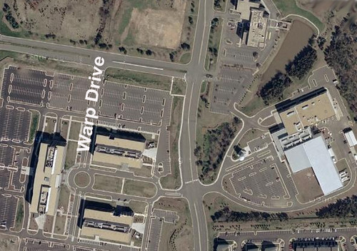
We blogged about getting a space job before, but now it looks like a few hundred can call their new business address "Warp Drive." That’s right: Warp Drive is an "inside" street name on the corporate campus Orbital Sciences, a company that’s about to expand in Northern Virginia, according to the Washington Post:
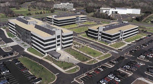
Orbital Sciences, a rocket and space technology manufacturer for the government and military, is embarking on a major expansion of its headquarters in Dulles, adding as many as four buildings and about 600 jobs to its campus.
The company’s 77-acre campus along Route 28 employs 1,500 workers. More than 100 employees work at leased office space a few miles down the road, and Orbital continues to grow. To date, the company said it has $4 billion worth of backlogged contracts.
"Orbital’s business is doing extremely well and growing quite rapidly," said Barron Beneski, a company spokesman.
The buildings — totaling 140,000 square feet — will house office, engineering and manufacturing space on an undeveloped tract of land adjacent to the campus. Construction on the first building has been approved by Loudoun County and is scheduled to begin in early 2008. The first new employees could occupy the space in 2009.
"The next several years we will build buildings as the need arises," Beneski said.
The federal government is Orbital Sciences’ biggest customer. The satellite company has contracts with the Defense Department and military intelligence agencies.
Space flight, in particular, is fueling much of Orbital Sciences’ growth, Beneski said. In 2010 NASA plans to retire the Space Shuttle. The company is part of a team led by Lockheed Martin that is producing the next generation of manned spacecraft to launch astronauts to the moon and beyond. The company stands to make $450 million to $500 million over the next 12 years from its role in the program.
Orbital also manufactures commercial communication satellites for companies such as Intelsat and SES Global. "In the Washington area, there’s not a whole lot of manufacturing going on," Beneski said. "Consultants and IT people produce a lot of paper and gigabytes. We actually produce real stuff."
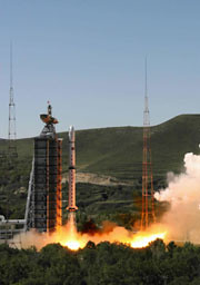
CBERS-2B é lançado com sucesso da base chinesa de Taiyuan
Exatamente às 00h26min desta quarta-feira (19) foi lançado com sucesso o CBERS-2B, terceiro satélite da parceria entre Brasil e China. O evento foi comemorado tanto no Centro de Controle de Satélites do INPE, em São José dos Campos (SP), como no Centro de Lançamento de Satélites de Taiyuan. O diretor do INPE, Gilberto Câmara, assistiu ao lançamento na base chinesa e, junto com os engenheiros Ricardo Cartaxo e Jânio Kono, respectivamente coordenador geral e coordenador do Segmento Espacial do Programa CBERS, transmitiu todas as informações aos técnicos e convidados que acompanharam da sede do Instituto.
“É uma emoção muito grande. É o resultado de um grande trabalho feito por brasileiros e chineses. Estamos todos muito orgulhosos”, disse o diretor Gilberto Câmara.
Chefe do Centro de Controle de Satélites do INPE, Pawel Rosenfeld manteve contato constante com Jânio Kono, coordenador do Segmento Espacial do Programa CBERS, que da base comandou as operações junto com os técnicos chineses.
O foguete Longa Marcha 4B cumpriu perfeitamente todas as etapas previstas para colocação do satélite em órbita. O tempo total de vôo até a injeção do CBERS em órbita foi de 12,5 minutos. O CBERS-2B é lançado com seus transmissores ligados permitindo assim que a estação de rastreio de Nanning, na China, mantenha contato com o satélite desde antes de sua separação do último estágio do veículo lançador, até aproximadamente um minuto e meio após a abertura dos painéis solares, que aconteceu cerca de 14 minutos após o lançamento.
The spacecraft is capable of producing images such as this beauty of Manaus:
A joint mission developed by China and Brazil was shot into an orbit circling Earth’s poles to snap detailed images of the globe during an early Wednesday launch from China’s northeastern space base.
A Long March 4B rocket launched with the international satellite at 0326 GMT Wednesday (11:26 p.m. EDT Tuesday) from the Taiyuan space center in China’s Shanxi province, according to the state-run Xinhua news agency.
The booster’s three liquid-fueled stages accurately deposited the third China-Brazil Earth Resources Satellite into a Sun-synchronous orbit about 12 minutes after liftoff.
CBERS 2B was left in a nearly circular orbit with an average altitude of approximately 462 miles, Xinhua reported. The Long March 4B was shooting for an orbital inclination of 98.5 degrees.
Wednesday’s launch marked the 60th consecutive success for China’s Long March rocket fleet. It was also the 8th space launch for China so far this year.
CBERS 2B will spend the next few weeks undergoing systems tests and preparations for an operational mission expected to last at least two years.
The 3,200-pound satellite was ordered by Chinese and Brazilian officials in 2004 to bridge the gap between older spacecraft and next-generation satellites, which should begin launching in 2009.
The craft’s predecessors, CBERS 1 and CBERS 2, were launched by Chinese rockets in 1999 and 2003, respectively. Both outlived their baselined two-year missions, according to Brazil’s National Institute for Space Research, a co-sponsor of the program.
The China Academy of Space Technology was in charge of the Chinese contribution to the mission, Xinhua reported.
CBERS 2B carries three primary imaging cameras to take a wide range of pictures of locations scattered throughout the world.
A low-resolution camera with a 60-degree field of view will specialize in capturing images of large swaths of the planet. Another camera will be capable of taking pictures with a resolution of about 65 feet.
Unlike its forerunners, CBERS 2B includes a high-resolution black-and-white camera able to produce images showing objects as small as 2.5 meters, or about eight feet. CBERS 1 and CBERS 2 each carried an infrared scanning instrument instead.
Scientists expect to use data from the project in environmental monitoring, crop planning and managing water resources. Images can also be used to identify types of vegetation and in soil surveys. Pictures could also end up in geography textbooks, according to Brazilian space officials.
Images from the new high-resolution camera will also be useful in urban planning and military intelligence applications for China and Brazil.
China has a 70 percent stake in the 19-year-old program, while Brazil controls about 30 percent of the project. Users in both nations have access to the satellite imagery.
Pictures from the spacecraft have been distributed online since 2004, and more than 15,000 users have downloaded about 320,000 images since the Internet campaign began, according to Brazilian officials.
Two more satellites with four cameras each will be launched in 2009 and 2011. The program extension was approved in 2002, and China and Brazil will equally split responsibility for the new project.
Here’s a video about the Brazilian Space Agency:
And here’s a little Brazilian space center tribute video set to Brazilian metal (mind the volume):
The WorldView 1 satellite, built for DigitalGlobe, which supplies much of Google Earth’s imagery, was lofted into space aboard a Delta 2 rocket [from Vandenberg Air Force Base]. The satellite separated from the rocket about an hour after liftoff and was circling 300 miles (480 kilometers) above Earth.
WorldView 1 was designed to collect up to 290,000 square miles’ (750,000 square kilometers’) worth of imagery a day — an area about the size of Texas. Information gathered by the 5,000-pound (2,270-kilogram) probe can be used by governments and companies to assess damage after a natural disaster or plan escape routes before a catastrophe, the company said.
Images and details about the bird can be found on the DigitalGlobe website. Features include an "ultra-stable platform, high-precision attitude sensors and GPS" that "allows the creation of accurate maps in remote areas, maximizing the utility of whatever resources are available," as well as the "highest commercially available" resolution, with direct downlink of those images available to customer sites using a high-speed 800 Mbps X-band downlink.
The guy who owns Barry Bonds’ record-breaking home run ball may send it into space. Voting ends on 25 September 2007:
I have my own opinion, I’ve been part of this debate just like everyone else. But I wanted to make it just a little more real. I bought this baseball to democratize the debate over what to do with it.
So what should we do with the ball? (A) Bestow it — Cooperstown; (B) Brand it — burn an asterisk into the ball, adding a permanent footnote to the record, then Cooperstown; or (C) Banish it — put the ball on a rocket ship and launch it inot orbit, a moon shot for the ages.
In June, we discussed the naming of Japan’s new lunar study — what many consider the most sophisticated lunar exploration mission in the post-Apollo Era. It is also Japan’s first major lunar mission. Last Friday morning, the spacecraft launched from Tanegashima island, 600 miles south-west of Tokyo, aboard an H-2A solid-fuel rocket:
The mission of the SELenological and ENgineering Explorer “KAGUYA” (SELENE), Japan’s first large lunar explorer, is being keenly anticipated by many countries.
The major objectives of the mission are to understand the Moon’s origin and evolution, and to observe the moon in various ways in order to utilize it in the future. The lunar missions that have been conducted so far have gathered a large amount of information on the Moon, but the mysteries of its origin and evolution have been left unsolved.
KAGUYA will investigate the entire moon in order to obtain information on its elemental and mineralogical composition, its geography, its surface and sub-surface structure, the remnant of its magnetic field, and its gravity field. The results are expected to lead to a better overall understanding of the Moon’s evolution.
At the same time, the observation equipment installed on the orbiting satellite will observe plasma, the electromagnetic field and high-energy particles. The data obtained in this way will be of great scientific importance for exploring the possibility of using the moon for human endeavors.
KAGUYA consists of the Main Orbiter and two small satellites (Relay Satellite and VRAD Satellite). The Main Orbiter will reach the vicinity of the Moon. Once it has reached the Moon, it will be placed into a peripolar orbit at an altitude of 100 km. The Relay Satellite will be placed in an elliptic orbit at an apogee of 2400 km, and will relay communications between the Main Orbiter and the ground station. The VRAD Satellite will play a significant role in measuring the gravitational field around the Moon. The Main Orbiter will be employed for about one year and will observe the entire Moon.
Is this the start of an Asian Space Race? The Guardian sees some evidence:
While Jaxa officials play down talk of a space race with China, the mission is a major step towards the goal of building a manned station on the moon by 2025, and a sign of renewed regional interest in lunar exploration. China is to send its Chang’e-1 probe to the moon this year to construct 3-D images of the moon’s surface and analyse its dust. India is expected to launch an unmanned lunar orbiter next year.
My senior year of High School I read the newly released book Longitude, which detailed the scientific quest for an accurate and durable method for determining longitude at sea. The prize: the equivalent of 12 million in today’s currency. I couldn’t help wonder why our scientific innovation wasn’t promoted in the same way. Sure, government and university grants are great for scientific progress but so is a little healthy competition and the prospect of massive wealth.
Imagine my excitment when I read about the X-Prize, announced at about the same time as the publication of Longitude. In 2004, the X Prize awarded its first prize of $10 million to Burt Rutan and Paul Allen for developing the first non-government, reusable manned spacecraft that was launced into space twice within two weeks.
The X-Prize Foundation lives, offering prizes for a number of contests from genome sequencing technology to building a 100-mpg vehicle.
Now, Google is getting into the game. The Google Lunar X-Prize will offer $20 million to the first team that constructs autonomous rovers that can land on the moon, travel at least three-tenths of a mile, and send video, images and data back to Earth. Google is running the project in conjunction with the X-Prize foundation. MSNBC has the details:
The first team to succeed would win $20 million – that is, if the job is done by 2012. After that, the prize drops to $15 million, and if no one is successful by the end of 2014, the money could be withdrawn. If a second team succeeds before the deadline, $5 million would be given as a runner-up prize. Another $5 million would be reserved for bonus tasks – for example, roving for longer distances, taking pictures of old lunar spacecraft, finding water ice or surviving the long lunar night.
The imagery and other data beamed back from the moon would be shared with the world via the Google Lunar X Prize’s Web site.
“By working with the Google team, we look forward to bringing this historic private space race into every home and classroom,” Peter Diamandis, chairman and chief executive officer of the California-based X Prize Foundation, said in a prepared statement. “We hope to ignite the imagination of children around the world.”
Watch the promotional video, find an extremely wealthy sponsor and some rocket scientists, then get to work, folks.
Nothing like reverting to early 18th Century contests to solve the technological challenges of the 21st Century and beyond.
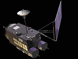
The Japanese telecommunications satellite JCSAT-11 was rolled out over the weekend to launch pad No.200 at the Baikonur cosmodrome. Liftoff of the Proton-M launch vehicle with a Briz-M upper stage is scheduled for 6:43 p.m. EDT tonight.
Built by Lockheed Martin, JCSAT-11 is a hybrid satellite, equipped with Ku-band high-power transponders and C-band medium-power transponders. For the time being, JCSAT-11 will be reserved entirely in orbit as a back up satellite for other JCSAT satellites as part of JSAT’s efforts to build a seamless global network.
ILS is lifting the bird. They’ve set up a launch blog, though the most recent post is a few days old:
Bright and early Friday morning (well, not that bright, as the sun was just rising), the entire launch vehicle was rolled out to the Breeze M fueling station, where its propellants (fuel and oxidizer) were loaded into the upper stage over a two-day span. These operations are entirely in the hands of our partners at Krunichev and the Russian Space Forces, so our team had a little bit of time to catch up on administrative tasks. In the meantime, the Russian state commission arrived on the second day of fueling and gave the go-ahead for the integrated launch vehicle to roll to the pad with the JCSAT-11 satellite.
During these two fueling days, our team had a chance to sneak in a quick tour of the launch pad, which was used for the Russian N-2 Moon Booster and Energia boosters in years past. These were truly massive rockets, with a lift capability of over 100 metric tons (220,000 pounds) to Low Earth Orbit! The sheer scale of the pad was equally large and impressive.
On a related note, JSAT is helping the Widely Integrated Distributed Environment (WIDE) Project, which is seeking to produce the next generation of communications and broadcasting based on the IPv4 and IPv6 multicast technology. WIDE recently announced an IPTV partnership with the Open Student Television Network (OSTN), which we recently blogged about here.
As always, we’ll update you on the launch in the comments below.


 The
The