Archive for the ‘Observation’ Category

GeoEye Awarded Airport Mapping Project

Thursday, June 22nd, 2006

There’s little doubt that satellite technology has transformed aviation. From the widespread use of GPS technology to the in-flight weather updates provided to pilots through services like XM Satellite Weather, satellite-delivered content and information has greatly increased the situational awareness of pilots and, in turn, made aviation safer.

Yet any gadget is only as useful as the underlying information, which is why the National Geospatial-Intelligence Agency (NGA) Stereo Airfield Collection program has awarded Dulles-based GeoEye a $3.7 million contract to image 365 airfields and produce Airport Mapping Databases (AMDB) over a 12-month period:

GeoEye is now the world’s largest developer of airport geospatial information support, terrain and obstacle databases with several hundred airfields mapped to date. Matt O’Connell, GeoEye’s president and chief executive officer said, "We are a leader in providing airport geospatial solutions to key customers like the NGA and the USAF at the best price and with the best performance in the industry."

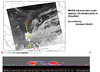
An Airport Mapping Database is a geospatial database that contains significant features of an airport such as runways, taxiways, buildings, obstacles and terrain surrounding an airfield. This information supports the safe movement of aircraft and helicopters on runways and taxiways. These products can also be used to support training, mission or contingency planning and visual simulations for ordinary operations or crisis situations. GeoEye is uniquely positioned to fulfill this contract for North American and international airfields by virtue of its IKONOS satellite’s ability to generate a three-dimensional image from stereo data collected during a single orbital pass. The result is a three-dimensional map-accurate image of an airport that can be quickly and cost effectively acquired.


Taepodong Tease

Tuesday, June 20th, 2006

While the U.S. is in the midst of a major naval exercise in the Pacific, near Guam, North Korea has reportedly fueled up a Taepodong missile and is ready to light the fuse.

Among the three U.S. aircraft carrier groups, 30 warships, 280 aircraft and 22,000 soldiers taking part in the naval exercises is the USS John McCain. The exercises, "Valiant Shield 2006," marks the first time a Chinese delegation is observing.

Now is not the best time to test an ICBM over the Pacific. You know Japan is not happy about it and has made it known. They’re still upset about the 1998 missile test.

As reported by the AP:

This is an Orbview-3 satellite image provided by GeoEye showing the Taepodong missile launch complex in North Korea, called Musudan-ri, in May 2006. North Korea referred to its missile program Monday, June 19, 2006 in its official media for the first time since it apparently began preparations for a test launch, as a U.S. official confirmed the North has completed fueling a missile that is poised to fire.


KazSat-1 Satellite Launched

Tuesday, June 20th, 2006

Kazakhstan launched its first communications satellite on 18 June

KazSat-1 Launch

2006 from the Baikonur Cosmodrome. The launch was personally seen by Kazakh president Nursultan Nazarbayev, who invited 18 leaders from media and communications in Russian and Kazakhstan.

The satellite’s advantages will provide for greater communications autonomy and security for the vast Kazakh steppes and new industrial development in the entire region.

The Great Kazoo

Contrary to some rumors among the space cadets, they did not adopt Kazoo from The Flintstones as their mascot.


Staring into the Sun

Thursday, June 15th, 2006

You’ve heard it since high school. Staring into the sun is bad for your eye. Fortunately, you now have a satellite to do it for you, and even take pictures. I happened across this MetaFilter thread about the TRACE, the Transitional Region and Coronal Explorer, and discovered a treasure trove of photographs shot by the satellite. Kinda like this one.

Solar Flair

TRACEBuilt and launched in April of 1998, on a mission to enable scientists to "study the connections between fine-scale magnetic fields and the associated plasma structures on the Sun in a quantitative way by observing the photosphere" (whatever that means) the satellite isn’t exactly new. But it took its millionth picture of the sun back in October of 1999. So it’s a great source of photographs that make great wallpaper for your desktop your IM profile, as well as movies that just make interesting viewing.

Cisco Getting Into Satcom

Monday, June 12th, 2006

Israel’s Globes Online reports Gilat’s SkyEdge technology, having met Cisco’s development criteria, will be incorporated into enterprise routers, helping customers with voice, video, data and wireless communications transmission over high speed satellite networks.

Gilat CEO and president Amiram Levinberg said, “Teaming with Cisco in developing and marketing interoperable networking solutions truly differentiates Gilat in the VSAT market and shows our commitment to provide our customers with an edge beyond the latest technology, via its cooperation with market leaders. We believe Cisco’s interest to add satellite communication capability into its enterprise routers is good news for the satellite industry in general as it expands the addressable market for satellite communication technology and services.”

Gilat’s U.S. subsidiary Spacenet is selling Cisco-compatible network modules today. Glad to see their technology is getting traction in the U.S.

I like their fruity video.

Above the Clouds

Monday, June 12th, 2006

More pictures from space. This time it’s NASA using satellites to look inside storm clouds, in order to predict how much water they hold and how much might fall.

CloudSat

The first images from a $217 million satellite project to measure the moisture content of clouds provided breathtaking views of storms on Earth, scientists said.

“For the first time we’re seeing inside the clouds,” said Graeme Stephens, a Colorado State University atmospheric sciences professor and the principal investigator for the CloudSat project. “We can see tropical storms 15 kilometers deep organized on scales of thousands of kilometers across.”

CloudSat, a formation of five satellites launched April 28, was developed by CSU researchers in conjunction with other agencies to determine the moisture content of clouds, in the hope of developing long-term precipitation models.

“We want to know how much water is in the sky so we can see how much water falls,” Stephens said.

The spacecraft are 438 miles above the Earth.

NASA, of course, has the latest photos.

Satellite Broadband Activity

Sunday, June 11th, 2006

NRTC Welcomes New WildBlue Providers HERNDON, Va.

HERNDON, Va., June 9 /PRNewswire/ — Today, WildBlue Communications, Inc. announced agreements with satellite television providers DIRECTV, Inc. and EchoStar Communications Corporation (DISH Network) to distribute WildBlue satellite Internet access.

The National Rural Telecommunications Cooperative (NRTC) welcomes the efforts of these national providers to bring broadband Internet access to rural America.

"Beginning in 2002, NRTC and our members invested in WildBlue because we knew it would be a great service and would meet a critical need," said Bob Phillips, NRTC’s president and CEO, and member of the WildBlue Board of Directors. "NRTC members proved the benefit of the WildBlue business during its first year of operations. It is gratifying to see companies like EchoStar and DIRECTV recognize the value of such a great and needed product."

During much of the first year of WildBlue service availability, NRTC- member electric and telephone rural utilities have been the primary distributors of WildBlue satellite Internet service, bringing access to news, information and entertainment that was previously unavailable to many rural residents, and serve nearly 40,000 of the 60,000 current WildBlue subscribers.

"While WildBlue continues to expand our wholesale distribution network, we recognize the current and long term value of the NRTC membership in our distribution efforts," said Dave Leonard, WildBlue’s CEO. "NRTC has and will continue to play a vital role in the delivery of satellite broadband to rural America. WildBlue remains committed to the success of the NRTC member distribution effort."

"Our members are pioneers who have historically recognized the importance of bringing much-needed telecommunications solutions to rural America," continued Phillips. "They see a need and fill it early. Our members were instrumental in launching and distributing DIRECTV satellite television service, and for the last year they have filled an equally important role as the primary distributors of WildBlue. NRTC members are known and trusted service providers in their communities and will continue to fill this valued role by providing their core utility services as well as important diversified services such as WildBlue."

About NRTC

NRTC leads and supports more than 1,300 member organizations by delivering telecommunications solutions to strengthen member business, promote economic development, and improve the quality of life in rural America. The rural utilities that make up NRTC offer services to more than 30 million rural households in the United States. For more information, visit http://www.nrtc.coop.
National Rural Telecommunications Cooperative

Web site: http://www.nrtc.coop/

Sirius to Add Fourth, Geostationary Satellite

Friday, June 9th, 2006

Is Sirius looking to expand its product offerings? That’s the question that lingers between the lines in yesterday’s news reports that Sirius has agreed to a $260 million contract with Space Systems/Loral to launch a fourth satellite:

 Loral Space & Communications Ltd.’s (LORL) Space Systems/Loral unit, which built Sirius’s three existing in-orbit satellites and a fourth back-up satellite in storage, is constructing the new satellite – the FM-5. It is slated for completion in the fourth quarter of 2008. Once completed, the satellite will be launched on a Proton rocket under an existing contract with International Launch Service.

Sirius said the new satellite will help enhance overall coverage, particularly for stationary applications at home or in the office. Unlike the company’s current satellites, which travel in a figure-eight pattern above and below the equator that is known as an "elliptical geosynchronous orbit," the FM-5 will stay in a fixed position above the earth – a "geostationary orbit." Sirius said having a satellite in the different orbit will complement existing coverage. Rival XM Satellite Radio Inc. (XMSR) has all of its satellites in geostationary orbits.

With this new satellite, Sirius and XM will have the same number of satellites. XM is currently building a fourth satellite that is expected to launch in the second half of the year. It also has a spare under construction that is scheduled to be completed by the end of 2007.

A good explanation of how Sirius’ current satellite system works can be found here. Bell Labs did some work for Sirius (see here), and the question on analysts’ minds is whether the new geosynchronous satellite signals (no pun intended) an intention by Sirius to move into the market of providing video as well as radio to cars and buses. 

Time will tell. 


Scientists Sky-High Over First CloudSat Images

Thursday, June 8th, 2006

Last month we wrote about the launch of the CloudSat and Calipso satellites. Now reports are coming back that the first images from Cloudsat are giving scientists a completely new view of the clouds:


"We’re seeing the atmosphere as we’ve never seen it before," says Deborah Vane, CloudSat deputy principal investigator at NASA’s Jet Propulsion Laboratory in Pasadena, California, US. "We’re no longer looking at clouds like images on a flat piece of paper, but instead we’re peering into the clouds and seeing their layered complexity…."

CloudSat’s Cloud Profiling Radar, the first millimetre-wavelength radar, underwent tests in late May and was formally activated on 2 June.

"All major cloud system types were observed, and the radar demonstrated its ability to penetrate through almost all but the heaviest rainfall," says Graeme Stephens, CloudSat principal investigator and atmospheric scientist at Colorado State University, US.

The first image is a cross-section of a warm storm front above the Norwegian Sea taken on 20 May. In the image, red represents highly reflective particles such as raindrops, ice crystals or snowflakes. Blue represents thinner cirrus clouds.

The radar also provided a look at a night snow storm near Antarctica. The long winter nights make traditional remote sensing difficult in the polar regions and CloudSat is the first satellite able to detect snowfall from space.

A third image shows tall thunderstorm clouds over east Africa.

The results are still preliminary, but the mission team aims to release validated science data within nine months.

CloudSat is part of the A-Train, a constellation of five satellites that fly right behind one another, measuring the same swath of Earth.

The picture above is "CloudSat’s first image, of a warm front storm over the Norwegian Sea, was obtained on May 20, 2006. In this horizontal cross-section of clouds, warm air is seen rising over colder air as the satellite travels from right to left. The red colors are indicative of highly reflective particles such as water droplets (or rain) or larger ice crystals (or snow), while the blue indicates thinner clouds (such as cirrus). The flat green/blue lines across the bottom represent the ground signal. The vertical scale on the CloudSat Cloud Profiling Radar image is approximately 30 kilometers (19 miles). The blue line below the Cloud Profiling Radar image indicates that the data were taken over water."

For more information on Cloudsat, visit the NASA CloudSat website.

Jason-2 in Space

Tuesday, June 6th, 2006

It has nothing to do with Wes Craven and is not nearly as scary as it sounds: new details have been released about the Jason-2 (Joint Altimetry Satellite Oceanography Network) satellite set to be launched from Vandenberg AFB in October 2008. In a demonstration of international cooperation in global warming research, the Japan Aerospace Exploration Agency is working with the French company CNES on the project:

The science objectives of Jason-2/OSTM are to extend the time series of ocean surface topography measurements to: a) obtain a continuous record of observations (with the previous missions), b) to determine the variability of ocean circulation at decadal time scales from combined data record with T/P and Jason, c) improve the measure of the time-averaged ocean circulation, d) improve the measure of global sea-level change, and e) improve open ocean tide models.

The mission objectives call for the provision of the same measurement accuracy of Jason (3.3 cm) with a goal of achieving 2.5 cm, and to maintain the stability of the global mean sea level measurement with a drift less than 1 mm/year over the life of the mission. The overall goal is to better understand the forces behind global changes of climate and to predict seasonal anomalies in weather patterns; this is vital to understand the physics of the ocean.

Jason-2 is scheduled to join Jason-1 in the same orbit with a 10 day repeat observation cycle. Both satellites will pass within minutes of each other over the same ocean surface, thus enabling verification and cross-calibration of the collected data. Together, they will provide a vital contribution to the expanding network of global ocean observations and their application in meteorology, operational oceanography and climate monitoring.