Archive for 2006

U.S. National Space Policy

Wednesday, October 18th, 2006

"Consistent with this policy, the United States will: preserve its rights, capabilities, and freedom of action in space; dissuade or deter others from either impeding those rights or developing capabilities intended to do so; take those actions necessary to protect its space capabilities; respond to interference; and deny, if necessary, adversaries the use of space capabilities hostile to U.S. national interests."

Click here to read the unclassified version.

Interesting: a comparison to Clinton’s policy of 1996.

X-Prize Cup Tournament This Friday & Saturday in New Mexico

Wednesday, October 18th, 2006

For readers that haven’t established weekend plans just yet, you might want to consider a quick jaunt out to La Cruces, NM where the Wirefly X-Prize Cup will be taking place this coming Friday and Saturday (Oct. 20 & 21).

The main event of the weekend will, of course, be the $2.5 million in Prize competitions that will being going on throughout the exposition.

The Northrop Grumman Lunar Lander and Vertical Lander Challenge will probably be on of the most watched events, but the Spaceward Foundation‘s Space Elevator Challenge may be among its most technically interesting. In the Space Elevator Games, teams will be competing for two, separate $200,000 prizes, one for who builds the best climber (a machine capable of traveling up and down a tether ribbon, with powering being beamed to a transmitter on the device) and the team that builds the strongest tether (first competing against other teams and then by proving that its tether is 50% stronger than the off-the-shelf variety.

While we’ve written about the space elevator competition in the past, Really Rocket Science readers will also have a leg-up on other attendees in terms of other events going on at the space exposition. Also taking place during the fair will be the unveiling of the Rocket Racing League’s X-Racer (written about at RRS here) and meet and greet with the world’s first space tourist, Anousheh Ansari (written about on RRS just a few weeks ago).

Stay tuned to Really Rocket Science for all the information coming out of New Mexico in the next few days. While we won’t be there, we’re going to stick to this story in the days ahead.

MetOp Launches Today at 2:28 pm EDT

Tuesday, October 17th, 2006


The BBC reports on Europe’s first polar-orbit satellite:

Europe is set to launch its most sophisticated weather and climate satellite to date.

The MetOp spacecraft will be lofted into its 850km-high polar orbit by a Soyuz-Fregat vehicle from Kazakhstan.

The platform should improve forecasting globally, and give scientists detailed data they can use to refine models describing how Earth’s systems work.

Metop has eight instruments to gather a range of data about the planet’s atmospheric and surface conditions….

Metop is a joint project of the European Space Agency (Esa) and Eumetsat, the intergovernmental organisation charged by European member states with operating a series of orbiting weather observatories….

The new platform weighs more than four tonnes and measures almost 18m (60ft) with its solar wing unfurled.

The Eumetsat website will feature a stream broadcasting the launch live. For more information on the satellite, visit the ESA Portal, or click here for a cool animated video explaining the satellite and its mission.

Set Your Watches: New Break Through in Atomic Clocks

Monday, October 16th, 2006

"Most technical systems that employ satellites, including GPS technology, make use of atomic clocks; these technologies can now operate much more accurately," thanks to a recent breakthrough in understanding errors in atomic clock technology, ScienceDaily reports:

Andrei Derevianko, Kyle Beloy, and Ulyana Safronova [of the University of Nevada, Reno] sat down six months ago and began work on a calculation that will help the world keep better time….

Associate physics professor Andrei Derevianko and his team isolated and explained a significant portion of the error in atomic clock output….

In its research, the University team was able to isolate and explain a significant portion of the error in atomic clock output. The portion of error that the team studied has now been cut to one-fiftieth of its original size. The team’s research was based solely on calculations, many of which were conducted on high performance computers…

In 2004, an Italian research team found some convincing evidence that suggested that atomic clocks were less accurate then previously thought. This evidence concerned the scientific community and gave the theory behind atomic clocks renewed international attention….

Atomic clock technology is based on the fact that atoms emit a fixed frequency. Lasers, which also have operating frequencies, can be calibrated so that their frequencies match that of a given atom. Since atomic frequencies are constant, syncing a laser with an atom and counting the laser’s oscillations will always provide a steady measurement of time….

The new findings are also paving the way for all kinds of new scientific experimentation. Extremely accurate measurements are required to make estimations about the behaviors of the universe. The extra time-keeping precision will allow scientists to explore hypotheses about the big-bang theory. The improved technology might even be accurate enough to provide evidence related to the controversial theory that universal constants, as in the amount of charge in an electron, are changing.

So how does one tune in to the more accurate atomic clock? Why, with an atomic clock receiver, of course:

A radio system is available in North America set up and operated by NIST – the National Institute of Standards and Technology, located in Fort Collins, Colorado. NIST operates radio station WWVB, which is the station that transmits the time codes. WWVB has high transmitter power (50,000 watts), a very efficient antenna and an extremely low frequency (60,000 Hz). For comparison, a typical AM radio station broadcasts at a frequency of 1,000,000 Hz. The combination of high power and low frequency gives the radio waves from WWVB a lot of bounce, and this single station can therefore cover the entire continental United States plus much of Canada and Central America. The time codes are sent from WWVB using one of the simplest systems possible, and at a very low data rate of one bit per second. The 60,000 Hz signal is always transmitted, but every second it is significantly reduced in power for a period of 0.2, 0.5 or 0.8 seconds: • 0.2 seconds of reduced power means a binary zero • 0.5 seconds of reduced power is a binary one. • 0.8 seconds of reduced power is a separator. The time code is sent in BCD (Binary Coded Decimal) and indicates minutes, hours, day of the year and year, along with information about daylight savings time and leap years. The time is transmitted using 53 bits and 7 separators, and therefore takes 60 seconds to transmit. A clock or watch can contain an extremely small and relatively simple antenna and receiver to decode the information in the signal and set the clock’s time accurately. All that you have to do is set the time zone, and the atomic clock will display the correct time.


Nice Launch: Ariane 5 ECA

Monday, October 16th, 2006

Mission réussie pour Ariane 5 ECA

Dans la nuit du vendredi 13 au samedi 14 octobre 2006, Arianespace a mis en orbite de transfert géostationnaire le satellite DIRECTV 9S pour l’opérateur américain DIRECTV et le satellite OPTUS D1 pour l’opérateur australien OPTUS. Grâce au plateau ASAP 5, le lancement emportait également le réflecteur expérimental LDREX-2 pour l’agence spatiale japonaise JAXA.

Arianespace placed two satellites into geostationary transfer orbit: DIRECTV 9S for the U.S. operator DIRECTV Inc., and OPTUS D1 for the Australian operator OPTUS. The Ariane 5 ECA launcher was also fitted with the ASAP 5 platform, allowing it to deploy the LDREX-2 experimental reflector for the Japanese space agency JAXA.

Provisional parameters at injection of the cryogenic upper stage (ESC-A) were:
Perigee: 249.4 km for a target of 249.5 km (±3)
Apogee: 35,940 km for a target of 35,946 km (±160)
Inclination: 6.98 º for a target of 7.0 degrees (±0.06º)

DIRECTV 9S was built by Space Systems/Loral in Palo Alto, California, and will be positioned at 101 degrees West. Weighing approximately 5,530 kg at liftoff, DIRECTV 9S is fitted with 52 high-power Ku-band transponders and 2 Ka-band transponders. It will provide direct TV broadcasts using digital compression technology. DIRECTV 9S will give American TV viewers a greater choice of broadcast services, while prefiguring tomorrow’s multibeam satellites for multimedia applications. Design life is about 15 years.

OPTUS D1 was integrated by American manufacturer Orbital Sciences Corporation in Dulles, Virginia, based on a Star-2 platform. OPTUS D1 will weigh about 2,300 kg at launch. Positioned at 160 degrees East, it will provide direct TV broadcasts, Internet links, voice and data services for Australia and New Zealand. Its design life is 15 years.

LDREX-2 (Large-scale Deployable Reflector Experiment 2), launched on behalf of the Japan Aerospace Exploration Agency (JAXA), is a small-sized partial model representing the large deployable antenna to be used on the ETS-8 technology satellite, which will be launched in December 2006.

DIY Friday: Installing C-Band at Home

Friday, October 13th, 2006

So you’ve made the decision to get a C-Band receiver at home, so you can watch (what else?) NASA TV and other free to air channels from around the globe.

Now, you think, it’s DIY Firday — and how the heck do you hook the thing up to your dish?

HomeCable.com offers a set of standard instructions and diagrams to help you get started. 


There are several places online where you can get C-band receivers and antennas. Sadoun Satellite sales offers the Fortec Star FC6D. Mechtech and RPS Satellite offer several models, as does Global Communications.

What other sources do readers turn to for their antenna and receiver needs? Let us know in the comment threads — or if there are other DIY Friday topics you’d like to see us cover. 

Arianespace to Launch DirecTV Satellite Tomorrow

Thursday, October 12th, 2006

Among those who aren’t suspicious of undertaking major endeavors on Friday the 13th, you can include both Arianespace and DirecTV.

The Ariane 5ECA rocket is scheduled to launch tomorrow afternoon between 4:56 and 5:56 pm, U.S. Eastern time. The launch will take place from the ESA spaceport in Kourou, French Guiana.

The launch will service three customers and deploy three satellites: DirecTV’s 9S, Optus’ Optus D1, and JAXA’s LDREX-2.  

The 9S satellite "will be capable of providing up to 54 transponders for high-quality local and national digital video service broadcast into 27 beams. In an alternate configuration, the satellite will be capable of providing up to 44 transponders broadcast into 30 beams."

Want to know what to expect from the launch, second by second? Check out Spaceflight Now’s cool launch cue card

Dust Devils on Mars

Wednesday, October 11th, 2006

This morning we stumbled across this article in the Columbus Dispatch (written under contract by NASA), and we were reminded again of one of the cooler images to come from our solar system in the last few years.

The image is of a dust devil moving across a Martian plain on a hot spring afternoon a year ago:


The image was caught by NASA’s ‘Spirit’ Mars Rover in April, 2005. 

Both rovers (Spirit and Opportunity) have recently been upgraded with new software that enables them to better understand when a dust devil is moving across the martian surface, and to begin snapping pictures when they sense that movement:

NASA’s Space Technology 6 mission, or ST6, had already proven this "artificial intelligence" software in space. ST6 used it to help an Earth-orbiting satellite take pictures of erupting volcanoes on Earth. So NASA knew the software would help Spirit and Opportunity capture images of dust devils.

ST6 is part of NASA’s New Millennium Program, whose job is to test new technologies in space before putting them on NASA missions of discovery.

Other images and video from Mars can be found on NASA’s Mars Exploration Program website. 

Labrador Internet Connections At Risk

Tuesday, October 10th, 2006

Sailing from England with one vessel, the Matthew, on 20 May 1497, John Cabot (Giovanni Caboto) and a crew of 18 reached what some historians now believe was Labrador on 24 June 1497. He went ashore to take possession of the land, exploring the coast for some time and departing on or about the 20th of July.

Upon his return to England, Cabot was well rewarded (a pension of 20 pounds a year), and a patent was written for a new voyage. In 1498, he sailed for America with 5 ships. One of the ships became distressed and diverted to an Irish port. Nothing was ever heard of the other — or John Cabot — ever since.

Will the same happen to Internet connections in Labrador today? The CBC reports that’s what might happen if Industry Canada’s Community Access Program (CAP) cuts funding. In a town like Black Tickle, where dial-up service became available only recently, people see the need:

The cut may mean the closure of 21 internet sites in Labrador. In many coastal communities, the only efficient way to connect to the internet is via satellite.

Brenda Roberts, principal of St. Peter’s school in the southern Labrador community of Black Tickle, said CAP sites are used broadly. Students use the connection for research, and the school’s administration depends on it.

"Our fee for this internet connection to [the] satellite system is around $220 a month, so basically, if you compare it to a human body, well, we’re going to die of heart failure in January," Roberts said.

Residents in the community rely on satellite-based CAP sites for everyday things, including commerce and filling out government forms.

"We’ve got no bank here now and it’s easier to get a piece of gold nugget here than cash, so being able to bank online is all right," she said.

Who will step in to help? Will it be Canada’s dominant satellite operator, Telesat? Perhaps this is the type of situation where Telesat’s new competitor, Ciel Satellite, saves the day? There are other options, of course: resellers such as Barrett Xplore, who use satellites operated by Intelsat.

Korean Ping-Pong

Tuesday, October 10th, 2006

As the debate rages in the press as to whether Pyongyang’s 60-year obsession came to fruition on Sunday — or, if, as Drudge is reporting, the North Korean blast was a  "dud" — it’s worth taking a moment to ask: how do we come to conclusions about what really happened?

To do so, it’s worth recounting how the United States learned about the blast.  

Our initial warning that the nuclear test was about to take place came not from a high-tech gizmo, but in a phone call from the Chinese:

The White House said Monday the United States received word from China of North Korea’s intent to conduct a nuclear test minutes ahead of the reported event.

According to spokesman Tony Snow, North Korea had called its ally China to advise them on the imminent explosion at about 9 p.m. EST Sunday. China in turn notified the U.S. Embassy in Beijing, which relayed the message to Washington.

Secretary of State Condoleeza Rice received notification about 9:45 p.m. and notified national security adviser Stephen Hadley. Hadley called President George W. Bush at about 9:52 p.m.

South Korean authorities said they felt the seismic tremor from an apparent explosion in North Korea in about the same time frame of Hadley and Bush being notified.

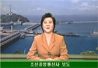
 In addition to indications on the ground in South Korea, there was the on-the-air announcement in North Korea:


Soon thereafter, the USGS and other agencies began to analyze the seismic data to locate the epicenter and identify the magnitude of the tremors that were registered on seismic monitors. In this case, the magnitude was 4.2, and the location was pinned down (though not literally, of course) on the map.

NOAA’s NESDIS satellite likely played a key role in communicating the scientific (non-intelligence) data, and satellite telemetry helped pinpoint the location of the tremor. 

The result? So far, a good deal of doubt on behalf of the West in regards to North Korea’s claims of success:

U.S. officials, speaking on the condition of anonymity, said that seismic readings show that the conventional high explosives used to create a chain reaction in a plutonium-based device went off, but that the blast’s readings were shy of a typical nuclear detonation.
   
"We’re still evaluating the data, and as more data comes in, we hope to develop a clearer picture," said one official familiar with intelligence reports.
   
"There was a seismic event that registered about 4 on the Richter scale, but it still isn’t clear if it was a nuclear test. You can get that kind of seismic reading from high explosives."
   
The underground explosion, which Pyongyang dubbed a historic nuclear test, is thought to have been the equivalent of several hundred tons of TNT, far short of the several thousand tons of TNT, or kilotons, that are signs of a nuclear blast, the official said.

The official said that so far, "it appears there was more fizz than pop."

Without satellites and seismic monitors, however, it would be impossible to say whether it was fizz, pop, or outright propaganda on the part of North Korea.