Looks Like Kutztown
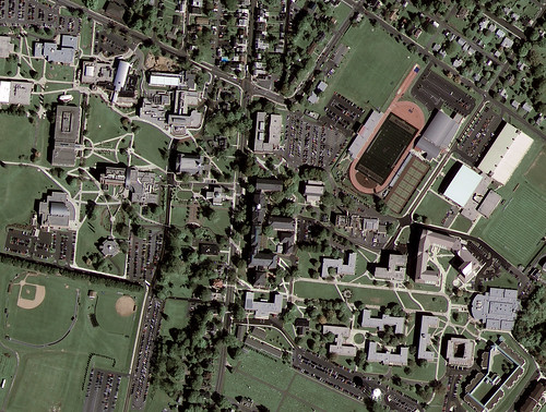
GeoEye-1’s first image released of Kutztown University in Pennsylvania:
GeoEye, Inc. (NASDAQ: GEOY), a premier provider of satellite, aerial and geospatial information, released today the first, color half-meter ground resolution image taken from its GeoEye-1 satellite. The satellite has been undergoing calibration and check-out since it was launched on Sept. 6 from Vandenberg Air Force Base in Calif. The Company will begin selling GeoEye-1 imagery products later this fall.
The Kutztown University image shows the campus, which includes academic buildings, parking lots, roads, athletic fields and the track-and-field facility. The image was collected at 12:00 p.m. EDT on Oct. 7, 2008 while GeoEye-1 was moving north to south in a 423-mile-high (681 km) orbit over the eastern seaboard of the U.S. at a speed of four-and-one-half miles per second. GeoEye-1 was built by General Dynamics Advanced Information Systems in Gilbert, Ariz. The imaging system was built by ITT in Rochester, NY.