Brazilian Observation Satellite Launched by Chinese

There are a lot of happy rocket scientists in Brazil today:
CBERS-2B é lançado com sucesso da base chinesa de Taiyuan
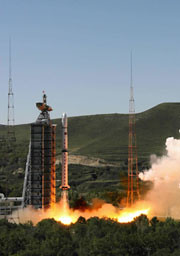
Exatamente às 00h26min desta quarta-feira (19) foi lançado com sucesso o CBERS-2B, terceiro satélite da parceria entre Brasil e China. O evento foi comemorado tanto no Centro de Controle de Satélites do INPE, em São José dos Campos (SP), como no Centro de Lançamento de Satélites de Taiyuan. O diretor do INPE, Gilberto Câmara, assistiu ao lançamento na base chinesa e, junto com os engenheiros Ricardo Cartaxo e Jânio Kono, respectivamente coordenador geral e coordenador do Segmento Espacial do Programa CBERS, transmitiu todas as informações aos técnicos e convidados que acompanharam da sede do Instituto.
“É uma emoção muito grande. É o resultado de um grande trabalho feito por brasileiros e chineses. Estamos todos muito orgulhosos”, disse o diretor Gilberto Câmara.
Chefe do Centro de Controle de Satélites do INPE, Pawel Rosenfeld manteve contato constante com Jânio Kono, coordenador do Segmento Espacial do Programa CBERS, que da base comandou as operações junto com os técnicos chineses.
O foguete Longa Marcha 4B cumpriu perfeitamente todas as etapas previstas para colocação do satélite em órbita. O tempo total de vôo até a injeção do CBERS em órbita foi de 12,5 minutos. O CBERS-2B é lançado com seus transmissores ligados permitindo assim que a estação de rastreio de Nanning, na China, mantenha contato com o satélite desde antes de sua separação do último estágio do veículo lançador, até aproximadamente um minuto e meio após a abertura dos painéis solares, que aconteceu cerca de 14 minutos após o lançamento.
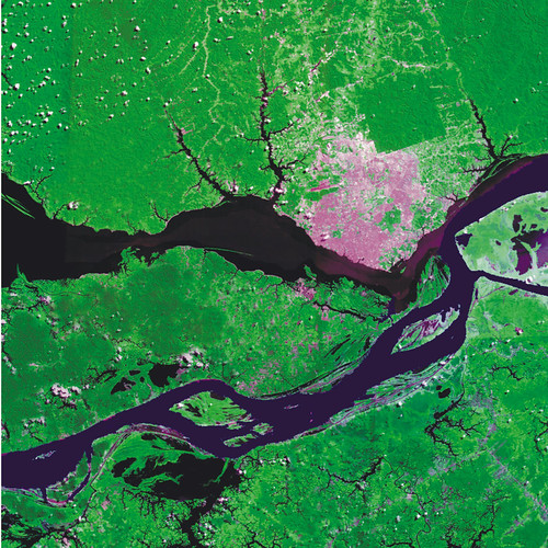
The spacecraft is capable of producing images such as this beauty of Manaus:
Here’s the explanation, in English, via SpaceFlightNow.com:
A joint mission developed by China and Brazil was shot into an orbit circling Earth’s poles to snap detailed images of the globe during an early Wednesday launch from China’s northeastern space base.
A Long March 4B rocket launched with the international satellite at 0326 GMT Wednesday (11:26 p.m. EDT Tuesday) from the Taiyuan space center in China’s Shanxi province, according to the state-run Xinhua news agency.
The booster’s three liquid-fueled stages accurately deposited the third China-Brazil Earth Resources Satellite into a Sun-synchronous orbit about 12 minutes after liftoff.
CBERS 2B was left in a nearly circular orbit with an average altitude of approximately 462 miles, Xinhua reported. The Long March 4B was shooting for an orbital inclination of 98.5 degrees.
Wednesday’s launch marked the 60th consecutive success for China’s Long March rocket fleet. It was also the 8th space launch for China so far this year.
CBERS 2B will spend the next few weeks undergoing systems tests and preparations for an operational mission expected to last at least two years.
The 3,200-pound satellite was ordered by Chinese and Brazilian officials in 2004 to bridge the gap between older spacecraft and next-generation satellites, which should begin launching in 2009.
The craft’s predecessors, CBERS 1 and CBERS 2, were launched by Chinese rockets in 1999 and 2003, respectively. Both outlived their baselined two-year missions, according to Brazil’s National Institute for Space Research, a co-sponsor of the program.
The China Academy of Space Technology was in charge of the Chinese contribution to the mission, Xinhua reported.
CBERS 2B carries three primary imaging cameras to take a wide range of pictures of locations scattered throughout the world.
A low-resolution camera with a 60-degree field of view will specialize in capturing images of large swaths of the planet. Another camera will be capable of taking pictures with a resolution of about 65 feet.
Unlike its forerunners, CBERS 2B includes a high-resolution black-and-white camera able to produce images showing objects as small as 2.5 meters, or about eight feet. CBERS 1 and CBERS 2 each carried an infrared scanning instrument instead.
Scientists expect to use data from the project in environmental monitoring, crop planning and managing water resources. Images can also be used to identify types of vegetation and in soil surveys. Pictures could also end up in geography textbooks, according to Brazilian space officials.
Images from the new high-resolution camera will also be useful in urban planning and military intelligence applications for China and Brazil.
China has a 70 percent stake in the 19-year-old program, while Brazil controls about 30 percent of the project. Users in both nations have access to the satellite imagery.
Pictures from the spacecraft have been distributed online since 2004, and more than 15,000 users have downloaded about 320,000 images since the Internet campaign began, according to Brazilian officials.
Two more satellites with four cameras each will be launched in 2009 and 2011. The program extension was approved in 2002, and China and Brazil will equally split responsibility for the new project.
Here’s a video about the Brazilian Space Agency:
And here’s a little Brazilian space center tribute video set to Brazilian metal (mind the volume):