Ready, Aim
We’ve been following this story for a few weeks now, and it is astounding how much attention has been paid to it. A top-secret U.S. observation satellite that’s out of control is set to be shot out of the sky precisely so it brings no harm to the public. Over the Pacific Ocean, for example, would be a good location. Now the U.S. Navy has issued a "notice to airmen," signaling just that:
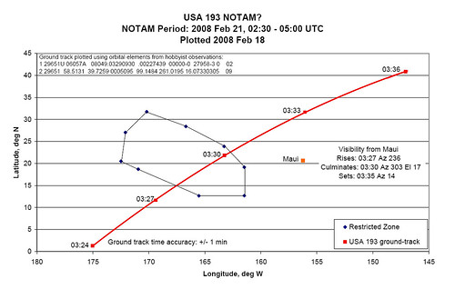
02/062 (A0038/08) – AIRSPACE CARF NR. 90 ON EVELYN STATIONARY RESERVATION WITHIN AN AREA BNDD BY 3145N 17012W 2824N 16642W 2352N 16317W 1909N 16129W 1241N 16129W 1239N 16532W 1842N 17057W 2031N 17230W 2703N 17206W SFC-UNL. 21 FEB 02:30 2008 UNTIL 21 FEB 05:00 2008. CREATED: 18 FEB 12:51 2008
The Register explains what this means:
A "CARF" (Central Altitude Reservation Function) designation indicates a NOTAM intended to keep commercial and private flights clear of military operations, and SFC-UNL means the height band of this warning zone reaches from the surface to "unlimited" altitude – in other words all the way into space. The UTC time referred to is the same as UK time, so the zone exists from 0230 to 0500 on Thursday morning for British readers.
As will be evident, the barred area is a cool 1,400 miles long and nearly 700 miles wide at the surface, giving the US Navy plenty of elbow room to fire their interceptor missiles up into the descending spacecraft’s path.
Reports have it that three US Aegis air-defence warships, the cruiser Lake Erie and the destroyers Decatur and Russell, will be waiting for the satellite west of Hawaii. Each ship carries a specially modified Standard SM-3 interceptor, originally intended for defence against lower-flying ballistic missile warheads. The three interceptors are on separate ships in case of a technical issue with the Aegis radar and fire-control system.
As it passes over the firing area, the satellite will be approximately 3,000 miles and ten minutes out from the western coast of Canada, the next land it will pass over. The satellite has much more mass than the soaring "exo-atmospheric kill vehicle" it will smack into, so this gives some idea of the onward track the wreckage might follow in the event of a hit.
Google Earth kmz file by Alan Clegg is worth a look.
What can we expect on Thursday? Take a look at this Japanese test from last December: