Archive for the ‘Satellites’ Category

SOCOM: Moving With Satcom

Thursday, July 17th, 2008


Carl von Clausewitz once famously observed that war is the extension of politics by other means.

So it seems fitting, at least in the sense that truisms are true, that the satcom-on-the-go platform that has been bringing the American people live coverage of the presidential election (which we blogged about here) is now being used by U.S. Special Forces in the Middle East.

We’re speaking, of course, of the ArcLight Mobile Satellite Communication System by ViaSat. We’ve written before about how the broadcast networks use the system in moving vehicles, and how the same platform is being used by AMERICOM and KVH for maritime mobile broadband

Now comes a press release announcing that ViaSat Airborne Broadband Ku-band satcom is being deployed by U.S. Special Forces for real time data and video communications: 

The system is already in use in the Middle East and coverage areas will expand as more terminals and hubs are delivered. This new operational capability, an extension of the ArcLight® mobile broadband system, is installed on C-130 aircraft, primarily for sending high resolution video back to higher command authorities for further analysis and identification.

Here’s a video of the type of real-world situations that the ArcLight system can help commanders in-field and at the United States Special Operations Command address. It’s taken from an AC-130 Gunship observing insurgents in Iraq. (Warning: Video contains violence and may not be suitable for all viewers.)


 The C-130 satcom system is built around the advanced ArcLight modem and networking technology using a spread spectrum waveform to enable the use of mobile satellite antennas as small as 29 centimeters in diameter. The antenna is enclosed in a radome attached to a redesigned emergency escape hatch. In a few minutes, operators can configure an aircraft for their specific mission without any permanent aircraft alterations, then quickly return the aircraft to its normal configuration when the mission is complete, while maintaining safety-of-flight integrity. The U.S. Air Force-certified hatch-mount terminal enables secure access to Department of Defense wide area networks at raw data rates up to 10 Mbps inbound and 512 kbps outbound while airborne.

EchoStar XI Launch Update

Tuesday, July 15th, 2008

Set for tonight at 10:21pm PST via Sea Launch:

Long Beach, Calif., July 14, 2008 – The Sea Launch team arrived at the launch site in the Equatorial Pacific over the weekend and initiated a 72-hour countdown, in preparation for the launch of the EchoStar XI satellite on Tuesday, July 15. Liftoff is planned at 10:21pm PDT, July 15 (5:21 GMT, July 16), at the opening of a two-hour launch window.

Upon arrival at the launch site, at 154 degrees West Longitude, the team ballasted the Odyssey Launch Platform to launch depth. A final series of tests on all systems is now underway. Prior to fueling operations, the platform will be evacuated, with all personnel safely positioned on the ship, about four miles from the platform. One hour after liftoff, a Zenit-3SL vehicle will insert the 5,511 kg (12,150 lb) EchoStar XI satellite into geosynchronous transfer orbit, on its way to a final orbital location of 110 degrees West Longitude.

Built by Space Systems/Loral (SS/L), the powerful 20-kW spacecraft, carries a Ku-band payload that will support DISH Network’s direct broadcast television service for its customers throughout the United States. This spacecraft is designed for a 15-year service life on orbit. This is the 3rd mission Sea Launch is executing for DISH Network and the 8th mission with a spacecraft built by SS/L.

Check out a live still webcam from the platform here and here. If you’re going to stay up late, you can watch live coverage of the launch here. And Sea Launch has extensive coverage of the mission and satellite here.

With DISH Network promising 130 HD channels by the end of 2008, this satellite launch is, like all of them, very important. And this launch couldn’t be mre timely, as DISH just surpassed 100 channels just a few days ago. And this means that DISH may have just surpassed DirecTV.

Canadian Innovation

Wednesday, July 9th, 2008

Some interesting news coming out of Canada recently, some of it satcom-related, and some not. Ciel Satellite received "approvals in principle" from Industry Canada to develop a half-dozen orbital locations over North America, right in the "sweet spot" for direct-broadcast satellite TV. Using the Ka-band for BSS spectrum (17/24 GHz) represents new capacity and will probably lead to more innovation. More HDTV channels? You better believe it.


We know RIM’s BlackBerry represents Canadian innovation at its finest, and the Canadarm contribution to the space program is well-known, but we couldn’t help but notice the news from Sky Hook International for a new transport system — using blimps:

A Calgary company will team up with aerospace giant Boeing to build a giant dirigible-like craft capable of lifting heavy loads for the oil and gas, mining and forestry sectors.

SkyHook International Inc. president Peter Jess said the companies plan to build two prototypes of the JHL-40 rotorcraft — a combination helicopter and blimp — before proceeding with a production run of 50 to 60 units.

According to company officials, there isn’t anything quite like it in existence and the prototypes will mark the commercial development of a whole new breed of aircraft.

"The list of customers waiting for SkyHook’s services is extensive and they enthusiastically support the development of the JHL-40."

The patented craft will be capable of hauling 40-tonne loads up to 320 kilometres in areas without basic infrastructure such as roads.

Jess said the first two initial craft would be deployed in the Arctic.

Formerly with Dome Petroleum, Jess said he came up with the idea decades ago while working in the Far North.

Boeing will build the prototypes at its manufacturing facility in Pennsylvania while SkyHook will own, maintain and operate the aircraft on a worldwide basis.

The JHL-40 has yet to be certified by aviation authorities in Canada or the United States and won’t come into service until 2012.

Innovation leads economic development in any business — especially satcom.


First Storm of the Season

Monday, July 7th, 2008


It’s officially hurricane season and Bertha is gearing up to be the year’s first storm.

Whether you might find yourself in the eye of the storm or you’re just intrigued by extreme weather, you’re sure to appreciate the fun tools that the National Weather Service puts out for the public. This one lets you track the storm’s movements. And this one shows wind speeds.

How do they get all the data for these cool images? Why satellites, of course. And the NOAA has a full arsenal. But how does all the information coming from those satellites turn into something we can understand, like this animation of the season’s first hurricane?

With Giovanni it’s simple. And no, that isn’t the name of an Italian tropical storm guru…

Giovanni is actually an acronym for the GES-DISC (Goddard Earth Sciences Data and Information Services Center) Interactive Online Visualization ANd aNalysis Infrastructure.

In other words, it’s a web-based application developed by NASA that is available to anyone with a computer and a bit of spare time. But beware, for those of us who’ve lost hours tooling around on Google Earth, this can become a bit addictive…

Satcom in Uganda

Tuesday, July 1st, 2008

We’ve written extensively about efforts to connect Africa with the digital world (see Com in Africa: A Changing Marketplace, A Pan-African E-Network, With India’s Technology, and Which Satellites Aid Oil Exploration in Africa?, for examples).

Now, East and Southern Africa are about to be connected to the global internet pipeline by undersea cable, and terrestrial networks are rapidly expanding in major towns.

But what about the more remote nations of Africa, such as Uganda, home of the Bwindi Impenetrable National Park?


Like Nigeria, Uganda relies upon satellite for its principle mode of digital communications

Satellite transmission remains the most apt mode of digital communication in Uganda and much of Africa where spotty infrastructure and geographical isolation still pose a formidable challenge to the deployment of fibre optic cables, according to an official from Afsat Communications ltd.
 
Afsat is Africa’s largest provider of Very Small Aperture Terminal, (VSAT) based internet services. At a June 19th media presentation in Kampala on the potential of satellite technology in bringing internet access, Afsat’s General Manager Job Ndege said VSATs were still the best and cost efficient means of bringing the Ugandan masses access to internet.

Currently Afsat is marketing its services in Uganda under the brand name iWay Africa and connects its clients to: “fast, reliable, efficient and cost effective broadband intenrt” and “Tailor designed and highly available intra-corporate connectivity solutions.”

The company is present in 28 sub-Saharan African countries and has installed about 5200 VSATs on both the broadband and intra-corporate platforms. Lately there has been a lively debate among the ICT industry analysts, policy makers and academics on the relevance of VSATs in the wake of efforts, now in advanced stages, to connect East and Southern Africa to the word’s fibre optic network.

Monitor Online has a good interview with Afsat’s Job Ndege, who notes that VSAT is immune to the problems of poor infrastructure "because it is possible to have a VSAT system that completely bypasses the local infrastructure.
This is a key advantage of VSAT as compared to other technologies."

For delivery of the digital connection, Afsat’s iWay Broadband utilizes the Intelsat 10 (IS-10) and NSS-7 satellites. 

Interference in the Ku-band

Monday, June 30th, 2008


Last week a petition that floated up to the FCC prompted multiple meetings between the federal regulatory agency, Global VSAT Forum (GVF), and the European Satellite Operators Association (ESOA). The contents of the petition? A request by the Utilities Telecom Council (UTC) and Winchester Cator, LLC (remember these, we’ll come back to them in a second) to allow shared, secondary terrestrial fixed service (FS) use of the 14.0-14.5 GHz band–a move that would cause harmful interference to fixed and mobile satellite-based services used by millions across the US.

The issue has been simmering for a few weeks now, with letters coming from the Satellite Industry Association since early June

So what dog does the UTC have in this fight? Well, they’re seeking access to the radio spectrum with a petition being circulating to gain support.

It doesn’t stop there, among the signatories of the petition is Winchester Cator, LLC, comprised of Jared Abbruzzese and Raj Singh, both of whom have been making all the wrong kind of news for a while now.

Jared Abbruzzese as been implicated in questionable dealings with Mobile Satellite Ventures (via Business Week), and Raj Singh was one of the owners of Motient, so he’s been at it for a while. Abbruzzese also got himself into some hot water with the New York State Legislature.

This surely won’t be the end of this saga. We’ll be sure to keep you updated.

Paglen’s Spy Satellites

Tuesday, June 24th, 2008

It’s a bird…it’s a plane…it’s a super secret spy satellite?!

This is the stuff of Ian Fleming, mixed with a bit of high art.

Trevor Paglen has spent years photographing things in the night sky that supposedly don’t exist. Using time-lapse photography, he has captured 1,500 images of mysterious objects.

A small selection of these photos are now on view at the Berkeley Art Museum.

And these photos don’t skimp on political symbolism:

In taking these photos, Paglen is trying to draw a metaphorical connection between modern government secrecy and the doctrine of the Catholic Church in Galileo’s time.

“What would it mean to find these secret moons in orbit around the earth in the same way that Galileo found these moons that shouldn’t exist in orbit around Jupiter?” Paglen says.

Satellites are just the latest in Paglen’s photography of supposedly nonexistent subjects. To date, he’s snapped haunting images of various military sites in the Nevada deserts, “torture taxis” (private planes that whisk people off to secret prisons without judicial oversight) and uniform patches from various top-secret military programs.

…well, at the very least they’re pretty cool. And we’ve been interested in this subject for a while, ever since we learned about the “MISTY” satellite program.

I’m guessing the “powers that be” won’t be too pleased with Paglen’s exhibit, judging by the steps they take to ensure that their programs stay secret. Remember when the DoD shot down the spy satellite to keep information from getting into the wrong hands?

And this exhibit isn’t the first time Paglen has given the world a glimpse into the intriguing world of secret military programs. His book, “I Could Tell You but Then You Would Have to Be Destroyed by Me” offers a rare look inside the Pentagon’s Black Budget, through images of the patches worn by the nation’s stealthy, high-tech warriors.

Keep it comin’ Paglen. With stuff like this, who needs science fiction?

Shake, Shake, Shake

Wednesday, June 11th, 2008

Mobile Satellite Ventures is proposing a system to help predict earthquakes in the U.S. Naturally, it’s a satellite-based system:

Mobile Satellite Ventures (MSV) today announced that it has joined with the Central United States Earthquake Consortium (CUSEC) to form a new satellite mutual aid radio talkgroup (SMART) dedicated to the preparation for and response to earthquakes throughout the central United States.

CUSEC is a partnership of the federal government and eight states most affected by earthquakes in the central U.S. including Alabama, Arkansas, Illinois, Indiana, Kentucky, Mississippi, Missouri and Tennessee. The organization serves as the coordinating hub for the multi-state region and as a partnership of organizations to mediate disasters and save lives caused by earthquakes in the central U.S.

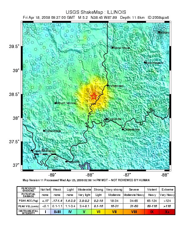
MSV is expected to shake things up with their new satellite, MSV-1, expected to launch in 2009 and based on Boeing’s GeoMobile platform (like Thuraya, but bigger). Wait a minute: where’s California? They have their own earthquake people. But central U.S.? There was an earthquake measuring 5.2 on the Richter Scale in the Wabash Valley on 18 April 2008, via The Southern Illinoisan:

An earthquake centered in southern Illinois rocked people awake across the Midwest early Friday, surprising residents unaccustomed to such seismic activity.

The quake just before 4:37 a.m. was centered 6 miles from West Salem, Ill., and 66 miles west of Evansville, Ind.

Initially pegged as a 5.4 earthquake, the U.S. Geological Survey revised its estimate to give it a value of 5.2.

West Salem is in Edwards County, and dispatcher Lucas Griswold says the sheriff’s department received several calls about the earthquake but only reports of minor damage and no injuries.

“Oh, yeah, I felt it. It was interesting,” Griswold said. “A lot of shaking.”

Meanwhile, on the other side of the world, Australian Broadcasting is reporting a new satellite system for predicting earthquakes using ionospheric dimpling:

The theory suggests that much of earth’s rock has soaked up water, which has later been exposed to extreme heat and pressure inside the earth. Those conditions break apart the water and create the electrically conductive crystals that exist inside most rocks, as well as byproducts such as oxygen.

As pressure builds before an earthquake, the oxygen molecules inside the rocks undergo chemical reactions, creating a positive electrical charge that radiates out toward the earth’s surface.

"It’s similar to how an electrical charge radiates through a battery," says Freund.

The charge creates a subtle fluorescent, infrared glow and a magnetic field one to two weeks before a major earthquake.

That light shines into space, the theory goes, where satellites can register the change.

Low-resolution thermal cameras aboard the proposed satellites would scan the earth to detect earthquake precursors, says Eves.

The positively charged magnet creates a dimple, up to 20 kilometres deep, in the earth’s atmosphere by attracting negatively charged ions from as far away as 600 kilometres above the surface of the Earth.

To detect this ionospheric dimpling, the satellites would monitor the existing Global Positioning Satellite System with three small GPS antennas on its side. As each GPS satellite comes up over the horizon, its signal would pass through the ionosphere. Any dimpling would change that signal.

The theory is not without skeptics.

"As far as I know, there is no published research to suggest that this will work," says Dr Mike Blanpied, who is with the United States Geologic Survey’s Earthquake Hazards Program.

This early-warning system was reported by the Wall Street Journal last month:

Early in May, NASA earth scientists monitoring infrared images of the earth noticed unusual patterns in southwestern China. One sent an email to colleagues, noting: Something is happening in Sichuan province.

For Friedemann Freund, a chemist-turned-NASA geophysics researcher, it was more support for his simple, though hotly contested theory: Earthquakes are the culmination of drawn-out physical processes that can be tracked sometimes more than a week ahead of the main event.
 
The main idea: Rocks put under enough pressure — for example, when tectonic plates shift — turn into batteries. The resulting electrical currents can travel miles into the earth, Dr. Freund says. The infrared images observed by NASA, for example, were concentrated several hundred miles from the epicenter of the roughly 8.0 magnitude earthquake that struck on May 12, killing at least 34,000 people.

Dr. Freund describes his discovery as simple, made at 2 p.m. on a Friday afternoon in early 2005 just before he and his graduate students finished packing up a temporary laboratory they had been using. For experiment No. 167, one for the road, they decided to use a copper contact to test whether a squeezed rock emitted a current. It did.

"This is something that should have been discovered 50 years ago," he said.

Certainly, people have tried. For more than a century, researchers have debated the pursuit of the "holy grail" of earthquake prediction. There is still no widespread support for linking electromagnetic signals, infrared emissions or atmospheric changes to an approaching quake.

Satellites are used to communicate seismic data, and transmitting videos, of course. The prospect of being able to predict such events many days in advance seems like a real possibility. Count on the Smithsonian to present it, probably based on a published piece by Dr. Ouzounov of George Mason University.

Alaskan Business

Wednesday, June 4th, 2008


Out in the bush, you need an airplane to get around effectively. You can get by with a snowmoble in the winter, but how much can you cover in a day? Alaska is a big state, spanning 663,267 square miles (that’s 367 million acres, cowboy). Since the early 1970s, Alaska’s telephone system has been using satellite, primary using AT&T Alascom’s Aurora satellites (currently Aurora III; co-named AMC-8). Pretty extensive network, highlighted by the Alyeska Pipeline:


When Galaxy 18 launched in May, we didn’t think they’d be cutting over some of the services from the Galaxy 10R spacecraft so quickly.  End-of-life for G10R was originally projected to be 2015, but after a XIPS problem, it was cut short. One of the big customers on that bird, GCI, moved nine transponders of traffic yesterday:

GCI announced today that it successfully transitioned all of its rural telecommunication services last night to the Galaxy 18 satellite. This satellite will provide long-distance, Internet, distance education and telehealth services throughout rural Alaska for the next 14 years.

“The success of last night means rural Alaskans will stay connected to the most advanced network in Alaska,” said Ron Duncan, GCI president and CEO. “It also provides major businesses in Alaska and carriers in the lower 48 states the ability to directly touch customers virtually anywhere in Alaska.”

GCI owns nine transponders on Galaxy 18 and will take possession of a tenth transponder in approximately two weeks. GCI will lease the transponder capacity from Intelsat. However, GCI will be required to account for this arrangement as a capital lease. This will result in a capital lease obligation, and corresponding long-term asset, in the approximate amount of $98 million.

Hmm. At that price, it seems to work out to approximately $58,000 per month per transponder, and that ain’t a bad price. I suppose if the oil keeps pumping, there will always be money to pay for satcom services. Keep us rocket scientists busy for years.

Here’s where the oil ends up, in Valdez:


Blogging at 300 KM/H

Monday, June 2nd, 2008

No, the title of this post isn’t a reference to the velocity of our Kerouacian prose — it’s what you could be doing if you took a train between Paris, Brussels, Amsterdam and Cologne:


 The first commercial application of the European Space Agency (ESA) “Broadband on Trains” initiative officially launched May 14 on six high-speed Thalys trains… Passengers on the trains equipped with “Thalysnet” have continuous Internet connectivity while traveling at 300 km/h via a satellite 36,000 km above the trains.

The satellite link uses a low profile tracking antenna on the train to provide a two-way connection to the Ku-band satellite system and a hub station connected to the Internet backbone. Terrestrial wireless is used to maintain a connection when the train is traveling through tunnels. The total bandwidth from the satellite shared among users on the train is 2 Mbps down and 512 Kbps up. Bandwidth across all trains in the fleet is allocated on demand according to the usage level.

The tracking antenna truly is low-profile. If a train passes you at high speed, you’d be hard pressed to see the little nub whizzing by you:


The ESA initiative to bring broadband to trains started nearly two and a half years ago; as of May of this year, Thalysnet is officially and commercially available to train passengers

Thalysnet… was developed by a consortium lead by Nokia Siemens Networks, which combines satellite communications with conventional wireless data technologies to provide a continuous Internet connection on board trains travelling across national borders at 300 km/h. One of the companies in the consortium is the UK-based 21Net, which carried out a pilot project in 2005 under the European Space Agency’s Broadband to Trains initiative.

21Net worked with leading railway operators such as RENFE (Spain) and SNCF (France), along with Thalys, to develop a solution combining bi-directional satellite communications with terrestrial wireless technologies.

With soaring gas prices leading to an increase in public transport usage here in the US, could an American equivalent of Thalysnet be far behind?