If you feel like there is no point to working out — no weight loss, no fun — and if all you enjoy is watching tv, there may be a way to make television your motivation:
Couch Potatoes of the world rise up! (Or at least reach for the remote.) Your nemesis nears. David Butcher is an over 50 year old who has your lazy days in his sights. David has constructed what he labels the ‘Pedal Powered Prime Mover’, and uses it to power all manner of appliances, including the venerable TV. No more loafing about on the sofa watching the tube. David is offering plans, so you can build your own power generator. Got a screwdriver, hacksaw, wrench, hand drill, and wood chisel, plus a spare day? Perfect. A bit of galvanised water pipe, and some particleboard later, you’ll soon be consuming both The Simpsons and calories. David lost 8 lbs over 5 months, pedal powering his own needs. The trick to his design is the huge timber disc, which acts as a flywheel “creating torque where human legs/pedals cannot generate any.” Curious?
Plans for a “pedal powered prime mover” (PPPM) are available for purchase here ($50). They claim it isn’t too tough: “You can assemble the Pedal Powered Prime Mover (PPPM) with standard hand tools (drill, hacksaw, wrench, pliers, screwdriver, etc.). No welding, brazing or machine-shop work is required.”
Instead of using the PPPM to power a battery, you can also connect it directly to you device. They claim that “even the most efficient batteries “lose” 10-15 percent of the power they receive.”
To power a tv?
Our 27 inch television draws 45 watts when the screen is showing a dark picture, and 90 watts when the scene is brightly lit, according to my “Watts-up?” 120 volt AC power meter (same name as the meter on the pedal generator, but it measures AC instead of DC). I’ll bet you never thought of that, but yes, it takes more power to show brightly lit scenes on a television than is does to show dark. If you were pedaling the TV directly, you would have to constantly be adjusting your pedaling speed as the picture changed to keep the voltage at a safe level for the TV.
This isn’t unreasonable. A “sprint” would generate 110 to 150 watts, while a steady ride can generate from 50 to 110 watts.
Why not wash your gym clothes with the PPPM? This user couldn’t quite keep up with the spin cycle.
Conclusion: One person could pedal this machine all the way through the wash. They could not power the spin directly from the Pedal Generator – it just requires too much power. However, with the help of a battery, it would be possible to pedal this washer. In my physical condition, I would have to pedal for about 1 hour and 45 minutes to generate enough power to wash one load.
(There is an explanation at the end of the video.)
Posted in Front Page | Comments Off on DIY Friday: People Powered Prime Mover
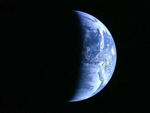
In September, we discussed the launch Japan’s lunar study, KAGUYA – what many consider the most sophisticated lunar exploration mission in the post-Apollo Era. KAGUYA is already showing results, bringing us the first high definition image of Earth (link):
The photograph was taken from a distance of 110,000 km– hundreds of times further away from Earth than any spaceship with similar capabilities had ever been. After taking these breathtaking images, KAGUYA went on to orbit the Moon and then released a baby satellite as part of its ongoing lunar exploration mission.
Until recently there were only three possible ways to photograph Earth from a distance of several hundred kilometers- via a Space Shuttle, via the International Space Station (ISS) or via orbiting satellites. Now, thanks to the KAGUYA Lunar explorer, which was launched by the Japan Aerospace Exploration Agency (JAXA) and the Japan Broadcasting Corporation (NHK), we can see Earth in its full glory, as it is from afar.
In September 2007, JAXA launched the KAGUYA (SELENA: Selenological and Engineering Explorer) into space. It is composed of a main orbiting satellite and two smaller satellites in polar orbit, and is equipped with instruments for scientific investigation of the Moon.
KAGUYA’s (SELENA) main mission is to collect scientific data from the Moon that will be used to explore the possibility of utilizing the Moon in the future. The three HD CCD 2.2 Mega-pixel cameras onboard the KAGUYA were developed by Japan’s Broadcasting Corporation specifically for this mission. In addition to the cameras, the ship is equipped with 13 other scientific instruments which will be used to explore the Moon.
The abovementioned image was processed from a high resolution video that was shot periodically over eight minutes, on September 29th, 2007. When looking at the image, one can see the outlines of the west coast of South America quite distinctively.
This is a still image taken out from the first moving image shooting when the KAGUYA flew from the northern area of the Oceanus Procellarum to the centre of the North Pole. As the altitude near the North Pole is high, the angle of the coming sunlight was lower, thus the shade of the crater topography looks long in the image. The moving image was taken at 4:07 AM on 31 October 2007 (JST) by eight-fold speed intermittent shooting (eight minutes is converged to one minute) from the KAGUYA, and the data was received at the JAXA Usuda Deep Space Centre on the same day.
A video of the moon captured by the HDTV camera is available here.
Describing their mission as a “triple home run,” Discovery’s Commander, Pam Melroy, must have been pretty relieved. From NASA:
The crew of space shuttle Discovery left its mark on the International Space Station during two weeks in space that included adding a new piece, moving another and conducting an unprecedented spacewalk successfully.
“This is truly a triumphant moment for NASA,” Scott Parazynski said. “I think we obtained the summit and then some.”
“When I look back at our mission, it seems like we kind of hit a triple home run,” Commander Pam Melroy said a few hours after landing Discovery at NASA’s Kennedy Space Center on Nov. 7.
The seven astronauts connected a segment called Harmony that will serve as an attachment point for European and Japanese laboratory modules in the next several months. They also moved a tower of electricity producing solar arrays to the far end of the station’s central truss.
The group noticed a tear in one of the blankets as the arrays unfurled, and it took a concerted effort in space and at NASA centers to plan a spacewalk to repair the damage.
“It was an amazing thing to watch a large organization like NASA pivot so easily” to tackle the problem, Melroy said.
Parazynski made the repairs during a spacewalk that called for him to be perched on the end of the long boom normally used to inspect shuttle tiles.
“I had more butterflies than I normally do before an EVA,” Parazynski said. “It was just different than the prior spacewalks that I had done.”
With the repairs completed, the crew was cleared to return to Earth a day later than scheduled, but confident they left the station and its three crew members in good shape for future additions.
“It really was a beautiful moment for NASA,” Melroy said. “What you saw is who we are at NASA.”
Check out NASA’s site for more videos and behind-the-scenes info.
And if you missed the heroics of the spacewalk, watch this news report:
When I was a kid in Brooklyn, we never carried backpacks to school. We had bookbags or even brief cases (plastic Samsonite). Sure, I had a backpack as a boy scout and I did find it convenient for hiking and exploring. But for school? We took public transportation. It was easier to let your book bag rest on the floor, between your feet, rather than taking out some 90-year-old woman while you turn around. In fact, I was six years old and getting on a public bus in Brooklyn — by myself. School was a mile away, too.
Things sure have changed since then. Every kid has a backpack now. One of today’s more popular pre-school cartoon characters, Dora the Explorer, has a talking backpack. Parents don’t let little kids out of their sight for a moment. Grown-ups now carry their laptops in backpacks to work. Hikers’ backpack are super high-tech: some generate electricity as you walk.
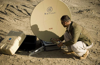
But by far the coolest is a complete satcom terminal — an ultra-portable from Norsat — that fits into two backpacks and can be checked as luggage on most commercial airlines:
The GLOBETrekker is particularly well suited for "grab-and-go" applications and "temporary situations" — wherein broadband communications need to be initiated quickly and on very short notice or on a temporary basis. Its ergonomically designed backpack and overall "quick-connect" design enables users to transport, assemble, operate and disassemble quickly and discreetly. This is particularly appealing to journalists, disaster relief agencies, the military and first responders — all of which are often given very short notice of an impending assignment. This is also of interest to companies seeking an emergency backup system or VIPs seeking to establish a reliable broadband connection while they are traveling.
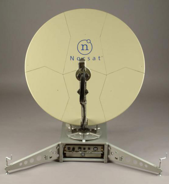
The GLOBETrekker is equipped with sophisticated "built-in" intelligence. The GLOBETrekker’s Sensor Driven System Manager is housed in a single board computer, which acts as the nerve center of the entire system. It continuously monitors the internal environment of the system and automatically counters harsh weather elements (extreme temperatures, sand and humidity) by engaging built-in defenses.
This latest addition to Norsat’s product portfolio has been designed to withstand harsh transport and operating conditions. The GLOBETrekker sports three physical layers of protection including a hard shell exterior, shock absorbing foam inserts and shock-mounted baseband.
The GLOBETrekker supports data transmission rates of up to four megabits per second. It is capable of operating on multiple bands, including the Ku, Ka and X bands. The GLOBETrekker is a highly integrated system which includes a 1m carbon fiber antenna, RF electronics, motorized azimuth/elevation superstructure, motorized feed assembly, built-in inclinometer, compass, GPS and a baseband unit with a modem, spectrum analyzer, DVB-S receiver, Ethernet switch, DC-DC converter and shock protected chassis.
The European Patent Office notified the company that it intends to grant the patent for the technology, which reduces the weight and footprint of transmit reject filters, one of several elements of the RF transmit chain.
"This patent award is part of our broader and long-term strategy to establish a leadership role in the design, development and marketing of portable satellite terminals," Amiee Chan, president and CEO, Norsat International, said in a statement. "Our frequency selective surface waveguide filter, protected under this patent, allows the weight of transmit reject filters to be reduced 50-fold, significantly decreasing the occupied volume. This is a function that is especially useful for the next generation of milsatcom terminals."
In Geneva, Switzerland, the World Radiocommunication Conference 2007 is currently underway — and at the center of the discussions is the future of C-Band (known colloquially as the "compromise band").
C-band is characterized by larger antennas and is preferred by a variety of full-time service providers. C-band is a portion of electromagnetic spectrum in the microwave range of frequencies ranging from 4 to 6 GHz — normally downlink 3.7–4.2 GHz, uplink 5.9–6.4 GHz.
During the first week of the World Radiocommunication Conference (WRC-07), administrations from Asia, Africa, and Latin America made clear their broad and deep support for keeping the status quo for satellite services by calling for no change to the current use of the C band. This campaign, which exhorts the Conference not to identify international mobile telecommunications (IMT) systems in C-band has been gathering pace throughout the past year, driven by both national policy imperatives and the satellite industry.
In the weeks prior to the meeting, the number of countries expressing positions in support of protecting C-band for satellite use outnumbered those in favor of identifying C-band for IMT. Since the opening of the conference, support for protection of the whole band for satellite services has increased in strength from an already solid base. Governments have been assisted by the argumentation of regional and international satellite operators, spearheaded by SES Global, Inmarsat and Intelsat as well as regional operators such as Arabsat and Rascom, and network integrators such as Schlumberger, which all attended the WRC to rally their constituencies.
Advocates of no change in C-band allocations have come from many parts of the world, each with their particular reasons for supporting the position. These include concerns based on pre-existing interference between IMT-like technologies and satellite services which have, in some examples, ruptured Interpol’s communications in Gambia and caused severe problems to Bolivia’s direct-to-home satellite services during the 2006 FIFA World Cup. African governments have been at pains to emphasise the importance of C-band in areas that experience rain fade and the risk to satellite services if neighboring countries were to implement IMT. Asian governments, in clear allusions to recent tsunamis, have emphasised the role of satellite communications in disaster and emergency circumstances, as well as the growing demand for those services
Archived audio feeds of the discussion can be found here.
During the first week and a half of the 2007 World Radio Conference in Geneva, some 3000 attendees were given an opportunity to see how Radio Amateurs can provide Emergency and Disaster communications. A van, constructed and manned by German Radio amateurs, was parked in front of the main entrance of the conference centre for delegates to visit. IARU Emergency Communications coordinator Hans Zimmerman F5VKP also participated in the demonstration. The IARU flag was flown at the top of van’s extendable mast.
José Albuquerque, the Senior Director of Spectrum Engineering at Intelsat, also makes the case for C-Band:
Currently, there are some 160 satellites in the geostationary orbit using C-band frequencies for their downlink transmissions (see Figure 1). This is the equivalent of more than 3000 satellite transponders with a 36 MHz bandwidth with the potential for transmitting about 180 Gbit/s at any given instant. This infrastructure represents an investment in excess of USD 30 billion in spacecraft and launch costs alone, without taking into account investment in the ground segment made by users and satellite operators.
Deployment of IMT systems in these frequencies would drastically reduce the benefits that these resources have brought to users around the world, because fixed-satellite services and IMT systems cannot share frequencies in the same geographic area.
C-band frequencies are used for downlink satellite transmissions that provide a wide range of services in developed and developing countries, including critical applications such as distance learning, telemedicine and universal access services; backhaul services (telephony, Internet); very small aperture terminal (VSAT) data links such as bank transactions or corporate networks; distribution of television programmes; mobile-satellite service feeder links, and emergency links, including disaster recovery services and meteorological tracking. These services require the high reliability and broad geographic coverage that can only be delivered in the C-band….
It is not feasible to undertake co-frequency operation of FSS receiving Earth stations and transmitting fixed or mobile stations in IMT systems. ITU–R studies have concluded that separation distances of between tens of kilometres and a few hundred are required to ensure protection of FSS Earth stations. Considering that a typical city covers an area with radius of between 15 and 30 km, sharing between IMT systems and FSS receiving Earth stations is not realistic.
In addition, IMT transmitters can also interfere with FSS Earth stations operating in adjacent bands. Unwanted emissions generated by IMT transmitters falling within the FSS desired signal cannot be filtered and will therefore generate interference. Furthermore, signals generated by an IMT transmitter can be strong enough to saturate the low-noise amplifier (LNA) of the FSS receiver. In view of the significant difference between the levels of the desired signal (originating at the satellite transmitter about 36 000 km away) and the interfering signal (originating at the IMT transmitter only a few kilometres away), filtering the IMT signal to the required levels might become unfeasible.
The adjacent-band interference effects described above highlight the fact that identification of a portion of C-band frequencies for IMT systems, while keeping another contiguous portion for FSS use, is not free of interference problems and does not constitute a desirable approach.
Would it be a bad pun to call this a major milestone?
This past weekend, 11 finalists for the DARPA Urban Challenge — a prize competition for driverless cars — wove their way through a 60-mile course at the U.S. Army urban warfare training center in Victorville, California (formerly the housing area at the now-closed George Air Force Base).
Only 6 teams finished, with Carnegie Mellon’s Tartan Racing Team taking the $2 million development prize. Defense Industry Daily was there, and has some amazing reporting:
[DARPA had the] guts to invite in the world press and the general public while trying something new to the world: Turning multiple autonomous vehicles loose on city streets at the same time, interspersed with human drivers. As [DARPA Director Dr. Tony] Tether said at the start of the program, "If anyone tells you he knows what’s going to happen, he’s lying."
Since that test could likely take every bit of a short November day, the teams, staff and press assembled for their briefings at a chilly and dark 0600 hours. The day featured robot traffic jams, the world’s first ‘bot vs. ‘bot collision, and the Terramax robot truck’s attempt to take out the old air base PX.
The competitor autonomous vehicles had to obey California traffic laws and were penalized for any violations. The three top teams had no infractions and were thus ranked solely by time in completing each of three "missions"—coming in with total times staggered by intervals of about twenty minutes. In addition to the robots, nearly 50 vehicles with professional drivers were on the course at the same time to simulate traffic situations.
The competition was close — Carnegie Mellon won with an average 14 mph throughout the course, while the second and third place finishers (Stanford and Virginia Tech, respectively) averaged just about and just under 13 mph. All of the top 3 teams finished the course in less than 6 hours. (MIT came in fourth place.)
Tether couldn’t have been more pleased with the race, calling it a "fantastic accomplishment," and saying that the technology for robotic vehicles was now just about ready for other companies and organizations to pick up the work in honing it further. "DARPA is an interesting organization," he said. "We really never finish anything. All we really do is show that it can be done. We take the technical excuse off the table, to the point where other people can no longer say ‘Hey this is a very interesting idea, but you know that you can’t do it.’ I think that we’re close to that point, that it’s time for this technology to [be furthered] by somebody else."
While five teams didn’t make it to the finish of the course (due to several "vehicle vs. building incidents"), there were no reports (that we’ve heard) of bot road rage.
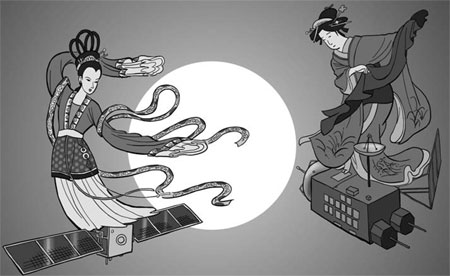
A Chinese satellite successfully entered lunar orbit Monday, a month after Japan put its own probe into orbit around the moon, the AP reports:
Chinese space officials said the Chang’e 1 satellite, part of the country’s ambitious space exploration plans, entered lunar orbit after completing a planned braking operation.
China plans to keep the Chang’e 1 – named after a mythical Chinese goddess who flew to the moon – there for one year, about the same length of time as Japan’s probe. China launched its satellite late last month, while Japan put its into space in September.
The timing of the launches raises the prospect of a space rivalry between the two Asian nations, with India possibly joining in if it carries through on a plan to send its own lunar probe into space in April.
We blogged about the Japanese lunar probe when it launched in September. Meanwhile, back at the 73rd annual meeting of the Indian Academy of Sciences, the lunar probe referenced above is indeed planned for April, 2008, with more missions to follow:
Work on Chandrayaan-1, India’s first lunar probe, was progressing, said J.N. Goswami, Director, Physical Research Laboratory, Ahmedabad. The plan was to launch the spacecraft around April 2008.
Planning for the follow-on mission had started, he said. Apart from an orbiter that would circle the moon, Chandrayaan-2 could also have a soft-lander carrying a robotic rover.
A slide projected by Dr. Goswami during his talk indicated that the Chandrayaan-2 mission could take place around 2011-12.
Wikipedia has some good information on Chandrayaan.
So is this the beginning of an Asian space race? Here’s an opinion piece from Japan, translated into English and published in the China Daily, which argues that China is way ahead of the game:
China already has a high level of space technology. It has launched more than 100 Long March rockets since 1970, while Japan’s H2-A rocket has been launched only 13 times…..
[Now], China’s space development has drastically accelerated. Starting with the launch of the orbiter, China’s lunar exploration program comprises a moon landing and deployment of a moon rover with the retrieval of lunar soil and stone samples. China also aims to advance its technologies for manned spacecraft.
Further, it is moving forward with projects to launch a reconnaissance satellite and another one for its own global positioning system.
In addition, China is launching communication satellites for Venezuela, Brazil and Nigeria, and also received an order from France to launch a communication satellite, showing the commercial success of its program.
China has voiced a strong desire to participate in the International Space Station (ISS) program in which Japan is involved and the United States and Russia play pivotal roles.
Some observers say that in the near future China will become one of the world’s leading nations in the field of space development, equivalent to the United States and Russia.
In contrast, Japan’s space program, despite its successful development of the H2-A rocket, lacks specific targets – including what type of satellite it will launch in the future – due to budget woes.
Surfing at East Java. This brings two things to mind – boarding off the coast of Indonesia and surfing the Internet at a trendy coffee shop. But what if you want to surf the Internet in Indonesia. Well, its not so easy.
Indonesia is a developing nation consisting of 17,508 islands, making it the world’s largest archipelagic state. Indonesia also happens to be the fourth most populous country in the world. So how do you connect all these Islands and people? With SAT-GE:
SAT-GE, a provider of unique C and Ku-band satellite coverage stretching across the Pacific Ocean Region from coast-to-coast, today announced the provision of satellite capacity across Eastern Indonesia for PT Telkom, the leading incumbent telecommunications operator in Indonesia.
Using multiple transponders on the GE-23 satellite, PT Telkom are able to rapidly extend their GSM/CDMA network and other services over Eastern Indonesia, providing connectivity deep into Papua, Maluku and Sulawesi.
GE-23 was chosen as the best satellite for the job, with a prime position over Papua, it delivers a unique coverage of Eastern Indonesia and its power capability is ideal for high bandwidth trunking and backhaul.
“With a subscriber base growing at double digits month-on-month, we needed a combination of bandwidth, coverage and rapid deployment. Satellite was the ideal solution for our expansion in Eastern Indonesia, and GE-23 meets our needs,” said Mr Dani Indra Widjanarko – Satellite General Manager.
“It has been a pleasure to work with SAT-GE; their responsiveness and the higher power capability of GE-23 opens many opportunities for us for Eastern Indonesia.”
Andrew Jordan, General Manager of SAT-GE, commented: “We are delighted to be able to assist PT Telkom in their pursuit of growth and the roll-out of communications across Indonesia. GE-23 supports voice, video and data applications and PT Telkom has chosen a platform that will be able to grow with their objectives and aspirations.”
PT Telekomunikasi Indonesia Tbk (TELKOM) is the largest full information and communications (InfoComm) service and network provider in Indonesia. TELKOM (here after referred to also as the Company) provide fixed wirelines, fixed wireless, cellular as well as data & Internet and network interconnection services, both directly and through its associate companies and subsidiaries.
As of December 31, 2006, the number of TELKOM subscribers reached 48.5 million, consisting of 8.7 million fixed wireline and 4.2 million fixed wireless subscribers and 35.6 million cellular subscribers. TELKOM’s subscriber growth of 30.73% in 2006 increased the Company’s operating income in 2006 by 23% compared to that of 2005.
Focus. It can be tough to get “in the zone” at work. AIM windows popping, email alerts, Really Rocket Science RSS feeds — is there ever a break for work?
Forget about server-side firewalls — its time for an office firewall:
The recipe is pretty simple: turn off your programs, put AIM on away, don’t open a browser, and tell your co-workers to bugg-off.
But some of this is just a little ridiculous:
If interruption by your manager or co-workers is a big problem, work out a way that you can signal you’re available to chat or that you’re super-involved at the moment at your desk. A dishwasher “dishes are clean, dishes are dirty” flippy sign comes to mind, or a mailbox flag type device. Make an agreement with others that when the “sock’s on the door,” you won’t stop by asking if they want to get coffee or what they thought of last night’s Lost.
While some of this is just genius:
A couple of programmers I know who worked at a frenetic office used to schedule a 2 hour long meeting together in a conference room a couple of times a week, where they’d go with their laptops to code in peace.
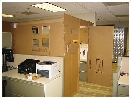
But maybe we need more dramatic change. Designer Marcus Curran developed an office “pod”:
If your manager isn’t going to sign-off on that price-tag, just turn to cardboard:
Or, best of all, don’t go to the office at all. The new trend may be telepresence:
It’s IvanAnywhere, a robot Bowman uses to interact with his colleagues in Waterloo from his home office 1,350 kilometres away.
“Robot” is a bit of a stretch, actually. IvanAnywhere is basically a coat rack on wheels with attached speakers, camera and touch-screen computer.
The computer screen displays a live shot of Bowman’s face from his living room in Nova Scotia.
But in the three months since IvanAnywhere first went online, he has become such a normal part of the third floor at iAnywhere that co-workers barely even notice they’re talking to a machine rather than to Bowman’s human form.
“We are all so used to Ivan, they don’t even give it a second thought,” says Glenn Paulley, Bowman’s boss and the originator of the IvanAnywhere idea.
When Bowman has a question for a colleague, he doesn’t pick up the phone; he uses his joystick to drive his doppelganger to the team member’s office.
If Paulley needs Bowman’s time on a software issue, he calls IvanAnywhere to his office, just as he would with any other employee.
Bowman uses IvanAnywhere to take part in meetings, even giving presentations with the help of a projector.
Every once in a while, he’ll motor to the floor’s lounge area to look out the window and chat with passersby, much as he would if he were in Waterloo.
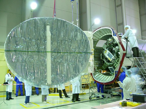
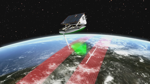
The SAR-Lupe satellite was launched via a Kosmos-3M rocket from the Plesetsk Cosmodrome in Russia earlier this morning. Built by OHB-System AG in Germany ("lupe" is German for magnifying glass; SAR = synthetic aperture radar), the satellite will be used for earth observation, day or night, in any weather condition — according to Wikipedia:
They use an X-band radar with a three-metre dish, providing a resolution of about 50 centimetres over a frame size of 5.5km on a side (‘spotlight mode’, in which the satellite rotates to keep the dish pointed at a single target) or about one metre over a frame size of 8km x 60km (‘stripmap mode’, in which the satellite maintains a fixed orientation over the earth and the radar image is formed simply by the satellite’s motion along its orbit). Response time for imaging of a given area is 10 hours or less.
Satellites as carriers of optical or radar sensors can, unlike aircraft or unmanned aerial vehicles, carry out reconnaissance operations without infringing sovereign rights. They are thus particularly suited to gather information – without escalating effect – about early crisis detection and prevention and about effective crisis management.