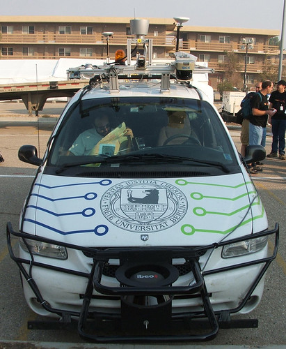
The team developed its iDriver app to manage the highly modified "Spirit of Berlin" autonomous vehicle using WiFi and the smartphone’s controls. The unit’s accelerometer controls steering, accomplished at hand by turning the device, while screen buttons control braking and acceleration. The system also sends a live video stream of the road ahead to the iPhone screen.
The van can also drive itself, by way of technologies developed for the 2007 DARPA Urban Grand Challenge autonomous vehicle race (the van was their entry). Packed inside are a stack of IBM Blade servers, video cameras, 3D laser sensors and GPS for positioning, as well as the drive-by-wire system that enables the iDriver app’s functionality. In one experiment, a team member reportedly sat on the roof rack and steered the vehicle from above.
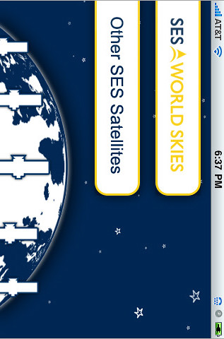
Want to find out a particular satellite’s C-band coverage? There’s an app for that.
Commercial satellite operator SES World Skies published an iPhone app last month. Who knew? No "press release" or splashy introduction on their Web site. So while I was at the SATCON Expo show in New York yesterday, and bada-bing: SES is showing an app in their booth.
OK, let me check it out…
The app is called "SES World Skies" and apparently is the first of its kind. No other "satellite coverage" app exists, so they got that going for them.
First of all, it uses 30 MB and only works in the horizontal position. Google Earth is 8.9 MB. Well, that’s not good. The description is the company’s standard boilerplate:
SES WORLD SKIES is the new global division of SES, created through the combination of the former SES NEW SKIES and SES AMERICOM. The company operates a fleet of 25 satellites – part of the 40 spacecraft of the SES group – delivering services as diverse as television distribution and broadcast, internet access, data transmission and business and government communications to customers worldwide. SES WORLD SKIES currently has six additional satellites under construction. The company’s unique customer-focused approach allows it to offer the best satellite solution for a host of business and government requirements, with a view toward helping customers meet their short-term challenges and realize their longer-term goals. SES WORLD SKIES comprises a world-class team of customer care and technical professionals located in Princeton (NJ), The Hague, Washington D.C., Singapore, Beijing, London, Sao Paulo, Mexico City, Sydney, Accra and Johannesburg. Visit www.ses.com for more information.
WTF? This is enough to get me to download? OK, so it’s free. How do I use it? Nevermind, just start tapping. I did eventually find the instructions page (misspelled, too).
It shows basic, general coverage of each satellite, and lists the general specifications. Does it take advantage of the iPhone’s GPS? No. Can you type in your location and see what satellites are available? No. Can you contact a local sales office for a particular satellite? No. Can you check whether inventory is available for a 4-hour sporting event? No.
SES would have been better off collaborating with DishPointer and building a really good app that promotes their business in general and adds value to the customer experience in particular. In fact, you should check out DishPointer’s app. It rocks. Check out the Augmented Reality Pro version — a steal at $20. Here’s a demo video…
The SES app, unfortunately, won’t be found on many "best iPhone apps" lists any time soon.
Since we like our original ringtone, we naturally take notice whenever we come across other distinct ringtones. The G20 "riot control" people in Pittsburgh took to using the LRAD (Long-Range Acoustic Device) — a directed acoustic device:
LRAD® (Long Range Acoustic Device™) is a breakthrough hailing and warning, directed acoustic device designed to communicate with authority and exceptionally high intelligibility.
What makes the LRAD product unique is its ability to transmit your message with exceptional voice intelligibility and tonal clarity in a highly directional beam, even with significant ambient noise. The directionality of the LRAD device reduces the risk of exposing nearby personnel or peripheral bystanders to harmful audio levels.
Think it would make a cool ringtone? We do. That’s just what T. Foley of Pittsburgh did via Locally Toned:
The sound made by the Long-Range Acoustic Device (LRAD) or sonic canon fired by police during the G20 protests in Pittsburgh on September 24, 2009. I dropped the audio level a bit, took one “firing” of the device from the original audio Carl Cimini shared with Locally Toned, and looped it together to make this short and piercing tone.
I don’t know about you, but I suspect people around you will prompt you to answer your mobile quickly when it rings.
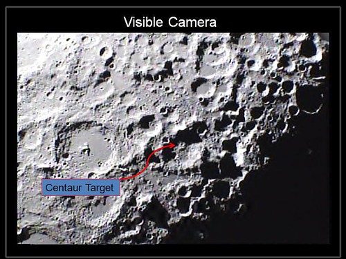
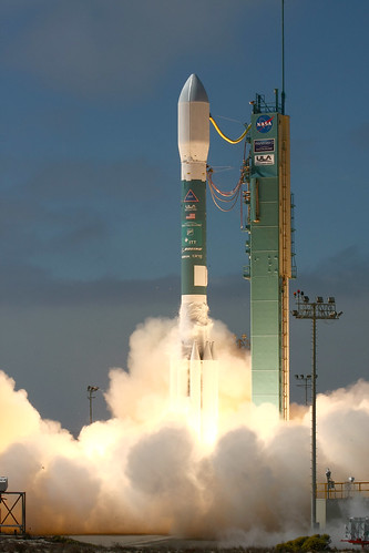
NASA’s Lunar Crater Observation and Sensing Satellite, or LCROSS, created twin impacts on the moon’s surface early Friday in a search for water ice. Scientists will analyze data from the spacecraft’s instruments to assess whether water ice is present.
The satellite traveled 5.6 million miles during an historic 113-day mission that ended in the Cabeus crater, a permanently shadowed region near the moon’s south pole. The spacecraft was launched June 18 as a companion mission to the Lunar Reconnaissance Orbiter from NASA’s Kennedy Space Center in Florida.
"The LCROSS science instruments worked exceedingly well and returned a wealth of data that will greatly improve our understanding of our closest celestial neighbor," said Anthony Colaprete, LCROSS principal investigator and project scientist at NASA’s Ames Research Center in Moffett Field, Calif. "The team is excited to dive into data."
In preparation for impact, LCROSS and its spent Centaur upper stage rocket separated about 54,000 miles above the surface of the moon on Thursday at approximately 6:50 p.m. PDT.
Moving at a speed of more than 1.5 miles per second, the Centaur hit the lunar surface shortly after 4:31 a.m. Oct. 9, creating an impact that instruments aboard LCROSS observed for approximately four minutes. LCROSS then impacted the surface at approximately 4:36 a.m.
"This is a great day for science and exploration," said Doug Cooke, associate administrator for the Exploration Systems Mission Directorate at NASA Headquarters in Washington. "The LCROSS data should prove to be an impressive addition to the tremendous leaps in knowledge about the moon that have been achieved in recent weeks. I want to congratulate the LCROSS team for their tremendous achievement in development of this low cost spacecraft and for their perseverance through a number of difficult technical and operational challenges."
Other observatories reported capturing both impacts. The data will be shared with the LCROSS science team for analysis. The LCROSS team expects it to take several weeks of analysis before it can make a definitive assessment of the presence or absence of water ice.
"I am very proud of the success of this LCROSS mission team," said Daniel Andrews, LCROSS project manager at Ames. "Whenever this team would hit a roadblock, it conceived a clever work-around allowing us to push forward with a successful mission."
Viasat receives $46M contract from Star Satellite Communications Company, a subsidiary of Yahsat, for network infrastructure and customer premise terminals for new high-speed internet service in Middle East, Africa, and Southwest Asia. [socalTECH – 10/08/2009]
Lunar Crater Observation and Sensing Satellite to image impact of its empty upper stage before the satellite also crashes into the moon; studies of plume of gas and dust may confirm presence of ice. [SatNews – 10/08/2009]
SpeedCast and Eutelsat expand coverage of their maritime solution across the Atlantic Ocean and the Americas. [Satellite Today – 10/08/2009]
Omnicity Corp signs agreement with StarBand Communications to offer StarBand satellite high speed internet service in Omnicity markets throughout the U.S. [SatNews – 10/08/2009]
KT Corporation signs multi-year pre-launch contract for capacity on Intelsat 17 satellite to be launched in 2011, to deliver enhanced broadband VSAT services in Asia, Africa, and Middle East. [SatNews – 10/08/2009]
TDM Satellite Channel, Macau, begins free to air broadcasting on newly launched AsiaSat 5 satellite serving more than 50 countries in Asia Pacific. [SatNews – 10/08/2009]
Inmarsat and Vizada donate 70 BGAN terminals to ITU in agreement to improve emergency communications for disaster preparedness and coordinate relief activities. [SatNews – 10/08/2009]
RapidEye supplies German company EOMAP with satellite imagery to support mapping services for oil spill monitoring in Australia. [SatNews – 10/08/2009]
UTV signs contract for capacity on MEASAT-3a for carriage of UTV Movies. [SatNews – 10/08/2009]
Cable & Wireless Panama chooses Gilat to provide SkyEdge II high-performance network to deliver broadband internet to hundreds of schools in remote areas nationwide. [SatNews – 10/08/2009]
ExactEarth, subsidiary of COM DEV International, successfully uses NanoSat Automatic Identification System technology to help Canadian Forces monitor illegal fishing activity in Pacific. [SatNews – 10/07/2009]
Iridium is staging a comeback, goes public 10 years after chapter 11 bankruptcy; can Pentagon demand and other niche services including hosted payload keep it going as it faces satellite replacement requirements? [BusinessWeek – 10/06/2009]
ORBCOMM and Sierra Wireless enter agreement to integrate Sierra Wireless’s M2M services platform within ORBCOMM’s satellite web services portal. [TMCnet – 10/05/2009]
Harris subsidiary Maritime Communication Services launches iDirect Evolution network to support broadband IP services for its maritime customer Carnival Corporation. [PRNewswire – 10/06/2009]
China’s late September announcements that it will build and launch communications satellites for Bolivia and Laos may be followed by plans to build satellites for Ecuador, Myanmar, and Vietnam, as well as some African countries. [AsiaTimes – 10/07/2009]
NSR free webinar will discuss the coming surge in launches of satellites for the mobile satellite services sector – three LEO constellations totaling 128 satellites and another 23 MEO and GEO satellites could be launched in next six years – market demand equation will tilt strongly toward supply side. [NSR free webinar – October 20, 2009]
In the midst of a barrage (literally) of fall phone announcements, AT&T and TerreStar managed to stand apart from the pack on Wednesday with their announcement of an integrated cellular satellite smartphone. The TerreStar Genus will use AT&T’s network, but will also be able to access an all-IP satellite service when cellular coverage isn’t available. You’ll be able to use the phone in the United States, Puerto Rico, the U.S. Virgin Islands, and coastal waters.
With a QWERTY keyboard and a candy bar design, the Genus resembles many a Windows Mobile device (it runs the same OS). Feature details ares slim at this point, but we know that the handset will offer Bluetooth, a touch screen, Wi-Fi, and GPS. Pricing is to be announced, though the Genus will only be released to government customers. Phone Scoop says that AT&T is working on a consumer variant as well.
It runs Windows Mobile. *yawn* Even Blackberry is better than WinMo.
You know, I don’t care for it. Would I want satcom back-up? Yes. Give up my iPhone? No. Wait a minute…
Now that’s a hot idea: build the satcom capability into an iPhone. Now that’s a good enhancement. Might as well add a special feature: bypassing Edge service and connecting directly to satellite. I’d pay extra for that.
Thales Alenia Space signs contract with APT Satellite Company Limited to design and build APSTAR 7, to provide broadcasting and communications services over the Asia Pacific, Africa, Middle East, and part of Europe. [SatNews – 10/01/2009]
Ariane 5 delivers two payloads to orbit; Amazonas 2 for Spain’s HISPASAT, the COMSATBw-1 for Germany. [SatNews – 10/01/2009]
EGNOS, a free satellite navigation network, is launched by the European Union, intended to help pilots, drivers, and blind people by fine tuning GPS accuracy to within 2 meters.. [SatNews – 10/01/2009]
Comtech EFData gets $1.1M order from U.S. government for equipment to support the government’s satellite-based communications infrastructure. [Newsday – 10/01/2009]
TeleCommunications Systems gets $11.7M contract from U.S. Army to provide additional Secret Internet Protocal Router and Non-secure Int ernet Protocal Router FSAT systems to the United States Forces Afghanistan. [Sys-Con – 10/01/2009]
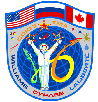
Soyuz TMA-16 launch carries Jeffrey Williams and Maxim Suraev of the 21st space station crew into space for a six month stay aboard the International Space Station. [SatNews – 09/30/2009]
B-52 bombers will be getting a new satellite communications system, to be developed and installed by Boeing. [Minot Daily News – 09/30/2009]
NSS-12 satellite, the first satellite built by Space Systems/Loral for SES NEW SKIES, is delivered to Kourou launch base for October 29 scheduled launch. [TMCnet – 09/30/2009]
THOR 6, aTelenor’s latest satellite, arrives safely at Guiana Spaceport In Kourou for scheduled end of October launch. [SatNews – 09/29/2009]
Terrestar will be able to deliver the most advanced communications services over a large area using a single satellite instead of multiple satellites using 18-meter antenna deflector built and successfully deployed by Harris. [TMCnet -09/29/2009]
KVH TracPhone FleetBroadband systems receive new "505" emergency calling service which routes calls directly to Coast Guard rescue centers worldwide. [PRNewswire – 09/28/2009]
China plans to build and launch a communications satellite for Laos. [RedOrbit – 09/27/2009]
ViaSat will pay $443 million cash and use $125 million of newly issued ViaSat shares to buy WildBlue. The cash flow from each company is expected to cover financing for the transaction.
Liberty Media will appoint a board member to ViaSat as part of the acquisition.
WildBlue’s other shareholders include Intelsat, Tennenbaum Capital Partners, the National Rural Telecommunications Cooperative, and Kleiner Perkins Caufield & Byers.
ViaSat technology helps power the WildBlue service already, and the two companies have worked together for more than a decade. ViaSat CEO Mark Dankberg said the company will launch a satellite, ViaSat1, in 2011 that will allow for a major expansion in the number of customers WildBlue can serve.
WildBlue CEO David Leonard agreed in a written statement about the deal.
“With the addition of ViaSat-1 capacity to our network, we believe we can grow our subscriber base to become a top 10 broadband ISP in the U.S. and expand further domestically and internationally,” he said.
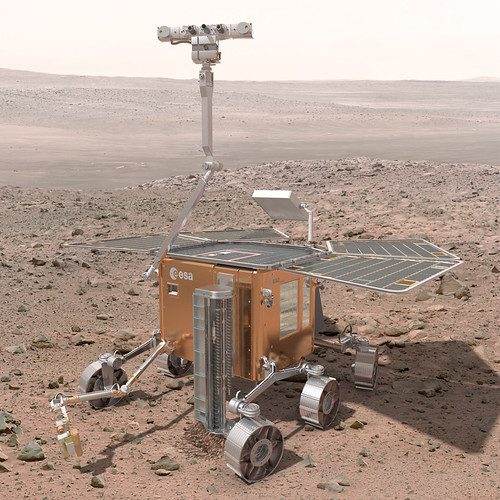
The quarry – chosen for its similarity to Martian terrain – saw cameras and image processing software tested on the ExoMars prototype rover Bridget.
The rover will be equipped with a raft of cameras and the aim is to integrate them and the data they will send back.
The technology developed for the mission has applications not only in space science but also here on Earth.
The eventual rover will have a pair of front-mounted navigation cameras and a quartet of cameras at its corners for hazard avoidance.
It will also have a pair of scientific cameras that give it stereoscopic vision and thus depth perception, as well as a high-resolution camera for zooming in on areas of interest.
The wide-angle scientific cameras are equipped with filter wheels, which limit the light that reaches them to specific wavelengths.
Measuring the sunlight reflected off Martian terrain in these specific bands gives information on the chemical makeup of whatever is in the field of view.
The aim of the EU PRoVisG (Planetary Robotics Vision Ground Processing) project is to stitch together all of the information from the cameras, ensuring for example that the scientific results are tagged to the location at which they were taken and that the navigation cameras’ views are assembled into a virtual, 3D representation of the rover’s environment.
What are they looking for? Plenty:
The ExoMars mission’s scientific objectives, in order of priority, are:
To search for signs of past and present life on Mars. » Read more…
To characterise the water/geochemical distribution as a function of depth in the shallow subsurface.
To study the surface environment and identify hazards to future human missions.
To investigate the planet’s subsurface and deep interior to better understand the evolution and habitability of Mars.