Isolation has been among the defining characteristics of maritime travel ever since man first crossed the oceans in primitive boats. Once you left shore, there was no way to reach those still on land until the journey was over.
Radio, of course, changed that, though it was not until the advent of satcom that true global connectivity became available. And today the progression of maritime communications continues with the introduction of seamless global roaming for data and voice communications at sea.
A truly seamless system would give each ship a direct phone number that would work anywhere in the world — meaning you could call, say, the rower of the Zeeman Ocean Challenge to say, "How are your arms feeling now?"
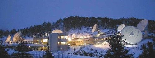
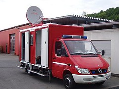
Telenor (whose Eik teleport station in Norway, which provides telecom services to the the North Sea, is pictured above) has just unveiled their product to reach a marketplace that is literally oceans-wide:
OceanRoam™ will provide vessels worldwide Internet and telephone connectivity around-the-clock using the ships’ assigned IP addresses and telephone numbers regardless of location. Telenor’s OceanRoam will offer “always-on” Internet access and IP-based service at a fixed monthly price. The service will enable voice services and unlimited data transfer for ship’s business and crew communications and will feature a variety of committed information rate (CIR) service levels up to 128 kbps. Additionally, OceanRoam will meet vessels’ communications requirements for bandwidth intensive applications, such as video conferencing and large data transfers, by providing a series of optional bandwidth on demand information rates of up to 1024 kbps.
(Note that the Director of Media and Public Relations is named, appropriately enough, Tom Surface.)
We haven’t quite delved into the details of how OceanRoam differs from another Telenor product, WaveCall, but Alan Spicer runs a good blog on marine telecom that provides in-depth analysis of products and trends for those interested in following the maritime space (no pun intended) more closely. DigitalShip is also a good resource for tracking the convergence of IP, satcom, and other communications platforms in the maritime marketplace.
Two Ottawa-based satellite companies have awarded a total of 12 licences by the federal government to launch new satellites to improve broadcasting and telecommunications services to Canadian entrepreneurs and customers.
The Honourable Maxime Bernier, Minister of Industry, today announced the results of a licensing initiative to authorize the development of new Canadian satellites that will increase and improve broadcasting and telecommunications services to Canadian entrepreneurs and consumers. The first satellites are expected to provide services as early as 2010.
"Canada needs to increase its satellite capacity to keep pace with the ever-increasing demand for satellite services," said Minister Bernier. "By awarding these new licences, we are helping the expansion of satellite capacity and services that will benefit Canadians for years to come. We’re helping to foster an environment that will bring all the benefits of competition, including increased product and service offerings, choice in supplier, competitive prices and export revenues."
Canadian satellite operators Ciel Satellite LP and Telesat Canada have indicated their intention to invest several billion dollars in building and launching new Canadian satellites, which will provide the capacity needed to fully implement high-definition television in Canada and carry important new and advanced telecommunications services such as satellite Internet. These new satellites will also help connect all regions of Canada, especially in the North, where satellites are the vital link to providing public safety, national security and government services. This process represented the largest spectrum licensing initiative ever undertaken in Canada and will lead to Canadian consumers and businesses gaining access to emerging satellite broadcasting and telecommunications services such as high-definition TV, Internet Protocol Television (IPTV), satellite broadband and multimedia consumer applications.
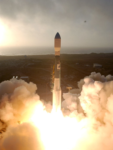
"It is very emotional," said a tearful Francesca Sette, Thales Alenia Space-Italia. "We worked very hard for six months on this event; and during the last six months, we began to work 24 hours per day to ensure we completed this project on time."
The group from the Italian launch community used the Pacific Coast Club here to observe the event. An extravagant event, it included everything from 30 plasma screen TVs, to a live broadcast from Rome with a speech by Italian Minister of Defense, Arturo Parisi.
After watching the rocket lifting off the pad during a live broadcast in the PCC, an Italian train of 100 people went hurrying through the door to observe the Delta II rocketing through the sky outside. People were jumping up and down and hugging each other in celebration.
"It was so beautiful," said Mara Midealo, the wife of a Thales Alenia employee. "This was my first launch and it was a great event."
Thales Alenia Space Italia developed the COSMO-Skymed program for Agenzia Spaziale Italiana, using an X-band Synthetic Aperture Radar instrument. More about the mission:
The Cosmo-Skymed satellites are intended to provide monitoring, surveillance and intelligence data during international crisis for military customers, and environmental surveillance of floods, fires, landslides, and oil spill as well as earth topographic mapping, law enforcement for commercial, civilian institutions and scientific communities. Each satellite will be equipped with one X-band multipolarimetric Synthetic Aperture Radar (SAR) that will provide coverage of areas with a maximum width of up to 520 km.
The Cosmo-Skymed satellites will provide high resolution metric and sub-metric imagery through clouds, at night, with a revisit time of few hours. The 4 satellites constellation will acquire and furnish data worldwide.
The SAR sensor can work in four acquisition modes. Using the SPOTLIGHT mode the SAR scans with a resolution of one or less than a meter covering an area of tens of square kilometers. The HIMAGE (stripmap) acquisition mode provides a few meters resolution covering areas featuring a width of several tens of kilometers. The WIDEREGION, also known as ScanSAR, features tens of meters of resolution and swathes areas of hundreds of kilometers. Finally, the HUGEREGION acquisition mode swathes up to 520 km wide areas with a resolution of several tens of meters.
Last December, I blogged about satellite-naming being the new new creative gold prize of astronomy —or, as I wrote then, the "new UGG boots of the space agencies" (what was I thinking writing that?). The Japan Aerospace Exploration Agency (JAXA) was planning the launch of their new lunar orbiter (formerly called SELENE), advertised as the the biggest lunar exploration project since the Apollo Project. Who wouldn’t want to name that?
A winner has been chosen! KAGUYA. As LiveScience explains, the name is from an ancient Japanese tale “Taketori Monogatari” – the tale of the Bamboo-Cutter which involves Princess Kaguya, the Moon Princess." (To be clear, KAGUYA is not named after the genetically modified mouse born in 2004 from two parents of the same sex.)
As Space.com explains, the project is perhaps the world’s most extensive current study of the moon (and there are many projects):
SELENE consists of a main orbiting satellite located at about 100km altitude, and two small satellites (Relay Satellite and VRAD Satellite) in polar orbit. The orbiters will carry instruments for scientific investigation of the Moon, on the Moon, and from the Moon.
JAXA claims that SELENE will be the most sophisticated lunar exploration mission in the post-Apollo Era. According to the agency, SELENE will observe the distribution of the elements and minerals on the surface, the surface and sub-surface structure, the gravity field, the remnant of the magnetic field, and the environment of energetic particles and plasma of the Moon. The scientific data will also be used for exploring the possibilities of the future utilization of the Moon. JAXA will also establish the basic technologies for future Moon exploration: lunar polar orbit insertion, 3-axis attitude control and thermal control in lunar orbit. In addition, SELENE will take pictures and movies of Earth-rise from the Moon horizon.
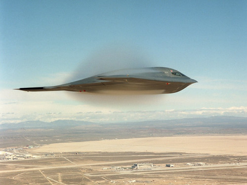
Northrop Grumman Integrated Systems was awarded a $171 million Air Force contract to begin a major step in developing a new satellite communications system for the B-2 Spirit stealth bomber, the company said Monday.
This 62-month phase will be the first of three increments in developing and installing the communications system. Once all three increments are completed, the upgrade will allow the B-2 to send and receive battlefield information up to 100 times faster than its current satellite communications system, the company said.
This contract "provides significant momentum for the work Northrop Grumman and its subcontractors are doing to increase the B-2’s fighting effectiveness in the face of technological advances by our enemies," said Dave Mazur, vice president of Long Range Strike for Northrop Grumman’s Integrated Systems sector, in a statement.
The project will enhance the B-2’s satellite communications system from ultra high frequencies, known as UHF, to extremely high frequency, or EHF.
Most of the work will occur in Palmdale, where Northrop houses its B-2 program, spokesman Brooks McKinney said.
Known as a flying wing because of its unorthodox shape, the Spirit has stealth properties that block enemy detection of the plane.
First introduced into the Air Force’s fleet in 1993, the B-2 has been one of the nation’s most high-profile warplanes because of its technological advancement and success in conflicts.
The first increment will involve replacing the B-2’s flight management computers with a single processing unit developed by subcontractor Lockheed Martin Systems Integration in Owego, N.Y.
The next increment of the upgrade will enable the plane to process signals at EHF frequencies.
The final increment will integrate the EHF capabilities with the aircraft’s controls and displays.
The new satellite communications system also will allow the B-2 to connect easily to the U.S. Department of Defense’s Global Information Grid, a worldwide network of information systems, processes and personnel involved in processing information on demand to warfighters, policy makers and military support people, Northrop said.
The B-2’s new communications system will be compatible with current and future secure military satellite communications networks.
The modernization program is the latest in a series of Northrop’s B-2 upgrades. Other past or ongoing improvements include:
A bomb-rack assembly that allows the aircraft to deliver 80 independently targeted, 500-pound "smart" munitions, five times more than previously.
Application of a surface coating that has reduced B-2 maintenance time and improved operational readiness.
Installation of a line-of-sight tactical communications system to improve pilots’ ability to share targeting and threat information.
Installation of an advanced antenna providing more advanced imaging capabilities in the future. El Segundo-based Raytheon Space and Airborne Systems is developing that antenna.
A decade ago, space tourism was just a dream, even for the richest of the rich. In 2001, Dennis Tito became the first space tourist, paying more than $20 million. Since then, a number of multi-millionaire and billionaires have made the journey on Russia’s Soyuz spacecraft. (The program is booked-up until 2009.) Now, space tourism might be possible for even six-figure savings accounts.
Looking to cash-in on the new desire for out-of-this-world travel, an explosion of commercial space tourism is underway. Most of the proposed programs propose suborbital flights, which still provide a traveler with a view of the earth’s curvature and a short period of weightlessness, without the danger and expense of full re-entry. Single tickets are expected to sell for $200 to $300 thousand dollars.
While a half-dozen companies are already developing plans (including RocketPlane and PlanetSpace), Virgin Galactic appears to be the most established. Galactic draws together the only company to actually put a privately developed craft into outerspace (California-based Scaled Composites) with the financial and marketing genius of British Billionaire, Richard Branson. The company will launch its “flights” as early as late-2009 from California’s Mojave Spaceport until New Mexico’s Spaceport America is complete (making Virgin Galactic essentially an American enterprise). Watch Virgin’s promotional simulation (very cool):
Now, Europe is expected to jump into the game with an announcement at this week’s Paris Air Show. From the London Times:
EUROPE is to enter manned space travel for the first time, almost half a century after the first cosmonaut orbited the Earth.
EADS Astrium, Europe’s biggest builder of satellites and rockets, is this week expected to announce plans to carry tourists into space. The firm is due to unveil plans at the Paris air show for a spacecraft that will carry tourists out of the atmosphere for a brief ride at 3,000mph before ferrying them back to Earth.
Europe stood on the sidelines during the space race between America and Russia in the cold war, largely because of the vast cost. The first human space flight carried Yuri Gagarin, the Soviet cosmonaut, once round the Earth in 1961, and in 1969 Neil Armstrong became the first person to set foot on the moon.
Europe’s programme, conducted through the European Space Agency, has confined itself to unmanned probes, such as the Giotto mission of 1986, which explored the tail of Halley’s comet. However, European astronauts, including the Britons Helen Sharman and Michael Foale, have flown on Russian and Nasa missions.
A spokesman for EADS Astrium said: “We are going to reveal a space tourism project next week for the Paris air show.” The scheme is thought to be the first step in a plan to take space tourists into orbit and even to dock at a “space hotel”.
It’s a reoccurring ritual. World leaders gather for a major summit such as the current G8 Summit in Rostock, Germany. Citizens and activist groups gather outside to unfurl banners, carry placards and hoist puppets in the air, all as a means of airing their grievances and points of view. And between these two groups, security personnel work to keep a respectable distance and, when possible, to keep the peace.
Serving those security and first responder forces is an integrated array of satcom technology:
ND SatCom, an SES ASTRA company, is supporting reliable communications during the G8 Summit in Heiligendamm (Germany) for first responders of the German Federal Agency for Technical Relief (THW). THW staff members will be providing technical assistance to the summit’s infrastructure and using the network for telephony and data exchange via satellite. A satellite-based communication network using SkyRAY Light, ND SatCom’s new antenna system, shall establish the link to THW headquarters in Bonn via a mobile station in Heiligendamm. The SkyRAY Light system is very fast to deploy and easy to use, which is of utmost importance in critical government applications. SkyRAY Light’s operational concept is plug & play. Antenna pointing is based on a one-button operation enabling non-technical first responders to be on air within minutes.
There’s no shortage of footage from the current G8 meeting in Rostock, incuding this clip from SkyNews featuring Annie Lennox:
But not all the protests are turning into clashes. Here’s a Flickr photo from Tuesday’s campaign stunt by Oxfam, the day before the G8 leaders arrived in Rostock for 2007’s G8 Summit, featuring the infamous ‘Big Heads’ dressed as Pinnochio:
Let’s hope this one turn out better than Sinosat-2 did. Here’s the news report, via IHT:
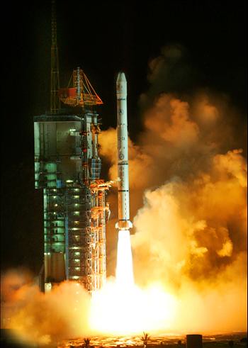
China launched a new communications satellite into orbit early Friday [1 June 2007] to provide broader radio and television signal coverage across the country, state media reported.
The Long March-3A rocket lifted off from the Xichang launching center in southwestern China eight minutes after midnight (1608 GMT) and separated from the SinoSat-3 satellite 24 minutes later, the Xinhua News Agency said.
The long-scheduled launch follows the failed deployment last October of another communications satellite, SinoSat-2, whose solar panels and communications antennae did not operate properly, Xinhua said.
China has spent decades building an indigenous space program and is trying to attract customers from abroad, after a series of failed launches in the 1990s dampened demand for Chinese launch services.
Both the rocket and the satellite used Friday were mainly developed and manufactured domestically, Xinhua said.
The satellite deployed Friday was not developed as a replacement for the inoperable SinoSat-2, Xinhua said, though Sino Satellite Communications Co., the satellite’s operators, may use SinoSat-3 to replace part of the service the other satellite was to have provided.
Xinhua quoted a company spokesman as saying that a substitute satellite would take at least three years to develop.
This Wednesday, at the ISCe 2007 Conference in San Diego, Robert E. Berry – former systems fellow and chairman of Ford Aerospace and SS/L – will be given a Lifetime Achievement Award.
More about Berry from the press release announcing the award:
"Berry led SS/L and its predecessor, Ford Aerospace, from 1977 to 2000 and, with his willingness to push innovative concepts, was responsible for some of the world’s most advanced communications and meteorological satellite projects for defense, civil, and commercial applications. He cultivated the international market for U.S.-based satellite manufacturing, and under his leadership, SS/L developed the technologies that have put the company at the forefront in providing high-power satellites for direct-to-home television, satellite radio, broadband Internet and international fixed satellite services."
During Berry’s tenure at Ford Aerospace, his team built many satellites for IntelSat, including the notable IntelSat 5 and IntelSat 7 series. After Ford Aerospace was sold to Loral in 1990, Berry led SS/L in developing the FS-1300, which was a very advanced and reliable satellite that in some cases exceeded its design life of 10 – 15 years.
"Berry was instrumental in providing three generations of satellite platforms to Intelsat, helping the intergovernmental consortium provide fixed satellite services to more than 149 countries, territories, and dependencies. He initiated and managed Ford Aerospace’s participation on the Milstar industry team and advocated multi-mission satellite systems, with SS/L providing military communication payloads for commercial satellites for France, Japan, Spain and Australia. Currently at SS/L, he consults with both government and commercial interests to explore new applications arising from combining satellite, wireless, and fibered transmission."
The ISCe 2007 conference takes place this week, June 5th – 7th, in San Diego. Besides honoring Robert Berry, the conference is hosting a number of other impressive speakers and sure-to-be engaging talks. Check out the speaker list here.
In a related note, Berry’s company Ford Aerospace is also where Linda Hudson, currently of BAE Systems, got her start. She was the first woman manager at Ford, overseeing the quality assurance division. After making a name for herself as an executive at Ford, she eventually became the first female vice president at General Dynamics and now, as the president of BAE’s land and armaments division, has made a significant impact in the defense industry with BAE’s recent $4.1 billion purchase of Armor Holdings. London newspaper The Times calls her "the most powerful woman in the American defence industry" (link).
Recently, Hudson travelled to London to host a BAE leadership conference. She must have made quite an impression, as one British observer noted that "she talked a lot of sense – without the jingoism and rubbish you normally hear from American defence experts" (link).
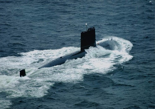
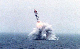
The launch of South Africa’s first government satellite from a Russian submarine next month has been postponed indefinitely, an official said on Tuesday.
"It has been postponed because official documentation still needs to be arranged to issue a decree for the launch," said Nhlanhla Nyide, spokesman for the Department of Science and Technology.
"They are currently working on the process … We will hear from them when they have set a new date for launch," Nyide said.
He told said no additional costs will be incurred and South Africa’s nascent space programme would not be affected because of the cancellation of the launch, which was to have taken place in the Barents Sea near Norway.
The R26-million satellite, intended to orbit some 500 km (310 miles) above earth and have a life-span of three years and longer, would carry high-resolution imaging cameras.
The images from the South African-built satellite would be used across a wide array of applications, from agriculture to land use and infrastructure mapping.
South Africa has pledged millions of rands to build its astronomy and space sector, with the construction of the South African Large Telescope creating a hub for astronomy research in southern Africa.
In July 2006 cabinet approved the establishment of a South African Space Agency as an institutional vehicle to look at space science and technology.
This would have been a cool launch. Back in December, 2006, the satellite was handed off to Russia:
South Africa’s low-earth-orbiting microsatellite, SumbandilaSat, left for Russia on Thursday, ahead of its launch into space off a submarine in early 2007.
The 81-kg SumbandilaSat will generate satellite imagery through its remote sensing camera at 6,25 m ground sampling distance.
Upon arrival in Russia, SumbandilaSat will be taken to the Russian naval base at Murmansk, where the Russian navy will integrate it with a launch rocket. The satellite will then be transported to a submarine at Severemorsk, just off the Russian coast, where it will be launched into space.
The launch window period is between April and May and is strongly dependent on weather conditions at the time. Once in orbit, SumbandilaSat will pass over South Africa mid-morning and mid-evening, at an average orbit altitude of 500 km.
In addition to its earth observation and communications payloads, SumbandilaSat carries five experimental payloads, which will present the scientific community with exciting results in low frequency radio waves, radiation, software defined radio, forced vibrating string and radio amateur transponders.
Speaking at the hand-over ceremony, in Stellenbosch, Science and Technology Minister Mosibudi Mangena said that the development of SumbandilaSat offered South Africa a number of competitive advantages and would support decision-making in natural resource management and sustainable development. He added that the images yielded by the satellite would be used in various applications, which had direct benefits to societies, such as flood and fire disaster management; enhancing food security through crop yield estimation; ensuring better human and animal health through enabling the prediction of the outbreaks of diseases; better monitoring of land cover and use; as well improved capabilities for water resource management.
The actual construction of the SumbandilaSat had been completed at the end of September and had been followed by a battery of trials, including functional testing, space environmental testing, vibration testing and burn-in testing, designed to establish the satellite’s readiness prior to a flight acceptance review.
“The environmental-testing phase determined SumbandilaSat’s ability to withstand extreme variance in temperatures, while the vibration tests verified its ability to endure the shocks it will undergo as it is launched into space. The burn-in testing phase comprised the actual and continual running of the satellite and its systems in order to confirm that all components are fully functional,” the Department of Science and Technology (DST) said.
Sunspace project manager for SumbandilaSat Harry van der Heyden said that the review presentation included an introduction to the hardware produced, as well as the ground support equipment developed for the satellite. “We also conducted demonstrations to illustrate how the satellite communicates with the ground support equipment.”
The birth of SumbandilaSat was initiated by the DST and was given life by numerous stakeholders, including the University of Stellenbosch, Sunspace, the South African Space Council, the Departments of Foreign Affairs, Trade & Industry, and Communications, as well as the Centre for Scientific and Industrial Research.
The launch of SumbandilaSat is envisaged to strengthen South Africa’s technological capability and innovation in space science and technology, as well as reinforce the country’s role in national, regional and international space initiatives.


 It’s a