Posts Tagged ‘moon’

Big Bang Monday: The Shrinking Moon

Monday, October 28th, 2013

Smithsonian scientist Tom Watters thinks the moon is shrinking

By looking at images and data taken by the Lunar Reconnaissance Orbiter, a team of scientists, including Watters, a planetary scientist in the Center for Earth and Planetary Studies at the National Air and Space Museum, were able to examine geological features on the moon called lobate scarps—thrust faults that occur primarily in the lunar highlands. These scarps are the result of the interior of the moon slowly cooling, and as it does so, it shrinks causing its surface area to crack and buckle.

“One of the remarkable aspects of the lunar scarps is their apparent young age,” said Watters. “Relatively young, globally distributed thrust faults show recent contraction of the whole moon, likely due to cooling of the lunar interior. The amount of contraction is estimated to be about 100 meters in the recent past.

The moon’s lobate scarps were first recognized in photographs taken near the moon’s equator by the panoramic cameras flown on the Apollo 15, 16 and 17 missions. Fourteen previously unknown lobate scarps have now been revealed in very high resolution images taken by the Lunar Reconnaissance Orbiter Camera. The newly detected scarps indicate that the thrust faults are globally distributed and not clustered near the moon’s equator.

“The ultrahigh resolution images from the Narrow Angle Cameras are changing our view of the moon,” said Mark Robinson of the School of Earth and Space Exploration at Arizona State University, coauthor and principal investigator of the Lunar Reconnaissance Orbiter Camera. “We’ve not only detected many previously unknown lunar scarps, we’re seeing much greater detail on the scarps identified in the Apollo photographs.”

Because the size change is relatively small, however, Watters said that there would be no effect on lunar cycles, tides, etc. It would take millions of years for there to be a perceivable difference in the size of the moon to the naked eye. But this discovery does help change the commonly held belief that the moon is just a dead rock, showing that it is still active and dynamic.

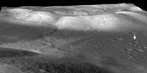
The mare basalts that fill the Taurus-Littrow valley were thrust up by contractional forces to form the Lee-Lincoln fault scarp, just west of the Apollo 17 landing site (arrow). It is the only extraterrestrial fault scarp to be explored by humans (astronauts Eugene Cernan and Harrison Schmitt). The digital terrain model derived from Lunar Reconnaissance Orbiter Camera (LROC) stereo images shows the fault extending upslope into North Massif were highlands material are also thrust up. The fault cuts upslope and abruptly changes orientation and cuts along slope, forming a narrow bench. LROC images show boulders shed from North Massif that have rolled downhill and collected on the bench. Credit: NASA/GSFC/Arizona State University

Apollo 17 images are some of those Moon prints featured by BigBangPrints.com, and you can get some LROC love here.


Dark Side of the Moon

Tuesday, September 17th, 2013

Pink Floyd has sold more than 40 million copies of the album “Dark Side of the Moon” — the title refers to lunacy, not the actual Moon.

Today’s APOD features something we’ve never seen before: the rotating moon…

No one, presently, sees the Moon rotate like this. That’s because the Earth’s moon is tidally locked to the Earth, showing us only one side. Given modern digital technology, however, combined with many detailed images returned by the Lunar Reconnaissance Orbiter (LRO), a high resolution virtual Moon rotation movie has now been composed. The above time-lapse video starts with the standard Earth view of the Moon. Quickly, though, Mare Orientale, a large crater with a dark center that is difficult to see from the Earth, rotates into view just below the equator. From an entire lunar month condensed into 24 seconds, the video clearly shows that the Earth side of the Moon contains an abundance of dark lunar maria, while the lunar far side is dominated by bright lunar highlands. Two new missions are scheduled to begin exploring the Moon within the year, the first of which is NASA’s Lunar Atmosphere and Dust Environment Explorer (LADEE). LADEE, which launched just over a week ago, is scheduled to begin orbiting the Moon in October and will explore the thin and unusual atmosphere of the Moon. In a few months, the Chinese Chang’e 3 is scheduled to launch, a mission that includes a soft lander that will dispatch a robotic rover.

Maybe Syd Barrett can see it.


The Flags Are Still There

Tuesday, July 31st, 2012

Sorry, Euro-hipster communists: the moon landings weren’t faked by the U.S. government. The folks behind the Lunar Reconnaissance Orbiter Camera (LROC) recently released images showing the Apollo landings’ flags were still standing, except for Apollo 11. Buzz Aldrin said they knocked it down as they left the Moon’s surface.

From the LROC images it is now certain that the American flags are still standing and casting shadows at all of the sites, except Apollo 11. Astronaut Buzz Aldrin reported that the flag was blown over by the exhaust from the ascent engine during liftoff of Apollo 11, and it looks like he was correct! The most convincing way to see that the flags are still there, is to view a time series of LROC images taken at different times of day, and watch the shadow circle the flag (see movie below; the flag is just above the LM descent stage).

Some of the images from the Apollo landings are stunning — and for real!

Dude, Check Out The Moon!

Friday, November 18th, 2011

Yeah, that’s cool. It’s a new 100m scale map of the moon, says NASA

“Our new topographic view of the moon provides the dataset that lunar scientists have waited for since the Apollo era,” says Mark Robinson, Principal Investigator of the Lunar Reconnaissance Orbiter Camera (LROC) from Arizona State University in Tempe. “We can now determine slopes of all major geologic terrains on the moon at 100 meter scale. Determine how the crust has deformed, better understand impact crater mechanics, investigate the nature of volcanic features, and better plan future robotic and human missions to the moon.”

Called the Global Lunar DTM 100 m topographic model (GLD100), this map was created based on data acquired by LRO’s WAC, which is part of the LROC imaging system. The LROC imaging system consists of two Narrow Angle Cameras (NACs) to provide high-resolution images, and the WAC to provide 100-meter resolution images in seven color bands over a 57-kilometer (35-mile) swath.

The WAC is a relatively small instrument, easily fitting into the palm of one’s hand; however, despite its diminutive size it maps nearly the entire moon every month. Each month the moon’s lighting has changed so the WAC is continuously building up a record of how different rocks reflect light under different conditions, and adding to the LROC library of stereo observations.

The LROC (WAC) has a pixel scale of about 75 meters (246 feet), and at the average altitude of 50 km (31 miles) a WAC image swath is 70 km (43 miles) wide across the ground-track. Since the equatorial distance between orbits is about 30 km (18 miles) there is complete overlap all the way around the moon in one month. The orbit-to-orbit WAC overlap provides a strong stereo effect. Using digital photogrammetric techniques, a terrain model can be computed from the stereo overlap.

The near-global topographic map was constructed from 69,000 WAC stereo models and covers the latitude range 79°S to 79°N, 98.2% of the entire lunar surface. Due to persistent shadows near the poles it is not possible to create a complete stereo based map at the highest latitudes. However, another instrument onboard LRO called LOLA excels at mapping topography at the poles. Since LOLA ranges to the surface with its own lasers, and the LRO orbits converge at the poles, a very high resolution topographic model is possible, and can be used to fill in the WAC “hole at the pole.” The WAC topography was produced by LROC team members at the German Aerospace Center.