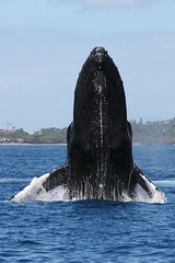
Using Satellites to Study Whales
 For decades, Japan’s scientific whaling program has killed thousands of whales as part of what it calls necessary research.
Needless to say, Japan’s whaling program has been a point of contention with the environmental group Greenpeace for just as long.
Now, however, Greenpeace is leading the fight against whaling a different way — by example:
Greenpeace announced a satellite-based tracking system to monitor endangered South Pacific humpback whales, saying it is not necessary to kill the animals as Japan does to study them…
Humpback whales from Rarotonga and New Caledonia have been satellite tagged and are "now being tracked in order to produce vital data on their movements, habitat use and population structure," said Greenpeace New Zealand’s oceans campaigner, Mike Hagler.
"The tagging program is producing real scientific results" on whale migrations from breeding grounds in the South Pacific to feeding grounds of the Southern Ocean "without firing a single harpoon," he said.
Tracking whale migration is critical to developing plans and policies to preserve the species; satellite tracking is a natural solution to the problem of tracking big mammals in an even bigger ocean. Whalenet has a good description of how satellite tracking works for whales:
WhaleNet uses satellite transmitters that send signals to satellites maintained by the ARGOS System in Largo, Maryland and Talouse, France. A number of the U.S. National Oceanographic and Atmospheric Administration’s (NOAA) weather satellites, circling the earth, have ARGOS instruments attached. These instruments collect, process and disseminate environmental data relayed from fixed and mobile transmitters worldwide. What makes ARGOS’s system unique is the ability to geographically locate the source of the data anywhere on the Earth.
Data is collected by the tag while the marine animal is underwater and then transmitted when the animal surfaces. The tag has an antennae which is used to send a signal each time the animal surfaces. Information relayed includes time, date, latitude, longitude, dive depths, dive durations, amount of time at the surface in the last six hours and quality of the transmission. The ARGOS instruments detect the tag’s signal when the satellite passes overhead.
The location fix of the animal in relationship to the track of the satellites, with ARGOS instruments, affects how many satellites passes are made over the animal’s tag in a 24 hour period. Each pass may last between 2 and 12 minutes, depending on the location of the satellite in relation to the animal. The animal must be at the surface at the time of the pass for a successful transmission to take place. Therefore, each day there are a limited number of short opportunities, or maybe no opportunities, for a signal to be transmitted from an animal’s tag to a satellite.
How are they attached?
With whales the tag is attached by partially implanting a barb into the blubber layer at a slight angle, to a depth of approximately 10 cm. Ideally it is placed high on the back of the whale, directly behind the blow hole. These tags are deployed using a compound crossbow. A study by the Minerals Management Society determined that this does not cause serious stress or pose a health risk to the whale. The tagging team goes out in a 4 meter rigid-hull inflatable equipped with an outboard motor in order to get close enough to the whale to implant the tag.
There’s no relation, we hear, between the satellite tracking of whales and the chip implants for your pet.