Archive for the ‘Satellites’ Category

Coolest Moon Mission

Monday, June 15th, 2009

I’d have to agree with Mike Swift of the San Jose Mercury News that Wednesday’s scheduled launch from the Cape on Wednesday, 17 June 2009, will be the beginning of the coolest moon mission ever:

LCROSS may be one of NASA’s most participatory missions. If the spacecraft launches on schedule at 12:51 p.m. Wednesday, it would hit the moon in the early morning hours of Oct. 8. The cloud from the 350 metric tons of debris kicked up by the Centaur booster should spread six miles above the surface of the moon, hitting the sunlight and making it visible to amateur astronomers across North America. The space agency is enlisting telescopes around the country to help monitor the impact.

The 1,664-pound spacecraft will have the best view. LCROSS will separate from the Centaur booster less than 10 hours before impact and will be less than 400 miles above the moon when the spent rocket booster collides at a speed five times faster than a bullet from a .44 Magnum. NASA plans to stream a live view from LCROSS as the Centaur, followed by the spacecraft, plows into the moon.

Over the final four minutes of its existence, as it follows the same terminal trajectory as the Centaur, LCROSS will train its instruments and cameras on the debris cloud, searching it for the chemical signature of water.

Previous spacecraft and ground-based instruments have detected signs of hydrogen near the moon’s poles, and scientists are split over whether that is from ice that could have arrived through the impact of comets or by other means. That ice could have lingered for more than a billion years at the bottom of craters near the lunar poles that have never seen sunlight, where temperatures are more than 300 degrees below zero Fahrenheit.

And despite all the serious scientific talk about hydrogen signatures and lunar regolith, flying a rocket booster into the moon at 5,600 mph to trigger a massive explosion is just flat-out cool.

"We’re certainly going to be making a big splash," Ennico said. "We’re going to see something, but I don’t know what to expect. I know on the night of the impact, I’ll be running on adrenaline."

Found this very good simulation on YouTube:


And here’s the video from Northrop-Grumman…


TerreStar Launch Slips

Wednesday, June 10th, 2009


Last month, Eutelsat reported an on-orbit anomaly to its W2A spacecraft’s S-band payload. Although disclosure of this type is material to a  firm’s financial performance, most spacecraft bus and/or payload anomalies are shared with other operators.

Unlike the business side, spacecraft engineering departments know what their counterparts are up to — especially when it comes to anomalies. On-orbit anomalies? Everybody knows about them almost instantly, although it may not become public information for weeks or months.

For those designing/building payloads on the ground, this is absolutely essential information. Make changes now, or "pfft," you’re done. That’s why the TerreStar-1’s launch is slipping a few weeks:

…the launch of TerreStar-1 has been rescheduled for a July 7-12, 2009 window to permit additional time to ensure that an on-orbit anomaly that occurred recently on another operator’s satellite has no bearing on the flight worthiness of TerreStar-1.

"While our vendors have assured us that TerreStar-1 is ready to launch, we believe this short delay may provide a window for additional data to verify that TerreStar-1, including its 18 meter reflector, is unaffected by the anomaly reported by another operator’s S Band satellite," Dennis Matheson, CTO of TerreStar said.

Arianespace, TerreStar-1’s launch services provider, has agreed to this updated launch schedule.

"Throughout the construction of TerreStar-1 we have emphasized quality and certainty over speed. Today’s revised launch schedule is another example of our commitment to eliminate unnecessary risks when we can," said Jeffrey Epstein, President of TerreStar. 

The Eutelsat W2A anomaly prompted a terse statement from Solaris Mobile, the payload’s beneficiary:

Solaris Mobile and its shareholders Eutelsat Communications and SES Astra announce that the current evaluation of the in-orbit tests of the S-band payload on the W2A satellite launched on April 3 indicate an anomaly which requires further tests.

Additional analysis is consequently planned with the satellite’s prime contractor, Thales Alenia Space, in order to identify the cause of the anomaly and to fully assess the extent of the Sband payload’s capability to provide mobile satellite services to the European marketplace.

Solaris Mobile remains confident of its ability to meet the commitments made according to the European Selection and Authorisation Process, under which it has applied for S-band spectrum to provide these services. The company is evaluating a range of options to compensate for this situation and expects to make further announcements in due course.

Crash-Landing Kaguya

Tuesday, June 9th, 2009


Japan’s Kaguya spacecraft is expected to crash into the moon this week. Yeah, this is serious business, according to Inside Japan:

The Japanese Kaguya lunar orbiter is to conclude its research mission in dramatic fashion by crash-landing on the moon later this week.

Observers will be watching the moon’s near side for the final impact made by the probe, which has been in orbit around Earth’s satellite since late 2007, at 18:30 GMT on June 10th.

The mission of the Kaguya probe, formerly codenamed Selene, was to aid study of the evolution of the moon by collecting data on its composition and gravitational field, as well as recording high-definition video of its surface.

Collision with the moon is the typical destiny of such orbiters, with the European Space Agency’s SMART-1 and the Chinese Chang’e 1 among the probes to impact upon the lunar surface in the last two years.

Shin-ichi Sobue, a spokesperson for the Kaguya mission, described the forthcoming collision as "a final show for the Japanese people".

This "landing" will undoubtedly add an exclamation point to the fine video footage gathered by JAXA and partner NHK. This eart-rise is a fine example:


Ask The Satellites

Thursday, June 4th, 2009

Here’s the latest infrared image of the Atlantic Ocean region that includes the path of AF447:


France is asking the U.S. DoD for help in finding clues:

France has also asked Washington to scan data from its spy satellites and electronic intelligence facilities for clues.

US Air Force Defense Support Program (DSP) missile warning satellite data, collected early 1 June over the central Atlantic, will be examined to see if a breakup or impact of a crashing aircraft was captured.

Experts say two or three Northrop Grumman DSPs constantly scan that region of the Earth with powerful infrared telescopes. The satellites, based in geosynchronous orbit at nearly 23,000 miles in altitude, are designed to detect the heat from the launch of land or sea based ballistic missiles.

Each satellite carries a 6,000 element mercury-cadmium-telluride detector which is capable of discriminating not only missile launches but other thermal phenomenon such as lightning, meteorites and aircraft that are flying on afterburner or on fire.

Other systems being tapped for data will include two new Space Based Infrared System (SBIRS) sensors onboard two National Reconnaissance Office spacecraft in highly elliptical orbits. Unlike DSPs, the new SBIRS satellites are yet to provide continual coverage of all areas of Earth. It remains to be seen if a SBIRS system was pointing in the area of the crash.

SIGINT (signal intelligence) "eavesdropping" spacecraft data will also be examined for unusual static or other transmissions which may have been picked up coming from the stricken aircraft.

Penguin Surveillence

Wednesday, June 3rd, 2009


Holy Satellite, Batman! It’s the Penguin!

No, not really, citizens. I wish this story was as entertaining as the Batman TV series from the 1960s.  The story here handed the British press a fantastic story. Note the great lead in the piece from The Times:

 It may be the king of the species but the personal hygiene of emperor penguins is far from regal. Vast expanses of penguin droppings that are visible from space are helping scientists pinpoint the whereabouts of penguin colonies in Antarctica.

Using satellite images, British scientists were able to locate penguin communities by the reddish brown patches, known as guano, left by the birds on the sea ice. They say the results of the study will help them to monitor the emperor penguin population in the face of climate change.

Emperors, which have white bellies, black backs and distinctive golden ear patches, are the largest members of the penguin family. They can grow to 122cm (4ft) tall and weigh around 30kg (5st) as adults.

“The ice gets pretty dirty and it’s the guano stains that we can see,” said Peter Fretwell of the British Antarctic Survey (BAS), who led the study.


The video clip from the Associated Press was just as tasteful, and informative…


Other editors had a field day with this one.

Polar penguin’s poo pinpointed in space pics (Tech Herald)

Scientists hit pay dirt with penguin droppings (Sydney Morning Herald)

Satellite snoops on penguin poop to track colonies (AFP)

Penguin poo patches seen from space (The Press Association)


GAO on GPS to USAF: WTF?

Wednesday, May 20th, 2009


The GAO’s report on the state of the GPS system is causing some alarm among those in the satellite navigation and geolocation community:

 It is uncertain whether the Air Force will be able to acquire new satellites in time to maintain current GPS service without interruption. If not, some military operations and some civilian users could be adversely affected. (1) In recent years, the Air Force has struggled to successfully build GPS satellites within cost and schedule goals; it encountered significant technical problems that still threaten its delivery schedule; and it struggled with a different contractor. As a result, the current IIF satellite program has overrun its original cost estimate by about $870 million and the launch of its first satellite has been delayed to November 2009–almost 3 years late. (2) Further, while the Air Force is structuring the new GPS IIIA program to prevent mistakes made on the IIF program, the Air Force is aiming to deploy the next generation of GPS satellites 3 years faster than the IIF satellites. GAO’s analysis found that this schedule is optimistic, given the program’s late start, past trends in space acquisitions, and challenges facing the new contractor. Of particular concern is leadership for GPS acquisition, as GAO and other studies have found the lack of a single point of authority for space programs and frequent turnover in program managers have hampered requirements setting, funding stability, and resource allocation. (3) If the Air Force does not meet its schedule goals for development of GPS IIIA satellites, there will be an increased likelihood that in 2010, as old satellites begin to fail, the overall GPS constellation will fall below the number of satellites required to provide the level of GPS service that the U.S. government commits to. Such a gap in capability could have wide-ranging impacts on all GPS users, though there are measures the Air Force and others can take to plan for and minimize these impacts. In addition to risks facing the acquisition of new GPS satellites, the Air Force has not been fully successful in synchronizing the acquisition and development of the next generation of GPS satellites with the ground control and user equipment, thereby delaying the ability of military users to fully utilize new GPS satellite capabilities. Diffuse leadership has been a contributing factor, given that there is no single authority responsible for synchronizing all procurements and fielding related to GPS, and funding has been diverted from ground programs to pay for problems in the space segment. DOD and others involved in ensuring GPS can serve communities beyond the military have taken prudent steps to manage requirements and coordinate among the many organizations involved with GPS. However, GAO identified challenges to ensuring civilian requirements and ensuring GPS compatibility with other new, potentially competing global space-based positioning, navigation, and timing systems.

Cost overruns and a diminishing number of spacecraft engineers are likely the root causes.

Satellite News Bits

Monday, May 11th, 2009

All your satcom news is mine, via Bill McDonald:

TacSat 3 launch scrubbed May 7 due to bad weather in Wallops Island area.
[Satnews – 05/08/2009]

Russia successfully places Express AM44 satellite, named after A.S. Popov, into operation at 11 West within the Russian Satellite Communications Company satellite constellation.
[Satnews – 05/07/2009]

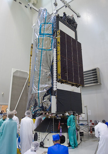
Pathfinder Space Tracking and Surveillance System (STSS) Advance Technology Risk Reduction (ATRR) satellite successfully launched from Vandenberg AFB by the Missile3 Defense Agency, supported by NASA and commercial firm United Launch Alliance.
[Satnews – 05/07/2009]

Planned acquisition of DataPath by Rockwell Collins receives approval of stockholders.
[Satnews – 05/07/2009]

El Corte Ingles will distribute Eutelsat’s Tooway satellite broadband service to retail customers in Spain.
[Satellite Today – 05/07/2009]

Space Systems/Loral  is selected to provide new communication s satellite, AsiaSat 5C, to Asia Satellite Telecommunications Company Limited.
[Satnews – 05/07/2009]

TacSat-3 is  scheduled for May 7 launch from Wallops Island; features 3 revolutionary trials including Raytheon’s advance imaging spectrometer, Air Force avionics experiment, and Office of Naval Research’s satellite communications package.
[NASA – 05/06/2009]

DirecTV merger with John Malone’s Liberty Entertainment results in simplification of DirecTV’s ownership, setting the stage for future deals.
[Satnews – 05/06/2009]

KVH debuts TracPhone FB150, 10.5" in diameter and 12" high, to offer small, cost effective broadband internet package for maritime applications, suited for boats as small as 40 ft.
[TMC Net – 05/06/2009]

C2SAT, actively working to establish a new presence in China covering local production facilities and product sales, is rewarded by largest single order to date, seven C2SAT 2.4m C-band antennas within six months.
[Satnews – 05/06/2009]

HD DTH satellite service to be offered in Phillipines by the Phillippine Long Distance Telephone Company and MediaQuest.
[Satellite Today – 05/06/2009]

Echo Satellite, offering satellite communications "hotspots" enabling wireless coverage for multiple users in any non-line-of-sight environment, changes name to SatMax in response to request from EchoStar Corp.
[Houston Business Journal – 05/05/2009]

Spacenet Inc. provides transportable satellite communications solutions to Erie Insurance for mobile claim centers.
[Globe Newswire – 05/05/2009]

Australian government’s national high-speed national broadband strategy, "Ruddnet", focusing on 100mbps fiber connectivity to 90% of the population, and 12 mbps satellite connectivity to the rest, divides the nation.
[The Australian – 05/05/2009]

NASA officials lobby for extension of shuttle program to close gap between shuttle program and debuting of the Ares/Orion manned flight capability.
[R&D magazine – 05/04/2009]

U.S. military to launch experimental tactical satellite to demonstrate inexpensive user-friendly space technologies.
[Space.com – 05/04/2009]

AT&T CruiseCast car satellite system for in-car video, currently offering 22 channels, is soft-launched at select retail outlets.
[twice-com – 05/04/2009]

Giga-Com delivers satellite broadcast solutions to Kuwaiti government.
[Satellite Today – 05/04/2009]

French Airline installs Panasonic satellite in-flight entertainment system.
[Satellite Today – 05/04/2009]

Australian satellite company Codan acquires Locus Microwave.
[Satellite Today – 05/04/2009]

KVH announces promotion to make it easier for "big dish" maritime users to "move down" to the KVH "mini-VSAT" broadband service using the TracPhone V7(R) hardware.
[PR Newswire – 05/04/2009]

China Electronics Technology Group chief engineer states that China will be able to provide free global navigation and positioning services by 2020 with its own constellation of satellites named "Compass."
[Satnews – 05/04/2009]

Abu Dhabi or Dubai targeted to be host of new spaceport for space tourism in talks between Virgin Galactic and parties in the UAE.
[The National – May 3, 2009]

SatMagazine interviews Rob Bednarek, President and CEO of SES AMERICOM-NEW SKIES.
[SatMagazine, May 2009]

Finding the Next Generation Aerospace workers for the U.S. Satellite Industry (a crisis in looming in the workforce).
[SatMagazine feature – May 2009}

SatMagazine interviews Charlie Maloney, GOES N-P Program Manager for Boeing Space and Intelligence Systems, responsible for final systems test and launch preparations for next generation GOES satellites.
[SatMagazine – May 2009]

SatMagazine interviews Dr. Jesus Villasenor of M.I.T. and Mr. Luke Volpe of Dynamics Research Corp., about NASA’s HETE mission.
[SatMagazine – May 2009]

NSR Report – Supervisory, Control and Data Acquisition (SCADA) as well as Machine-to-Machine (M2M) services largely recession-proof; satellite platforms providing reliable ubiquitous communications to widely separated areas becoming increasingly important in these vertical markets.
[NSR Report – May 2009]

C2SAT – technology for the future – 4 axis antenna designed to increase reliability, precision, and accuracy of maritime terminal tracking of satellites for all vessels.
[SatMagazine feature – May 2009]


Extreme Solar Activity

Tuesday, May 5th, 2009


 We all depend on the Sun for life. Whether we know it or not, those of us who watch TV depend on communications satellites for efficient distribution. Broadcast television networks, cable TV, and, of course, direct broadcast satellite — they all depend on satcom systems to get their programming to us, 24x7x365.

Now, more than ever, people are personally dependent on GPS satellites to find their way. Hosted a party over the weekend, and it was the first time nobody asked for direction. "We got GPS," was the response.

Us rocket scientists — and various "sat nuts" who follow these activities — have know the Earth’s magnetic fields are greatly affected by the Sun’s activities, such as sunspots.

The European Space Agency published a report measuring such extreme solar events last week:

“With these detailed observations, we’ll be able to plug in data and better estimate what happens to the inner magnetosphere and near-Earth space during such explosions on the Sun”, said Iannis Dandouras, lead author of the results published recently, and Principal Investigator of the Cluster Ion Spectrometer.

“Looking at such a large-scale physical phenomena with a single satellite is akin to predicting the impact of a tsunami with a single buoy,” added Matt Taylor, ESA’s Project Scientist for Cluster and Double Star. “With Cluster and Double Star we have monitored both sides of Earth simultaneously, and obtained valuable in-situ data.”

Get deeper here. And be sure to check out the animations and images.


Close Encounters With Mercury

Friday, May 1st, 2009

Well if I had money
I tell you what I’d do
I’d go downtown and buy me a Mercury or two
Crazy bout a Mercury
I’m gonna buy me a Mercury
And cruise it up and down the road


Ford’s Mercury brand did make some cool cars, back in the day. I remember their product placements in the Hawaii Five-O TV series. Which, to this day, has law enforcement types exclaiming "book em , Danno!" I can’t remember the last time Mercury had a popular model (always liked the ’67 Cougar).

You know who’s got money for a Mercury? NASA! The MESSENGER spacecraft (MErcury Surface, Space ENvironment, GEochemistry, and Ranging) just did a second fly-by of  the planet Mercury found there’s more to it:

Analyses of data from the MErcury Surface, Space ENvironment, GEochemistry, and Ranging (MESSENGER) spacecraft’s second flyby of Mercury in October 2008 show that the planet’s atmosphere, magnetosphere, and geological past are all characterized by much greater levels of activity than scientists first suspected.

On October 6, 2008, the probe flew by Mercury for the second time, capturing more than 1,200 high-resolution and color images of the planet unveiling another 30 percent of Mercury’s surface that had never before been seen by spacecraft and gathering essential data for planning the remainder of the mission.

“MESSENGER’s second Mercury flyby provided a number of new findings,” says MESSENGER Principal Investigator Sean Solomon at the Carnegie Institution of Washington. “One of the biggest surprises was how strongly the planet’s magnetospheric dynamics changed from what we saw during the first Mercury flyby in January 2008. Another was the discovery of a large and unusually well preserved impact basin that was the focus for concentrated volcanic and deformational activity. The first detection of magnesium in Mercury’s exosphere and neutral tail provides confirmation that magnesium is an important constituent of Mercury’s surface materials. And our nearly global imaging coverage of the surface after this flyby has given us fresh insight into how the planet’s crust was formed.”


 Nice animation…


Far Out

Tuesday, April 28th, 2009


Tommy Chong of Cheech & Chong said it best: "Far out, man!"

I wonder if somebody at NASA’s Goddard Space Flight Center said something similar about this blast from the past, maybe 13 billion light years away:

NASA’s Swift satellite and an international team of astronomers have found a gamma-ray burst from a star that died when the universe was only 630 million years old, or less than five percent of its present age. The event, dubbed GRB 090423, is the most distant cosmic explosion ever seen.

"Swift was designed to catch these very distant bursts," said Swift lead scientist Neil Gehrels at NASA’s Goddard Space Flight Center in Greenbelt, Md. "The incredible distance to this burst exceeded our greatest expectations — it was a true blast from the past."

At 3:55 a.m. EDT on April 23, Swift detected a ten-second-long gamma-ray burst of modest brightness. It quickly pivoted to bring its ultraviolet/optical and X-ray telescopes to observe the burst location. Swift saw a fading X-ray afterglow but none in visible light.

"The burst most likely arose from the explosion of a massive star," said Derek Fox at Pennsylvania State University. "We’re seeing the demise of a star — and probably the birth of a black hole — in one of the universe’s earliest stellar generations."

Gamma-ray bursts are the universe’s most luminous explosions. Most occur when massive stars run out of nuclear fuel. As their cores collapse into a black hole or neutron star, gas jets — driven by processes not fully understood — punch through the star and blast into space. There, they strike gas previously shed by the star and heat it, which generates short-lived afterglows in many wavelengths.

"The lack of visible light alone suggested this could be a very distant object," explained team member Edo Berger of Harvard University.

Beyond a certain distance, the expansion of the universe shifts all optical emission into longer infrared wavelengths. While a star’s ultraviolet light could be similarly shifted into the visible region, ultraviolet-absorbing hydrogen gas grows thicker at earlier times. "If you look far enough away, you can’t see visible light from any object," he noted.

Within three hours of the burst, Nial Tanvir at the University of Leicester, U.K., and his colleagues reported detection of an infrared source at the Swift position using the United Kingdom Infrared Telescope on Mauna Kea, Hawaii. "Burst afterglows provide us with the most information about the exploded star and its environs," Tanvir said. "But because afterglows fade out so fast, we must target them quickly."

At the same time, Fox led an effort to obtain infrared images of the afterglow using the Gemini North Telescope on Mauna Kea. The source appeared in longer-wavelength images but was absent in an image taken at the shortest wavelength of 1 micron. This "drop out" corresponded to a distance of about 13 billion light-years.

Here’s a video of what a gamma ray burst would look like up-close (Credit: NASA/Swift/Cruz deWild):