Double-Header Launch for Orbital


They’ll be up early in Sydney, Australia, on Saturday morning, watching a rocket launch their new satellite — and the same goes for Intelsat in Pembroke, Bermuda, too.

For the past few weeks, Orbital Sciences has been very busy at Europe’s Spaceport in Kourou preparing for their "double-header:" they built both "passengers" set to be carried by Arianespace. Looks like a "go" for an Ariane 5 (GS configuration) launching Optus D2 and Intelsat 11 on Friday, 5 October 2007:

Arianespace’s fourth mission of 2007 is set for Friday, October 5, with the green light given today after the launch readiness review at Europe’s Spaceport.

This review, which is held before every Ariane flight, verifies the readiness of the Ariane 5 vehicle, its two payloads, the launch infrastructure at the Spaceport in French Guiana, and the downrange network of tracking stations.

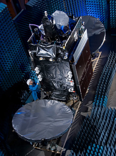
The upcoming mission will orbit two medium-sized satellites built by the same U.S. manufacturer, Virginia-based Orbital Sciences Corporation, for Intelsat and Optus.

The Intelsat 11 spacecraft is riding in Ariane 5’s upper payload position, and is to be released first in the mission sequence. To be operated by Washington, D.C.-headquartered Intelsat, the satellite will host Latin America’s premiere video programmers and the region’s largest DTH (direct-to-home) platform. Intelsat 11 is based on the Orbital Sciences STAR 2 spacecraft bus, and carries a hybrid payload composed of 16 C-band and 18 Ku-band transponders. The satellite weighs approximately 2,500 kg. at launch.

Optus D2 also uses an Orbital Sciences STAR 2 bus, and is to be operated by Australian-based Optus to enable the development of new business opportunities for the direct-to-home market, new data services and services bundling. Positioned at an orbital slot of 152 deg. East, the 2,350-kg.

45-minute launch window opening, by city:

  • GMT: 21:28 on 5 OCT 2007
  • Luxembourg: 23:28 on 5 OCT 2007
  • New York: 17:28 on 5 OCT 2007
  • Kourou, French Guiana (local time): 18:28 on 5 OCT 2007
  • Sydney: 07:28 on 6 OCT 2007

Watch the live Webcast here.

Here’s Intelsat 11 being tested…

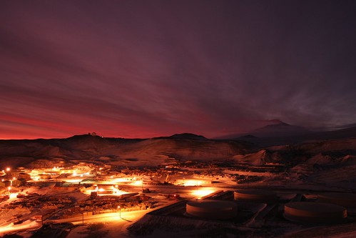
Antarctic Connection by Optus


The U.S. Antarctic Program, administered by the National Science Foundation, will be using Australia’s Optus D1 satellite to keep their facilities around McMurdo Sound connected, using the earth station on Black Island, by becoming part of the National Polar-orbiting Operational Environmental Satellite System (NPOESS) network

NPOESS will use polar-orbiting satellites to observe Earth from space. The satellites will collect and disseminate data on Earth’s weather, atmosphere, oceans, land, and near-space environment. The polar orbiting satellites are able to monitor the entire planet and will bring improved data and imagery that will allow better weather forecasts, severe-weather monitoring and detection of climate change.

The raw data collected by the NPOESS satellites is then modelled at the U.S. based weather data centres and distributed to a global user population which includes bodies such as bureaus of meteorology.

The National Science Foundation (NSF) manages and funds the U.S. Antarctic Program (USAP), which coordinates all U.S. research on the southernmost continent. McMurdo is one of three year-round stations NSF maintains in Antarctica, the others being Amundsen-Scott, at the geographic South Pole, and Palmer, on the Antarctic Peninsula. The National Science Foundation and NPOESS are jointly collaborating on the development of McMurdo as one of the NPOESS weather downlink stations and intend to share the satellite service provided by Optus.

Optus has been working closely with Raytheon Company in the provision of the SafetyNet™ system which is a network linking 15 satellite antennas to the weather data centres. Data collected by the NPOESS satellites is capable of being downloaded to any of the receptor sites installed at key locations around the globe. Each of the sites, with the exception of McMurdo Station, is connected via a fibre cable network to the system data centres. The data collected in McMurdo will be transferred via the Optus D1 satellite to the fibre network in Sydney, Australia.

"We believe the D1 satellite coverage will make a real difference to the McMurdo Sound facility. Optus Satellite will be delivering a unique communications solution to meet our customers’ specific requirements. It also further cements our position as the premium supplier of satellite services in our chosen markets," said Mr. Sheridan.

The NSF Black Island satellite earth station facility, located 20 km distant from McMurdo on a desolate, wind-swept island, will establish the link with Optus D1. In addition to supporting NPOESS data transmissions, NSF will more than triple its current data communications capability for the USAP, a significant benefit to the science research program, as well as to the health and safety of more than a thousand people.

Optus D1 was the satellite launched last year that developed problems during in-orbit testing and it’s home to lots of interesting programming, such as Maori TV. Optus D2, incidently, is set to launch on Friday (5 October 2007) via Arianespace. More on that tomorrow.

Got to admire the people who spend up to six months at McMurdo — it’s like another planet.

Very cool film by Antzartica on YouTube:

Time-lapse video filmed in Antarctica, in and around McMurdo Station and Scott Base.

Each year the sun is below the horizon for 4 months in the middle of winter, and above the horizon for 4 months in summer. During the couple of months in between we have more-or-less normal days.

Includes shots of auroras and the very rare polar stratospheric nacreous clouds, which form when ozone depleting gases crystallize in the upper atmosphere in the intense cold.

Summer population is about 1200 people, winter about 200.

This is just a small sample of an ongoing project to collect time-lapse imagery of Antarctica. I have taken over 1,000,000 individual photos and worn out a number of cameras that make up the collection of footage I have gathered so far over the last 5 years.

IPoS in Brazil

Last year, we wrote about Intel’s Digital Villages program, and its first deployment — connecting the isolated, Brazilian island city of Paratins using long-range wireless technology. Since then, Intel has implemented similar programs in Baramati, India and the Guangdong Province in China. Intel chairman, Craig Barrett visits them all (and writes about the trips).

While WiMAX and other long-range wireless solutions are effective in connecting locations throughout remote areas in Brazil (like Paratins), many of these broadband deployments require Internet Protocol over Satellite (IPoS). HughesNet is in Brazil doing just that:

Hughes Network Systems, LLC (Hughes), the world’s leading provider of broadband satellite solutions and services, announced today that its Brazilian operating subsidiary has implemented the region’s first DVB-S2/IPoS satellite hub. HughesNet(R) customers are now being activated on this hub, which is operating with the most efficient implementation of the DVB-S2/IPoS air interface standard including the ACM (Adaptive Coding and Modulation) feature. The DVB-S2/IPoS standard is the world’s leading broadband satellite standard approved by the TIA in North America, and ETSI and ITU in Europe.

Customers will receive higher system availability and greater throughput for a given antenna size as a result of the enhanced system capabilities derived from the DVB-S2/IPoS standard. The new Hughes HN System optimizes link performance, even in networks with geographically diverse locations and in high rain areas, by adjusting error-correcting codes and modulation dynamically based on signal quality feedback from HN remote terminals. The greatly improved Low Density Parity Check (LDPC) error correcting codes, combined with the adaptability features, make the Hughes solution the most efficient DVB-S2/IPoS platform on the market today.

"Our new HN System, based on DVB-S2/IPoS, takes our broadband satellite operation in Brazil to the next level," said Delio Morais, president of Hughes Network Systems Americas. "Along with higher speeds, it means significantly improved bandwidth allocation and operational efficiency." Morais estimates that by year end more than 1,500 customer sites will be receiving HughesNet service through the new DVB-S2/IPoS with ACM hub.

Today, HughesNet completed the rollout of this service in the state of Amazonas, including the installation of more than 200 HN terminals. The state’s board of education is using the capabilities to deliver educational programs for the "On-Site Middle School with Technology Mediation" project:

In early August, the Educational Media Center of Amazonas was opened in Manaus at the State Education Board. Specially trained teachers of different disciplines deliver their classes, which are transmitted in real-time to the Hughes-operated NOC (network operations center) and then broadcast to students in rural communities in 42 municipalities via two-way satellite technology. Organized as an interactive IPTV system, students report to the teachers in Manaus, ask questions, and receive real-time feedback, assisted by 260 on-site teachers. Utilizing the HughesNet two-way satellite service, student-teacher interaction is achieved as though they were physically present at the same location.

Every classroom features a technology kit that includes a Hughes HN broadband satellite terminal, multimedia PC, LCD TV, laser printer, and a special battery in case of power outages.

Morais continued, "The greatest challenge for Hughes was in accessing the rural communities in Amazonas to install the satellite equipment. But it was overshadowed by the importance of bringing education to the teenagers and adults in more than 200 communities in Amazonas who will benefit from this project."

In addition to these government rollouts, there are many local Brazilian resellers already making this HughesNet service available to households and businesses in Brazil.

HughesNet utilization of DVB-S2 industry standards and the Adaptive Coding Modulation (ACM) feature (which we discussed last week), can yield higher throughputs and up to 50% more efficient bandwidth utilization over the DVB-S specification.

HughesNet DCB-S2 standard is leading the way in IPoS but its next generation, SPACEWAY, set to launch North American commercial service in early 2008, will be even more impressive. The main difference:

The IPoS standard is for traditional bent pipe satellites. SPACEWAY is a brand new type of satellite in which the satellite itself is an integral part of the network and therefore the air interface is quite different. However, in HNS’ standardization work, we have continued along the SI-SAP path, facilitating the application and value added service migration from IPoS to SPACEWAY platforms.

Hunting with Satphones

Signal fires, 100-mile treks to civilization, stone messages arranged on a beach — these are the makings of a great wilderness survival movie. You know how it goes: a turboprop plane drops off a mid-life-crisis sufferer and his kid in northern, remote Canada, with instructions to pick-up in two weeks. Something goes horribly wrong—an animal attack, storm, disease, alien invasion, whatever— and the team is forced to reach safety or survive until the plane returns.

But these plot lines may be a thing of the past. From a recent bear-hunting journal:

Wallace got off two shots from his .375 H&H Browning A-bolt rifle — a loaner from Lanning.

Even the guides couldn’t believe the size.

“You could tell it was big at 150 yards,” Wallace said about the distance that he shot. “But when we got down there, we just stood around for awhile looking at each other and wondering ‘what the heck have we done?’ It was just a huge, just a huge bear.

“Both of the guys had guided for years, and they both said ‘that’s the biggest bear.’ They said it was just a monster.”

Starting at about 6:30 p.m., the foursome packed the hide — an estimated 130 pounds of bearskin — and skull back to camp.

“They looked at the animal and figured it was about a 1,000-pound bear, easily,” Wallace said.

Back in camp, the call back to the lodge was a tough sell.

“They got on the satellite phone and said ‘hey, come and get us,’ ” Wallace recalled, then added with a chuckle, “they thought that we wanted to move, but we said ‘no, we got them both.’ And they didn’t believe us.”

Sat-phones have become so convenient for these types of expeditions that they are standard equipment for many outfitters. Even Greenpeace’s Papua New Guinea project is using satellite phones for emergencies and to, yes, submit their daily blog entries:

Our electricity is produced using three separate sets of solar panels. During the day, the panels charge car which in turn provide power to charge laptops, GPS devices, satellite phones, cameras and the lights we use in the �office� while writing blogs at night. On cloudy and rainy days, we are extra-careful not to waste our valuable energy.

One of the satellite phones is based at the camp at all times. It is our connection to the outside world and necessary for emergencies. Calls are very expensive so I don’t phone home. Once a day we check e-mails via satellite phone and send out our weblog entries.

Maybe Really Rocket Science could spring for a blogging-sat-phone. I’d like to make my entries from the South Pacific too.

Satellite Images Confirm Human Rights Abuses in Myanmar

The brutal crackdown of nationwide protests in in Myanmar last week has led to strong international condemnation of the military junta in Burma, while images and video of Burmese soldiers attacking Buddhist monks, who led many of the demonstrations that grew to as many as 100,000 before the crackdown began, have gripped the world media.

But the public dispersions of the protests haven’t been the junta’s only violent attempts to crack down on dissent. A new analysis of high-resolution satellite images completed by the American Association for the Advancement of Science (AAAS) "pinpoints evidence consistent with village destruction, forced relocations, and a growing military presence at 25 sites across eastern Burma where eyewitnesses have reported human rights violations," according to the AAAS website:

The research by AAAS, a non-profit, non-partisan organization and the world’s largest general scientific society, offers clear physical evidence to corroborate on-the-ground accounts of specific instances of destruction. It is believed to be the first demonstration of satellite image analysis to document human rights violations in Burma, also known as Myanmar.


AFP has additional details:

Patches of scorched earth corresponding to settlements reportedly destroyed are visible in the high-definition photographs taken by satellites zooming in on the secretive state in late April and analyzed by the Washington-based American Association for the Advancement of Science (AAAS).

Now the group has trained the satellites on Myanmar’s main cities to try and peer through the clouds and see military deployments amid the current unrest, as the crackdown on pro-democracy protests led by monks has turned bloody.

In Karen areas of eastern Myanmar, the group used three commercial satellites to focus on 31 "attack sites" of reported rights violations from mid-2006 to early 2007, AAAS project director Lars Bromley told reporters Friday.

In one picture, a satellite spotted foundations and fence lines with all the structures gone, where a village had stood two years earlier.

The area photographed was the site of a reported military raid on April 22, on Karen villagers accused by the regime of supporting armed rebels. Bromley estimated a dozen people were killed there and the rest fled.

The image on the left, above, shows a settlement adjacent to rice paddies in 2000. The image on the right shows the same area in December 2006. This area was reported attacked in April 2006. Check out this ABC News slideshow for additional photos from AAAS.

USPS’s SatCom

Today, Verizon Business announced it has signed a new contract with the U.S. Postal Service to provide a satellite data and voice services for about 5,000 sites "where wireline or wireless access is unavailable or too costly."

The network, formally known as a VSAT (very small aperture terminal) satellite system, will provide point-to-point communications for about 5,000 Postal Service sites in the continental United States, Hawaii, Alaska and Puerto Rico, and backup connectivity for a number of larger USPS sites. In addition, Verizon Business will provide more than 20 mobile satellite communications kits for the U.S. Postal Inspection Service’s incident response vehicles. Verizon Business is providing the service in conjunction with Spacenet, a satellite network services company.

Verizon Business is deploying the Postal Service’s satellite network under a new two-year contract valued at $25 million and known as ORB-IT (outerspace radio broadcast information technology). The contract also has an option for three two-year extensions.

"Verizon Business continues to work with the Postal Service to provide communications and network services to help it move the mail and process packages more efficiently and cost effectively," said Susan Zeleniak, vice president for Verizon Federal, an organization within Verizon Business dedicated to serving federal government customers. "Verizon Business has earned its position as one of the top communications providers to the federal government by working closely with government agencies to plan and execute effective strategies to help keep their operations running smoothly in the face of changing conditions – either manmade or natural."

Verizon Business and Spacenet will provide both full-time broadband satellite data services as well as on-demand connectivity for on-the-go communications. The network will provide high-performance converged communications capabilities including simultaneous support for high-quality voice, video and broadband data.

The network will support a wide range of customer applications including video relay service (VRS) for deaf and hard-of-hearing USPS employees, multicast file delivery, real-time video broadcasting, routine data transport, and voice-over-Internet-protocol (VoIP) services. This new satellite network will provide primary connectivity for smaller, more rural USPS facilities that have a limited support staff. As the Postal Services rolls out new applications – and eventually point-of-sale (POS) terminals in areas where POS is not currently available – the new VSAT service can easily scale to meet the demands for more bandwidth.

In addition to expanding rural connectivity, mobile VSAT kits will be positioned around the country for immediate deployment to sites that lose their standard wired or wireless connection.

This isn’t USPS’s first use of backup satellite deployments using Verizon (formerly MCI). The relationship actually goes back to 1997, when a plan was established to set-up 7,000 VSAT units by 1999 using Spacenet and MCI. This was a good move, as the 9/11 attacks tested USPS’s backup capabilites:

Using VSATs as a backup for terrestrial systems is a proven and reliable solution. Nowhere was this truer than the September 11 2001 attack on the world trade centers in New York. The USPS offices in New York went almost immediately back on line after USPS pointed its existing VSAT network towards New York. When frame relay went down, a satellite connection took over.

While FedEx and UPS are usually ahead of the technology curve on most fronts, this Verizon announcement is just one more improvement in USPS’s already effective emergency communications strategy. Again, this proved true on 9/11:

Bob Otto, vice president of IT at the U.S. Postal Service (USPS) in Washington, says he could see the smoke from his office after the aircraft struck the Pentagon on Sept. 11. "We then evacuated our computer center of our Washington facility and set it up for remote management from our Raleigh [N.C.] disaster center and immediately instructed our data centers in California and Minnesota to begin backing up to Raleigh," Otto says.

Then Otto’s group learned that the New York attacks had knocked out the frame-relay links connecting facilities in New York to the postal service’s wide-area network. So the USPS pointed its VSAT satellite system toward New York, and the city’s post offices were almost immediately back on the network.

It was all part of the plan, says Larry Wills, manager of distributed computing for the USPS. While frame-relay land lines are the primary network connection to thousands of post offices across the U.S., the USPS has 11,000 VSAT installations nationwide, Wills says. The VSAT services are provided by SpaceNet Inc. in McLean, Va.

Generally, the switch-over is automatic: When frame relay goes down, a satellite connection takes over. Wills says post offices generally don’t even know when it has happened.


Sunita Williams Honored in India

U.S. Naval officer and NASA astronaut Sunita Williams (pictured at left) is revered in India for her accomplishments and Indian American heritage. The depth of that reverence was apparent in a visit she made to India last week.

First she called on Prime Minister Manmohan Singh, who called her a "source of inspiration" for youngsters in India as he announced special scholarships named after her for space studies:

Manmohan Singh told Williams that India was "truly proud of her achievements" and that she was a "source of inspiration for all our young people".

Expressing her gratitude, she said she was overwhelmed by the love and affection she received in India and by the interest of young Indians in aeronautics and space exploration.

According to a Prime Minister’s Office (PMO) statement, Manmohan Singh announced that the "Government of India will finance 10 scholarships, five for girls and five for boys, to promote the study of outer space. These scholarships will be called the Sunita Williams Scholarships for Higher Education in Space (SWISHES)."

Williams also received a "rousing reception" from hundreds of delegates participating in the 58th International Astronautical Congress (IAC), which met last week in Hyderabad:

As soon as the US naval officer and NASA astronaut entered the precincts of the Hyderabad International Convention Centre, where the IAC is being held, there was a round of applause and a bit of commotion with television crews and paparazzi vying for a better glimpse of Sunita. She was welcomed by the hosts with a traditional aarti and vermillion (bindi) mark on her beaming face.

Among the first to meet Sunita was Indian cosmonaut Rakesh Sharma. They exchanged notes on their respective trips to space.

About 2,000-odd Indian and overseas delegates from 45 countries and hundreds of school and college students from the twin cities eagerly waited to listen to Sunita share her experiences of spinning in the earth orbit for over six months on board the International Space Station (ISS).

A security ring around the venue guarded her movements.

Here’s an image of the tight security that surrounded Williams’ rock-star visit. And Google Video has a 23-minute video of her presentation: 


DIY Friday: Place-shifting

Heard about Sling Media recently? They were recently acquired by EchoStar. Their product is really cool – stream video content, including live and recorded TV (in HD too!), to your laptop or cell phone anywhere you can get an internet connection. You buy a "Slingbox" – any one of three models – and it connects to your TV, Computer, DVD Player, etc… and allows you to access it over the internet.

This place-shifting functionality is starting to catch on. Microsoft recently announced the addition of functionality to Windows Media Center PCs allowing users to view TV schedules, manage recordings and view some content – although it does not appear to offer full streaming of all content like SlingBox.

Don’t have a Sling Box or a Windows Media Center PC? Well, you can do all of this now with your existing PC and some free software from the internet (this one is Windows only – OSX and Linux users will have to wait for another DIY post). The key is a cool piece of software called "Orb" (get it here). "Orb" runs on your PC and keeps a (configurable) record of your music, photos and videos. It "creates a secure media portal to your home PC" that you can access from any computer, cell phone or PDA connected to the internet. (More from the info page here)

Even better, Orb has a detailed guide for creating and installing widgets on computers, start pages and blogs – so you can show your favorite media to your friends and keep up to date with your latest content. You can even view your Orb content on your Wii, as this YouTube video shows. For that matter, you can also you your Wii and Orb to view your Webcam.

Orb is a really cool piece of software – and it’s hard to believe so much useful functionality is free! Definitely check this out.

And one last thing. We also liked the Slingbox alternative described by "wasteotime" on Instructables.com. Read the whole article for specific details, but it basically involves routing the audio from your radio or TV into your computer, then calling your computer via Skype to listen into the audio in real time. Compared to Slingbox and Orb, it’s only a realistic alternative for a very limited use case. But our favorite part of this is how you change the channel – just call someone at the house and have them do it!

So now your content can follow you wherever you go. Start watching!


AT&T Buying EchoStar

What, again? It’s been mentioned before, but according to TheStreet.com, AT&T will eventually get the deal done and end up buying EchoStar:

AT&T’s (T) long-running discussions with EchoStar (DISH) seem to be heating up.

The most recent talks have AT&T offering $55 a share with EchoStar hoping to hold out for $65 a share, say people familiar with the companies. Sensing a deal in the works, Oppenheimer analyst Tom Eagan raised his rating on the Dish satellite broadcaster to a buy, speculating in a research note Thursday that AT&T would likely pay about $56 a share for the TV service.

AT&T didn’t comment, and EchoStar declined to comment.

On Tuesday, EchoStar said it would pay $380 million for TV-over-the-Internet device maker Slingbox and possibly split the company into two publicly traded units. One operation would be the consumer TV service that AT&T is interested in, and the second would be EchoStar’s wholesale satellite transmission service.

The Slingbox device would be part of the consumer service and could be a key offering down the road as new radio wave spectrum becomes available to so-called open standard devices, says one person familiar with the companies.

The move would also help AT&T bolster its disappointing video effort. Project Lightspeed, a fiber optic network expansion plan to deliver a triple play of TV, Net and phone service under the U-verse brand, has been plagued by technology glitches including slow channel changing speeds. AT&T says its channel-changing speed is "fast" and "gets high marks" from users.

AT&T has partnered with EchoStar to offer satellite TV as part of a product bundle to battle cable companies that compete with triple play offerings of their own.

Dish shares rose 56 cents to $44.03 and AT&T was up 6 cents to $42.89 in early trading Thursday.

Click here to watch the video.

“Yes!” For YES2 Mission


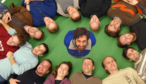
The second Young Engineers Satellite (YES2), involving nearly 500 university students from Australia, Japan, Europe and North America, launched on 14 September 2007 and came down safely in Kazakhstan on the 26th. The ESA’s Education Office is calling the mission a success:

The reentry capsule for the Foton-M3 spacecraft, which has been in low-Earth orbit for the last 12 days, successfully landed this morning in an uninhabited area 150 km south of the town of Kustanay in Kazakhstan, close to the Russian border, at 09:58 CEST, 13:58 local time.
 
The unmanned Foton spacecraft, which was launched on 14 September from Baikonur Cosmodrome, in Kazakhstan, carried a payload of 43 European experiments in a range of scientific disciplines – including fluid physics, biology, crystal growth, radiation exposure and exobiology.

The mission was intensively monitored throughout by 65 engineers and scientists located at ground stations at Esrange, in Kiruna, Sweden, and at the Russian flight control centre, TsUP, in Moscow, Russia. Thanks to a close cooperation with the Canadian Space Agency, ground stations in St. Hubert and Saskatoon were also used to receive data from the spacecraft. 
 
“I am extremely pleased with the success of the Foton-M3 mission,” says Josef Winter, Head of ESA’s Payload and Microgravity Platform Division. “All operations during the mission were flawless. The hard work and dedication of all involved has contributed to make this mission a success. I would like to congratulate our Russian counterparts and thank them for their outstanding cooperation.”

Helicopters were immediately at the landing site to start recovery operations, including the retrieval of experiment hardware. The European experiments will now be returned to the labs at ESA’s research and technology centre, ESTEC, in Noordwijk, the Netherlands, tomorrow evening. After further inspection at ESTEC the experiments will be returned to the scientific institutions where the data will be analysed over the coming months.
 
Only in-depth analysis will reveal the full extent of the scientific return of the mission, although data received during the flight already shows promising results – the Italian and US team responsible for the GRADFLEX (GRADient-Driven Fluctuation EXperiment) experiment received preliminary confirmation of a 10-year-old fluid science theory.

A further highlight of the mission was yesterday’s deployment of a small reentry capsule from the outside of the Foton spacecraft. The Second Young Engineers’ Satellite (YES2) experiment saw the release of the beachball-sized Fotino capsule from the end of a tether to demonstrate the smart possibility of returning small payloads to Earth.

"I am extremely satisfied that we could fly a very high number of experiments during the Foton-M3 mission and that they all worked out well. Some of them will even be further elaborated onboard the International Space Station," says Martin Zell, ESA’s Head of Research Operations for the Directorate of Human Spaceflight, Microgravity and Exploration.

 The experiment was some coverage in the almost-science press this week. Wired, for example:

The students’ critical moment came today, and so far it’s a qualified success. The payload, a small capsule dubbed “Fotino” was intended to be let out on a 18.6 mile, fishing line-thin tether before being released. But the process went more slowly than projected, and the little test capsule was cut loose by a preprogrammed command after just 5.2 miles.

European Space Agency scientists are currently tracking the little device to figure out where and how its parachute will bring it back to earth.

The mishaps may mean that the students’ tether system won’t find its way immediately into adoption for critical satellite or other launches. But the test gives space programs around the world new data on an innovative and potentially money-saving technique for orbital deployments.

They’re right about how cool this mission was. Here’s their animation:


Still no word on whether the prog-rock group Yes is comtemplating a copyright infringement complaint.