Cognitive Radio

The March issue of Scientific American provides an excellent overview of a new technology and its potential. Cognitive Radio: Smart radios and other new wireless devices will avoid transmission bottlenecks by switching instantly to nearby frequencies that they sense are clear.

Will the Rocket Car Blast Your Commute?

If you’re one of many commuters who spend countless hours in the car between work and home, you’ve probably seen more than your share of gridlock. Chances are at least once or twice you’ve closed your eyes and dreamed of your car sprouting rockets and wings to lift you far above the parking lot that used to be a freeway. Well, don’t go trading your drivers’ license for a pilot’s license just yet, but some of MIT’s "Aeronautics and Astronautics" students are working on making your rocket car dreams come true

Rocket Car

This summer, graduate students at the Massachusetts Institute of Technology will try to get an idea aloft that has intrigued people for decades: the flying car.

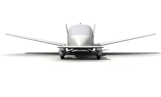
Terrafugia, a start-up created by Lemelson-MIT Student Prize winner Carl Dietrich and colleagues at MIT’s Department of Aeronautics and Astronautics, is aiming to show off what it calls the Transition "personal air vehicle," an SUV with retractable wings, to the EAA AirVenture Conference in Oshkosh, Wis., at the end of July.

The Transition is designed for 100- to 500-mile jumps. It will carry two people and luggage on a single tank of premium unleaded gas. It will also come with an electric calculator (to help fine-tune weight distribution), airbags, aerodynamic bumpers and of course a GPS (Global Positioning System) navigation unit.

Right now, there’s no prototype (I told you not to get your hopes up yet) and according to the article the company doesn’t plan to have one of these in the air before 2009 or 2010. Meanwhile, you can start saving up for one, and check out the pictures of their (one-fifth scale) wind tunnel model. While you’re at it, why not print out a copy and attach it to your sun visor just to have something concrete to dream about while you wait for the traffic to inch forward again?

EchoStar X is Up

After two delays, the EchoStar X satellite was launched yesterday when "a Sea Launch Zenit-3SL rocket lifted off from the Odyssey Launch Platform at 3:35pm PST:"

ll phases of the flight profile performed as expected. The mission ended with spacecraft separation from the Block DM upper stage, placing the EchoStar X communications satellite into a Geosynchronous Transfer Orbit. A ground station in Uralla, Australia acquired the spacecraft signal. All systems are operating nominally.

You can watch an archived webcast of the launch here. Space.com also has a report on the launch.

Space Archaeology?

Who knew that NASA did archaeology? Unless someone’s sifting through the sands of some distant planet for signs of ancient intelligent life, I’ve always thought of archeology as the earthbound realm of the Discovery Channel and maybe Indiana Jones. That is, at least until I read that NASA helped uncover lost Maya ruins in the Central American jungle. 

Remains of the ancient Maya culture, mysteriously destroyed at the height of its reign in the ninth century, have been hidden in the rainforests of Central America for more than 1,000 years. Now, NASA and University of New Hampshire scientists are using space- and aircraft-based “remote-sensing” technology to uncover those ruins, using the chemical signature of the civilization’s ancient building materials.

NASA archaeologist Tom Sever and scientist Dan Irwin, both from NASA’s Marshall Space Flight Center in Huntsville, Ala., are teaming with William Saturno, an archaeologist at the University of New Hampshire, to locate the ruins of the ancient culture. Saturno discovered the oldest known intact Maya mural at the site in 2001.

… Sever has explored the capacity of remote sensing technology and the science of collecting information about the Earth’s surface using aerial or space-based photography to serve archeology. He and Irwin provided Saturno with high-resolution commercial satellite images of the rainforest, and collected data from NASA’s Airborne Synthetic Aperture Radar, an instrument flown aboard a high-altitude weather plane, capable of penetrating clouds, snow and forest canopies.

These resulting Earth observations have helped the team survey an uncharted region around San Bartolo, Guatemala. They discovered a correlation between the color and reflectivity of the vegetation seen in the images – their “signature,” which is captured by instruments measuring light in the visible and near-infrared spectrums – and the location of known archaeological sites.

My first thought was that if it’s possible to be an archaeologist without having to tromp around deserts and rain forests, I might start considering a new line of work. (Those mummy-related specials on Discovery and TLC inspire me.) I did a little searching online and found a bit more information about the research team and their research in Petén, Guatemala. Turns out, it’s still archaeology, so they still had to hack through the jungle — using satellite images to guide them — to “ground test” the data. They uncovered a series of ancient sites, right where the data and images predicted they’d be. 

So much for doing archaeology from a nice, air conditioned, indoor space — which I’m guessing were the conditions at the National Space Science and Technology Center, where Sever and Irwin conducted their space-based research before heading out into the field. Sever and Irwin can use satellites to lead them to ancient ruins, and I’ll wait for the same to beam their findings down to my living room.
NASA Satellite Technology Helps Fight Invasive Plant Species

If you’ve spent much time on rivers in the Southwest, you know that tamarisk (also known as saltcedar) is a much-hated invasive species– and a threat to the region’s water supply.

Introduced from Eurasia in the early 1900s as an ornamental and erosion-control shrub, it has since spread through most of the Southwest’s riverways (and as far east as Minnesota), choking out native species and crowding out the good cottonwood-shaded beaches that river rafters favor. As well:

The U.S. Department of Agriculture recently identified saltcedar as one of the most harmful invasive species in the United States, because the plant’s long roots tap into underground aquifers. Its groundwater absorbing qualities may be adding to the severity of the drought in the western United States. Saltcedar also increases the salt concentration of the soil and degrades habitats for native species along river systems.

But even low-tech ecological conundrums can be aided by satellite technology. NASA reports:

Products based on NASA Earth observations and a new Internet-based decision tool are providing information to help land and water managers combat tamarisk (saltcedar)… This decision tool, called the Invasive Species Forecasting System (ISFS), is being used at the U.S. Geological Survey (USGS) National Institute of Invasive Species Science in Fort Collins, Colo. It is the result of combining USGS science and NASA Earth observations, software engineering and high-performance computing expertise….. The ISFS uses observations and science data products from NASA’s Terra, Aqua and Earth Observing-1 satellites and the USGS-operated Landsat satellites, together with field data from government and non-government contributors. The satellites observe and measure sunlight reflected by plants and their environments. The satellites lock in on unique aspects of the reflected light to determine saltcedar’s locations and habitats vulnerable to invasion. During the plant’s blooming season, ISFS-generated maps predicting locations match observations of it in the field. These predictive maps are an important new tool for land managers involved with saltcedar-related control and restoration efforts. "Satellite data coupled with computer modeling helps us understand where saltcedar is likely to be growing, even in remote locations that field researchers cannot easily reach," said John Schnase, principal investigator of the ISFS project at NASA’s Goddard Space Flight Center, Greenbelt, Md.

3-D Imaging with Lasers

Japan’s National Institute of Advanced Industrial Science and Technology has developed free-standing three-dimensional displays, using a laser to make the gases in the air emit light in a 3-meter cube.

You can read more about it here.


Alphabet Soup

One of the things I came away with at Satellite2006 (besides some pretty cool pictures) was a head full of acronyms that I still haven’t sorted out. I was reminded of that when I came across CNet’s “Wireless Alphabet Soup” post. I did a little poking around online, and found even more. I’m not sure how many of these I saw or heard at the conference, but it bears more than a passing resemblance to alphabet soup:

3G, 3GPP, BREW, BSS, CDMA, CDMA2000, CDPD, CME-CU, DVB-H, EDGE, ESS, EV-DO, FLO, GGSN, GPRS, GSM, HDML, HIPERLAN, HSCSD, HSDPA, HSUPA, IM1, MAC, MIMO, PKI, RAN, RASP, RU12, SGSN, TDMA, TD-SCDMA, UMTS, WAP, WCDMA, WEP, WIBRO, WIM, WLAN, WiMax, WTLS

I’m sure there are more that I’ve never even heard of before, but this is enough to wrap my brain around for now. If you know any that got left out, drop ’em in the comments. (And help a newbie out by throwing in a definition or two.)

Oh, and just for fun I made up a few of my own and tossed them in. Can ya find ’em? If so, good. Take notes. I have a feeling there might be a quiz of some sort later.

EchoStar Launch Delayed Again

The Sea Launch of the EchoStar satellite (reported below) was scrubbed again on Sunday. "The Sea Launch team is currently working an issue at the launch site," according to the Sea Launch website. We’ll update our readers when the launch has been rescheduled. Who said Rocket Science was easy?

Satellite Used to Study Effects of General Relativity

The Tartan Online, Carnegie-Mellon’s student newspaper, chooses Gravity Probe B as its "Experiment of the Week":

Gravity Probe B, a well-endowed NASA/Stanford satellite, is at this moment orbiting the Earth. The satellite’s main feature is its four perfectly spherical, shiny balls. These balls serve as the world’s most perfect gyroscopes, used in an extraordinarily complex and expensive experiment to observe the effects of general relativity…. Einstein’s theory predicts that a rotating massive body should slowly “frame-drag” space and time around with it. Over time, this dragging effect should push the gyroscope’s axis of rotation about 40 milliarc-seconds out of alignment. That’s the width of a human hair as seen from 10 miles. The probe intends to measure this to an accuracy of one percent.

Stanford University, which is working with NASA on the mission, has a mission status webpage that is worth checking out. Also be sure to check out the vehicle tour and the image gallery, featuring schematics of the satellite and pictures of the launch. What other satellite mission websites have you found? Post a link in the comment, or post your own blog entry, and we may promote your link to the homepage.

EchoStar Launch Today

Here’s an update on the EchoStar launch, which was scrubbed on Wednesday:

After halting the countdown for launch on February 8, Sea Launch is now preparing for the launch of the EchoStar X satellite on Sunday, February 12, at the opening of a 49-minute launch window, at 3:35pm PST (23:35 GMT).

You can check out the live webcam here.