Cirque du Espace


Guy Laliberté may not be happy about his biography by Ian Halperin, but he must be ecstatic about going into space in September:

He is scheduled for launch September 30 aboard the Soyuz TMA-16 spacecraft from the Baikonur Cosmodrome in Kazakhstan. His crewmates will be rookie spacecraft commander Maxim Suraev, a colonel in the Russian air force, and NASA astronaut Jeffrey Williams, a shuttle veteran making his second long-duration voyage on the station.

Laliberté will spend nine days aboard the lab complex before returning to Earth aboard the Soyuz TMA-14 capsule October 11 with outgoing station commander Gennady Padalka and NASA flight engineer Michael Barratt. Williams and Suraev will remain aboard the space station as part of the Expedition 21 crew.

"First of all, I would like to say how privileged and honored I am to be flying with these two men," Laliberté said in Houston, where he is training for his upcoming flight. "I feel totally confident. They have been generous sharing with me their knowledge and their advice."

And he’s only paying $35 million for the flight. That will pay quite a few rocket scientist salaries.

Think of the ideas he’ll have for his Cirque du Soleil shows after he return. Zero gravity, anyone?


DIY Friday: Head-Mounted Water Cannon

So this may not be related to rocket science, but it is an awesome little project. Awesome. A head-mounted water cannon, courtesy of Make and John Young:

Let’s face it: At some point this summer, you’re going to be in a water fight. Whether it’s at a family barbecue or an office picnic, some 12-year-old is going to leer at you from behind 25 bucks worth of store-bought plastic, and that little punk is going to think that the orange and blue Mega Awesome Hydrolator 9000 they’re clutching is the last word, the ultima ration regnum, in neighborhood water warfare.

Think again, punk. With about two hours of effort and the parts listed on the next page, you can hack together a water weapon of such power, such style, such extraordinary and exuberant overkill, that you’ll be out of the store-bought leagues forever. Lock yourself in the garage, play the A-Team theme, and emerge at the end of your build montage with a pressurized, stainless steel, head-mounted water cannon that packs five gallons of icy-cold water at 100 psi.

 This video has it all:


Total Solar Eclipse


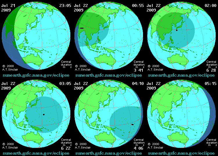
Today’s news in Asia is about the total solar eclipse, the longest of the century:

The path of the Moon’s umbral shadow begins in India and crosses through Nepal, Bangladesh, Bhutan, Myanmar and China. After leaving mainland Asia, the path crosses Japan’s Ryukyu Islands and curves southeast through the Pacific Ocean where the maximum duration of totality reaches 6 min 39 s. A partial eclipse is seen within the much broader path of the Moon’s penumbral shadow, which includes most of eastern Asia, Indonesia, and the Pacific Ocean.


Check out Xinhua’s photo gallery, and, if you can bear it, this TV news report…


Jupiter Collision

Australian Anthony Wesley has discovered an impact on Jupiter, and confirmed by NASA’s JPL. The local story, via the Sydney Morning Herald:

 An amateur Australian astronomer has set the space-watching world on fire after discovering that a rare comet or asteroid had crashed into Jupiter, leaving an impact the size of Earth.

Anthony Wesley, 44, a computer programmer from Murrumbateman, a village north of Canberra, made the discovery about 1am yesterday using his backyard 14.5-inch reflecting telescope.

The impact would have occurred no more than two days earlier and will only be visible for another few days.


 Check out Sky and Telescope’s Red Spot Transit Table for reference.


Yeah, reminds me of the scene in 2001: A Space Odyssey, Jupiter and Beyond the Infinite…


Welcome Back Horowitz

While I was away earlier this month, Andy Pasztor wrote a piece in the WSJ on former SES AMERICOM CEO Ed Horowitz teaming up with former International Launch Services CEO Mark Albrecht to form U.S. Space:

A clutch of former Pentagon brass is helping to start a company that offers a new service: satellites intended solely for military communications that would be built, launched and owned by private investors.

The new company, called U.S. Space LLC, attempts to meet a need that the U.S. military has struggled to fill. As U.S. forces deploy to out-of-the-way regions, the Pentagon frequently needs more satellite capacity for communications and distribution of video surveillance than it can get its hands on.

The military’s own satellites are expensive, and often take too long to deploy to satisfy fast-changing battlefield needs. Meanwhile, the military hasn’t always been able to lease sufficient bandwith on traditional commercial satellites, particularly in remote areas such as Afghanistan.

The new company intends to build and launch relatively small and inexpensive commercial satellites that would be optimized for military use and leased only to military customers, according to Mark Albrecht, the company’s chairman and co-founder.

Backers said the price of the satellites would be held down by keeping them small, modular and relatively basic, without tailoring them for special needs and piling on bells and whistles.

"This is absolutely responsive" to the Pentagon’s needs for quickly supplementing current capacity wherever it’s needed, said Mr. Albrecht, a former head of Lockheed Martin Corp.’s international rocket business.

The company’s board members count three former Air Force generals, including retired Lt. Gen. Michael Hamel, who until recently served as the military’s top uniformed space-acquisition official; retired Major General James Armor, a former space policy maker; retired Major General Craig Weston, who is also the president and chief executive of U.S. Space. The company’s backers include firms headed by former Attorney General John Ashcroft and former Defense Secretary William Cohen.

Each proposed high-altitude satellite is envisioned to cost less than half of the roughly $350 million price tag for building and launching a large, top-of-the-line commercial satellite. The Pentagon and various national-security customers already lease significant commercial capacity, often at expensive spot rates that by some estimates amount to more than $800 million annually.

In addition to being less costly, the venture aims to be more flexible because the in-orbit locations and transmission frequencies specifically will be intended for military uses.

The U.S. Space models are intended to be ready for service in roughly three years, versus a decade or more in development for most Pentagon satellites.

The project is risky, partly because no firm financing or contracts to supply capacity have been signed. The Pentagon is notorious for balking at long-term satellite leasing arrangements.

But military brass "have really endorsed" the commercial approach and "encouraged us to continue the discussions," said Edward Horowitz, a U.S. Space co-founder and former president of the U.S. unit of global satellite-services giant SES Global.

Industrial firms backing the venture include a group of second-tier aerospace contractors led by Orbital Sciences Corp., which is in line to build the satellites and launch them with a beefed-up version of its Minotaur rockets.

Ed was the inspiration and force behind this blog, and Mark was at helm of ILS when they began publishing their launch blogs. They will surely impact the commercial space business.


STS-127 Launch


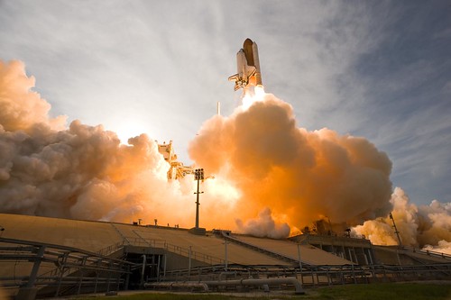
At last, the STS-127 mission launches into space. Shuttle launches are still the best to watch:


Broadband Stimulus in Space


Terrestar-1 was launched a couple of weeks ago. In-orbit testing is going well, and the antenna is up. Wish we could say the same about the Solaris Mobile bird.

As we’ve blogged before, the company behind it has an interesting propostion: a diverse path for communicating via smartphone.  No signal? No problem: connect via satellite.

More interesting is they’ll be one of many satcom-based communications companies going after some of the US$7.2 billion set aside for broadband, as reported by the Wall Street Journal:

 The launch is significant because it could make the case to policymakers, who may have government grants or business to offer, that satellite Internet service is a viable alternative to cable or cellular hookups.

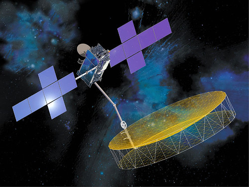
The sheer size of TerreStar’s satellite, which has a 60-foot antenna, will ensure that military personnel, emergency responders, and rural customers are always connected, said TerreStar President Jeff Epstein.

TerreStar has developed a smart phone that operates both on its satellite network and a traditional cellular network. The company has secured a roaming agreement with AT&T Inc. (T), and it could pursue similar agreements with other wireless carriers.

"Off the network grid, you can make calls via the satellite," Epstein said. "It’s a redundant path."

TerreStar will be among the first satellite carriers to offer Internet speeds that are comparable to high-speed WiFi or cellular broadband. That could make the company eligible for some of the $7.2 billion in economic stimulus money for high-speed Internet connections in unserved and rural areas.

Right now, government officials and industry analysts say satellite Internet service is too spotty and slow to be a good candidate for the government money.

The advantage of satellite service, however, is that it can cover much wider swaths of the country than other types of connections.

With a robust network, satellite could become the ideal method to deliver high-speed Internet to sparsely populated areas, a top priority of President Barack Obama.

But TerreStar’s Internet service rollout might be too late for an economic stimulus subsidy. By law, the government Internet grant money must be distributed by the end of September 2010, which means grant makers will start allocating the last round of funds sometime next spring.

Before TerreStar can start selling voice and data service, it has to test its network in orbit. Epstein said he wants to complete that testing by the end of the year.

SkyTerra Communications Inc. (SKYT) has similar plans to offer mobile Internet services. It announced earlier this month that it will launch one of two next-generation satellites in the first half of 2010.

Both SkyTerra and TerreStar have agreements with Qualcomm Inc. (QCOM) and Infineon Technologies AG (IFNNY) to develop more models of regular-size satellite-cellular devices.

More power to them!

Here’s the launch video, courtesy of Space Systems/Loral


Good One


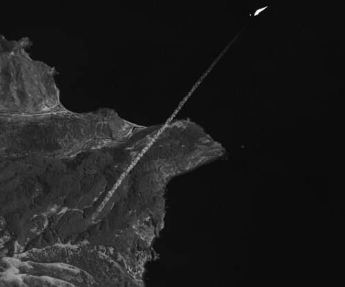
Nice launch from Omelek Island by SpaceX this morning of the Malaysian Razaksat aboard the Falcon I rocket (Flight V). The news summary, via Bernama:

RazakSAT, Malaysia’s second remote sensing satellite, blasted off into space at 11.35 am Malaysian time from Kwajalein Atoll in the Pacific Ocean’s Marshall Islands.

Twenty minutes into launch, the 180kg satellite entered the Near Equatorial Orbit (NEqO) to become the world’s first remote sensing satellite launched into the NEqO, the Ministry of Science, Technology and Innovation said in a statement here Tuesday.

The launch at Omelek Island using Space Exploration Technologies (SpaceX)’s launcher Falcon 1 went smoothly after a four hour delay due to the need to fulfill some technical requirements.

The ministry said that one-and-a-half hours into the launch, initial contact was established by the National Space Agency at Sungei Lang in Banting with Razaksat.

Science, Technology and Innovation Minister Datuk Dr Maximus Ongkili and officials from the ministry and agency Astronautic Technology (M) Sdn Bhd were in Guam to witness the launch via webcasting.

Simultaneously, the ministry officials led by Deputy Minister Fadillah Yusof watched the launch and held a teleconference with the group in Guam via webcasting at the National Space Agency in Banting, Selangor.

There was an air of jubilance when the satellite, named after Malaysia’s second prime minister Tun Abdul Razak Hussein, blasted into space after a drizzle and strong wind at the launch site.

Dr Ongkili said the launch was historical not only for Malaysia but the world. The satellite will orbit the NEqO at an altitude of nominal 685km.

"I congratulate ATSB for building Malaysia’s own RazakSAT 1Malaysia World First NEqO Satellite," Dr Ongkili said.

RazakSAT carries a high resolution camera that can take images from space for different applications to benefit not only Malaysia, but countries along the equatorial region.

The orbital location will enable an increased frequency of image observation, and the images can be applied to precision farming, landscape mapping, forest biomass, marine spatial planning, disaster mitigation, urban and road network planning.

Dr Ongkili said that while other satellites operate on polar orbit (Sun Synchronous Orbit), the RazakSAT® operates at NEqO and will cover 70 percent of the oceans, where weather phenomena such as La Nina originate.

"This will allow scientists to study and monitor various critical factors that will contribute significantly to science," he said.

Several countries in Asia, the African continent and Latin America have expressed interest in utilising the images captured by RazakSAT, he said.

Malaysia, he said, would also be offering the data to contribute to the field of knowledge to benefit societies all over the equatorial region.

Remote Sensing Malaysia, an agency within the ministry, would be responsible for receiving the data from RazakSAT and developing its applications, Dr Ongkili said.

RazakSAT is a continuation of the TiungSAT-1 programme, the country’s first remote sensing satellite launched in 2000. However, RazakSAT is a fully functional satellite in monitoring the earth’s surface and environment.

Dr Ongkili is confident the achievement would propel and inspire the ministry’s agencies and Malaysians at large to continue to strive to be innovative and creative, particularly as the country celebrates the Year of Creativity and Innovation next year.

"We aim to make a mark for Malaysia in the world of science and innovation, not just by exploring the borderless world but to go beyond, into space," he added.

He also announced that SpaceX has agreed to launch the two micro-satellites CubeSAT and InnoSAT, meant for educational purposes, next year on Falcon 9.

CubeSAT was developed by ATSB while InnoSAT by three local universities, namely Universiti Sains Malaysia, Universiti Teknologi Malaysia and Universiti Malaysia Perlis.

Dr Ongkili attributed the success of RazakSAt to the national leaders – former prime ministers Tun Mahathir Mohamad and Tun Abdullah Ahmad Badawi as well as current Prime Minister Datuk Seri Najib Tun Razak – for their unwavering support, confidence and visionary leadership in innovating RazakSAT.

The RazakSAT® satellite will be operated through its ground segment in Malaysia, consisting of a Mission Control Station (MCS) and Image Receiving and Processing Station (IRPS).

SpaceFlightNow.com has a better quote:

"We nailed the orbit to well within target parameters, pretty much a bullseye," Elon Musk, founder and CEO of SpaceX. 


Today being Bastille Day, can’t help to reference Steve Martin’s role as Inspector Clouseau: "Good one." Here’s the trailer, in French:




DIY Friday: Satellite Dish Bird Feeder


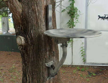
Here’s a simple project I might try with my old reflector and mount: a bird thing. Via Instructables:

Have you ever wondered how many unused satellite dishes are floating around aimlessly out there? After being disconnected, they seem to have no apparent function other than occupying valuable storage space and being mostly ugly? The object of this exercise is to offer a simple way to make an environmentally friendly use of one of the thousands of satellite dishes that have found their way into the landfills, attics and garages of those who have had their service disconnected.

The satellite companies typically require the user to return the receiver but to leave the dish and its hardware behind. For those who have access to the removal of this unsightly hardware, here is a garden friendly way to put it to use as a free, rugged, and weather resistant birdbath. Keep in mind that if you plan to install it on a tree you will have to fiddle around a bit to find a level spot to secure it and you may even need to use wooden blocks or shims in extreme cases. The idea is to keep it reasonably level to allow water to seek its own level in a more or less uniform way.

We’ve had many projects for old dishes on this blog (wifi, cantenna, gazebo, solar cooker), but I like this one for its simplicity and subtle geek appeal.

 
This Satellite Dish is for the BirdsMore DIY How To Projects

ICESAT, Baby!


Does Vanila Ice care about "global warming?" He probably does. As do many others, adding drama to real science.

NASA’s been at it, too, but only now are we talking about a dramatic change in the Arctic ice. The spacecraft, ICESat, uses laser light to measure the Earth’s ice:

ICESat is designed to observe seasonal and interannual variations in surface elevation that are caused by variations in precipitation (snowfall) and surface melting. These data will be used in energy-balance models and to test the results of atmospheric circulation models used to predict climate-induced changes. ICESat should detect changes in mass balance expected for each 1 degree change in polar temperatures (depends on sensitivity estimate). ICESat measurements are essential for making reliable assessments of whether future changes in ice volume will add to the sea level rise, which is already occurring due to the warming and thermal expansion of the oceans and worldwide melting of small glaciers, or whether the ice sheets might grow and absorb a significant part of the predicted sea level rise.

Now comes the drama, from the Great White North, via Canada.com:

Arctic sea ice thinned dramatically between the winters of 2004 and 2008, with thin seasonal ice replacing thick older ice as the dominant type for the first time on record, data from a NASA Earth-orbiting spacecraft has revealed.

Calling it the most comprehensive survey to date, scientists from NASA and the University of Washington say the information provides "further evidence for the rapid, ongoing transformation of the Arctic’s ice cover."

"The thickness and volume of the ice cover is continuing to decline, making the ice more vulnerable to continued shrinkage," NASA research team leader Ron Kwok said. "Our data will help scientists better understand how fast the volume of Arctic ice is decreasing and how soon we might see a nearly ice-free Arctic in the summer."

Using measurements from NASA’s Ice, Cloud and Land elevation satellite — ICESat — scientists found that overall Arctic sea ice thinned nearly 18 centimetres a year for a total of 72 centimetres over four years.

The data also shows that the total area covered by the thicker, older "multi-year" ice that has survived one or more summers shrank by 42 per cent.

Kwok said ICESat allows scientists to monitor ice thickness and volume changes over the entire Arctic Ocean for the first time.

 Check out the video…