Archive for the ‘Astronomy’ Category

Canadians Help Pakistan Buy Chinese Satellite

Monday, October 20th, 2008

Pakistan just bought a shiny new satellite from China, with the help of Canadian company Telesat.

Pakistan says the satellite, called PakSat-1R, for Pakistan in 2011, will be used for domestic telecommunication and broadcast services. Contracts for the deal were signed last week with both the Pakistani President Asif Ali Zardari and Chinese President Hu Jintao present.

The satellite’s chief contractor is the China Great Wall Industry Corp. This is the third time that the corporation has launched a satellite for another country. In 2007, two satellites were launched for Nigeria.

China has also signed a deal to launch a communications satellite for Venezuela. Venezuelan President Hugo Chavez praised the project on a recent visit to China:

Venezuela’s Presidential Office also issued a statement in praise of the upcoming launch of the VENESAT-1 satellite, that will transmit telephone, Internet, video conferencing and other signals throughout the region from the Caribbean to Paraguay on South America’s southern tip.

More than 100 Venezuelans have been trained in China to operate the satellite, the office said.

"We will have a tool allowing us to say that there are no borders, or places in our region we cannot reach," the statement quoted Science and Technology Minister Nuris Orihuela, who was accompanying Chavez on his visit, as saying.

The satellite, also known as the Simon Bolivar after the Venezuelan-born South American independence hero, will be launched on Nov. 1 from western China’s Xichang launch site aboard a Chinese Long March 3B rocket.

The U.S. sees cause for concern in the rise of China’s satellite industry. The Defense Secretary has been charged with reviewing whether allowing companies with US defense contracts to launch satellites in China poses a national security threat. At the center of the debate is a bill signed into law just last week, the "Duncan Hunter National Defense Authorization Act for Fiscal Year 2009".

Satellite manufacturer Thales Alenia Space of Europe has built satellites that are free of U.S. parts, which are effectively barred from being shipped to China under U.S. International Traffic in Arms Regulations (ITAR) rules. Another company, OHB Technology of Germany, is designing a new satellite line with European Space Agency funds that is intended to include a so-called ITAR-free option for customers wanting to launch from China.

Space Systems/Loral, a major U.S. commercial satellite builder, has complained to U.S. government authorities that the ITAR-free option gives these European contractors an advantage because China’s rockets are less expensive to use than U.S., European or Japanese rockets.

Solar Power From Space

Tuesday, October 14th, 2008

The Washington Post had an intriguing article on Sunday, titled An Energy Fix Written in the Stars:

 Solar energy is a favorite of environmentalists, but it works only when the sun is shining. But that’s the trick. There is a place where the sun never sets, and a way to use solar energy for power generation 24 hours a day, 365 days a year: Put the solar cells in space, in high orbits where they’d be in sunshine all the time.

You do it with the solar power satellite (SPS), a concept invented by Peter Glaser in 1968. The idea is simple: You build large assemblages of solar cells in space, where they convert sunlight into electricity and beam it to receiving stations on the ground.

The solar power satellite is the ultimate clean energy source. It doesn’t burn an ounce of fuel. And a single SPS could deliver five to 10 gigawatts of energy to the ground continually. Consider that the total electrical-generation capacity of the entire state of California is 4.4 gigawatts.

Conservative estimates have shown that an SPS could deliver electricity at a cost to the consumer of eight to 10 cents per kilowatt hour. That’s about the same as costs associated with conventional power generation stations. And operating costs would drop as more orbital platforms are constructed and the price of components, such as solar voltaic cells, is reduced. Solar power satellites could lower the average taxpayer’s electric bills while providing vastly more electricity.

They would be big — a mile or more across. Building them in space would be a challenge, but not an insurmountable one: We already know how to construct the International Space Station, which is about the size of a football field. And the SPS doesn’t require any new inventions. We have the technology at hand.


The SPS was granted a pantent in 1973, according to Wikipedia:

In 1973 Peter Glaser was granted U.S. patent number 3,781,647 for his method of transmitting power over long distances (eg, from an SPS to the Earth’s surface) using microwaves from a very large (up to one square kilometer) antenna on the satellite to a much larger one on the ground, now known as a rectenna.

What’s a rectenna, you ask?

A rectenna is a rectifying antenna, a special type of antenna that is used to directly convert microwave energy into DC electricity. Its elements are usually arranged in a multi element phased array with a mesh pattern reflector element to make it directional.

A simple rectenna can be constructed from a Schottky diode placed between antenna dipoles. The diode rectifies the current induced in the antenna by the microwaves. Schottky diodes are used because they have the lowest voltage drop and highest speed and therefore waste the least amount of power due to conduction and switching.

Rectennas are highly efficient at converting microwave energy to electricity. In laboratory environments, efficiencies above 90% have been observed with regularity. Some experimentation has been done with inverse rectennas, converting electricity into microwave energy, but efficiencies are much lower—only in the area of 1%.

Here’s a good article from last July’s Scientific American on SPS in Japan, which also cites the Japanese animated series "Mobile Suit Gundam," which has humanity turning to space-based solar power in the year 2307:


Want to learn more? Check out the Citizens for Space Based Power blog.

Looks Like Kutztown

Friday, October 10th, 2008


Copyright © 2008 GeoEye


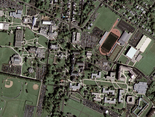
GeoEye-1’s first image released of Kutztown University in Pennsylvania:

GeoEye, Inc. (NASDAQ: GEOY), a premier provider of satellite, aerial and geospatial information, released today the first, color half-meter ground resolution image taken from its GeoEye-1 satellite. The satellite has been undergoing calibration and check-out since it was launched on Sept. 6 from Vandenberg Air Force Base in Calif. The Company will begin selling GeoEye-1 imagery products later this fall.

The Kutztown University image shows the campus, which includes academic buildings, parking lots, roads, athletic fields and the track-and-field facility. The image was collected at 12:00 p.m. EDT on Oct. 7, 2008 while GeoEye-1 was moving north to south in a 423-mile-high (681 km) orbit over the eastern seaboard of the U.S. at a speed of four-and-one-half miles per second. GeoEye-1 was built by General Dynamics Advanced Information Systems in Gilbert, Ariz. The imaging system was built by ITT in Rochester, NY.


Airborne Broadband Bacchanal

Wednesday, October 1st, 2008


About a week after Labor Day, ARINC introduced new Caribbean coverage for SKYLink, an in-flight broadband service for business jets:

The new Caribbean coverage area means users of the SKYLink network will be able to fly from Europe to North America, across the Caribbean, and on to Central and South America, without losing access to important e-mail or Internet applications. To encourage customers to take part in the coverage tests, ARINC Direct suspended roaming charges in the new region through July 21, 2008. Customer feedback was used to adjust satellite coverage and to map signal strength across the region.

The new coverage includes the Bahamas, Jamaica, Cuba, Haiti, the Dominican Republic, Puerto Rico, the Lesser Antilles, Trinidad-Tobago; Belize, Guatemala, Honduras, El Salvador, Nicaragua, Costa Rica, Panama, Colombia, Ecuador, northern Peru, northern Bolivia, Venezuela, Guyana, and part of Surinam.

eXchange with service by SKYLink is the only communications system for business jets offering true broadband Internet speeds—as high as 3.5 Mbps to the aircraft. Customers have access to e-mail, corporate intranet (VPN), the Web, flat-rate Voice over IP (VoIP) global telephone service, and videoconferencing. eXchange also provides e-mail and data capability for personal Wi-Fi enabled smartphones in the cabin.


Really cool how Rockwell-Collins integrates it all:

Business travelers will experience real-time, two-way broadband connectivity with secure access to e-mail services, Internet browsing, access to Virtual Private Networks (VPN), and options for Voice over IP (VoIP) telephone service and videoconferencing. eXchange also enables data connectivity to select Wi-Fi enabled smartphones, such as RIM’s Blackberry models 8320 and 8820, providing travelers with access to e-mail and other smartphone data services.

Thanks to the AMC-21 satellite’s dedicated Caribbean Ku-band beam — and new mobile platform — local satcom Internet companies like Caribbetech and mobile services like KVH have new opportunities to pursue.

Satellite Internet Making Inroads on the Backroads

Tuesday, September 30th, 2008

It’s hard to believe for some of us who think of dial-up internet as a thing of the past, but up to 10 million Americans who live in our nation’s most remote places still don’t have the option of DSL or cable internet.

But dial up won’t suffice in today’s age of YouTube and World of Warcraft, so what to do?

The answer is satellite broadband Internet. 

We’ve written in the past about several of the players in the market, such as Wild Blue, HughesNet, and Spacenet’s Starband.  But today we want to focus on SkyWay USA, which touts itself as "rural America’s low-cost satellite provider."


For just $49 in equipment costs (after a rebate) and a monthly basic subscription of $29.95, you can be up and running with SkyWay USA in a matter of days. Installation is so easy, according to this press release (caution if you’re still on dial-up: opens in PDF) that Skyway claims they’ve even had a 69 year old grandmother install the system.

So how does it work?

Skyways use a hybrid or combination model, using your phone line for sending commands (upload) and satellite for content (download).

For capacity, they use Echostar Fixed Satellite Services — at least according to MarketWatch. (On their own website, SkyWay says it is partnering with SES Americom.)

FSS is the division of EchoStar that uses DISH Network’s excess capacity. Dean Olmstead,  who was behind the AMERICOM2Home concept, notes that SkyWay USA will be using both the Ku- and Ka-band capacity of Echostar FSS.  

Money Launch for SpaceX

Monday, September 29th, 2008


SpaceX did it:

Space Exploration Technologies Corp. (SpaceX) announces that Flight 4 of the Falcon 1 launch vehicle has successfully launched and achieved Earth orbit. With this key milestone, Falcon 1 becomes the first privately developed liquid fuel rocket to orbit the Earth.

"This is a great day for SpaceX and the culmination of an enormous amount of work by a great team," said Elon Musk, CEO and CTO of SpaceX. "The data shows we achieved a super precise orbit insertion—middle of the bull’s-eye — and then went on to coast and restart the second stage, which was icing on the cake."

Falcon 1, designed from the ground up by SpaceX, lifted off at 4:15 p.m. (PDT) / 23:15 (UTC) from the Reagan Test Site (RTS) on Omelek Island at the U.S. Army Kwajalein Atoll (USAKA) in the Central Pacific, about 2,500 miles southwest of Hawaii.

Preliminary data indicates that Falcon 1 achieved an elliptical orbit of 500 km by 700 km, 9.2 degrees inclination—exactly as targeted.

Falcon 1 carried into orbit a payload mass simulator of approximately 165 kg (364 lbs), designed and built by SpaceX, specifically for this mission. Consisting of a hexagonal aluminum alloy chamber 1.5 meters (5 feet) tall, the payload remains attached to the second stage as it orbits Earth.

 Here’s the video:


Noah Schactman brings light to a very interesting perspective: how this impacts launch costs and who controls entry into space. This could be a real game-changer:

Space Exploration Technologies, or SpaceX, is promising to cut that $10,000-per-pound price in half. No wonder the Air Force has committed more than $100 million to the company, founded by PayPal’s Elon Musk. Darpa has made major investments, as well. "The military now has a stick to poke and prod the traditional big launch providers (Boeing and Lockheed Martin) into actually being competitive and saving the taxpayer money instead of just sucking off the government teat," former Air Force space officer Brian Weeden tells Danger Room.

But that stick only gets sharp if SpaceX can pull off the launch trick more than once. The company’s first three efforts were disasters. And there’s no guarantee the next three won’t be disasters, too. "Musk will need 20 or so launches before he knows how reliable his technology is — and how much it really costs," Hoffman wrote. And even if Musk can get these relatively-simple, relatively-small Falcon 1 rocket launches together, the real test will be whether the heavier, farther-reaching Falcon 9s will work out as planned.

It’s not just American launch costs that could go down. The next SpaceX rocket is supposed to carry a Malaysian reconaissance satellite into orbit. "This could be the beginning of a general diffusion of on-orbit capability of all sorts and a loss of U.S. ability to call the shots in space," says long time satellite-watcher (and former CIA officer) Allen Thomson.

Satphones for the Masses

Thursday, September 25th, 2008

Qualcomm is teaming up with SkyTerra’s Mobile Satellite Ventures (MSV) and ICO Global Communications to integrate satellite communications into mass-market cellular handsets, Wireless Week reports:

Under the agreement, Qualcomm will integrate satellite and cellular communication technology by developing a satellite protocol and including it in the firmware of select Qualcomm multimode baseband chips.  Qualcomm also plans to support the L- and S-Band frequencies, in which MSV and ICO operate, in select RF processors.

In essence, the same mobile chipsets at the heart of wireless devices will let handset makers produce satellite-capable devices at comparable scale and cost.

I guess this might mean the end of the "can you hear me now?" commercials, eh?

The quality of the players in this venture (no pun intended) bode well for its ultimate outcome. Qualcomm developed its satellite-based asset-tracking service, OmniTRACS, years before GPS technology became commercially available. OmniTRACS  is what’s inside those little white domes you see on on Sears trucks.


Here’s a video of how it works: 

Qualcomm is also working on the Google Android phone, which is supported by the Android open-source operating system and intended as a major competitor to the Apple iPhone:


Qualcomm is likely to face stiff competition in the future from chipmakers who want in on the Android action. 

Perhaps we’ll see similar functionality as what’s found in the Thuraya system, with the Android switching between GSM and satellite as required?

Time will tell.


Canada’s New Friend

Monday, September 22nd, 2008


Telesat’s Nimiq 4 satellite was launched by International Launch Services over the weekend, which is already fully leased to Bell TV.


The news, via RIA Novosti:

The rocket was successfully launched from the Baikonur space center in Kazakhstan at 01:48 Moscow time (21:48 GMT)

"The Nimiq-4 satellite was successfully orbited," a source in the Khrunichev State Research and Production Center said.

The contract to launch the satellite was signed last April by Canada’s satellite communications company Telesat and International Launch Services (ILS), a U.S.-Russian joint venture with exclusive rights for worldwide commercial sales and mission management of satellite launches on Russia’s Proton rockets. Since 1996, ILS has carried out 47 commercial launches of Proton rockets.

Nimiq-4 was build by Astrium, a subsidiary of the European Aeronautic Defense and Space Company (EADS), to provide high definition television (HDTV) in North America. The satellite has a life span of 15 years.

Here’s the video highlight:


You can watch the full broadcast here.

Pentagon’s BASIC Approved

Wednesday, September 17th, 2008

Via the AP:

 The Pentagon has approved plans to buy and launch two commercial-class imagery satellites to complement its classified constellation of spy satellites.

The Pentagon will also increase the amount of imagery purchased from private companies operating similar satellites already in the sky.

The decision last week caps months of wrangling between the Air Force, the National Reconnaissance Office, and the National Intelligence Directors Office and the Office of the Secretary of Defense over which agency would buy the satellites for about $1.7 billion. The satellites are to be launched around 2012. The NRO will head satellite acquisition, according to Pentagon documents obtained by The Associated Press.

But critics of the program say the Pentagon is spending billions to recreate and compete with private companies like GeoEye of Dulles, Va., and DigitalGlobe of Longmont, Colo., which are expected to put four new satellites into orbit by 2013. On its face the decision conflicts with the president’s national security space policy, which directs the government to buy as much commercial imagery as possible to help the companies withstand competition from subsidized foreign satellite companies.

Purchasing the imagery from the companies may also be less expensive. The GeoEye 1 satellite was launched on Sept. 6 for $502 million, including the satellite, launch, insurance and four ground stations, according to company spokesman Mark Brender. It is expected to begin taking 16-inch resolution imagery this weekend.

The Pentagon may decide to turn over operation of the new satellites to the private companies, the internal document notes.

The new satellites will comprise the Broad Area Space-Based Imagery Collection satellite system, or BASIC. They will also have 16-inch resolution. They could be used to spy on enemy troop movements, spot construction at suspected nuclear sites or alert commanders to militant training camps. Their still images would be pieced together with higher resolution secret satellites into one large mosaic.

The new satellite system is meant to bridge what intelligence agencies fear will become a gap caused by the cancellation in September 2005 of a major component of the Future Imagery Architecture system overseen by the National Reconnaissance Office. The primary contractor, The Boeing Co., headquartered in Chicago, ran into technical problems developing the satellite and spent nearly $10 billion, blowing its budget by $3 billion to $5 billion before the Pentagon pulled the plug, according to industry experts and government reports.

A single satellite can visit one spot on Earth once or twice every day. BASIC’s additional satellites will allow multiple passes over the same sites, alerting U.S. government users to potential trouble, humanitarian crises or natural disasters such as floods.


Maybe now we’ll be able to see license plates from space.


3 Billion New Internet Users on the Way?

Tuesday, September 9th, 2008

A start-up company, backed by some big names, is seeking to add 3 Billion new Internet users from poor, remote countries.

On Tuesday, O3b Networks Ltd., founded and run by 38-year-old telecommunications entrepreneur Greg Wyler, is expected to announce plans to launch as many as 16 satellites that could provide service to Africa, the Middle East and parts of Latin America by the end of 2010.

The undertaking, expected to cost about $650 million, has initial backing of about $60 million from investors that include HSBC Holdings PLC, Allen & Company, and Liberty Global Inc., in addition to Google.

Of course, the blogs are abuzz with the news that Google is launching 16 new satellites, especially after yesterday’s post about the GeoEye-1, but Google is only anteing up $20 million for the project.

The bigger news is about O3b, whose young CEO, Greg Wyler, has pulled together an impressive list of funders to tackle a very lofty goal.

This isn’t the first time that Wyler has launched an aggressive project to bring Internet access to the developing world. He also paired up with the Rwandan government in an effort to connect schools, government institutions and homes with low-cost, high-speed Internet service. The fate of that project contains some warnings for this venture. Rwandan officials say Wyler didn’t follow through on his promises:

Wyler says he sees things differently and that he and the Rwandan officials will probably never agree on why their joint venture has been so slow to get off the ground. But Terracom’s tale is more than a story about a business dispute in Rwanda. It is also emblematic of what can happen when good intentions run into the technical, political and business realities of Africa.

The technology behind the latest venture is a low-earth orbit system, built by Thales Alenia Space.

Side Note: O3b is headquartered in St. John, Jersey, Channel Islands. Never heard of it? Officially the "Bailiwick of Jersey”, it’s located in the English Channel, off the coast of France.