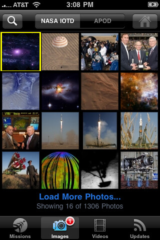
The NASA App collects, customizes and delivers an extensive selection of dynamically updated information, images and videos from various online NASA sources. Users can access NASA countdown clocks, the NASA Image of the Day, Astronomy Image of the Day, online videos, NASA’s many Twitter feeds and other information in a convenient mobile package. It delivers NASA content in a clear and intuitive way by making full use of the iPhone and iPod touch features, including the Multi-Touch user interface. The New Media Team at NASA’s Ames Research Center at Moffett Field, Calif., developed the application.
The NASA App also allows users to track the current positions of the International Space Station and other spacecraft currently orbiting Earth in three views: a map with borders and labels, visible satellite imagery, or satellite overlaid with country borders and labels.
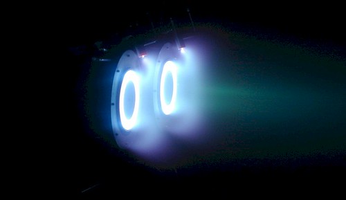
The Air Force Office of Scientific Research is funding Professor Alec D. Gallimore’s research because particle electric propulsion, with its half-inch thruster, increases velocity by several hundred or thousand miles an hour and is expected to have a dramatic impact on nanosatellites and larger spacecraft. These electric fields help to create thrust when the particles are charged, accelerated and propelled into space.
"Particles used in this technology are initially 10 to 50 nanometers in size (approximately a thousand times smaller than a human hair in diameter), and we scale them up to between one and ten microns (1/20th to about half the size of a human hair) because at that size, we can see and use them for advanced propulsion research," said Gallimore.
Even with the modifications there are still challenges in doing NanoFET research.
"There are material science aspects of designing the right materials that can withstand high voltages and close proximity to each other," Gallimore said. "There’s also a challenge of making certain that all materials are in a form that fits on a satellite that’s not much larger than a baseball." Currently the materials are more functional than form-fitting.
"We’re hoping that we can actually resolve a lot of these issues in the next three to four years," said Gallimore. In the meantime, the researchers have tested the nanoparticle, electric-based propulsion in air and in a vacuum chamber on an aircraft that replicates conditions of limited gravity. "It has the potential to be a revolutionary propulsion concept, especially regarding nanosatellites and larger satellites, but there’s also a possibility of applying the technology to non-space vehicle applications as well," he said. AFOSR Program Manager, Dr. Mitat Birkan who oversees the research, agrees. "Electrostatic acceleration of charged nanoparticles has many potential applications besides space propulsion, including manufacturing and biomedical technologies."
This scientific presentation is worth reading, if you’re into that kind of stuff, concluding…
The advantages offered by nanoFET’s potential for high efficiencies, lower thruster specific mass, and longer operational lifetimes are both mission enhancing and enabling.
Very cool rocket science, but still a few years off.
There’s nothing wrong with a good old photo album. Except that it’s dusty, prone to wear and tear and stuck in the past. So we built a digital memory wall that plays a live stream of photos, past and present, across multiple LCD monitors, right before your eyes. In this memory wall, each monitor displays a separate feed, which is networked via FiOS to other family members. So you can set up friends and relatives to add to your wall instantly, with their latest pics.
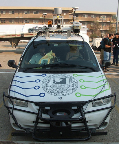
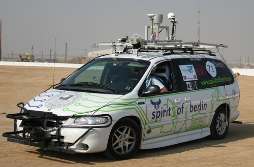
The team developed its iDriver app to manage the highly modified "Spirit of Berlin" autonomous vehicle using WiFi and the smartphone’s controls. The unit’s accelerometer controls steering, accomplished at hand by turning the device, while screen buttons control braking and acceleration. The system also sends a live video stream of the road ahead to the iPhone screen.
The van can also drive itself, by way of technologies developed for the 2007 DARPA Urban Grand Challenge autonomous vehicle race (the van was their entry). Packed inside are a stack of IBM Blade servers, video cameras, 3D laser sensors and GPS for positioning, as well as the drive-by-wire system that enables the iDriver app’s functionality. In one experiment, a team member reportedly sat on the roof rack and steered the vehicle from above.
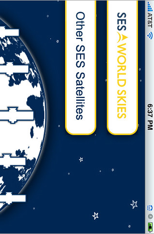
Want to find out a particular satellite’s C-band coverage? There’s an app for that.
Commercial satellite operator SES World Skies published an iPhone app last month. Who knew? No "press release" or splashy introduction on their Web site. So while I was at the SATCON Expo show in New York yesterday, and bada-bing: SES is showing an app in their booth.
OK, let me check it out…
The app is called "SES World Skies" and apparently is the first of its kind. No other "satellite coverage" app exists, so they got that going for them.
First of all, it uses 30 MB and only works in the horizontal position. Google Earth is 8.9 MB. Well, that’s not good. The description is the company’s standard boilerplate:
SES WORLD SKIES is the new global division of SES, created through the combination of the former SES NEW SKIES and SES AMERICOM. The company operates a fleet of 25 satellites – part of the 40 spacecraft of the SES group – delivering services as diverse as television distribution and broadcast, internet access, data transmission and business and government communications to customers worldwide. SES WORLD SKIES currently has six additional satellites under construction. The company’s unique customer-focused approach allows it to offer the best satellite solution for a host of business and government requirements, with a view toward helping customers meet their short-term challenges and realize their longer-term goals. SES WORLD SKIES comprises a world-class team of customer care and technical professionals located in Princeton (NJ), The Hague, Washington D.C., Singapore, Beijing, London, Sao Paulo, Mexico City, Sydney, Accra and Johannesburg. Visit www.ses.com for more information.
WTF? This is enough to get me to download? OK, so it’s free. How do I use it? Nevermind, just start tapping. I did eventually find the instructions page (misspelled, too).
It shows basic, general coverage of each satellite, and lists the general specifications. Does it take advantage of the iPhone’s GPS? No. Can you type in your location and see what satellites are available? No. Can you contact a local sales office for a particular satellite? No. Can you check whether inventory is available for a 4-hour sporting event? No.
SES would have been better off collaborating with DishPointer and building a really good app that promotes their business in general and adds value to the customer experience in particular. In fact, you should check out DishPointer’s app. It rocks. Check out the Augmented Reality Pro version — a steal at $20. Here’s a demo video…
The SES app, unfortunately, won’t be found on many "best iPhone apps" lists any time soon.
Since we like our original ringtone, we naturally take notice whenever we come across other distinct ringtones. The G20 "riot control" people in Pittsburgh took to using the LRAD (Long-Range Acoustic Device) — a directed acoustic device:
LRAD® (Long Range Acoustic Device™) is a breakthrough hailing and warning, directed acoustic device designed to communicate with authority and exceptionally high intelligibility.
What makes the LRAD product unique is its ability to transmit your message with exceptional voice intelligibility and tonal clarity in a highly directional beam, even with significant ambient noise. The directionality of the LRAD device reduces the risk of exposing nearby personnel or peripheral bystanders to harmful audio levels.
Think it would make a cool ringtone? We do. That’s just what T. Foley of Pittsburgh did via Locally Toned:
The sound made by the Long-Range Acoustic Device (LRAD) or sonic canon fired by police during the G20 protests in Pittsburgh on September 24, 2009. I dropped the audio level a bit, took one “firing” of the device from the original audio Carl Cimini shared with Locally Toned, and looped it together to make this short and piercing tone.
I don’t know about you, but I suspect people around you will prompt you to answer your mobile quickly when it rings.
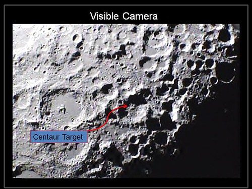
NASA’s Lunar Crater Observation and Sensing Satellite, or LCROSS, created twin impacts on the moon’s surface early Friday in a search for water ice. Scientists will analyze data from the spacecraft’s instruments to assess whether water ice is present.
The satellite traveled 5.6 million miles during an historic 113-day mission that ended in the Cabeus crater, a permanently shadowed region near the moon’s south pole. The spacecraft was launched June 18 as a companion mission to the Lunar Reconnaissance Orbiter from NASA’s Kennedy Space Center in Florida.
"The LCROSS science instruments worked exceedingly well and returned a wealth of data that will greatly improve our understanding of our closest celestial neighbor," said Anthony Colaprete, LCROSS principal investigator and project scientist at NASA’s Ames Research Center in Moffett Field, Calif. "The team is excited to dive into data."
In preparation for impact, LCROSS and its spent Centaur upper stage rocket separated about 54,000 miles above the surface of the moon on Thursday at approximately 6:50 p.m. PDT.
Moving at a speed of more than 1.5 miles per second, the Centaur hit the lunar surface shortly after 4:31 a.m. Oct. 9, creating an impact that instruments aboard LCROSS observed for approximately four minutes. LCROSS then impacted the surface at approximately 4:36 a.m.
"This is a great day for science and exploration," said Doug Cooke, associate administrator for the Exploration Systems Mission Directorate at NASA Headquarters in Washington. "The LCROSS data should prove to be an impressive addition to the tremendous leaps in knowledge about the moon that have been achieved in recent weeks. I want to congratulate the LCROSS team for their tremendous achievement in development of this low cost spacecraft and for their perseverance through a number of difficult technical and operational challenges."
Other observatories reported capturing both impacts. The data will be shared with the LCROSS science team for analysis. The LCROSS team expects it to take several weeks of analysis before it can make a definitive assessment of the presence or absence of water ice.
"I am very proud of the success of this LCROSS mission team," said Daniel Andrews, LCROSS project manager at Ames. "Whenever this team would hit a roadblock, it conceived a clever work-around allowing us to push forward with a successful mission."
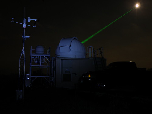
Goddard’s Laser Ranging Facility aiming laser toward LROGoddard’s Laser Ranging Facility directing a laser (green beam) toward the LRO spacecraft in orbit around the moon (white disk). The moon has been deliberately over-exposed to show the laser. Credit: Tom Zagwodzki/Goddard Space Flight Center
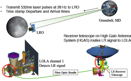
On certain nights, an arresting green line pierces the sky above NASA’s Goddard Space Flight Center in Greenbelt, Md. It’s a laser directed at the moon, visible when the air is humid. No, we’re not repelling an invasion. Instead, we’re tracking our own spacecraft.
28 times per second, engineers at NASA Goddard fire a laser that travels about 250,000 miles to hit the minivan-sized Lunar Reconnaissance Orbiter (LRO) spacecraft moving at nearly 3,600 miles per hour as it orbits the moon.
The first laser ranging effort to track a spacecraft beyond low-Earth orbit on a daily basis produces distance measurements accurate to about four inches (10 centimeters). For comparison, the microwave stations tracking LRO measure its range to a precision of about 65 feet (20 meters).
No, not hurling things into space. We’re talking about hurling, losing your cookies, barfing, blowing chunks — you get the idea.
Here’s an open-source non-lethal weapon designed to make the enemy puke — all for less than $250:
Our first open source Homeland Security non-lethal weapon project – The "THE BEDAZZLER: A Do-it-yourself Handheld LED-Incapacitator".
After attending a conference where the $1 million "sea-sick flashlight" (named "THE DAZZLER") was demonstrated by the US Dept. of Homeland Security, we decided to create our own version. For under $250, you can build your own dazzler and we’ve released the source code, schematics and PCB files to make it easy. A great Arduino project for people who really like blinking LEDs. We also added in a mode selection so you can put it into some pretty color-swirl modes, great for raves and parties!