Archive for the ‘Satellite TV’ Category

PSLV Works — Again!

Wednesday, September 23rd, 2009


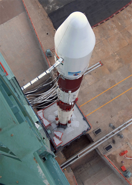
The rocket scientists at ISRO are indeed a happy bunch today:

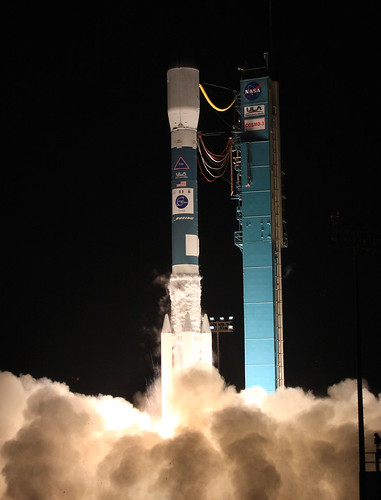
In its sixteenth flight conducted from Satish Dhawan Space Centre (SDSC) SHAR, Sriharikota today (September 23, 2009), ISRO’s Polar Satellite Launch Vehicle, PSLV-C14 successfully launched the 960 kg Indian remote sensing satellite Oceansat-2 and six nano satellites for international customers into a polar Sun Synchronous Orbit (SSO). This was the fifteenth successful flight of PSLV. PSLV-C14

After a 51 hour count down, PSLV-C14 lifted off from the first launch pad at SDSC SHAR, at 11:51 am IST with the ignition of the core first stage. The important flight events included the separation of the first stage, ignition of the second stage, separation of the payload fairing at about 125 km altitude after the vehicle had cleared the dense atmosphere, second stage separation, third stage ignition, third stage separation, fourth stage ignition and fourth stage cut-off.

The 960 kg main payload, Oceansat-2, was the first satellite to be injected into orbit at 1081 seconds after lift-off at an altitude of 728 km. About 45 seconds later, four of the six nano satellites were separated in sequence. The initial signals indicate normal health of the satellites.

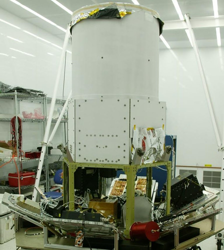
Oceansat-2 is the sixteenth remote sensing satellite of India. The state-of-the-art Oceansat-2 carries three payloads and has the shape of a cuboid with two solar panels projecting from its sides.

The eight band Ocean Colour Monitor (OCM) payload carried by Oceansat-2 images a swath (strip of land or ocean) of 1420 km width with a resolution of 360 metre and works in the Visible and Near Infrared region of the electromagnetic spectrum. The Ku-band Scatterometer with a 1 metre diameter antenna rotating at 20 rpm, works at a frequency of 13.515 GHz. The Scatterometer covers a swath of 1400 km and operates continuously. ROSA is a GPS Receiver for atmospheric sounding by radio occultation built by Italian Space Agency (ASI).

Soon after separation from PSLV fourth stage, the two solar panels of OCEANSAT-2 were automatically deployed. The satellite’s health is continuously monitored from the ISRO Telemetry, Tracking and Command Networks (ISTRAC) Spacecraft Control Centre at Bangalore with the help of a network of ground stations at Bangalore, Lucknow, Mauritius, Biak in Indonesia and Svalbard and Tromso in Norway as well as a station in Troll, Antarctica.

Here’s the video report, via Star News:


Greece Fire

Tuesday, August 25th, 2009


 Nice satellite imagery via the University of Maryland’s FIRMS (Fire Information for Resource Management System) and NASA’s MODIS Rapid Response System.  MODIS: Moderate Resolution Imaging Spectroradiometer.

The fires near Athens were brought under control recently. Here’s a video report:


And here’s more on MODIS, the rocket science behind the imagery…


ICESAT, Baby!

Wednesday, July 8th, 2009


Does Vanila Ice care about "global warming?" He probably does. As do many others, adding drama to real science.

NASA’s been at it, too, but only now are we talking about a dramatic change in the Arctic ice. The spacecraft, ICESat, uses laser light to measure the Earth’s ice:

ICESat is designed to observe seasonal and interannual variations in surface elevation that are caused by variations in precipitation (snowfall) and surface melting. These data will be used in energy-balance models and to test the results of atmospheric circulation models used to predict climate-induced changes. ICESat should detect changes in mass balance expected for each 1 degree change in polar temperatures (depends on sensitivity estimate). ICESat measurements are essential for making reliable assessments of whether future changes in ice volume will add to the sea level rise, which is already occurring due to the warming and thermal expansion of the oceans and worldwide melting of small glaciers, or whether the ice sheets might grow and absorb a significant part of the predicted sea level rise.

Now comes the drama, from the Great White North, via Canada.com:

Arctic sea ice thinned dramatically between the winters of 2004 and 2008, with thin seasonal ice replacing thick older ice as the dominant type for the first time on record, data from a NASA Earth-orbiting spacecraft has revealed.

Calling it the most comprehensive survey to date, scientists from NASA and the University of Washington say the information provides "further evidence for the rapid, ongoing transformation of the Arctic’s ice cover."

"The thickness and volume of the ice cover is continuing to decline, making the ice more vulnerable to continued shrinkage," NASA research team leader Ron Kwok said. "Our data will help scientists better understand how fast the volume of Arctic ice is decreasing and how soon we might see a nearly ice-free Arctic in the summer."

Using measurements from NASA’s Ice, Cloud and Land elevation satellite — ICESat — scientists found that overall Arctic sea ice thinned nearly 18 centimetres a year for a total of 72 centimetres over four years.

The data also shows that the total area covered by the thicker, older "multi-year" ice that has survived one or more summers shrank by 42 per cent.

Kwok said ICESat allows scientists to monitor ice thickness and volume changes over the entire Arctic Ocean for the first time.

 Check out the video…


Ask The Satellites

Thursday, June 4th, 2009

Here’s the latest infrared image of the Atlantic Ocean region that includes the path of AF447:


France is asking the U.S. DoD for help in finding clues:

France has also asked Washington to scan data from its spy satellites and electronic intelligence facilities for clues.

US Air Force Defense Support Program (DSP) missile warning satellite data, collected early 1 June over the central Atlantic, will be examined to see if a breakup or impact of a crashing aircraft was captured.

Experts say two or three Northrop Grumman DSPs constantly scan that region of the Earth with powerful infrared telescopes. The satellites, based in geosynchronous orbit at nearly 23,000 miles in altitude, are designed to detect the heat from the launch of land or sea based ballistic missiles.

Each satellite carries a 6,000 element mercury-cadmium-telluride detector which is capable of discriminating not only missile launches but other thermal phenomenon such as lightning, meteorites and aircraft that are flying on afterburner or on fire.

Other systems being tapped for data will include two new Space Based Infrared System (SBIRS) sensors onboard two National Reconnaissance Office spacecraft in highly elliptical orbits. Unlike DSPs, the new SBIRS satellites are yet to provide continual coverage of all areas of Earth. It remains to be seen if a SBIRS system was pointing in the area of the crash.

SIGINT (signal intelligence) "eavesdropping" spacecraft data will also be examined for unusual static or other transmissions which may have been picked up coming from the stricken aircraft.

Penguin Surveillence

Wednesday, June 3rd, 2009


Holy Satellite, Batman! It’s the Penguin!

No, not really, citizens. I wish this story was as entertaining as the Batman TV series from the 1960s.  The story here handed the British press a fantastic story. Note the great lead in the piece from The Times:

 It may be the king of the species but the personal hygiene of emperor penguins is far from regal. Vast expanses of penguin droppings that are visible from space are helping scientists pinpoint the whereabouts of penguin colonies in Antarctica.

Using satellite images, British scientists were able to locate penguin communities by the reddish brown patches, known as guano, left by the birds on the sea ice. They say the results of the study will help them to monitor the emperor penguin population in the face of climate change.

Emperors, which have white bellies, black backs and distinctive golden ear patches, are the largest members of the penguin family. They can grow to 122cm (4ft) tall and weigh around 30kg (5st) as adults.

“The ice gets pretty dirty and it’s the guano stains that we can see,” said Peter Fretwell of the British Antarctic Survey (BAS), who led the study.


The video clip from the Associated Press was just as tasteful, and informative…


Other editors had a field day with this one.

Polar penguin’s poo pinpointed in space pics (Tech Herald)

Scientists hit pay dirt with penguin droppings (Sydney Morning Herald)

Satellite snoops on penguin poop to track colonies (AFP)

Penguin poo patches seen from space (The Press Association)


India’s Spy Sat Launch

Wednesday, April 22nd, 2009

Nice PSLV launch the other day. The report, via PTI:

Giving the much needed fillip to its defence surveillance capabilities, India today successfully placed into orbit an Israeli-built all-weather spy satellite but not before some "anxious moments" prior to the launch caused by a technical glitch which had threatened to stall the mission.

The 300 kg RISAT-2, which will also help tackle infiltration and terror activities, was shot into space by ISRO’s workhorse PSLV-C12 rocket 19 minutes after it blasted off from the spaceport here as scheduled at 6.45 AM, making India the fifth country having such a satellite.

But the launch was preceded by "anxious moments" during the 48-hour countdown for the ISRO team after an umbilical connector from PSLV-C12’s top got detached from the launch vehicle and about half-a-dozen others were "thrown out".

The last minute snag was overcome with the ISRO team managing the crisis making up the six hours of countdown time and setting everything right.

"With that condition, we could not not have gone on with the launch," ISRO Chairman G Madhavan Nair later said. "The final moments of the launch were more thrilling than a cricket match as we hit a few boundaries and bowled some googlies." The PSLV-C12, on its 15th mission, also launched RISAT-2’s co-passenger micro-educational satellite ANUSAT into orbit. A jubilant Nair described the RISAT-2 as a "new year gift" which would be an "asset" to the country as it worked in a mircowave band that would enable it to see through clouds and during night. 

Here’s the video report:


Launching From MARS

Tuesday, April 14th, 2009


That’s right, MARS: the Mid-Atlantic Regional Spaceport, located on Wallops Island in Virginia. The Wallops Research Range is America’s oldest continuously-operating rocket launch range. It’s been around for more than 60 years and has supported more than 16,000 flight events.

On 5 May 2009, it’s leading the launch of a Minotaur 1 rocket carrying three payloads. The summary, via delmarvanow.com:

The spacecraft — consisting of an ATK Space Systems satellite bus and Tactical Satellite-3, which carries a trio of experiments — will be taken into space by an Orbital Sciences Corp. Minotaur I rocket.

The four-stage rocket includes two taken from retired Minuteman intercontinental ballistic missiles and two from Orbital’s Pegasus booster.

"Obviously, the project has much to do in these next few weeks leading up to lift off, but we now have a firm end date to get on orbit and begin the fun experiment phase," TacSat-3’s program manager Thomas Cooley said about problems encountered earlier in the project with some of the spacecraft’s components.

The main experiment aboard the satellite, ARTEMIS HSI, was developed by Raytheon Co. It is designed to quickly supply military commanders in the war theater with target detection and identification information, along with information about battlefield preparation and combat damage.

A second payload on TacSat-3 is the Office of Naval Research’s Satellite Communications Package, which will collect data from sea-based buoys and transmit it back to a ground station.

A third experiment, the Air Force Research Laboratory’s Space Avionics Experiment, is described in a prepared release from the Air Force as "plug-and-play avionics to advance the technology of rapid spacecraft integration and help enable the responsive space vision."

All three payloads have been tested at Kirtland Air Force Base in New Mexico and final checks of the flight software have been completed in preparation for the May launch.

"Our program team never gave up, and establishment of the launch date serves as a testimony to their dedication, determination and duty to making TacSat-3’s mission a success,” Cooley said.

The spacecraft is now at MARS, where it will be joined with the launch vehicle.


Expect the launch to be webcast here.

Go for GOCE

Tuesday, March 17th, 2009

The ESA’s gravity spacecraft couldn’t get off the ground yesterday, but it’s a "go" for today:

Attempt One Issue:

“The doors on the launch service tower did not open,” noted ESA. ”Due to this anomaly, the tower was held in position and did not move back as required for a launch.”

I suspect some people around the St. Patrick’s Day parade in New York will be dealing with gravity issues today. More about GOCE:

Clarified by Isaac Newton in the 17th century, gravity is a fundamental force of nature. Everything that has mass is pulled by gravity. As Earth is not a perfect sphere and its interior has layers and zones of different density, gravity varies around the globe.
 
Gravity and its variation in space are fundamental for every dynamic process on Earth’s surface and in its interior. Improving our knowledge of how gravity affects the interaction between these processes has practical benefits in today’s changing world.

An accurate gravity map – the geoid – is also crucial for geodesy applications and for defining a sea surface height reference model with which to accurately survey ocean circulation patterns and sea-level changes.


Bella Lancio di Razzi

Monday, October 27th, 2008


Yes, the Delta rocket is still working. This time for the Italian COSMO/SKYMED-3 and the United Launch Alliance:

A United Launch Alliance Delta II rocket, on behalf of Boeing Launch Services, successfully launched the third Italian-built Constellation of Small Satellites for Mediterranean Basin Observation or COSMO-SkyMed 3 satellite at 7:28 p.m., October 24. ULA successfully launched the first two Cosmo satellites on Delta II vehicles June 7, 2007 and Dec. 8, 2007.

"ULA is pleased to have successfully launched the third of four critical Earth observation systems in this series for Boeing and Thales Alenia Space," said Jim Sponnick, ULA vice president, Delta Product Line. "With this 43rd successful commercial launch, the Delta II system continues its record of mission success, which is unparalleled in the U.S. space industry. This achievement is due to the hard work of our professional engineers and technicians along with the tremendous support we receive from our government, industry, and supplier mission partners. We look forward to many more Delta II launches in the years ahead."

Blasting off from Space Launch Complex 2, it marked the fifth successful Delta II vehicle launch procured by The Boeing Company through its commercial launch business. The ULA Delta II 7420-10 configuration vehicle featured an ULA first stage booster powered by a Pratt & Whitney Rocketdyne RS-27A main engine and four Alliant Techsystems (ATK) strap-on solid rocket boosters. An Aerojet AJ10-118K engine powered the second stage. The payload was encased by a 10-foot-diameter composite payload fairing.

ULA began processing the Delta II launch vehicle in Decatur, Ala., nearly two years ago. In February, the 1st stage arrived from Decatur followed by the 2nd stage in August. The vehicle was erected on its stand at the pad Sept. 16, with solid rocket booster installation completed Sept. 19. Hundreds of ULA technicians, engineers, and management worked to prepare the vehicle for the COSMO-3 mission.

Developed by Thales Alenia Space, Italia for the Italian Space Agency and the Italian Ministry of Defense, COSMO-3 is the third of the four COSMO-SkyMed satellites. Each satellite is equipped with a high-resolution Synthetic Aperture Radar operating in X-band and is one of a constellation of four radar satellites. The overall objective of the program is global Earth observation and relevant data responding to the needs of the military and scientific community, as well as to the public demand for environmental control.

Here’s a nice video:


And here’s one shot on-site, from a distance:


Elliptical C-band Uplink Antennas

Friday, October 24th, 2008

Via Doug Lung’s RF Report:

In some cases, it isn’t possible to install an uplink dish that meets the FCC off-axis antenna pattern envelope. In the past, the FCC allowed operation of uplinks with non-compliant antennas upon a showing by the licensee that the effective isotropic radiated power (EIRP) would be reduced enough to keep the energy in side lobes below the level that would have existed using an uplink with a compliant dish at maximum power. This required a detailed engineering showing that often slowed FCC processing.

In the Eighth Report and Order and Order on Reconsideration (FCC 08-246), the FCC adopted an off-axis EIRP envelope approach as one method for applicants to apply for fixed satellite service (FSS) Earth stations using small antennas operating on conventional C and Ku-band frequencies.

It states, "This off-axis EIRP approach gives earth station applicants the flexibility to reduce their power levels to compensate for a small antenna diameter. Thus, using these envelopes as criteria for licensing should enable us to license more earth station applications routinely, expediting the provision of satellite services to consumers and enhancing the types of services available, without increasing the likelihood of harmful interference to adjacent satellite operators or to terrestrial wireless operators."

The Order adopts rules that facilitate the use of elliptical C-band uplink antennas. While the new rules do not specifically state that the major axis of the elliptical antenna be aligned with the geo-stationary orbit plane, the Order notes that "that starting the off-axis EIRP envelope at 1.5 degrees off-axis within the GSO orbital plane, and at 3.0 degrees outside that plane, has the same effect as requiring elliptical antennas to be aligned with the GSO plane in most cases."

The Satellite Industry Association (SIA) claimed that it is not possible to develop an off-axis EIRP envelope for analog video signals because the power density of such signals fluctuates. SES Americom opposed new analog regulations because the current rules are working well. The FCC decided to retain the current regulatory framework for analog services at this time. It dropped plans for eliminating analog video transmission over satellite entirely, noting, "The record in this proceeding has shown convincingly that requiring the transition from analog to digital video transmissions proposed in the Third Further Notice would be unreasonably expensive and burdensome."