Archive for the ‘Satellite TV’ Category

Bread & Satellites

Wednesday, October 15th, 2008

If you’ve spent some time in Ann Arbor, Michigan, you may have come across a Zingerman’s — a host of specialty foods delis, restaurants and related businesses. They’re known for having one of the best mail-order breads in the U.S.


The University of Michigan’s Student Space Systems Fabrication Laboratory is working on a micro-satellite about the size of a loaf of bread. The story, via Space Daily, gives us more:

U.S. scientists say they are developing a satellite about the size of a loaf of bread that will be deployed to study space weather.

The National Science Foundation-funded project called Radio Explorer, or RAX, is being led by the University of Michigan and the SRI International Corp., a California independent research and technology development organization.

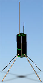
The satellite, called CubeSat, is to be the first free-flying spacecraft, and will be built, in part, by members of the university’s Student Space Systems Fabrication Laboratory.

CubeSats are approximately 4-inch cube-shaped devices that launch from inside a P-Pod — a special rocket attachment developed by California Polytechnic State University and Stanford University.

The RAX satellite will essentially be made of three CubeSats and will measure the energy flow in the Earth’s ionosphere, where solar radiation turns regular atoms into charged particles.

"This project will help us better understand space weather processes, how the Earth and sun interact and how this weather produces noise in space communication signals — noise that translates to lower quality telecommunications capabilities and error in GPS signals," said Assistant Professor James Cutler, a co-principal investigator with physicist Hasan Bahcivan of SRI.

The grants from the National Science Foundation, who use a less-imaginative "half gallon carton of milk" metaphor, hopes to develop more student interest in space, too:

The National Science Foundation (NSF) has awarded a grant to SRI International, an independent non-profit research and development organization based in Menlo Park, Calif., to carry out the first space weather CubeSat mission.

CubeSats are tiny satellites with dimensions of 10��10��10 centimeters, weighing about 1 kilogram, and typically using commercial off-the-shelf electronics components.

Developed through joint efforts, California Polytechnic State University and Stanford University introduced CubeSats to academia as a way for universities throughout the world to enter the realm of space science and exploration.

According to atmospheric scientists, CubeSats have the potential to be excellent platforms for technology development and small science missions, and promote student involvement in design, fabrication and flight missions.

"One of the goals is to help train future space scientists and aerospace engineers," said Therese Moretto Jorgensen, program director in NSF’s Division of Atmospheric Sciences. "CubeSats will also help answer questions in space weather such as the cause of disturbances in the ionosphere, and the rise and decay of the Earth’s radiation belts during geomagnetic storms."


SRI International’s team will include many, including support from NASA:

“SRI is excited about the NSF contract, and working in collaboration with the University of Michigan,” said Hasan Bahcivan, research physicist at SRI International. “This program provides a cost effective way to support space weather and atmospheric research. It is also well positioned to provide excellent training opportunities for students that hope to become engineers or scientists. We expect 20 to 30 students to take significant roles in the design, development, and science operations of the satellite.”

The project’s mission is designed to remotely explore small-scale ionization structures in the form of plasma turbulence that occurs in response to intense electrical currents in the space environment. The structures can adversely impact communication and navigation signals by perturbing the refractive index along the signal propagation paths. By utilizing signals from powerful transmitters on the ground and receiving the scattered signals in space, researchers are achieving effective and powerful space-based radar to probe these structures, which would be expensive to accomplish via a stand-alone satellite radar. 

"We have a multidisciplinary, cross-departmental team working on the project, that includes several engineers and faculty, and a large number of undergraduate and graduate students," said James Cutler, an assistant professor in the Aerospace Engineering Department at the University of Michigan. "My research laboratory will be partnering with several space-related classes and the Student Space Systems Fabrication Laboratory (S3FL) to build and fly RAX."   

The first launch opportunity for the NSF satellite program will be with the Department of Defense Space Test Program, and is scheduled for December 2009 aboard a Minotaur-4 launch vehicle out of Kodiak, Alaska. Commissioning and launch support for the mission will be provided by NASA Goddard Space Flight Center Wallops Flight Facility.

This is the kind of government support we need to develop the future of rocket science.


Looks Like Kutztown

Friday, October 10th, 2008


Copyright © 2008 GeoEye


GeoEye-1’s first image released of Kutztown University in Pennsylvania:

GeoEye, Inc. (NASDAQ: GEOY), a premier provider of satellite, aerial and geospatial information, released today the first, color half-meter ground resolution image taken from its GeoEye-1 satellite. The satellite has been undergoing calibration and check-out since it was launched on Sept. 6 from Vandenberg Air Force Base in Calif. The Company will begin selling GeoEye-1 imagery products later this fall.

The Kutztown University image shows the campus, which includes academic buildings, parking lots, roads, athletic fields and the track-and-field facility. The image was collected at 12:00 p.m. EDT on Oct. 7, 2008 while GeoEye-1 was moving north to south in a 423-mile-high (681 km) orbit over the eastern seaboard of the U.S. at a speed of four-and-one-half miles per second. GeoEye-1 was built by General Dynamics Advanced Information Systems in Gilbert, Ariz. The imaging system was built by ITT in Rochester, NY.


Smile For The Satellite

Thursday, October 2nd, 2008

Chelyabinsk is one happy town. They’ve come a long way from being "the most contaminated spot on the planet."

Here’s an interesting story from Slashdot:

Citizens of the Russian town Chelyabinsk calculated when the satellite, QuickBird, which takes images for Google Earth and Google Maps, would cross above their city and used people to make a giant smiley face. A rock concert on the main square attracted many people and everyone got a yellow cape. It looks like someone at Google was quicker than usual to put up the new data. Maybe Google likes the idea of an entire town working hard to get its 15 minutes of fame. The article has a screenshot of Google Maps and images taken directly at the event."

They did pretty good:


This isn’t the first time that Google Earth or Google Maps has captured something interesting from space. Longtime readers of Really Rocket Science will recall the Ipod that fell to Earth, which we wrote about way back in March of 2006:


But there’s more to be seen than "Ipods" and smiley faces in the world of Google Earth. GoogleSightSeeing.com — whose tag line is "Why Bother Seeing the World for Real?" has a great series of blog posts on cool sights that you can see right from your computer desk. Be sure to check out this map of global points of interest.

Here’s a clip on Chelyabinsk:


Pentagon’s BASIC Approved

Wednesday, September 17th, 2008

Via the AP:

 The Pentagon has approved plans to buy and launch two commercial-class imagery satellites to complement its classified constellation of spy satellites.

The Pentagon will also increase the amount of imagery purchased from private companies operating similar satellites already in the sky.

The decision last week caps months of wrangling between the Air Force, the National Reconnaissance Office, and the National Intelligence Directors Office and the Office of the Secretary of Defense over which agency would buy the satellites for about $1.7 billion. The satellites are to be launched around 2012. The NRO will head satellite acquisition, according to Pentagon documents obtained by The Associated Press.

But critics of the program say the Pentagon is spending billions to recreate and compete with private companies like GeoEye of Dulles, Va., and DigitalGlobe of Longmont, Colo., which are expected to put four new satellites into orbit by 2013. On its face the decision conflicts with the president’s national security space policy, which directs the government to buy as much commercial imagery as possible to help the companies withstand competition from subsidized foreign satellite companies.

Purchasing the imagery from the companies may also be less expensive. The GeoEye 1 satellite was launched on Sept. 6 for $502 million, including the satellite, launch, insurance and four ground stations, according to company spokesman Mark Brender. It is expected to begin taking 16-inch resolution imagery this weekend.

The Pentagon may decide to turn over operation of the new satellites to the private companies, the internal document notes.

The new satellites will comprise the Broad Area Space-Based Imagery Collection satellite system, or BASIC. They will also have 16-inch resolution. They could be used to spy on enemy troop movements, spot construction at suspected nuclear sites or alert commanders to militant training camps. Their still images would be pieced together with higher resolution secret satellites into one large mosaic.

The new satellite system is meant to bridge what intelligence agencies fear will become a gap caused by the cancellation in September 2005 of a major component of the Future Imagery Architecture system overseen by the National Reconnaissance Office. The primary contractor, The Boeing Co., headquartered in Chicago, ran into technical problems developing the satellite and spent nearly $10 billion, blowing its budget by $3 billion to $5 billion before the Pentagon pulled the plug, according to industry experts and government reports.

A single satellite can visit one spot on Earth once or twice every day. BASIC’s additional satellites will allow multiple passes over the same sites, alerting U.S. government users to potential trouble, humanitarian crises or natural disasters such as floods.


Maybe now we’ll be able to see license plates from space.


Google Maps is about to get even better

Monday, September 8th, 2008


The GeoEye-1 satellite – the world’s highest resolution, commercial Earth-imaging satellite – was launched on Saturday.

You’ll soon be able to check out the satellite’s images for yourself:

ars technica In return for undisclosed terms, Google got two considerations: its logo on the side of the launch vehicle, and exclusive use of the mapping images that the satellite produces.

The satellite maker, General Dynamics Advanced Information Systems, says the GeoEye-1 cost $500 Million to build and launch and its imaging services could be sold for anything from environmental mapping to agriculture and defense. Funding for the project came from commercial satellite company GeoEye and the Defense Department’s National Geospacial-Intelligence Agency


DIY Friday: HDTV Antenna

Friday, August 15th, 2008

Question: What can you make with 2 forks, an old lamp, and a shoelace?

Answer: A sweet HDTV Antenna!

One of our most popular DIY Friday projects was this post on how to build your own HDTV antenna.

And, this week we’re bringin’ it back with some new tricks.

The $10 lamp version above is a great option. Or you can try the Gray-Hoverman Antenna, which has gotten some great reviews:

"Boy, this antenna is hot. I finally got it pointed right. After I did a search for channels, I got 23 digital channels, and this is from about 30-40 miles, over mountains…This antenna is a vast, and I mean REALLY VAST improvement over anything I have used." – DogT


Predicting Space Weather

Monday, July 21st, 2008

On reading that title, you might be asking yourself “why in the world would I need to predict space weather?” Well, I’ll tell you. Space weather – the range of high-energy radiation, such as X-rays and gamma rays, that constantly bombard the Earth’s atmosphere – affects the performance of some of your favorite gadgets, like GPS and satellite TV.

With this camera, scientists can predict changes is space weather, allowing for communications companies to compensate for electromagnetic interruptions to their signals. Never again will your Planet of the Apes marathon be spoiled by a bad signal. Oh, and it’ll help the military predict and plan for interruptions in their communications too.

The project – the Global-Scale Observations of the Limb and Disk – is known by a catchy acronym: GOLD.

The GOLD Camera will fly on an SES AMERICOM satellite. Physicist Richard Eastes, who leads the GOLD project, says this is the first time that a NASA instrument has flown on a commercial communications satellite.

This is the second “hosted” payload for an AMERICOM spacecraft just this month. The other was for the Air Force’s CHIRP (Commercially Hosted Infrared Payload).

Russian Hide-N-Seek

Wednesday, July 16th, 2008


As Mark Twain said, "Always tell the truth. That way, you don’t have to remember what you said." The Russian Defence Ministry’s Information and Public Relations Directorate ought to make a note of it.

Back in April, Red Orbit reported they denied a major satellite malfunction:

"In connection with reports published in some mass media alleging that the Kosmos-2421 satellite has disintegrated, we would like to report that its planned flight programme has been fulfilled. After switching off its on-board equipment, the satellite was taken out of service in accordance with the established procedure", reads the directorate’s report received by Interfax-AVN today.

According to the Defence Ministry, "the Kosmos-2421 satellite remains in its orbit, the parameters of which correspond to the predicted ones, and is under steady observation by means of the national system of space control".

The ministry added that there are three more space objects in orbits close to Kosmos-2421. "One of them is a stage vehicle of a carrier rocket, and the other two – fragments of a launch [vehicle]", the report says. [Passage omitted on "a NASA website" report on the alleged disintegration of the satellite; background]

Originally published by Interfax-AVN military news agency website, Moscow, in Russian 1431 15 Apr 08.

Well, according to NASA’s Orbital Debris Quarterly News, that’s not entirely true:

Late in the first quarter of 2008, the U.S. Space Surveillance Network (SSN) detected a significant fragmentation of Cosmos 2421 (International Designator 2006-026A, U.S. Satellite Number 29247), which produced approximately 300 detectable debris (see ODQN, Vol. 12, Issue 2). Two more fragmentation events of the same spacecraft during April-June added another 200 or more large debris (greater than 5 cm) to the near-Earth space environment, once again raising questions about the peculiar nature of this satellite class.


You can count on our friends at U.S. Strategic Command’s Space Surveillance Network to keep an eye on them.


First Storm of the Season

Monday, July 7th, 2008


It’s officially hurricane season and Bertha is gearing up to be the year’s first storm.

Whether you might find yourself in the eye of the storm or you’re just intrigued by extreme weather, you’re sure to appreciate the fun tools that the National Weather Service puts out for the public. This one lets you track the storm’s movements. And this one shows wind speeds.

How do they get all the data for these cool images? Why satellites, of course. And the NOAA has a full arsenal. But how does all the information coming from those satellites turn into something we can understand, like this animation of the season’s first hurricane?

With Giovanni it’s simple. And no, that isn’t the name of an Italian tropical storm guru…

Giovanni is actually an acronym for the GES-DISC (Goddard Earth Sciences Data and Information Services Center) Interactive Online Visualization ANd aNalysis Infrastructure.

In other words, it’s a web-based application developed by NASA that is available to anyone with a computer and a bit of spare time. But beware, for those of us who’ve lost hours tooling around on Google Earth, this can become a bit addictive…

Shake, Shake, Shake

Wednesday, June 11th, 2008

Mobile Satellite Ventures is proposing a system to help predict earthquakes in the U.S. Naturally, it’s a satellite-based system:

Mobile Satellite Ventures (MSV) today announced that it has joined with the Central United States Earthquake Consortium (CUSEC) to form a new satellite mutual aid radio talkgroup (SMART) dedicated to the preparation for and response to earthquakes throughout the central United States.

CUSEC is a partnership of the federal government and eight states most affected by earthquakes in the central U.S. including Alabama, Arkansas, Illinois, Indiana, Kentucky, Mississippi, Missouri and Tennessee. The organization serves as the coordinating hub for the multi-state region and as a partnership of organizations to mediate disasters and save lives caused by earthquakes in the central U.S.

MSV is expected to shake things up with their new satellite, MSV-1, expected to launch in 2009 and based on Boeing’s GeoMobile platform (like Thuraya, but bigger). Wait a minute: where’s California? They have their own earthquake people. But central U.S.? There was an earthquake measuring 5.2 on the Richter Scale in the Wabash Valley on 18 April 2008, via The Southern Illinoisan:

An earthquake centered in southern Illinois rocked people awake across the Midwest early Friday, surprising residents unaccustomed to such seismic activity.

The quake just before 4:37 a.m. was centered 6 miles from West Salem, Ill., and 66 miles west of Evansville, Ind.

Initially pegged as a 5.4 earthquake, the U.S. Geological Survey revised its estimate to give it a value of 5.2.

West Salem is in Edwards County, and dispatcher Lucas Griswold says the sheriff’s department received several calls about the earthquake but only reports of minor damage and no injuries.

“Oh, yeah, I felt it. It was interesting,” Griswold said. “A lot of shaking.”

Meanwhile, on the other side of the world, Australian Broadcasting is reporting a new satellite system for predicting earthquakes using ionospheric dimpling:

The theory suggests that much of earth’s rock has soaked up water, which has later been exposed to extreme heat and pressure inside the earth. Those conditions break apart the water and create the electrically conductive crystals that exist inside most rocks, as well as byproducts such as oxygen.

As pressure builds before an earthquake, the oxygen molecules inside the rocks undergo chemical reactions, creating a positive electrical charge that radiates out toward the earth’s surface.

"It’s similar to how an electrical charge radiates through a battery," says Freund.

The charge creates a subtle fluorescent, infrared glow and a magnetic field one to two weeks before a major earthquake.

That light shines into space, the theory goes, where satellites can register the change.

Low-resolution thermal cameras aboard the proposed satellites would scan the earth to detect earthquake precursors, says Eves.

The positively charged magnet creates a dimple, up to 20 kilometres deep, in the earth’s atmosphere by attracting negatively charged ions from as far away as 600 kilometres above the surface of the Earth.

To detect this ionospheric dimpling, the satellites would monitor the existing Global Positioning Satellite System with three small GPS antennas on its side. As each GPS satellite comes up over the horizon, its signal would pass through the ionosphere. Any dimpling would change that signal.

The theory is not without skeptics.

"As far as I know, there is no published research to suggest that this will work," says Dr Mike Blanpied, who is with the United States Geologic Survey’s Earthquake Hazards Program.

This early-warning system was reported by the Wall Street Journal last month:

Early in May, NASA earth scientists monitoring infrared images of the earth noticed unusual patterns in southwestern China. One sent an email to colleagues, noting: Something is happening in Sichuan province.

For Friedemann Freund, a chemist-turned-NASA geophysics researcher, it was more support for his simple, though hotly contested theory: Earthquakes are the culmination of drawn-out physical processes that can be tracked sometimes more than a week ahead of the main event.
 
The main idea: Rocks put under enough pressure — for example, when tectonic plates shift — turn into batteries. The resulting electrical currents can travel miles into the earth, Dr. Freund says. The infrared images observed by NASA, for example, were concentrated several hundred miles from the epicenter of the roughly 8.0 magnitude earthquake that struck on May 12, killing at least 34,000 people.

Dr. Freund describes his discovery as simple, made at 2 p.m. on a Friday afternoon in early 2005 just before he and his graduate students finished packing up a temporary laboratory they had been using. For experiment No. 167, one for the road, they decided to use a copper contact to test whether a squeezed rock emitted a current. It did.

"This is something that should have been discovered 50 years ago," he said.

Certainly, people have tried. For more than a century, researchers have debated the pursuit of the "holy grail" of earthquake prediction. There is still no widespread support for linking electromagnetic signals, infrared emissions or atmospheric changes to an approaching quake.

Satellites are used to communicate seismic data, and transmitting videos, of course. The prospect of being able to predict such events many days in advance seems like a real possibility. Count on the Smithsonian to present it, probably based on a published piece by Dr. Ouzounov of George Mason University.