Archive for the ‘Observation’ Category

Bharti Time for Gilat and IBM

Tuesday, January 22nd, 2008


After a rough 2007 — in which they lost $335,000 on nearly $40 million in revenues,  compared to a 2006 profit of just over $250,000 — Israel’s Gilat Satellite Networks Ltd. is entering 2008 with some good news:

Israel’s Gilat Satellite Networks Ltd. announced Monday that it will supply India’s Bharti Airtel with a broadband satellite network comprising more than 13,000 small two-way ground stations.

The new network, using Gilat’s SkyEdge technology, will be used by Bharti Airtel to offer information and communication services to the local citizens of India’s Gujarat State.

The agreement "will enable remote citizens in the state of Gujarat to benefit from information and e-governance services," Erez Antebi, CEO of Gilat Network Systems, said in a statement.

Gilat offers VSATs or very small aperture terminal, a two-way satellite ground station with a dish antenna, in India.

SkyEdge is a satellite communications system that delivers high-quality voice, broadband data and video services over a powerful unified system. 

No word yet on the value of the contract, but it’s probably just a taste of the satellite broadband opportunities that are rapidly emerging in India. Compare it, for example, to the deal Bharti signed with IBM, which includes direct-to-home satellite services and IPTV:

In a bid to boost its triple play platform, Bharti Airtel has awarded a $150-million contract to IBM to provide IT solutions and services to support broadcasting services such as DTH and IPTV.

Bharti had already outsourced its IT requirement for the telecom business and the new deal is aimed at providing a one-stop experience spanning mobile, PC and television. 

A direct-to-home satellite TV service in India is, of course, the satcom motherloade. People have been trying to launch that kind of service for years. Back in 1999, News Corp’s ISkyB attempted it in partnership with Hughes; Star TV India was another service from News Corp, which is now a collection of premium content for India.  


AT&T’s Satellite Radio System

Wednesday, January 16th, 2008

What happens to all that extra capacity if and once Sirius and XM merge? Mobile TV, perhaps? Judging from the initial success of vestigal sideband tests, they’d need something different.

I seem to recall AT&T owning Wireless Communications Services (WCS) spectrum that was in two 15MHz blocks at 2.3GHz with satellite radio (XM and Sirius) in and around those blocks. There was concern that once new WCS came around, there would be interference with satellite radio services — especially C and D channels of this WCS spectrum. But if you grab some of the spectrum that become available after a merger, then one could essentially coordinate the frequencies nicely.

So what do we see AT&T file with the patent office last week? Two applications for a satellite radio system with feedback. Nice catch by Satellite Radio TechWorld:

Through various mergers, AT&T has acquired enough spectrum that could possibly make satellite radio practical. Plus, technology has developed that would make spot beams more practical. There are only a few players left. It wouldn’t take but a few players to come together for nationwide service. Most of the WCS license holders are planning to use WiMax, but it is not practical under the current regulations. They are trying to change the rules in order to make it practical and the same time the FCC is trying to determine the final rules for satellite radio repeaters. If rules are not adapted that would make WiMax practical, then satellite radio might be the next best practical use of the spectrum.

And the timing? Ingenious:

It is interesting to note that this application was filed after XM and Sirius announced the merger (September 24, 2007). Applications can be kept away from the public for up to 18 months, if we recall correctly. This was less than four months ago. They wanted this to be public. However, this is not new. It is based on an application filed in September 2003 and recently became patent on September 25, 2007. No doubt it is enough to give XM and Sirius pause for consideration. 

Here are the two applications (in PDF):

Digital Radio Feedback Apparatuses, System, and Methods

Digital Radio Feedback Systems

DIY Friday: Weather Satellite Station

Friday, January 11th, 2008

Sick of weather.com’s pop-up ads?

Setting-up a weather satellite station is remarkably simple: Connect a discone antenna ($50-100) to a PC-controlled receiver (HobbySpace used a ICOM – PCR1000 – now a 1500). The receiver includes software to receive the audio signal. You will need software to decode the audio to obtain the weather image. HobbySpace used WXSat (freeware). More advanced station designs are available here.

You can use WinOrbit to track when and where a polar satellite will pass. By the way, these polar satellites work a little different than your typical weather satellites that show weather patterns moving across the country on your local news:

The NOAA polar satellites orbit at 850km and pass within view of all areas on earth at least twice day. The satellite carries a number of instruments including cameras for both visible and Infrared light.

The cameras scan back and forth at right angles to the ground path, like a broom sweeping side-to-side as you walk forward, taking picture strips that cover an area 3000km wide. The satellite thus makes a continuous picture as if it was a tape reeling out from an endless roll.

The image, however, is not recorded on the satellite. Each image strip is immediately broadcast to the ground at a frequency just above 137MHz. The satellite will be in range for up to 12min as the satellite passes from horizon to horizon.

The broadcast uses the APT (Automatic Picture Transmission) analog format for the imagery. (A digital format – High Resolution Picture Transmission (HRPT ) signal is also transmitted but it is more difficult to receive and decode and we did not try to receive it in this project.)

Want the whole shebang? Build an ethernet weather station to collect temperature and air pressure readings, then feed the data through its very own web server.

And, if you’re looking for a location for your new venture, consider my old stomping grounds – southern Wisconsin. Among the bizarre events in the past few weeks: first Severe Thunderstorm Warning in 14 years during the month of January; numerous rivers exceeding flood stage…in JANUARY; and record high January temperatures throughout the area. Crazy. We’ll save the global warming debate for a different day. Let me just say I’m glad I did my cross-country skiing in December and not January.


South Pole South Paw

Thursday, January 3rd, 2008

We recently blogged about a new satcom connection in Antarctica and a terrific new map of "the coldest continent," so we were somewhat amused to read about the "drunken brawl" around Christmas at the Amundsen-Scott South Pole Station:

"There was an altercation between two people … there’s no indication of the cause or of the background between the two folks," said US National Science Foundation spokesman Peter West.

Dr Karl Erb, head of the US Antarctic programme, said the man had been sacked.

"The assailant has been removed from Antarctica and his contract terminated by his employer. Such behaviour has no place whatsoever in the US Antarctic programme."

Mr West said the injured person had been flown to the larger McMurdo Station – near New Zealand’s Scott Base – for treatment.

Medical staff at McMurdo assessed the man’s injury to be more serious than they could treat, and he was flown to Christchurch – accompanied by a flight nurse and paramedic – on board a US Air Force Hercules. Dozens of workers at McMurdo had to work on their day off to help the evacuation.

Mr West said the incremental cost of the medivac was approximately US$85,000 ($110,000) including fuel costs and reimbursement for flight hours.

"The additional costs were incurred because the medivac was required during a period of normally reduced flight activity – specifically the Christmas holiday.

"The injured party is, to my knowledge, still in Christchurch and is recuperating after being treated."

A Christchurch Hospital spokeswoman said a man was admitted on Christmas Day, and was discharged on Boxing Day.

It’s summer there now, as seen on this NOAA webcam:

Wow, US$85,000 to rescue the guy with the busted jaw. Both were apparently employees of Raytheon Polar Services, the IT contractor. I remember reading about the IT guy in a Computerworld interview last month, who has his own blog. In the interview, he talks about one of his more outrageous experiences, the 300 Club:

We have this tradition called the 300 Club. When the temperature drops below -100 we hike the sauna up to 200 degrees and stay in there as long as we can stand it. Then we run outside, naked, around the geographic pole and back inside so we get that total 300-degree change in temperature. That happens every year and it’s absolutely amazing. Just the feel of that cold on your skin is like nothing else. People always wonder if you can feel the difference between 60 below and 100 below and the answer is absolutely.
 

Check out his photo gallery for this and other scenes from the South Pole. Pretty interesting story, too. They use three inclined orbit satellite for communications, available for only a few hours each day. Geosynchrounous satellites are positioned over the equator, so an antenna at the either of the poles can’t really "see" them as they are beyond the horizon.

Your Sirius Radio, however, will work at the North Pole. Their elliptical orbit is focused on North America and is sometimes referred to as a "tundra orbit."

Big GPS Gift

Wednesday, December 26th, 2007

Gorgeous day at the Cape last week, punctuated by a spectacular Delta launch for the USAF by the United Launch Alliance:

United Launch Alliance successfully launched a Delta II expendable launch vehicle today from Space Launch Complex 17-A at 3:04 p.m., EST carrying the Air Force’s GPS IIR-18(M) satellite. This launch marks the fifth mission for the Air Force this year and the 13th and final mission for ULA in 2007.

Following a nominal 1 hour and 8 minute flight, the rocket deployed the GPS IIR-18(M) spacecraft, the fifth modernized NAVSTAR Global Positioning System Block II R-M military navigation satellite. GPS is a space-based radio-positioning system nominally consisting of a minimum of 24-satellite constellation that provides navigation and timing information to military and civilian users worldwide.

"With the launch of GPS IIR-18(M), ULA completes a tremendously successful first year of operation and demonstrates its commitment to 100 percent mission success," said Mark Wilkins, vice president of Delta Programs. "As we continue to provide safe, cost-effective, reliable access to space, we are privileged to serve an important role in critical missions, such as GPS, which are force multipliers for our men and women in uniform serving our country throughout the world."

Designed to operate for 10 years, GPS satellites orbit the Earth every 12 hours, emitting continuous navigation signals. With the proper equipment, users can receive these signals to calculate time, location and velocity. In addition to its military use, GPS satellites provide directional assistance to civilian users around the world.

The ULA Delta II 7925-9.5 configuration vehicle featured an ULA first stage booster powered by a Pratt & Whitney Rocketdyne RS-27A main engine and nine Alliant Techsystems (ATK) strap-on solid rocket motors. An Aerojet AJ10-118K engine powered the second stage. A spin-stabilized Star-48B solid-rocket motor built by ATK boosted the third stage. The payload was encased by a 9.5-foot-diameter metallic payload fairing.

ULA began processing the Delta II launch vehicle in Decatur, Ala., nearly two years ago. In August 2007, the first stage arrived at Cape Canaveral Air Force Station from Decatur, followed by the second stage Sept. 19. The vehicle was erected on the stand at Pad 17-A, Nov. 5, with solid rocket motor installation completed by mid-November. Hundreds of ULA technicians, engineers and management worked to prepare the vehicle for the GPS IIR-18(M) mission.


Here’s the video: 

Space Bump

Wednesday, December 26th, 2007

With all the space debris out there, especially in the lower orbits, its a wonder we don’t hear about this type of news more often. Big news a year ago was the Chinese missile taking out one of its own weather satellites, causing a space junk controversy (watch the video simulation here). You can track this debris yourself.

But I reckon it’s called "space" for a reason — there lots of it up there.

The news, via the Daily Press in Virginia:

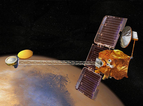
An unknown object apparently collided with a satellite with NASA Langley Research Center connections in November, sending several broken pieces flying into orbit.

The satellite was decommissioned in December 2005, but was one of NASA’s largest and brightest in low-Earth orbit, and popular among amateur sky watchers. Called UARS, Upper Atmosphere Research Satellite, it was launched in 1991 and carried a NASA Langley instrument called HALOE that captured data about the chemistry of the atmosphere.

On Nov. 10, something apparently hit the school bus-sized orbiter. It could have been one of the many pieces in a growing field of "space junk." It could have been a meteoroid. Space debris often leaves pings and dents in satellites and even the space shuttle, and aging satellites decay over time. But a collision that actually creates new pieces of debris is more rare.

"When I heard this, I was shocked," said Jim Russell, a Hampton University professor who was the project lead for HALOE. "This is very unexpected. That’s not normal decay."

Nicholas L. Johnson, chief scientist for NASA’s Orbital Debris Program, said it remains unclear what happened to UARS. Four pieces bigger than 4 inches in diameter — roughly the size of a trackable piece of space junk — were sent into orbit, but it is unclear how large those pieces are.

A collision from a meteoroid or another piece of debris is the best hypothesis, Johnson said. The core of the spacecraft appears to still be intact.

"Unfortunately, we might not ever learn what caused the event," Johnson said.

Mark Matney, who works with Johnson in the Orbital Debris Program, said satellites with still-functioning pressurized systems sometimes eject new debris if a tank explodes. But UARS had no such systems, so a collision is the best explanation.

Only three known collisions between two satellites have ever occurred, Matney said. But these "anomalous" events, where it’s not clear what one of the colliding objects was, do happen occasionally, he said.

"It’s very hard to determine," what might have hit UARS, Matney said.

Decommissioned satellites typically continue to orbit for years before losing energy and falling toward Earth, usually to burn up. UARS was expected to fall out of orbit around 2011, Russell said.

UARS weighed about 13,000 pounds and measured 35 feet long and 15 feet wide, perhaps making it a better target than most.

The U.S. Space Surveillance Network, run by the Air Force, estimates there are about 10,000 objects in low-Earth orbit that are larger than 4 inches. The network’s sensitive ground-based instruments can track those objects. The objects range from communication satellites to the International Space Station to junk — pieces of decaying satellites and the remnants of rocket boosters.

The field of debris has become an increasing concern as the number of pieces continues to increase. The debris field was also significantly expanded in January of this year, when China angered the U.S. and other nations by testing an anti-satellite missile. The Chinese destroyed their FY-1C satellite, an aging weather observer.

The missile test exploded the satellite into more than 1,000 pieces of debris, and U.S. intelligence and defense analysts almost immediately deduced what had happened, before the Chinese government admitted it a few weeks later.

The UARS collision created only a handful of new pieces of debris, but still, "You hope it’s not anything sinister," said Ellis Remsberg, a Langley scientist who worked on HALOE with Russell.

Two of the "large" pieces that broke off UARS have apparently already burned up in the atmosphere, Johnson said. The other two pieces will likely do the same.

What remains of the craft’s core will continue to orbit for some time — barring another collision.


Dude, Where’s My Satellite?

Monday, December 17th, 2007

My grandmother used to say that a good scare could take five years off someone’s life. Is that what happened to India’s Insat-4CR satellite?


              Missing?
 

"One of the best-kept secrets of the Indian Space Research Organisation (Isro)" is that Insat-4CR (the launch of which we blogged about in September) "’disappeared’ in space about a month later," according to Daily News Analysis:

The satellite, which has 12 transponders meant for defence applications, direct-to-home (DTH) services and news gathering for television channels, was, however, “spotted” again with the help of the US-based National Aeronautics & Space Administration (Nasa) and brought back to a near geosynchronous orbit (36,000 km above earth). This took 15 days of manoeuvres, which consumed fuel normally meant for five years. This means the life of the satellite has come down from 10 years to five years.

A satellite’s life is determined by its fuel supply. As it keeps drifting in space, it has to be propelled back to the desired orbit using precious fuel.

A highly-placed source told DNA that Insat-4CR “disappeared” some time in October, almost a month after its orbit was raised for the fifth time to a near-geosynchronous orbit from the master control facility (MCF) at Hassan in Karnataka on September 7. The GSLV-F04 launch carrying Insat-4CR was critical for Isro after it lost Insat-4C #one minute after launch on July 10, 2006. Insat-4CR had a perfect launch, but the unusual drift in space was totally unexpected. Insat-4CR, weighing 2,130 kg, is identical to Insat-4C.

When its tracking systems failed to locate the satellite, Isro sought help from Nasa. The Nasa Orbital Debris Program Office located it a few days later. “Reclaiming the satellite was no mean achievement,” said the source, “but in the process, the satellite lost fuel meant for five years.” 

ISRO’s satellites are tracked from a giant 32 meter antenna installed at the Indian Deep Space Network (IDSN) at Byalalu, 40 km from Bangalore.

ISRO has denied the report that Insat-4CR went missing: "It’s totally false and baseless. We totally deny it," ISRO spokesperson S Satish said.

SWE-DISH to Help Spanish TV

Friday, November 30th, 2007

Some good news for DataPath’s Swe-Dish portable satellite terminals:

SWE-DISH Satellite Systems AB,a DataPath company, has received an order for up to 20 SWE-DISH Drive-Away 150systems for several Spanish broadcasters, primarily Television Espanola (TVE).The agreement was secured in close cooperation with SWE-DISH’s Spain-basedsales and service partner, Atlas Sistemas. TVE will base 16 of thevehicle-mounted 1.5-meter antenna systems throughout Spain, giving thebroadcaster greater mobility to produce high-quality live broadcasts of localnews and events.

The news comes on the heels of last month’s announcement that the United States Marine Corps has selected Swe-Dish for one of its new programs: 

DataPath, Inc., a leading provider of satellite and wireless communications networks around the world, has been selected by the U.S. Marine Corps to provide an ultra-portable satellite communications (SATCOM) solution for the Support Wide Area Network (SWAN) program, enabling the Marines to extend the network and improve warfighter mobility while they establish and maintain broadband communications on the battlefield.

The DataPath solution will include:

– SWE-DISH IPT Mil Suitcases (AN/USC-68), quick-to-air terminals that are small enough to be carried as suitcases or backpacks.

– Customized, portable baseband kits providing NIPRnet, SIPRnet and voice-over-IP services.

– Technical support services that include training and field engineering from DataPath’s experienced support personnel.

The multi-year contract award, with options, could total up to approximately $30 million, including an initial delivery order of $1 million.

From the Swe-Dish website, in English (da da dum):

SWE-DISH Satellite Systems has developed a new class of groundbreaking small satellite terminals – the Suitcases. It’s a new class of small (suitcase size), hand portable, highly mobile and fully automated satellite terminals. They are used by numerous leading broadcasters, as well as several defense organizations such as the US Special Operations Command.

The Suitcase is recognized for being
• Compact and hand-portable
• Fast, one-person operation with a unique, user-friendly, Graphical User Interface
• Motorized set-up and antenna positioning
• No requirement of specially trained personnel
• LAN standard – working like any LAN through 10/100 base-T interface
• Rugged – used by military units world wide

It’s as light as a bag of cement — watch them lift the suitcase in this video:


France et Chine

Thursday, November 29th, 2007

That was some trip to China by French president Nicolas Sarkozy — got a lot of good press, too. Better than that 60-minutes interview in October.

Big nuclear power plant deal for Areva and some airplanes for Airbus to deliver — and Eutelsat CEO Giuliano Beretta made the trip, scoring an interview with China Daily. Nice profile on Areva CEO Anne Lauvergeon. Incidently, Areva is now the parent company of Canberra Eurisys, developers of the titanium-encapsulated germanium detector on board NASA’s Mars Odyssey orbiter.

Are people concerned about all this technology transfer? We blogged about the Long March rocket launch of  Thales Alenia Space-built Chinasat 6B ("Zhongxing-6B") — which is a pretty advanced bird. Sarkozy’s not worried at all:

French President Nicolas Sarkozy said yesterday that he did not fear technology transfers to China, speaking a day after Areva of France signed a landmark deal to deliver state-of-the-art nuclear reactors.

“In the nuclear field, we’re going to create a joint venture.  I’m not worried about technology transfer,” Sarkozy told students at Beijing’s elite Tsinghua University, referring to the Areva deal.

I’m all for cleaner energy and better satcom for all. Even the A380 is billing itself as "cleaner & greener." Here’s an A380 performing a cross-wind test in Iceland, as documented by Icelandic TV:


Where the heck am I?

Thursday, November 29th, 2007


Wow, now I know. Thanks to a new "killer app" from Google called My Location. The folks at AppleInsider see it:

New Google Maps feature could simulate GPS on iPhones

By Slash Lane

A new version of Google Maps introduced this week includes a beta feature dubbed My Location that was designed to simulate the GPS experience on mobile phones and handheld devices that do not include GPS hardware, like Apple’s iPhone.

Essentially, the My Location feature takes information broadcast from mobile towers near non-GPS equipped mobile phones to approximate the device’s current location on the map down to about 10 city blocks.

"It’s not GPS, but it comes pretty close (approximately 1000m close, on average)," the Mountain View, Calif.-based search giant explained on its website. "We’re still in beta, but we’re excited to launch this feature and are constantly working to improve our coverage and accuracy."

The My Location feature is currently available for most web-enabled mobile phones, including Java, BlackBerry, Windows Mobile, and Nokia/Symbian devices. However, it is not yet compatible with Apple’s iPhone.

Still, Apple has promised to continuously update and improve upon the feature set of its inaugural mobile handset, making it more than likely that the feature will turn up once it emerges from the beta stage.

For a more detailed explanation of My Location and a visual demonstration, please see the video below.


Just downloaded it on a BlackBerry and it works. Amazing.