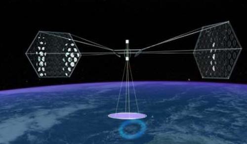
Here’s an interesting proposal to meet our future energy needs, perfectly timed with Al Gore’s receipt of the Nobel Peace Prize and the heightened awareness that brings to the need for clean, non-carbon energy:
A futuristic scheme to collect solar energy on satellites and beam it to Earth has gained a large supporter in the US military. A report released yesterday by the National Security Space Office recommends that the US government sponsor projects to demonstrate solar-power-generating satellites and provide financial incentives for further private development of the technology.
Space-based solar power would use kilometre-sized solar panel arrays to gather sunlight in orbit. It would then beam power down to Earth in the form of microwaves or a laser, which would be collected in antennas on the ground and then converted to electricity. Unlike solar panels based on the ground, solar power satellites placed in geostationary orbit above the Earth could operate at night and during cloudy conditions.
"We think we can be a catalyst to make this technology advance," said US Marine Corps lieutenant colonel Paul Damphousse of the NSSO at a press conference yesterday in Washington, DC, US.
The NSSO report recommends that the US government spend $10 billion over the next 10 years to build a test satellite capable of beaming 10 megawatts of electric power down to Earth.
A rocket carrying a satellite used for communication by the United States Air Force lifted off Wednesday night.
The Atlas V, which launched at 8:22 p.m. (0022 Thursday), is carrying a Wideband Global SATCOM satellite. It is the first of at least five satellites that will be placed in orbit through 2008.
The system will replace the current Defense Satellite Communications System that has been used for military communications for the last two decades. This first satellite will cover the Pacific Zone which includes Hawaii, Japan and Southeast Asia. Each spacecraft will cost $350 million (€247.42 million).
The DSCS system will be used in conjunction with WGS until being phased out within the next few years.
Col. David Urich, the Military Satellite Communications Systems Wing vice commander, said the first spacecraft alone "will provide more capacity than all the current DSCS satellites currently in use."
The launch was scheduled for Tuesday, but delayed a day as engineers checked data that might have indicated the Atlas V rocket would have fallen short of its intended orbit.
Here’s some big news from the world of direct-to-consumer satellite broadband marketing:
Hughes Network Systems, LLC (HUGHES) today announced that consumers across North America will be able to purchase HughesNet®, the leading satellite broadband Internet access service, from Wal-Mart, giving customers in rural areas the opportunity to experience the benefits of high-speed Internet access. The HughesNet service will be sold in 2,800 Wal-Mart stores across the U.S., including locations throughout most of rural America where terrestrial broadband services, such as cable and DSL, are often not available.
With HughesNet, consumers in any region in the continental U.S. need only a view of the southern sky to have access to high-speed Internet. And with millions of Americans shopping at Wal-Mart each week, being able to purchase HughesNet at the stores makes broadband more accessible in many more areas across the country than ever before.
[T]he market for satellite broadband is small, given the widespread availability of digital subscriber line access from phone companies and cable modem services from cable operators. Currently, satellite service tends to be more expensive and it’s available mainly in hard-to-reach rural areas. Fewer than 500,000 Americans subscribe to satellite broadband access, according to consultancy Parks Associates. "It’s still mainly for people who don’t have a choice," says Michael Cai, an analyst at Parks. Only about 10% of Americans have no access to DSL or cable broadband.
But Wal-Mart, which will provide satellite broadband in 800 stores, could make the service more appealing—and give existing providers cause for concern. Whenever Wal-Mart enters a new market, it tends to push down prices and squeeze out competition. Consider what happened when Wal-Mart began offering sub-$1,000 flat-panel TVs. After trying to match these prices, rival Circuit City (CC) had to close 70 stores (BusinessWeek.com, 4/23/07) and lay off 3,400 employees earlier this year. CompUSA had to shutter more than half of its stores.
Wal-Mart could have a similar impact on sellers of broadband services, especially if the Hughes deal presages a bigger push into services related to high-speed Internet access. Retailers are stepping up their emphasis on services, partly in response to Wal-Mart’s penchant for bargain-basement prices.
Broadband Reports says Walmart is "working on a tech support service akin to Best Buy’s Geek Squad," in order to support the new offerings as well as to combat the high return rates that tend to accompany the sale of new technology to consumers who still haven’t figured out how to program their VCR DVD.
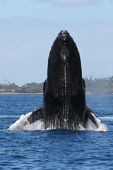
For decades, Japan’s scientific whaling program has killed thousands of whales as part of what it calls necessary research.
Needless to say, Japan’s whaling program has been a point of contention with the environmental group Greenpeace for just as long.
Now, however, Greenpeace is leading the fight against whaling a different way — by example:
Greenpeace announced a satellite-based tracking system to monitor endangered South Pacific humpback whales, saying it is not necessary to kill the animals as Japan does to study them…
Humpback whales from Rarotonga and New Caledonia have been satellite tagged and are "now being tracked in order to produce vital data on their movements, habitat use and population structure," said Greenpeace New Zealand’s oceans campaigner, Mike Hagler.
"The tagging program is producing real scientific results" on whale migrations from breeding grounds in the South Pacific to feeding grounds of the Southern Ocean "without firing a single harpoon," he said.
Tracking whale migration is critical to developing plans and policies to preserve the species; satellite tracking is a natural solution to the problem of tracking big mammals in an even bigger ocean. Whalenet has a good description of how satellite tracking works for whales:
WhaleNet uses satellite transmitters that send signals to satellites maintained by the ARGOS System in Largo, Maryland and Talouse, France. A number of the U.S. National Oceanographic and Atmospheric Administration’s (NOAA) weather satellites, circling the earth, have ARGOS instruments attached. These instruments collect, process and disseminate environmental data relayed from fixed and mobile transmitters worldwide. What makes ARGOS’s system unique is the ability to geographically locate the source of the data anywhere on the Earth.
Data is collected by the tag while the marine animal is underwater and then transmitted when the animal surfaces. The tag has an antennae which is used to send a signal each time the animal surfaces. Information relayed includes time, date, latitude, longitude, dive depths, dive durations, amount of time at the surface in the last six hours and quality of the transmission. The ARGOS instruments detect the tag’s signal when the satellite passes overhead.
The location fix of the animal in relationship to the track of the satellites, with ARGOS instruments, affects how many satellites passes are made over the animal’s tag in a 24 hour period. Each pass may last between 2 and 12 minutes, depending on the location of the satellite in relation to the animal. The animal must be at the surface at the time of the pass for a successful transmission to take place. Therefore, each day there are a limited number of short opportunities, or maybe no opportunities, for a signal to be transmitted from an animal’s tag to a satellite.
How are they attached?
With whales the tag is attached by partially implanting a barb into the blubber layer at a slight angle, to a depth of approximately 10 cm. Ideally it is placed high on the back of the whale, directly behind the blow hole. These tags are deployed using a compound crossbow. A study by the Minerals Management Society determined that this does not cause serious stress or pose a health risk to the whale. The tagging team goes out in a 4 meter rigid-hull inflatable equipped with an outboard motor in order to get close enough to the whale to implant the tag.
There’s no relation, we hear, between the satellite tracking of whales and the chip implants for your pet.
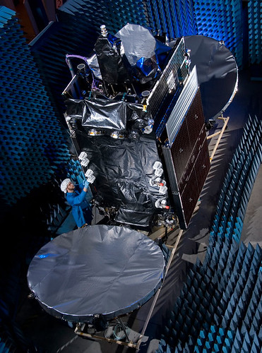
Taking a look (and translating) the Proton launch manifest, we see that the Sirius 4 satellite (pictured above) is set to lift later this month, pending review of the causes behind the launch failure of the JCSAT 11 satellite from Baikonur:
SIRIUS 4 is a multi-mission Ku/Ka-band satellite. It is built on Lockheed Martin’s reliable A2100AX platform. SIRIUS 4 will be deployed at orbital position 5 degrees East.
SIRIUS 4 will be the biggest satellite and a welcome addition to the SIRIUS satellite fleet. The satellite is intended to meet today’s growing demands and tomorrow’s new challenges. SIRIUS 4 will enhance capacity and widen the coverage of Eastern Europe.
Following Sirius 4 on successive Proton launches will be Telenor’s THOR 5 bird, which has 24 transponders with three times more payload power compared to the current THOR II satellite that it replaces, as well as the AMERICOM-14 satellite.
Sirius is in competition with Telenor for not only the Scandinavian market (where the Thor 5 delay may be impacting the introduction of a new children’s channel, NRK Super) but for Central and Eastern Europe as well.
THOR 6 will be based on Thales Alenia Space Spacebus 4000B2 platform and fitted with 36 active Ku-band transponders. 16 transponders will point to the Nordic countries, and 20 transponders will be positioned to serve the growing broadcasting demands within Central and Eastern Europe. With the launch of THOR 6, the 1° West will have a total of 71 transponders providing capacity to facilitate both organic growth and expansion for Telenor.
Call it serendipity: as members of the satellite industry prepare to attend the Satellite and Broadcast Expo West in Reno at the end of this week, the Tahoe Daily Tribune observes that there are a heck of a lot of dishes in the area:
More and more, satellite dishes are becoming a fixture in the South Shore scenery, in a sign that satellite providers may be gaining ground in the battle for pay-TV subscribers.
Although cable and satellite providers are shy about revealing raw data concerning subscribers, it seems that satellite TV is becoming the choice of more South Shore residents.
Frank Giardina, owner of Frank’s TV and Electronics on Lake Tahoe Boulevard, estimates that he has installed 1,600 satellites dishes in the area. Frank’s serves as an independent contractor for Dish Network, making them the only "local" satellite provider in the area.
SBE West has a number of great special events at the show. We’re particularly intrigued by the John Hack Technician Challenge:
Imagine digging through a bucket full of change, connectors, bolts and washers just trying to find enough money to buy $5.00 worth of gas to get to your first install of the day! That task and more is what contestants in the John HackTechnician Challenge will be facing at SBE 2007 in Reno. Consider it a fun and exciting, timed obstacle course for satellite technicians. How long would it take you to put 50 pages of work orders in the correct sequence for faxing at the end of the week? We will know at the end of the Technicians challenge.
We think John Hack is a great name for a technician. For those unfamiliar with "him," he started as a column in Transmitter News. You can find his full bio and news about his exciting projects here.
They’ll be up early in Sydney, Australia, on Saturday morning, watching a rocket launch their new satellite — and the same goes for Intelsat in Pembroke, Bermuda, too.
For the past few weeks, Orbital Sciences has been very busy at Europe’s Spaceport in Kourou preparing for their "double-header:" they built both "passengers" set to be carried by Arianespace. Looks like a "go" for an Ariane 5 (GS configuration) launching Optus D2 and Intelsat 11 on Friday, 5 October 2007:
Arianespace’s fourth mission of 2007 is set for Friday, October 5, with the green light given today after the launch readiness review at Europe’s Spaceport.
This review, which is held before every Ariane flight, verifies the readiness of the Ariane 5 vehicle, its two payloads, the launch infrastructure at the Spaceport in French Guiana, and the downrange network of tracking stations.
The upcoming mission will orbit two medium-sized satellites built by the same U.S. manufacturer, Virginia-based Orbital Sciences Corporation, for Intelsat and Optus.
The Intelsat 11 spacecraft is riding in Ariane 5’s upper payload position, and is to be released first in the mission sequence. To be operated by Washington, D.C.-headquartered Intelsat, the satellite will host Latin America’s premiere video programmers and the region’s largest DTH (direct-to-home) platform. Intelsat 11 is based on the Orbital Sciences STAR 2 spacecraft bus, and carries a hybrid payload composed of 16 C-band and 18 Ku-band transponders. The satellite weighs approximately 2,500 kg. at launch.
Optus D2 also uses an Orbital Sciences STAR 2 bus, and is to be operated by Australian-based Optus to enable the development of new business opportunities for the direct-to-home market, new data services and services bundling. Positioned at an orbital slot of 152 deg. East, the 2,350-kg.
45-minute launch window opening, by city:
GMT: 21:28 on 5 OCT 2007
Luxembourg: 23:28 on 5 OCT 2007
New York: 17:28 on 5 OCT 2007
Kourou, French Guiana (local time): 18:28 on 5 OCT 2007
NPOESS will use polar-orbiting satellites to observe Earth from space. The satellites will collect and disseminate data on Earth’s weather, atmosphere, oceans, land, and near-space environment. The polar orbiting satellites are able to monitor the entire planet and will bring improved data and imagery that will allow better weather forecasts, severe-weather monitoring and detection of climate change.
The raw data collected by the NPOESS satellites is then modelled at the U.S. based weather data centres and distributed to a global user population which includes bodies such as bureaus of meteorology.
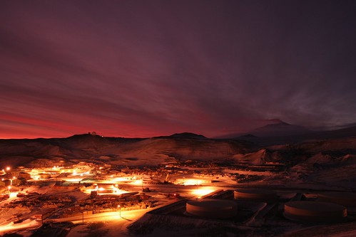
The National Science Foundation (NSF) manages and funds the U.S. Antarctic Program (USAP), which coordinates all U.S. research on the southernmost continent. McMurdo is one of three year-round stations NSF maintains in Antarctica, the others being Amundsen-Scott, at the geographic South Pole, and Palmer, on the Antarctic Peninsula. The National Science Foundation and NPOESS are jointly collaborating on the development of McMurdo as one of the NPOESS weather downlink stations and intend to share the satellite service provided by Optus.
Optus has been working closely with Raytheon Company in the provision of the SafetyNet™ system which is a network linking 15 satellite antennas to the weather data centres. Data collected by the NPOESS satellites is capable of being downloaded to any of the receptor sites installed at key locations around the globe. Each of the sites, with the exception of McMurdo Station, is connected via a fibre cable network to the system data centres. The data collected in McMurdo will be transferred via the Optus D1 satellite to the fibre network in Sydney, Australia.
"We believe the D1 satellite coverage will make a real difference to the McMurdo Sound facility. Optus Satellite will be delivering a unique communications solution to meet our customers’ specific requirements. It also further cements our position as the premium supplier of satellite services in our chosen markets," said Mr. Sheridan.
The NSF Black Island satellite earth station facility, located 20 km distant from McMurdo on a desolate, wind-swept island, will establish the link with Optus D1. In addition to supporting NPOESS data transmissions, NSF will more than triple its current data communications capability for the USAP, a significant benefit to the science research program, as well as to the health and safety of more than a thousand people.
Time-lapse video filmed in Antarctica, in and around McMurdo Station and Scott Base.
Each year the sun is below the horizon for 4 months in the middle of winter, and above the horizon for 4 months in summer. During the couple of months in between we have more-or-less normal days.
Includes shots of auroras and the very rare polar stratospheric nacreous clouds, which form when ozone depleting gases crystallize in the upper atmosphere in the intense cold.
Summer population is about 1200 people, winter about 200.
This is just a small sample of an ongoing project to collect time-lapse imagery of Antarctica. I have taken over 1,000,000 individual photos and worn out a number of cameras that make up the collection of footage I have gathered so far over the last 5 years.
The brutal crackdown of nationwide protests in in Myanmar last week has led to strong international condemnation of the military junta in Burma, while images and video of Burmese soldiers attacking Buddhist monks, who led many of the demonstrations that grew to as many as 100,000 before the crackdown began, have gripped the world media.
But the public dispersions of the protests haven’t been the junta’s only violent attempts to crack down on dissent. A new analysis of high-resolution satellite images completed by the American Association for the Advancement of Science (AAAS) "pinpoints evidence consistent with village destruction, forced relocations, and a growing military presence at 25 sites across eastern Burma where eyewitnesses have reported human rights violations," according to the AAAS website:
The research by AAAS, a non-profit, non-partisan organization and the world’s largest general scientific society, offers clear physical evidence to corroborate on-the-ground accounts of specific instances of destruction. It is believed to be the first demonstration of satellite image analysis to document human rights violations in Burma, also known as Myanmar.
Patches of scorched earth corresponding to settlements reportedly destroyed are visible in the high-definition photographs taken by satellites zooming in on the secretive state in late April and analyzed by the Washington-based American Association for the Advancement of Science (AAAS).
Now the group has trained the satellites on Myanmar’s main cities to try and peer through the clouds and see military deployments amid the current unrest, as the crackdown on pro-democracy protests led by monks has turned bloody.
In Karen areas of eastern Myanmar, the group used three commercial satellites to focus on 31 "attack sites" of reported rights violations from mid-2006 to early 2007, AAAS project director Lars Bromley told reporters Friday.
In one picture, a satellite spotted foundations and fence lines with all the structures gone, where a village had stood two years earlier.
The area photographed was the site of a reported military raid on April 22, on Karen villagers accused by the regime of supporting armed rebels. Bromley estimated a dozen people were killed there and the rest fled.
The image on the left, above, shows a settlement adjacent to rice paddies in 2000. The image on the right shows the same area in December 2006. This area was reported attacked in April 2006. Check out this ABC News slideshow for additional photos from AAAS.
The reentry capsule for the Foton-M3 spacecraft, which has been in low-Earth orbit for the last 12 days, successfully landed this morning in an uninhabited area 150 km south of the town of Kustanay in Kazakhstan, close to the Russian border, at 09:58 CEST, 13:58 local time.
The unmanned Foton spacecraft, which was launched on 14 September from Baikonur Cosmodrome, in Kazakhstan, carried a payload of 43 European experiments in a range of scientific disciplines – including fluid physics, biology, crystal growth, radiation exposure and exobiology.
The mission was intensively monitored throughout by 65 engineers and scientists located at ground stations at Esrange, in Kiruna, Sweden, and at the Russian flight control centre, TsUP, in Moscow, Russia. Thanks to a close cooperation with the Canadian Space Agency, ground stations in St. Hubert and Saskatoon were also used to receive data from the spacecraft.
“I am extremely pleased with the success of the Foton-M3 mission,” says Josef Winter, Head of ESA’s Payload and Microgravity Platform Division. “All operations during the mission were flawless. The hard work and dedication of all involved has contributed to make this mission a success. I would like to congratulate our Russian counterparts and thank them for their outstanding cooperation.”
Helicopters were immediately at the landing site to start recovery operations, including the retrieval of experiment hardware. The European experiments will now be returned to the labs at ESA’s research and technology centre, ESTEC, in Noordwijk, the Netherlands, tomorrow evening. After further inspection at ESTEC the experiments will be returned to the scientific institutions where the data will be analysed over the coming months.
Only in-depth analysis will reveal the full extent of the scientific return of the mission, although data received during the flight already shows promising results – the Italian and US team responsible for the GRADFLEX (GRADient-Driven Fluctuation EXperiment) experiment received preliminary confirmation of a 10-year-old fluid science theory.
A further highlight of the mission was yesterday’s deployment of a small reentry capsule from the outside of the Foton spacecraft. The Second Young Engineers’ Satellite (YES2) experiment saw the release of the beachball-sized Fotino capsule from the end of a tether to demonstrate the smart possibility of returning small payloads to Earth.
"I am extremely satisfied that we could fly a very high number of experiments during the Foton-M3 mission and that they all worked out well. Some of them will even be further elaborated onboard the International Space Station," says Martin Zell, ESA’s Head of Research Operations for the Directorate of Human Spaceflight, Microgravity and Exploration.
The experiment was some coverage in the almost-science press this week. Wired, for example:
The students’ critical moment came today, and so far it’s a qualified success. The payload, a small capsule dubbed “Fotino” was intended to be let out on a 18.6 mile, fishing line-thin tether before being released. But the process went more slowly than projected, and the little test capsule was cut loose by a preprogrammed command after just 5.2 miles.
European Space Agency scientists are currently tracking the little device to figure out where and how its parachute will bring it back to earth.
The mishaps may mean that the students’ tether system won’t find its way immediately into adoption for critical satellite or other launches. But the test gives space programs around the world new data on an innovative and potentially money-saving technique for orbital deployments.
They’re right about how cool this mission was. Here’s their animation:
Still no word on whether the prog-rock group Yes is comtemplating a copyright infringement complaint.

 For decades, Japan’s scientific whaling program has killed thousands of whales as part of what it calls necessary research.
 Call it serendipity: as members of the satellite industry prepare to attend the