Dark matter makes up more than 90% of the universe, yet because it neither emits nor reflects electromagnetic radiation, it cannot be observed directly.
Yet a group of astronomers in Baltimore have used the Hubble Space Telescope "to map the dark matter billowing out from the long-ago collision of two galaxy clusters."
The photo released by NASA is quite extraordinary:
They’re calling it the strongest evidence yet of the existence of dark matter, and the first observation to separate it from its associated stars, galaxies and glowing gas.
"What we found is a very peculiar structure – a ring-like structure that surrounds the core of the cluster," said Johns Hopkins University research scientist M. James Jee, lead author on the study that will appear in the June 1 issue of The Astrophysical Journal.
It’s not exactly a ring of dark matter, he said. Rather, it’s a map of where the densest regions of dark matter must be, based on measurements of how that mass and gravity are bending the light streaming by from galaxies far in the background….
Jee likened the ring (in three dimensions actually a flattened spherical shell) to a jam-up of dark matter particles hurled outward from the collision, like commuters headed out of town, backing up behind slowing traffic ahead.
The Sun article notes that there is skepticism among some astronomers, who would like to see the evidence captured from a second source to rule out "peculiarities" in Hubble’s camera. Perhaps the image above is simply the astronomical equivalent of refracted light on film appearing as a "ghost" in your family photographs. Nonetheless, the evidence for dark matter is there, whether we’ve observed it yet or not.
(Also be sure to click here for a related video simulation of two galaxy clusters colliding.)
Watch this Hubblecast to better understand the significance of this finding.
THE SRI LANKAN EMBASSY in Washington has complained to the US Justice Department, State Department and the Federal Bureau of Investigation (FBI) against Washington based Intelsat Ltd., for reneging its promise of removing the National Television of Tamil Eelam (NTT) channel and Pulikalin Kural radio from the Intelsat 12 satellite transponder and for continuing to facilitate and broadcast terrorist propaganda.
Before lodging the complaint, the Sri Lankan Embassy brought to the communication satellite company’s notice that despite its assurance that it has removed both channels from its transponder, it continues to broadcast National Television of Tamil Eelam, and Pulikalin Kural (Voice of Tigers radio) the official television and radio of the LTTE.
Intelsat Ltd., according to sources, laid down conditions to the Sri Lanka Embassy that talks with them should not be publicised or divulged to anyone which the Embassy refused even to consider.
Subsequently, the Sri Lankan Embassy alleged that the satellite provider is violating US law by continuing to broadcast the propaganda television and radio services of the foreign terrorist organisation LTTE, through the satellite they own despite public assurances given ago to the contrary.
National Television of Tamil Eelam, the official television channel of the LTTE is a free-to-air channel to Asia and an encrypted channel to Europe.
The four-hour daily programme of the NTT channel broadcasts propaganda material of the LTTE, a terrorist organisation banned in United States of America, Canada, India and in European Union countries.
The illegal transmission of the NTT channel of the LTTE was for the first time brought to Intelsat Ltd’s notice by Asian Tribune on March 10.
Dianne VanBeber, Intelsat Ltd Vice President in charge of Investor Relations and Corporate Communication, told ‘Asian Tribune’ that the LTTE is pirating the Intelsat’s 12 bandwidth without the company’s knowledge.
"Intelsat has notified the original customer for the capacity that they are in violation of their contract, and Intelsat has informed them to cease transmissions," VanBeber said.
Asked to identify the original customer of Intelsat, VanBeber refused to disclose the service provider’s name who has accommodated the LTTE’s media without Intelsat Ltd’s knowledge.
Asked whether Intelsat was not aware that the LTTE’s National Television of TamilEelam was using the Intelsat 12 satellite bandwidth since 2005, she clarified that Intelsat Ltd acquired PanAmSat only on July 3, 2006, and LTTE’s National Television of Tamil Eelam might have come to quietly share the Intelsat 12 satellite.
She said: "We are taking action to cease their transmission soon." Subsequently this issue was taken up by Bernard Goonetilleke, Sri Lanka’s Ambassador in Washington with Intelsat’s General Counsel, Phillip Spector.
A press statement was released by the Intelsat after the meeting.
In a press statement dated April 10 Intelsat Corporation said: "Intelsat officials, including its technical experts, met with Sri Lanka’s Ambassador to the United States, Bernard Goonetilleke, on April 10 to discuss the steps Intelsat is taking to address the unauthorised use of one of its satellites by the LTTE.
During the meeting, Intelsat’s General Counsel, Phillip Spector, said:’ "Intelsat does not tolerate terrorists or others operating illegally on its satellites. Since we first learned of the LTTE’s signal piracy, we have been actively pursuing a number of technical alternatives to halt the transmissions. We are clear in our resolve to ending this terrorist organisation’s unauthorised use of our satellite’."
Later, the Sri Lankan embassy revealed that Intelsat Ltd., stated that during April 21-22 they switched off the transponder of the free to air NTTE channel beamed to Asia and the encrypted channel beamed to Europe.
The Lyngsat site confirms that both the television and radio broadcasts were up and running on 29 April 2007 — nearly three weeks after we first blogged it. The program can be found every day, from 18:00 to 21:30 GMT, on Intelsat 12, transponder 2 (downlink frequency: 11,504 Vertical; symbol rate: 2894; FEC: 3/4).
How did that happen? If you read ToTheCenter.com, you’d think it was indeed turned off:
INTELSAT INFORMS SRI LANKA EMBASSY IN WASHINGTON IT SWITCHED OFF LTTE BROADCASTS FROM THEIR SATELLITE
( By Walter Jayawardhana)
Sri Lanka’s envoy in Washington, D.C. said his office had been given an assurance by Washington based Intelsat Corporation that they have switched off the transponder used by the Liberation Tigers of Tamil Eelam (LTTE) to broadcast its propaganda, during the last weekend.
“We were told last evening by Intelsat executive Phillip Spector that the transponder used by the LTTE was switched off during the weekend,” Bernard Goonetileke, Washington, D.C.’s Sri Lankan Ambassador told this correspondent.
However, Goonetileke said he was still not sure whether the banned terrorist group has made some other arrangements with a European satellite company to carry on with the broadcasts continually.
He said inquiries are made to check whether LTTE is continuing its broadcasts and whether they are doing it through another channel, suspected to be Globe Cast satellite of a European company.
A press release issued by the Washington, D.C. Embassy of Sri Lanka said, “Intelsat Ltd., a U.S. based satellite company has terminated the “unauthorized” use of one of its satellites, Intelsat12, by the Sri Lanka based terrorist organization, the Liberation Tigers of Tamil Eelam (LTTE), for its TV and radio transmissions to Europe and Asia.”
The Executive Vice President and General Counsel of Intelsat Ltd., Mr. Phillip Spector, confirmed to Rajika Jayatilake, Counselor (Information) at the Sri Lanka Embassy in Washington, D.C., that Intelsat Ltd. had, over the April 21/22 weekend, shut down the transponder, which the LTTE had used for its transmissions, the press release said further.
Whatever new channel the LTTE is using will have to be advertised through some means since the viewers and listeners of its propaganda have to be informed about the changes in the broadcasting frequencies. So far, no such advertisement has been found.
Following the meeting with Ambassador Goonetileke on April 10, 2007, Mr. Phillip Spector, of Intelsat Ltd., stated that the LTTE transmissions were “unauthorized.” Countering the position taken by Intelsat Ltd., speaking from Sri Lanka’s north to wire services in Colombo, the LTTE denied it was using the satellite services illegally. “We are accessing it legally and there is no signal piracy,” said an LTTE spokesman.
However, inquiries by this correspondent could not find out any evidence to confirm the statement of Phillip Spector, that the LTTE was a pirate of the satellite.
The Embassy press statement traced the history of the LTTE-INTELSAT connection as follows: “Since March 2005, the LTTE had been transmitting TV and radio programs through Europe Star 1 satellite owned by French satellite provider, Alcatel. PanAmSat, a satellite operator headquartered in Wilton, Connecticut in the U.S., acquired Europe Star 1 satellite in July 2005. In July 2006, Intelsat Ltd. acquired PanAmSat, following which, Europe Star 1 satellite was renamed Intelsat12. The programs that the LTTE had been transmitting through Europe Star 1, thus continued uninterrupted even after Intelsat Ltd. acquired the satellite.”
It is believed that it was the intense pressure used by the Washington Embassy of Sri Lanka and the U.S. State Department and the Department of Justice, together with press publicity, that was adversely affecting Intelsat that finally brought an end of the deal.
The Sri Lanka Embassy said, the U.S. Department of State and the Department of Justice had both been informed that a terrorist group designated by the U.S. as a Foreign Terrorist Organization (FTO), was using a satellite owned by a U.S. based satellite company to transmit their TV and radio programs to Europe and Asia. (EOM)
Then we read this from the DARPA Public Affairs Office, via SpaceRef.com:
15 May 2007 Update from Jan Walker, DARPA PAO:
"During Scenario 3-1 execution on the evening of May 11, Orbital Express encountered a serious sensor flight computer anomaly on the ASTRO while stationkeeping at 10 meters separation distance from the NextSat. Onboard fault protection reacted immediately, placing the ASTRO into an abort trajectory which carried it to a hold-point 120 meters from the NextSat. The Orbital Express team has spent the past several days recovering from this fault and from problems associated with loss of relative navigation at the longer-than-anticipated separation distances for this scenario. The ASTRO has since coasted at distances of up to several kilometers from the NextSat. Both vehicles are safe. The ASTRO powered up its redundant sensor flight computer and is processing sensor data nominally. The team is in the process of developing a recovery scenario for ingress and remate, and hopes to execute this ingress in the next several days."
Editor’s 14 May 2007 note: At this point ASTRO and NextSat should be a few meters apart. Some observers are suggesting that they are kilometers apart. No word from DARPA.
"… NEXTSAT appeared to trail by about 0.5 deg, when at a range of about 600 km, which indicates a distance of about 5 km."
The account by New Scientist was more alarming than that:
The US military’s experimental satellite mission, Orbital Express, may be in peril. The lead spacecraft ASTRO has drifted several kilometres away from where it should be.
No updates from Boeing yet, but they’ve got a great team of people working on this mission. I’m sure they’ll recover from this without a scratch.
True to prediction, the much awaited launch of the Nigerian communication satellite, the first of its kind in Africa, took place and went on the 20 to 30 – minute trip into orbit where it is expected to provide robust and reliable satellite services to citizens in Africa and Europe.
The excitement at the site, according to Nigerian officials at the launch, was "electrifying."
Head of Corporate Affairs and Media at the National Space Research and Development Agency (NASRDA), Mr. Felix Ale, told The Guardian on phone that the launch was successful.
He quoted the agency’s Director General Prof. Robert Ajayi Boroffice, as saying that the 30-minute movement of the satellite went on without delay.
According to Ale, "Prof. Boroffice has also called President Olusegun Obasanjo to inform him of the success of the launch. The President was impressed and full of praises for NASRDA.
In addition to be the first communications satellite launched on behalf of an African country, the launch of NigComSat1 also marks a significant first for China, as the first time a foreign buyer has purchased a Chinese satellite and its launching service. The Chinese news service, Xinhua, also points out that the launch represents the culmination and beginning of a relationship between Nigeria and China that will likely continue throughout the life-span of the satellite (about 15 years)…
The satellite will be monitored and tracked by a ground station to be built in Abuja, the capital of Nigeria, by Chinese firm Great Wall Industry Corporation, and a ground station in Kashgar, in northwest China’s Xinjiang Uygur Autonomous Region.
The satellite’s ground facility in Abuja "had the potential of making Nigeria a major traffic hub in the west and central African region" and will prompt Nigeria and neighboring countries to "expand their switching facilities to be able to handle international traffic", according to a Nigerian communication official.
The Chinese company will offer support services and training for Nigerian technicians.
China was awarded the deal in 2004 after it outbid 21 international rivals to secure the 311 million U.S. dollar deal.
And also, may point to China’s expanding relationship with the developing world.
The satellite represents China’s wish to cooperate with developing countries in the peaceful use of outer space and to promote a closer relationship between China and African countries, observers say.
China has signed several cooperative contracts offering commercial launching services for foreign satellites, said an official on space development, citing a similar satellite contract with Venezuela in November 2005 and adding that China has been commissioned to send about 30 foreign satellites into space.
No, not the Governor of New York, although that Spitzer did recently nominate a new Executive Director of the New York State Foundation for Science, Technology and Innovation.
Rather, we’re talking about the first map of an extrasolar planet, HD 189733b, a "hot Jupiter" planet — and the hottest planet yet observed in the universe — which is located approximately 60 light-years from Earth.
The planet is so hot that astronomers believe it’s absorbing almost all of the heat from its star, and reflecting almost no light and thus making its appearance black, as this artist’s rendition of the planet illustrates:
(Live animations of the picture above can be found here.)
NASA explains the mapping project and the resulting discoveries:
Roughly 50 of the more than 200 known planets outside our solar system, called exoplanets, are hot Jupiters. Visible-light telescopes can detect these strange worlds and determine certain characteristics, such as their sizes and orbits, but not much is known about their atmospheres or what they look like.
Since 2005, Spitzer has been revolutionizing the study of exoplanets’ atmospheres by examining their infrared light, or heat. In one of the new studies, Spitzer set its infrared eyes on HD 189733b, located 60 light-years away in the constellation Vulpecula. HD 189733b is the closest known transiting planet, which means that it crosses in front and behind its star when viewed from Earth. It races around its star every 2.2 days.
Spitzer measured the infrared light coming from the planet as it circled around its star, revealing its different faces. These infrared measurements, comprising about a quarter of a million data points, were then assembled into pole-to-pole strips, and, ultimately, used to map the temperature of the entire surface of the cloudy, giant planet.
The observations reveal that temperatures on this balmy world are fairly even, ranging from 650 degrees Celsius (1,200 Fahrenheit) on the dark side to 930 degrees Celsius (1,700 Fahrenheit) on the sunlit side. HD 189733b, and all other hot Jupiters, are believed to be tidally locked like our moon, so one side of the planet always faces the star. Since the planet’s overall temperature variation is mild, scientists believe winds must be spreading the heat from its permanently sunlit side around to its dark side. Such winds might rage across the surface at up to 9600 kilometers per hour (6,000 miles per hour). The jet streams on Earth travel at 322 kilometers per hour (200 miles per hour).
"These hot Jupiter exoplanets are blasted by 20,000 times more energy per second than Jupiter," said co-author David Charbonneau, also of the Harvard-Smithsonian Center for Astrophysics. "Now we can see how these planets deal with all that energy."
As Wired points out, Spitzer’s technology could be used to map Earth-like planets — like the recently-discovered Gliese 581c, which we wrote about here.
For more on the Spitzer Space telescope, check out this great video found in the motherlode of online video, aka YouTube:
The General Services Administration (GSA) yesterday inked deals with 24 satellite communications companies to deliver the next-generation satellite solutions for government agencies, known as Satcom II.
The Satcom II program is meant "to provide an expanded range of end-to-end satellite solutions for government agencies and serves as the primary replacement vehicle for the highly successful Satellite Services contracts."
Among the service providers are nine small business contractors, according to Washington Technology:
The large contractors are Americom Government Services Inc.; Arrowhead Global Solutions Inc.; Artel, Inc.; AT&T Corp.; DRS Technical Services; EDS Corp.; Global Communications Solutions Inc.; Hughes Network Systems LLC; Intelsat General Corp.; Mackay Communications Inc.; Segovia Inc.; Stratos Mobile Network Inc.; Telecommunications Systems Inc.; Telenor Satellite Services and ViaSat Inc. The small business awardees are CVG Inc.; DasNet Corp.; E&E Enterprises Global; Knight Sky Consulting and Associates LLC; New Orleans Teleport Inc.; Psi Systems Inc.; RiteNet Corp.; Satellite Communication Systems Inc. and Skjei Telecom Inc.
The same story provides details on the Satcom II system:
The Satcom II system will allow federal workers to use hand-held receivers similar to cell phones, as well as access full broadband computer networks, anywhere in the world. It is designed for use in areas where no phone or cable lines exist and to help federal workers fight wilderness wildfires, patrol remote borders and rescue the trapped and injured from hurricanes or tornadoes.
The system also makes possible broadcast services in distance learning for federal customers throughout the world…
The GSA press release notes that the "SATCOM-II program has an estimated value of $750 million over the life of the five-year, indefinite delivery, indefinite quantity contracts, and… offers competitive pricing throughout the life of the contract, as well as flexible ordering and billing."
Computerworld also files a report on the contracts, which, while certainly important to the businesses that inked them, essentially provide basic satcom services. The really cool technological breakthroughs (such as the next-stage C4ISR bandwidth, advanced extremely high frequency satellites and Wideband Global Satcom program) tend to come through military contracts.
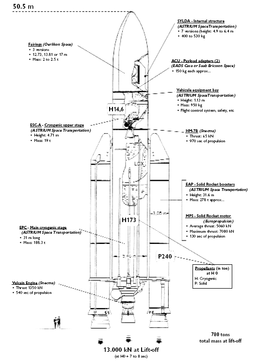
We have a potentially record-setting launch coming up on Thursday, 3 May 2007, from the jungles of French Guiana. We’re talking some heavy payload here. The news via L’Express:
La fusée européenne Ariane 5 doit décoller jeudi soir de Kourou pour mettre en orbite une masse sans précédent constituée de deux satellites de communication.
La masse totale – celle des deux satellites Astra 1L et Galaxy 17 et des interfaces – s’élève à 9,4 tonnes, un record mondial pour un lancement sur orbite géostationnaire, rapporte Arianespace, l’exploitant du lanceur.
Le décollage est prévu à 19h29 (22h29 GMT) du Centre spatial guyanais, la base de l’Agence Spatiale Européenne.
Il s’agit du 176e lancement d’Ariane, du 32e vol d’une Ariane 5 et du 10e d’une Ariane 5 ECA, modèle le plus puissant de la gamme, qui peut mettre jusqu’à dix tonnes sur orbite.
Le satellite Astra 1L doit être placé sur orbite 27 minutes après le décollage et Galaxy 17 cinq minutes plus tard.
Construit par l’industriel américain Lockeed Martin Commercial Space Systems en Californie, Astra 1L a une masse au décollage de 4,1 tonnes, selon Arianespace.
Il sera positionné au-dessus de l’Europe continentale, d’où il assurera la diffusion de chaînes de télévision de haute définition (HD) pour le compte de SES Astra, société du groupe Société Européenne des Satellites (SES), basée au Luxembourg.
I’m making plans to watch it myself. The launch window opens at 22:29 GMT and closes at 23:13 GMT on 3 May 2007. Local time in French Guiana is right after dinner (between 19:29 and 08:13 on 3 May 2007), but I doubt anyone will be able to eat beforehand. Here are some local times:
New York: 18:29 to 19:13 on 3 May 2007
Luxembourg: 00:29 to 01:13 on 4 May 2007
Singapore: 06:29 to 07:13 on 4 May 2007
Live television broadcast begins at 21:50 GMT (17:50 EDT; 23:50 CET):
In Europe, the launch will also be broadcast live via ASTRA satellite from the orbital position 19.2° East (downlink frequency: 12.5515 GHz, vertical polarization, service ID 12122, service name ASTRA Vision 2).
In North America, lock your antenna on Galaxy 3 at 95 West (transponder 22, C-band; Format: digital 9 MHZ, 4126.5 Vertical, FEC: 3/4, Symbol Rate: 6.1113).
According to our friends at ASTRA, the satellite will be performing a critical mission:
ASTRA 1L will be located at 19.2° East, ASTRA’s prime orbital position for delivering broadcast services to continental Europe, where it will also transmit the increasing number of HDTV channels. The new satellite will allow SES ASTRA to move its satellite ASTRA 2C from 19.2° East to 28.2° East, in order to meet the high demand for capacity from the U.K. and Irish markets. It will also extend the ASTRA coverage from the Canary Islands in the West to the Russian border in the East and further strengthen SES ASTRA`s unique in-orbit back-up scheme.
Nigeria is a country best known for its email marketing scams. You know, the ones written in all caps and started off something like…
"Dear Friend, It is with heartfelt hope that I write to seek your co-operation and assistance in the context stated below, I am Barrister Fenner Mark Elvis, the personal Attorney to the late Mr. Nobert Spagele. I got your contact through the help of my brother-in-law that works with the American Chambers of Commerce and Tourism, though I did not disclose to him my humble intention for an honest foreigner like you, having noted the confidence reposed on your person by the sponsor of the recommendation…
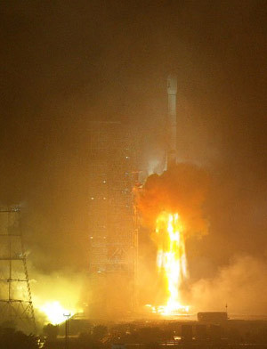
Well, according to SpaceMart, last January a Chinese Bank fell for a similar line and, at present, is financing the construction of Nigeria’s first communications satellite, NigComSat, which is now set to launch before the end of this month.
While this is not Nigeria’s first satellite, a title held, according to allAfrica.com, NigeriaSat-1, launched in 2003 to take photos of Nigeria’s environs, it does mark the first time a Sub-Saharan African country has launched and retained control of their own communications satellite.
Recently "replaced" Nigerian President General Olusegun Obasanjo said that the satellite is a part of his country’s commitment to development:
"This commitment has informed our embarking on programmes and initiatives that would effectively address the challenges of poverty, food security, infrastructural development, sustainable energy, affordable health and housing, and protection from natural and man-induced disasters.
Space technology is key to the realization of the Millennium Development Goals (MDGs) and the objectives of our holistic reform agenda as encapsulated in the NEEDS document. It guarantees the availability and speedy access to real-team data and geo-partial information, as well as the availability of relevant infrastructure and backbone for information communication"
The Chinese, who are financing, building, and launching the project, are also proud of the effort, the first step in a move to develop a satellite design and construction export business. The launch will take place at the Jiuquan Satellite Launch Center, which has launched some 30 satellite since 1990, 24 of which were commercial launches for overseas clients.
The satellite itself is being constructed by China Great Wall Industry Corp., based on China’s latest model of satellite platform, DFH No. 4, and will feature 28 transponders, including 4 C band, 18 Ku band, 4 Ka band and 2 L bands. The whole thing weighs somewhere around 5000 kg and has an anticipated life-span of 15 years.
During the next two years, AIM scientists will methodically address each of six fundamental objectives that will provide critical information needed to understand cloud formation and behavior.
"This mission has many firsts, including that Hampton University is the first historically black college and university to have the principle investigator and total mission responsibility for a NASA satellite mission," said Program Executive Victoria Elsbernd, NASA Headquarters, Washington.
NASA’s Kennedy Space Center, Fla., is responsible for launch vehicle/spacecraft integration and launch countdown management. NASA’s Goddard Space Flight Center, Greenbelt, Md., is responsible for the overall AIM mission management in collaboration with Hampton University, the University of Colorado, Boulder, and Virginia Polytechnic Institute and State University, Blacksburg. Orbital Sciences Corporation, Dulles, Va., is responsible for providing the Pegasus XL launch service to NASA.


 China’s Sichuan Province just after midnight this morning. The Nigerian paper The Guardian had some of
 The General Services Administration (GSA) yesterday inked deals with 24 satellite communications companies to deliver the next-generation satellite solutions for government agencies, known as Satcom II.