Archive for the ‘Observation’ Category

Satcom, Chicago

Wednesday, April 4th, 2007


As Robert Johnson wrote… 

Now, one and one is two, two and two is four
I’m heavy loaded baby, I’m booked, I gotta go
Cryin’ baby, honey, don’t you want to go
Back to the same old place, my sweet home Chicago

70 years later, still sounds good. In fact, Amazon has a nice box set available.

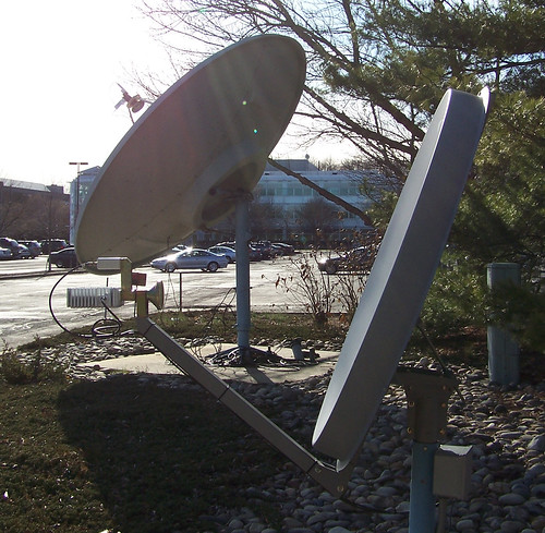
Last month, it was one and one and one is "no go:" the FCC dismissed (PDF) an application from the City of Chicago’s Office of Emergency Communications to operate a small satellite communications network consisting of a hub and two remote VSAT stations using sub-one-meter antennas. Besides not including a radiation hazard study, which is standard for earth station applications, the FCC found other details lacking:

Section 25.220(e)(1) of the Commission’s rules, 47 C.F.R. § 25.220(a)(1), requires applicants proposing non-routine earth stations to include with the application a certification from each target satellite operator that the target operator has reached agreements with adjacent satellite operators regarding the non-routine operations.

Chicago also wanted to be able to connect with any available satellite over the U.S. during an actual emergency. I’m sure they’ll refile their application, but they should probably consider using a pre-engineered, commercially-licensed emergency communications system such as REDiSat — which uses a the AMC-6 satellite’s Ku-band payload (which is actually pretty hot over Chicago) to connect to a fully-licensed earth station in Maryland. It uses an antenna that’s approved for two-way communications anywhere in the lower 48, typically a 1.2m Patriot antenna and an iDirect modem.

Los Angeles County installed an extensive VSAT network years ago, as did the State of Florida. But these are "hot spots" for these types of networks and they went to great lengths in designing and installing them. Other large cities have done likewise since 9/11. With simpler configurations such as the type REDiSat offers, smaller municipalities can now begin considering a communications network that uses the ultimate diverse path: through space.

Hey, it worked in Biloxi.

Space Video: On-orbit Servicing with NextSat

Tuesday, April 3rd, 2007

We told you about the launch a few weeks back, but the Orbital Express refueling system appears to be up, running, and pretty effective. For those that don’t remember here’s the story about the new technology:

The goal of the Orbital Express Space Operations Architecture program is to validate the technical feasibility of robotic, autonomous on-orbit refueling and reconfiguration of satellites to support a broad range of future U.S. national security and commercial space programs. Refueling satellites will enable frequent maneuver to improve coverage, change arrival times to counter denial and deception and improve survivability, as well as extend satellite lifetime. Electronics upgrades on-orbit can provide regular performance improvements and dramatically reduce the time to deploy new technology on-orbit.

The full story about the mission of the Orbital Express satellite can be found at NASA’s Automated Rendezvous & Docking program website.

The video you see about you is a survey of the NextSat, the kind of serviceable satellite the Orbital Express is designed to fuel, and its refueling buddy as taken by the camera on its own arm.

DIY Friday: Satellite Radio Round-Up

Friday, March 30th, 2007

We tend to write a lot about Satellite Radio here on DIY Fridays, but that’s probably because it represents the next frontier for true satellite geeks. Digital quality audio, anywhere in the country, in your home or on the road, satellite radio represents a dream come true for nerdy enthusiasts: technical superiority, freedom, and a new chance to tinker with technology. So while, its not a purely DIY task, I thought I might use this week’s DIY Friday to talk a little bit about our new favorite technology.

First of all, for those who admit that they need to learn a little bit more about satellite radio technology, this article by the folks over at Crutchfield Advisor explains the reality of the satellite radio marketplace and the options out there for those looking to tune in in an incredibly readable way. While normally I’d be a little concerned about passing along a guide about a product from a company that looks to sell you something (especially on a DIY Friday), Crutchfield is famous for being a dream company for DIYers looking to add new and improved audio technology to their car. Not only does every install kit from Crutchfield come with thorough, user-friendly instructions, but the company’s sales and help lines are famous for their knowledgeable, no pressure operators most of whom are willing to talk you through almost any car stereo installation troubles you can imagine.

But what about those times that you’re not in your car or near an otherwise wonderful satellite radio receiver. Well, have no fear, an amazingly productive community of open source developers is here to bail you out of radio-less existence. According to WIRED, developers have rolled their own solution to the problem of no satellite signal =ing no radio with Pocket Satellite Radio and Mobile Satellite Radio which are able to grab the streams using a cell phone’s internet connection. While it means you might be limited to whatever stations Sirius or XM stream over the net (which means no Howard for dedicated Stern-ites), it does give you access to most stations when your in a dire situation (read: without a satellite signal). The best part? It’s a receiver for only $20.

Nortel, MSV to build Hybrid Satellite-Terrestrial Network

Thursday, March 29th, 2007

We’ve seen the future, and it contains uninterrupted service.

Mobile Satellite Ventures (MSV) and Nortel this week announced that they are partnering to deploy the first integrated 4G and satellite broadband network:

"This trial is a significant step toward next-generation mobility," said Drew Caplan, MSV chief network officer. "Nortel’s 4G and IMS expertise will help us demonstrate our transparency network architecture to support hybrid satellite-terrestrial communications on the basis of a 4G broadband platform, enabling new dimensions of service for our customers."

The trial with Nortel, which will be conducted in the Reston, Virginia area, will initially feature high-speed wireless voice, data and Web access, file sharing, and VoIP connectivity using residential gateway devices and PC Cards for users in fixed and portable modes of use. Subsequently, MSV expects to incorporate push-to-talk, video calling, picture-caller ID, and presence capabilities, full MSS/ATC integration, and support for a range of mobile devices. Nortel will integrate its WiMAX and IMS connectivity as well as devices and ASIC technology from Kyocera, WiNetworks, and Runcom Technologies.

The Ottawa Business Journal also has coverage of the joint venture, which was announced this week at the CTIA Wireless 2007 Conference in Orlando, Florida. (Some other interesting and hip tidbits from CTIA: Nokia had one of the cooler displays, and AT&T’s COO was spotted with an iPhone.)

Although MSV  was the first company to get an Ancillary Terrestrial Component license from the FCC, which provides the legal permit for the hybrid system, they’re certainly not the only company pursuing the promise of a network that combines the best of tower and satellite mobile communications. TerreStar Networks is building "North America’s first all-IP enabled, next generation mobile communications network over an integrated satellite-terrestrial system" that "will provide universal access and tailored applications to millions of users throughout North America via mass market commercial wireless devices." Low-Earth Orbit satcom company LeoTerra is also involved.

Whichever company gets there first with a hybrid system, however, the 4G broadband marketplace is likely to be tumultous in the coming years, as we wrote earlier this month. In January of 2008, the FCC will be auctioning off "the last beachfront-property" spectrum in the nation — the 60 megahertz spectrum being vacated by television broadcasters when they cease analog broadcasting in 2009 — and there are some big names — including Yahoo! and Google — that are lobbying the FCC to allow bidders to aggregate enough licenses to create new national 4G networks.

It truly is a brave new world.

Look out below!!!

Wednesday, March 28th, 2007


Flaming space junk from a Russian satellite narrowly missed hitting a Chilean airliner over the Pacific Ocean, reports said Wednesday.

The pilot of a LAN Chile Airbus A340 en route to New Zealand told air traffic controllers he had seen pieces of flaming space junk falling about eight kilometres (four miles) in front of the plane and behind it, TV3 said.

The aircraft was not struck by any of the debris and later landed safely in Auckland.

Airways New Zealand, which manages New Zealand’s air traffic, said it had been warned by Russian authorities that an obsolete satellite was due to fall into the Pacific Ocean on Wednesday.

But the debris had apparently fallen into the area 12 hours earlier than the time advised by the Russians.

A spokesman for the Civil Aviation Authority, which is responsible for air safety, said it would launch an inquiry after it was advised of the details of the incident.

Hu, Putin Orbit Around Mars

Tuesday, March 27th, 2007


We blogged about the Chinese-Russian mission to Mars last August, so this isn’t really news to us. But during Chinese President Hu Jintao’s visit to Russia the other day, a formal announcement was made about a mission to Phobos, a Martian moon. Here’s the story from People’s Daily:

A Chinese satellite is expected to orbit Mars in 2009, thanks to an agreement the country signed with Russia on Monday

During President Hu Jintao’s current visit to Moscow, the two countries agreed to stage a joint unmanned mission to the red planet and one of its moons in two years, the China National Space Administration said yesterday in Beijing.

The agreement represents a "milestone" in the history of space cooperation between the two neighbors, the agency said in a statement.

"It indicates the two sides have taken a key step forward to working together on a large space program."

According to the agreement, a micro-satellite developed by China will be launched along with "Phobos Explorer", the Russia spacecraft, atop a Russian rocket in 2009.

A timetable was not mentioned, but earlier Russian reports said the launch window for the 10-11 month voyage to Phobos, a Martian moon, will be October 2009.

Phobos became a satellite of Mars millions of years ago, so studying material from the asteroid will give scientists information on the origins of the solar system and of Earth, the Russian news agency RIA Novosti cited Russian Academy of Sciences member Mikhail Marov as saying.

After entering Mars’ orbit, the Chinese micro-satellite will be detached from the Russian spacecraft, and probe the Martian space environment, according to the statement.

The "Phobos Explorer" spacecraft, with some equipment developed by the Hong Kong Polytechnic University, will land on the Martian moon and return to Earth with soil samples.

Monday’s agreement was signed by the China National Space Administration head Sun Laiyan and the Russian Federal Space Agency chief Anatoly Perminov and witnessed by the two countries’ presidents.

Last year, the Russian space chief revealed that his country would work "closely" with China on lunar exploration.

Youriy Nosenko, deputy chief of the Russian space agency, told a press conference in Beijing last November that Russia regards China as a "partner" in space exploration, and the two sides have shown interest in a lunar project.

China has started a three-stage moon exploration project, including sending a lunar orbiter some time this year, followed by a soft landing in 2012 and the return of lunar samples in another five years.


Unlike NASA, a civilian agency,  the China National Space Administration falls under the supervision of the Commission of Science Technology and Industry for National Defence. But hey, the Taikonauts have their fans.


These Old Eyes Need New Glasses

Tuesday, March 20th, 2007

An aging satellite that has been in operation for seven years but was expected to last for only five is putting America’s hurricane forecasting ability at risk, according to a story from the Associated Press.


The QuickSCAT satellite "conducts daily surveys of 90 percent of the ice-free oceans, using a so-called radar scatterometer to measure surface wind speed and direction."

The resulting images are not only visually compelling — they provide scientists with fresh information about our planet’s weather patterns.

(For example, this set of images helped scientists understand that the Santa Ana winds that dry out coastal and interior regions of California and help fan the flames of wildfires produce a previously unknown benefit to the region’s fisheries.)

But the cause celebre of QuickSCAT are images like the one above, showing the wind speeds of Hurricane Dora back in 1999.

But scientists may have to attempt hurricane forecasts without the aid of QuickSCAT, according to the AP report:

Certain hurricane forecasts could be up to 16 percent less accurate if a key weather satellite that is already beyond its expected lifespan fails, the National Hurricane Center’s new director said Friday in calling for hundreds of millions of dollars in new funding for expanded research and predictions….

One of Proenza’s immediate concerns is the so-called "QuikScat" weather satellite, which lets forecasters measure basics such as wind speed. Replacing it would take at least four years even if the estimated $400 million cost were available immediately, he said.

It’s in its seventh year of operation and was expected to last five, Proenza said, and it’s only a matter of time until it fails.

Without the satellite providing key data, Proenza said, two- and three-day forecasts of a storm’s path would be affected. The two-day forecast could be 10 percent worse, while the three-day one could be affected up to 16 percent, Proenza said.

That would mean longer stretches of coastline would have to be placed under warnings, and more people than necessary would have to evacuate, he said.

We’ll keep you updated (as we always do) on efforts to replace QuickSCAT and other observation satellites that help bring people the accurate forecasts (we’re not joking here!) that they’ve come to expect.

A Boatload of Bandwidth

Thursday, March 15th, 2007

Have you ever contracted the annoying song virus?

You know, you’re minding your own business in the office when someone says to you, "I can’t get this annoying song out of my head."

And proceeds to tell you what is is — or sings it. 

And then you’ve got that thing stuck in your head for the rest of the day?

Well we contracted that virus via the Internet this morning when we saw the photo to the left.

We’ll let you guess the song (we won’t be cruel), but what the heck is that a photo of? 

It’s the Zeeman Ocean Challenge, an attempt to do what no one has ever done before: row across the Pacific Ocean at its widest point with no support at all. (9 people have done it with support.)

That’s 16,000 kilometers, and a pretty amazing thing to attempt. But what really caught our eye was the white umbrella on the stern deck.

We’ve written before about the use of satellite communications to keep in touch on maritime adventures (such as when the Kon-Tiki sailed again). It’s worth taking a moment to look at the marketplace again.

How does one stay in touch while in the middle of the ocean?

First, one needs a good maritime satellite antenna — such as this new C2SAT antenna. Then, if you’re not going to subscribe to Direct to Sailor TV, you’ll need to subscribe to a service for phone and internet connections.

So you can surf while you drift, as it were.

Eutelsat offers always on net capability, whether you’re in a rowboat or something bigger or something bigger still. Their maritime service is available on their W3A satellite (7 East), which is good for the Mediterranean and coastal Europe as well as coastal sub-Saharan Africa, or on Atlantic Bird 1 (12.5 West), which covers the Western European coast, North Sea, and the coastal waters off eastern North America.

But the "King of the Hill" in maritime communications is Inmarsat, which provides flexible pricing plans for the little guy in the rowboat but also the bandwidth to broadcast a rare Marathon in Antarctica.

Now if we could just get that song out of our head.

Facing the Next Katrina with Satellite

Monday, March 12th, 2007

Nearly five and a half years after September 11 and eighteen months since Katrina, the U.S. Department of Homeland Security and many of the country’s public safety agencies and organizations have yet to solve the problem of interoperatable communications. While this might seem pretty nerdy, its the lack of communication system cross compatibility that prevented firefighters from hearing police calls to escape the WTC when its exterior began crumbling and ultimately limited the execution of a full-scale evacuation of the Gulf Region in August 2005.

Fortunately, the U.S. Congress is finally starting to make some headway, albeit after Former DHS head Tom Ridge slammed the government for failing to deal with the problem. In addition to pushing legislation that would modernize the 911 system throughout the country (particularly in rural areas), the Senate recently approved Interoperable Emergency Communications Act (S.385), which according to Senator Ted Stevens (R-Alaska)’s website,

"provides the National Telecommunications and Information Administration (NTIA) with more guidance as it awards $1 billion in interoperable emergency communications grants to police, firemen, and emergency medical personnel… This bill would allow up to $100 million of the expedited $1 billion to be used to establish technology reserves that would assist emergency response agencies in pre-positioning communications equipment in state or regional facilities. These reserves can be activated quickly in the event of a major emergency or natural disaster"

While this has led to Nextel co-founder Morgan O’Brien to suggest (and for Fmr. Sec. Ridge to support) the creation of a national broadband public safety network using "a slice of spectrum in the 700 MHz band that is scheduled for auction in 2008," there is another more immediate and potentially less costly option… satellite. As Satellite Industry Association (SIA) Executive Director David Cavossa recently pointed out in a press release,

"Hurricane Katrina and other recent disasters have shown, satellite communications are uniquely able to provide resilient, redundant, and ubiquitous communications when all other terrestrial-based communications fail."

While its probably not the only solution, it seems that Katrina probably taught us that satellite technology should be included in any robust, interoperatable emergency communication systems solution. Working together with standard radio-based wireless technologies, options built on technology similar to SES-Americom’s REDiSat Network might be just the ticket.

Insat 4B and Skynet 5A Launched by Ariane 5

Sunday, March 11th, 2007

The news from Arianespace

Coup double pour Arianespace / Mission réussie pour Skynet 5A et Insat 4B

Dans la nuit du dimanche 11  au lundi 12 mars 2007, Arianespace a mis en orbite de transfert géostationnaire deux charges utiles : le satellite de télécommunications militaires Skynet 5A pour le Ministère britannique de la Défense (MoD) et le satellite de télécommunications civiles Insat 4B pour l’Agence Spatiale Indienne (ISRO).

Trente-et-unième lancement d’Ariane 5, dix-septième succès d’affilée.


Sounds a lot better than the English translation:

Arianespace begins its 2007 mission activity with a successful dual-payload launch

Ariane 5 underscored its mission capability and operational maturity with tonight’s successful dual-passenger mission, which placed the Skynet 5A and INSAT 4B satellites into geostationary transfer orbit.

The March 11 mission was Ariane 5’s 31st liftoff from the Spaceport and the launch vehicle’s 17th consecutive success.

Lifting off from the Spaceport in French Guiana, the Ariane 5 deployed Skynet 5A at 26 minutes into the mission, followed four minutes later by INSAT 4B.

"With this first launch of the year 2007, Arianespace has once again demonstrated its leadership," said CEO Jean-Yves Le Gall. "The satisfaction of every customer is our keyword, offering the best possible Service & Solutions to each one."