Archive for the ‘Satellites’ Category

Using Satellites to Study Whales

Wednesday, October 10th, 2007

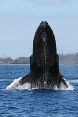
For decades, Japan’s scientific whaling program has killed thousands of whales as part of what it calls necessary research.

Needless to say, Japan’s whaling program has been a point of contention with the environmental group Greenpeace for just as long.

Now, however, Greenpeace is leading the fight against whaling a different way — by example:

Greenpeace announced a satellite-based tracking system to monitor endangered South Pacific humpback whales, saying it is not necessary to kill the animals as Japan does to study them…

Humpback whales from Rarotonga and New Caledonia have been satellite tagged and are "now being tracked in order to produce vital data on their movements, habitat use and population structure," said Greenpeace New Zealand’s oceans campaigner, Mike Hagler.

"The tagging program is producing real scientific results" on whale migrations from breeding grounds in the South Pacific to feeding grounds of the Southern Ocean "without firing a single harpoon," he said.

Tracking whale migration is critical to developing plans and policies to preserve the species; satellite tracking is a natural solution to the problem of tracking big mammals in an even bigger ocean. Whalenet has a good description of how satellite tracking works for whales:

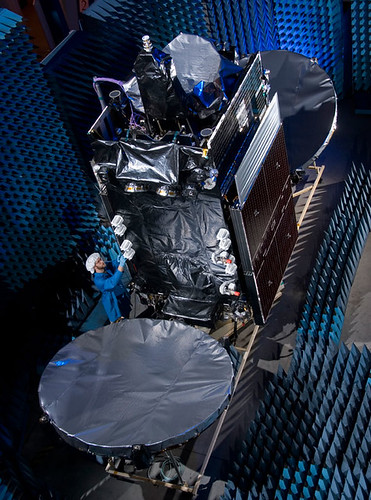
  WhaleNet uses satellite transmitters that send signals to satellites maintained by the ARGOS System in Largo, Maryland and Talouse, France. A number of the U.S. National Oceanographic and Atmospheric Administration’s (NOAA) weather satellites, circling the earth, have ARGOS instruments attached. These instruments collect, process and disseminate environmental data relayed from fixed and mobile transmitters worldwide. What makes ARGOS’s system unique is the ability to geographically locate the source of the data anywhere on the Earth.

Data is collected by the tag while the marine animal is underwater and then transmitted when the animal surfaces. The tag has an antennae which is used to send a signal each time the animal surfaces. Information relayed includes time, date, latitude, longitude, dive depths, dive durations, amount of time at the surface in the last six hours and quality of the transmission. The ARGOS instruments detect the tag’s signal when the satellite passes overhead.

The location fix of the animal in relationship to the track of the satellites, with ARGOS instruments, affects how many satellites passes are made over the animal’s tag in a 24 hour period. Each pass may last between 2 and 12 minutes, depending on the location of the satellite in relation to the animal. The animal must be at the surface at the time of the pass for a successful transmission to take place. Therefore, each day there are a limited number of short opportunities, or maybe no opportunities, for a signal to be transmitted from an animal’s tag to a satellite.

How are they attached?

 With whales the tag is attached by partially implanting a barb into the blubber layer at a slight angle, to a depth of approximately 10 cm. Ideally it is placed high on the back of the whale, directly behind the blow hole. These tags are deployed using a compound crossbow. A study by the Minerals Management Society determined that this does not cause serious stress or pose a health risk to the whale. The tagging team goes out in a 4 meter rigid-hull inflatable equipped with an outboard motor in order to get close enough to the whale to implant the tag.

There’s no relation, we hear, between the satellite tracking of whales and the chip implants for your pet.


Upcoming Launches

Tuesday, October 9th, 2007


Taking a look (and translating) the Proton launch manifest, we see that the Sirius 4 satellite (pictured above) is set to lift later this month, pending review of the causes behind the launch failure of the JCSAT 11 satellite from Baikonur:

SIRIUS 4 is a multi-mission Ku/Ka-band satellite. It is built on Lockheed Martin’s reliable A2100AX platform. SIRIUS 4 will be deployed at orbital position 5 degrees East.

SIRIUS 4 will be the biggest satellite and a welcome addition to the SIRIUS satellite fleet. The satellite is intended to meet today’s growing demands and tomorrow’s new challenges. SIRIUS 4 will enhance capacity and widen the coverage of Eastern Europe.

Following Sirius 4 on successive Proton launches will be Telenor’s THOR 5 bird, which has 24 transponders with three times more payload power compared to the current THOR II  satellite that it replaces, as well as the AMERICOM-14 satellite.

Sirius is in competition with Telenor for not only the Scandinavian market (where the Thor 5 delay may be impacting the introduction of a new children’s channel, NRK Super) but for Central and Eastern Europe as well.

But Telenor is expanding. They just ordered Thor 6, which will launch aboard Ariane, about six months ago from Thales Alenia Space

THOR 6 will be based on Thales Alenia Space Spacebus 4000B2 platform and fitted with 36 active Ku-band transponders. 16 transponders will point to the Nordic countries, and 20 transponders will be positioned to serve the growing broadcasting demands within Central and Eastern Europe. With the launch of THOR 6, the 1° West will have a total of 71 transponders providing capacity to facilitate both organic growth and expansion for Telenor.

Already, Intelsat has ordered 10 transponders on the THOR 6 bird.

Telenor is also in the phone business, of course, and does business all over the world. In Asia, they’ve experienced some rough patches of late.

Dishes Galore in Tahoe! (And Reno, Too!)

Monday, October 8th, 2007

Call it serendipity: as members of the satellite industry prepare to attend the Satellite and Broadcast Expo West  in Reno at the end of this week, the Tahoe Daily Tribune observes that there are a heck of a lot of dishes in the area:

More and more, satellite dishes are becoming a fixture in the South Shore scenery, in a sign that satellite providers may be gaining ground in the battle for pay-TV subscribers.

Although cable and satellite providers are shy about revealing raw data concerning subscribers, it seems that satellite TV is becoming the choice of more South Shore residents.

Frank Giardina, owner of Frank’s TV and Electronics on Lake Tahoe Boulevard, estimates that he has installed 1,600 satellites dishes in the area. Frank’s serves as an independent contractor for Dish Network, making them the only "local" satellite provider in the area.

SBE West has a number of great special events at the show. We’re particularly intrigued by the John Hack Technician Challenge:

 Imagine digging through a bucket full of change, connectors, bolts and washers just trying to find enough money to buy $5.00 worth of gas to get to your first install of the day!  That task and more is what contestants in the John HackTechnician Challenge will be facing at SBE 2007 in Reno. Consider it a fun and exciting, timed obstacle course for satellite technicians.   How long would it take you to put 50 pages of work orders in the correct sequence for faxing at the end of the week? We will know at the end of the Technicians challenge.

We think John Hack is a great name for a technician. For those unfamiliar with "him," he started as a column in Transmitter News. You can find his full bio and news about his exciting projects here.

Soyuz Liftoff to Make Double History

Monday, October 8th, 2007


The liftoff of the Soyuz-FG rocket from the Baikonur cosmodrome in Kazakhstan later this week is set to make history — twice.

On board will be Malaysia’s first astronaut and an American who will become the first woman to command the international space station.

The AP reports: 

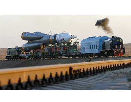
The Soyuz-FG rocket is scheduled to blast off from the Central Asian steppe on Wednesday night to take Malaysia’s Sheikh Muszaphar Shukor, Peggy Whitson of Beaconsfield, Iowa, and Russian Yuri Malenchenko into orbit.

During his 12-day space trip, Shukor is to study of the effects of microgravity and space radiation on cells and microbes, as well as experiments with proteins for a potential HIV vaccine.

The rocket — adorned with a Malaysian flag and coat of arms and carrying a Soyuz TMA-11 spacecraft — was moved Monday to the launch pad from its assembly site at the Baikonur cosmodrome, which Russia rents from Kazakhstan.

"It’s too exciting to be cold," said Shankini Dovaisingam, a Malaysian aerospace engineer observing the final preparations. "It’s amazing to see the Malaysian flag on a Soyuz spaceship."

The mission coincides with the last days of Ramadan, the holy month when Muslims fast from dawn until sundown, but Malaysian clerics decreed that Shukor will be excused from fasting while in space.

We wrote about how Shukor will adhere (or be excused) from his religious customs here

Also be sure to check out the AP slideshow on the left of this page for more photos of the rocket rollout and the security at Baikonur. 

Double-Header Launch for Orbital

Thursday, October 4th, 2007


They’ll be up early in Sydney, Australia, on Saturday morning, watching a rocket launch their new satellite — and the same goes for Intelsat in Pembroke, Bermuda, too.

For the past few weeks, Orbital Sciences has been very busy at Europe’s Spaceport in Kourou preparing for their "double-header:" they built both "passengers" set to be carried by Arianespace. Looks like a "go" for an Ariane 5 (GS configuration) launching Optus D2 and Intelsat 11 on Friday, 5 October 2007:

Arianespace’s fourth mission of 2007 is set for Friday, October 5, with the green light given today after the launch readiness review at Europe’s Spaceport.

This review, which is held before every Ariane flight, verifies the readiness of the Ariane 5 vehicle, its two payloads, the launch infrastructure at the Spaceport in French Guiana, and the downrange network of tracking stations.

The upcoming mission will orbit two medium-sized satellites built by the same U.S. manufacturer, Virginia-based Orbital Sciences Corporation, for Intelsat and Optus.

The Intelsat 11 spacecraft is riding in Ariane 5’s upper payload position, and is to be released first in the mission sequence. To be operated by Washington, D.C.-headquartered Intelsat, the satellite will host Latin America’s premiere video programmers and the region’s largest DTH (direct-to-home) platform. Intelsat 11 is based on the Orbital Sciences STAR 2 spacecraft bus, and carries a hybrid payload composed of 16 C-band and 18 Ku-band transponders. The satellite weighs approximately 2,500 kg. at launch.

Optus D2 also uses an Orbital Sciences STAR 2 bus, and is to be operated by Australian-based Optus to enable the development of new business opportunities for the direct-to-home market, new data services and services bundling. Positioned at an orbital slot of 152 deg. East, the 2,350-kg.

45-minute launch window opening, by city:

  • GMT: 21:28 on 5 OCT 2007
  • Luxembourg: 23:28 on 5 OCT 2007
  • New York: 17:28 on 5 OCT 2007
  • Kourou, French Guiana (local time): 18:28 on 5 OCT 2007
  • Sydney: 07:28 on 6 OCT 2007

Watch the live Webcast here.

Here’s Intelsat 11 being tested…

Antarctic Connection by Optus

Wednesday, October 3rd, 2007


The U.S. Antarctic Program, administered by the National Science Foundation, will be using Australia’s Optus D1 satellite to keep their facilities around McMurdo Sound connected, using the earth station on Black Island, by becoming part of the National Polar-orbiting Operational Environmental Satellite System (NPOESS) network

NPOESS will use polar-orbiting satellites to observe Earth from space. The satellites will collect and disseminate data on Earth’s weather, atmosphere, oceans, land, and near-space environment. The polar orbiting satellites are able to monitor the entire planet and will bring improved data and imagery that will allow better weather forecasts, severe-weather monitoring and detection of climate change.

The raw data collected by the NPOESS satellites is then modelled at the U.S. based weather data centres and distributed to a global user population which includes bodies such as bureaus of meteorology.

The National Science Foundation (NSF) manages and funds the U.S. Antarctic Program (USAP), which coordinates all U.S. research on the southernmost continent. McMurdo is one of three year-round stations NSF maintains in Antarctica, the others being Amundsen-Scott, at the geographic South Pole, and Palmer, on the Antarctic Peninsula. The National Science Foundation and NPOESS are jointly collaborating on the development of McMurdo as one of the NPOESS weather downlink stations and intend to share the satellite service provided by Optus.

Optus has been working closely with Raytheon Company in the provision of the SafetyNet™ system which is a network linking 15 satellite antennas to the weather data centres. Data collected by the NPOESS satellites is capable of being downloaded to any of the receptor sites installed at key locations around the globe. Each of the sites, with the exception of McMurdo Station, is connected via a fibre cable network to the system data centres. The data collected in McMurdo will be transferred via the Optus D1 satellite to the fibre network in Sydney, Australia.

"We believe the D1 satellite coverage will make a real difference to the McMurdo Sound facility. Optus Satellite will be delivering a unique communications solution to meet our customers’ specific requirements. It also further cements our position as the premium supplier of satellite services in our chosen markets," said Mr. Sheridan.

The NSF Black Island satellite earth station facility, located 20 km distant from McMurdo on a desolate, wind-swept island, will establish the link with Optus D1. In addition to supporting NPOESS data transmissions, NSF will more than triple its current data communications capability for the USAP, a significant benefit to the science research program, as well as to the health and safety of more than a thousand people.

Optus D1 was the satellite launched last year that developed problems during in-orbit testing and it’s home to lots of interesting programming, such as Maori TV. Optus D2, incidently, is set to launch on Friday (5 October 2007) via Arianespace. More on that tomorrow.

Got to admire the people who spend up to six months at McMurdo — it’s like another planet.

Very cool film by Antzartica on YouTube:

Time-lapse video filmed in Antarctica, in and around McMurdo Station and Scott Base.

Each year the sun is below the horizon for 4 months in the middle of winter, and above the horizon for 4 months in summer. During the couple of months in between we have more-or-less normal days.

Includes shots of auroras and the very rare polar stratospheric nacreous clouds, which form when ozone depleting gases crystallize in the upper atmosphere in the intense cold.

Summer population is about 1200 people, winter about 200.

This is just a small sample of an ongoing project to collect time-lapse imagery of Antarctica. I have taken over 1,000,000 individual photos and worn out a number of cameras that make up the collection of footage I have gathered so far over the last 5 years.

Satellite Images Confirm Human Rights Abuses in Myanmar

Tuesday, October 2nd, 2007

The brutal crackdown of nationwide protests in in Myanmar last week has led to strong international condemnation of the military junta in Burma, while images and video of Burmese soldiers attacking Buddhist monks, who led many of the demonstrations that grew to as many as 100,000 before the crackdown began, have gripped the world media.

But the public dispersions of the protests haven’t been the junta’s only violent attempts to crack down on dissent. A new analysis of high-resolution satellite images completed by the American Association for the Advancement of Science (AAAS) "pinpoints evidence consistent with village destruction, forced relocations, and a growing military presence at 25 sites across eastern Burma where eyewitnesses have reported human rights violations," according to the AAAS website:

The research by AAAS, a non-profit, non-partisan organization and the world’s largest general scientific society, offers clear physical evidence to corroborate on-the-ground accounts of specific instances of destruction. It is believed to be the first demonstration of satellite image analysis to document human rights violations in Burma, also known as Myanmar.


AFP has additional details:

Patches of scorched earth corresponding to settlements reportedly destroyed are visible in the high-definition photographs taken by satellites zooming in on the secretive state in late April and analyzed by the Washington-based American Association for the Advancement of Science (AAAS).

Now the group has trained the satellites on Myanmar’s main cities to try and peer through the clouds and see military deployments amid the current unrest, as the crackdown on pro-democracy protests led by monks has turned bloody.

In Karen areas of eastern Myanmar, the group used three commercial satellites to focus on 31 "attack sites" of reported rights violations from mid-2006 to early 2007, AAAS project director Lars Bromley told reporters Friday.

In one picture, a satellite spotted foundations and fence lines with all the structures gone, where a village had stood two years earlier.

The area photographed was the site of a reported military raid on April 22, on Karen villagers accused by the regime of supporting armed rebels. Bromley estimated a dozen people were killed there and the rest fled.

The image on the left, above, shows a settlement adjacent to rice paddies in 2000. The image on the right shows the same area in December 2006. This area was reported attacked in April 2006. Check out this ABC News slideshow for additional photos from AAAS.

“Yes!” For YES2 Mission

Thursday, September 27th, 2007


The second Young Engineers Satellite (YES2), involving nearly 500 university students from Australia, Japan, Europe and North America, launched on 14 September 2007 and came down safely in Kazakhstan on the 26th. The ESA’s Education Office is calling the mission a success:

The reentry capsule for the Foton-M3 spacecraft, which has been in low-Earth orbit for the last 12 days, successfully landed this morning in an uninhabited area 150 km south of the town of Kustanay in Kazakhstan, close to the Russian border, at 09:58 CEST, 13:58 local time.
 
The unmanned Foton spacecraft, which was launched on 14 September from Baikonur Cosmodrome, in Kazakhstan, carried a payload of 43 European experiments in a range of scientific disciplines – including fluid physics, biology, crystal growth, radiation exposure and exobiology.

The mission was intensively monitored throughout by 65 engineers and scientists located at ground stations at Esrange, in Kiruna, Sweden, and at the Russian flight control centre, TsUP, in Moscow, Russia. Thanks to a close cooperation with the Canadian Space Agency, ground stations in St. Hubert and Saskatoon were also used to receive data from the spacecraft. 
 
“I am extremely pleased with the success of the Foton-M3 mission,” says Josef Winter, Head of ESA’s Payload and Microgravity Platform Division. “All operations during the mission were flawless. The hard work and dedication of all involved has contributed to make this mission a success. I would like to congratulate our Russian counterparts and thank them for their outstanding cooperation.”

Helicopters were immediately at the landing site to start recovery operations, including the retrieval of experiment hardware. The European experiments will now be returned to the labs at ESA’s research and technology centre, ESTEC, in Noordwijk, the Netherlands, tomorrow evening. After further inspection at ESTEC the experiments will be returned to the scientific institutions where the data will be analysed over the coming months.
 
Only in-depth analysis will reveal the full extent of the scientific return of the mission, although data received during the flight already shows promising results – the Italian and US team responsible for the GRADFLEX (GRADient-Driven Fluctuation EXperiment) experiment received preliminary confirmation of a 10-year-old fluid science theory.

A further highlight of the mission was yesterday’s deployment of a small reentry capsule from the outside of the Foton spacecraft. The Second Young Engineers’ Satellite (YES2) experiment saw the release of the beachball-sized Fotino capsule from the end of a tether to demonstrate the smart possibility of returning small payloads to Earth.

"I am extremely satisfied that we could fly a very high number of experiments during the Foton-M3 mission and that they all worked out well. Some of them will even be further elaborated onboard the International Space Station," says Martin Zell, ESA’s Head of Research Operations for the Directorate of Human Spaceflight, Microgravity and Exploration.

 The experiment was some coverage in the almost-science press this week. Wired, for example:

The students’ critical moment came today, and so far it’s a qualified success. The payload, a small capsule dubbed “Fotino” was intended to be let out on a 18.6 mile, fishing line-thin tether before being released. But the process went more slowly than projected, and the little test capsule was cut loose by a preprogrammed command after just 5.2 miles.

European Space Agency scientists are currently tracking the little device to figure out where and how its parachute will bring it back to earth.

The mishaps may mean that the students’ tether system won’t find its way immediately into adoption for critical satellite or other launches. But the test gives space programs around the world new data on an innovative and potentially money-saving technique for orbital deployments.

They’re right about how cool this mission was. Here’s their animation:


Still no word on whether the prog-rock group Yes is comtemplating a copyright infringement complaint.

Next stop: the asteroid belt

Wednesday, September 26th, 2007

We’re one day until launch. NASA’s newest mission, a 3-billion mile, 8-year journey, will explore the asteroid-belt. The mission’s chief engineer, Marc Rayman, sure knows how to build the excitement: "In my view, we’re going to be visiting some of the last unexplored worlds in the inner solar system."

"Dawn" will, appropriately, launch just after sunrise tomorrow morning. That is, if the forecast of rain holds off.

USA Today has the mission details:

Dawn will travel to the two biggest bodies in the asteroid belt between Mars and Jupiter — rocky Vesta and icy Ceres from the planet-forming period of the solar system.

Ceres is so big — as wide as Texas — that it’s been reclassified a dwarf planet. The spacecraft will spend a year orbiting Vesta, about the length of Arizona, from 2011 to 2012, then fly to Ceres and circle there in 2015.

Dawn’s three science instruments — a camera, infrared spectrometer, and gamma ray and neutron detector — will explore Vesta and Ceres from varying altitudes.

[…]

Because Vesta and Ceres are so different, researchers want to compare their evolutionary paths.

No one has ever attempted before to send a spacecraft to two celestial bodies and orbit both of them. It’s possible now because of the revolutionary ion engines that will propel Dawn through the cosmos.

Dawn is equipped with three ion-propulsion thrusters. Xenon gas will be bombarded with electrons, and the resulting ions will be accelerated out into space, gently shoving the spacecraft forward at increasingly higher speeds.

"It really does emit this cool blue glow like in the science fiction movies," Rayman said.

NASA tested an ion engine aboard its Deep Space 1 craft, which was launched in 1998. Ion engines have been used on only about five dozen spacecraft, mostly commercial satellites.

Dawn also has two massive solar wings, nearly 65 feet from tip to tip, to generate power as it ventures farther from the sun. Ceres is about three times farther from the sun than Earth.

You can watch the launch live on NASA TV — available on web stream. The "pregame show" begins at 5:15am. The main event will begin sometime between 7:20am and 7:49am:

Dawn’s Sept. 27 launch window is 7:20 to 7:49 a.m. Eastern Daylight Time (4:20 to 4:49 a.m. Pacific Daylight Time). At the moment of liftoff, the Delta II’s first-stage main engine along with six of its nine solid-fuel boosters will ignite. The remaining three solids are ignited in flight following the burnout of the first six. The first-stage main engine will burn for 4.4 minutes. The second stage will deposit Dawn in a 185-kilometer-high (100-nautical-mile) circular parking orbit in just under nine minutes. At about 56 minutes after launch, the rocket’s third and final stage will ignite for approximately 87 seconds. When the third stage burns out, actuators and push-off springs on the launch vehicle will separate the spacecraft from the third stage.

WiMAX is Easy as ABC

Friday, September 21st, 2007


We’ve been writing about "wifi on steroids" — or WiMAX — since the earliest days of the Really Rocket Science blog, when it was but a dream on the technological horizon.

These days, understanding the deployment and growth of WiMAX  is as easy as A-B-C.

A is for Alaska, where AT&T Alascom, which has been using satellites to deliver telecom across Alaska since 1974, is rolling out WiMAX using  Alvarion Ltd.’s BreezeMAX 2.3 GHz TDD equipment:

 Alvarion’s solution is capable of delivering flexible and enhanced coverage even in difficult terrain, such as the hilly and wooded areas. In addition, Alvarion’s nomadic self-install Si CPE can incorporate a patent-pending fast-switching algorithm with six integrated antennas. The Si can is available with a wide variety of options, from multiple POTS interfaces to built-in Wi-Fi.

To deliver WiMAX, AT&T Alascom utilizes SES-Americom’s AMC-8 satellite (also known as Aurora III) exclusively.

Rumors also have AT&T deploying WiMAX in the South soon:

AT&T Inc. is preparing to launch WiMax services during the second quarter of 2008, Unstrung has learned from an industry source. The services will likely be in the South of the U.S. where the operator has suitable licenses for broadband wireless services.

The cellular giant is planning to deploy limited WiMax services in the 2.3 GHz band that could be used as a fixed-wireless alternative to DSL or cable offerings, the source says. AT&T is said to have its suppliers for the service lined up now.


B is for Breezemax; Alvarion of Israel is making real progress in selling their BreezeMAX system for WiMAX apps:


Commercially available since mid 2004, deployed by over 150 operators in more than 30 countries, BreezeMAX is the most advanced, field proven commercial WiMAX solution and the first to offer CPE powered with Intel PRO/Wireless 5116 broadband interface WiMAX chip.


Built from the ground up based on the IEEE 802.16-2004 standard, BreezeMAX supports fixed, nomadic and portable services with a clear path for the emerging WiMAX mobile industry based on the IEEE 802.16e standard. BreezeMAX is designed for a variety of frequencies in both licensed and license-exempt bands from 2GHz to 6GHz spectrum, and operates in both FDD and TDD duplex modes.

Check out this long list of PDF case studies to see how Breezemax is deployed worldwide.

But C isn’t for "check out" — it’s for the Caribbean, where Digicell is rolling out WiMAX using Alvarion products, most recently in Cayman Islands using AMC-6.

Given the continuing rapid growth in WiMAX deployment, we could probably go all the way to Z….