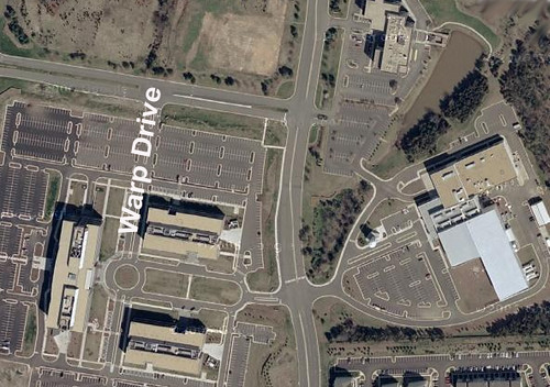
We blogged about getting a space job before, but now it looks like a few hundred can call their new business address "Warp Drive." That’s right: Warp Drive is an "inside" street name on the corporate campus Orbital Sciences, a company that’s about to expand in Northern Virginia, according to the Washington Post:
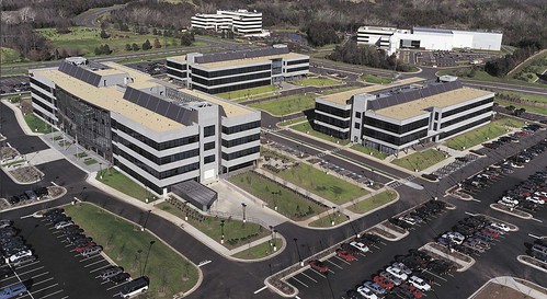
Orbital Sciences, a rocket and space technology manufacturer for the government and military, is embarking on a major expansion of its headquarters in Dulles, adding as many as four buildings and about 600 jobs to its campus.
The company’s 77-acre campus along Route 28 employs 1,500 workers. More than 100 employees work at leased office space a few miles down the road, and Orbital continues to grow. To date, the company said it has $4 billion worth of backlogged contracts.
"Orbital’s business is doing extremely well and growing quite rapidly," said Barron Beneski, a company spokesman.
The buildings — totaling 140,000 square feet — will house office, engineering and manufacturing space on an undeveloped tract of land adjacent to the campus. Construction on the first building has been approved by Loudoun County and is scheduled to begin in early 2008. The first new employees could occupy the space in 2009.
"The next several years we will build buildings as the need arises," Beneski said.
The federal government is Orbital Sciences’ biggest customer. The satellite company has contracts with the Defense Department and military intelligence agencies.
Space flight, in particular, is fueling much of Orbital Sciences’ growth, Beneski said. In 2010 NASA plans to retire the Space Shuttle. The company is part of a team led by Lockheed Martin that is producing the next generation of manned spacecraft to launch astronauts to the moon and beyond. The company stands to make $450 million to $500 million over the next 12 years from its role in the program.
Orbital also manufactures commercial communication satellites for companies such as Intelsat and SES Global. "In the Washington area, there’s not a whole lot of manufacturing going on," Beneski said. "Consultants and IT people produce a lot of paper and gigabytes. We actually produce real stuff."
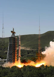
CBERS-2B é lançado com sucesso da base chinesa de Taiyuan
Exatamente às 00h26min desta quarta-feira (19) foi lançado com sucesso o CBERS-2B, terceiro satélite da parceria entre Brasil e China. O evento foi comemorado tanto no Centro de Controle de Satélites do INPE, em São José dos Campos (SP), como no Centro de Lançamento de Satélites de Taiyuan. O diretor do INPE, Gilberto Câmara, assistiu ao lançamento na base chinesa e, junto com os engenheiros Ricardo Cartaxo e Jânio Kono, respectivamente coordenador geral e coordenador do Segmento Espacial do Programa CBERS, transmitiu todas as informações aos técnicos e convidados que acompanharam da sede do Instituto.
“É uma emoção muito grande. É o resultado de um grande trabalho feito por brasileiros e chineses. Estamos todos muito orgulhosos”, disse o diretor Gilberto Câmara.
Chefe do Centro de Controle de Satélites do INPE, Pawel Rosenfeld manteve contato constante com Jânio Kono, coordenador do Segmento Espacial do Programa CBERS, que da base comandou as operações junto com os técnicos chineses.
O foguete Longa Marcha 4B cumpriu perfeitamente todas as etapas previstas para colocação do satélite em órbita. O tempo total de vôo até a injeção do CBERS em órbita foi de 12,5 minutos. O CBERS-2B é lançado com seus transmissores ligados permitindo assim que a estação de rastreio de Nanning, na China, mantenha contato com o satélite desde antes de sua separação do último estágio do veículo lançador, até aproximadamente um minuto e meio após a abertura dos painéis solares, que aconteceu cerca de 14 minutos após o lançamento.
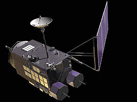
The spacecraft is capable of producing images such as this beauty of Manaus:
A joint mission developed by China and Brazil was shot into an orbit circling Earth’s poles to snap detailed images of the globe during an early Wednesday launch from China’s northeastern space base.
A Long March 4B rocket launched with the international satellite at 0326 GMT Wednesday (11:26 p.m. EDT Tuesday) from the Taiyuan space center in China’s Shanxi province, according to the state-run Xinhua news agency.
The booster’s three liquid-fueled stages accurately deposited the third China-Brazil Earth Resources Satellite into a Sun-synchronous orbit about 12 minutes after liftoff.
CBERS 2B was left in a nearly circular orbit with an average altitude of approximately 462 miles, Xinhua reported. The Long March 4B was shooting for an orbital inclination of 98.5 degrees.
Wednesday’s launch marked the 60th consecutive success for China’s Long March rocket fleet. It was also the 8th space launch for China so far this year.
CBERS 2B will spend the next few weeks undergoing systems tests and preparations for an operational mission expected to last at least two years.
The 3,200-pound satellite was ordered by Chinese and Brazilian officials in 2004 to bridge the gap between older spacecraft and next-generation satellites, which should begin launching in 2009.
The craft’s predecessors, CBERS 1 and CBERS 2, were launched by Chinese rockets in 1999 and 2003, respectively. Both outlived their baselined two-year missions, according to Brazil’s National Institute for Space Research, a co-sponsor of the program.
The China Academy of Space Technology was in charge of the Chinese contribution to the mission, Xinhua reported.
CBERS 2B carries three primary imaging cameras to take a wide range of pictures of locations scattered throughout the world.
A low-resolution camera with a 60-degree field of view will specialize in capturing images of large swaths of the planet. Another camera will be capable of taking pictures with a resolution of about 65 feet.
Unlike its forerunners, CBERS 2B includes a high-resolution black-and-white camera able to produce images showing objects as small as 2.5 meters, or about eight feet. CBERS 1 and CBERS 2 each carried an infrared scanning instrument instead.
Scientists expect to use data from the project in environmental monitoring, crop planning and managing water resources. Images can also be used to identify types of vegetation and in soil surveys. Pictures could also end up in geography textbooks, according to Brazilian space officials.
Images from the new high-resolution camera will also be useful in urban planning and military intelligence applications for China and Brazil.
China has a 70 percent stake in the 19-year-old program, while Brazil controls about 30 percent of the project. Users in both nations have access to the satellite imagery.
Pictures from the spacecraft have been distributed online since 2004, and more than 15,000 users have downloaded about 320,000 images since the Internet campaign began, according to Brazilian officials.
Two more satellites with four cameras each will be launched in 2009 and 2011. The program extension was approved in 2002, and China and Brazil will equally split responsibility for the new project.
Here’s a video about the Brazilian Space Agency:
And here’s a little Brazilian space center tribute video set to Brazilian metal (mind the volume):
We’ve written before about the growing market for maritime satcom for large ships. Now, SES NEW SKIES is teaming up with SeaMobile’s Maritime Telecommunications Network (MTN) product group for extensive field tests of new miniaturized VSAT antennas, which will enable an array of satellite-based communications services for small vessels:
SeaMobile and SES NEW SKIES will test two new 60cm VSAT antennas, that set new standards with respect to size and weight of VSAT installations: the heavy-duty “Ruggidized” for fishing, work boats and oceangoing support vessels, and the lighter “Sure Lock”, which at less than 90lbs addresses more specifically the sailing, yachting and power boat markets. Both antennas use iDirect Spread Spectrum technology, allowing for small-sized, lightweight antennas which are effectively shielded against adjacent satellite interference. SES NEW SKIES is providing Ku-band capacity for the Spread Spectrum Technology demonstrations on its NSS-7 satellite at the orbital location of 338° East….
States Scott Sprague, Senior Vice President Global Sales of SES NEW SKIES: “Small-sized and light-weight VSAT antennas open up completely new markets for small vessel broadband connectivity, be it for professional use, navigation support, safety services or pure leisure/entertainment. The SES NEW SKIES global satellite fleet is particularly well positioned to support communications on the move, be it maritime, land- or air-based.”
SeaMobile Enterprises, a provider of at-sea communications and connectivity, announced Tuesday that it has reached a service agreement with Global Marine Systems, an independent, undersea cable installation and maintenance company. Terms of the three-year contract were not disclosed. SeaMobile said it will provide its Maritime Telecommunications Network satellite services aboard three Global Marine vessels. SeaMobile said it has already installed its MTN VSAT satellite services on two of the ships and expects to address the third later this month. Global Marine Systems is based in Chelmsford, England. SeaMobile is headquartered in Seattle and provides broadband and satellite services for more than 300 maritime vessels.
Stratos has also recently entered the maritime satcom marketplace, while Schlumberger is working to build a model that integrates land and sea.
The WorldView 1 satellite, built for DigitalGlobe, which supplies much of Google Earth’s imagery, was lofted into space aboard a Delta 2 rocket [from Vandenberg Air Force Base]. The satellite separated from the rocket about an hour after liftoff and was circling 300 miles (480 kilometers) above Earth.
WorldView 1 was designed to collect up to 290,000 square miles’ (750,000 square kilometers’) worth of imagery a day — an area about the size of Texas. Information gathered by the 5,000-pound (2,270-kilogram) probe can be used by governments and companies to assess damage after a natural disaster or plan escape routes before a catastrophe, the company said.
Images and details about the bird can be found on the DigitalGlobe website. Features include an "ultra-stable platform, high-precision attitude sensors and GPS" that "allows the creation of accurate maps in remote areas, maximizing the utility of whatever resources are available," as well as the "highest commercially available" resolution, with direct downlink of those images available to customer sites using a high-speed 800 Mbps X-band downlink.
In June, we discussed the naming of Japan’s new lunar study — what many consider the most sophisticated lunar exploration mission in the post-Apollo Era. It is also Japan’s first major lunar mission. Last Friday morning, the spacecraft launched from Tanegashima island, 600 miles south-west of Tokyo, aboard an H-2A solid-fuel rocket:
The mission of the SELenological and ENgineering Explorer “KAGUYA” (SELENE), Japan’s first large lunar explorer, is being keenly anticipated by many countries.
The major objectives of the mission are to understand the Moon’s origin and evolution, and to observe the moon in various ways in order to utilize it in the future. The lunar missions that have been conducted so far have gathered a large amount of information on the Moon, but the mysteries of its origin and evolution have been left unsolved.
KAGUYA will investigate the entire moon in order to obtain information on its elemental and mineralogical composition, its geography, its surface and sub-surface structure, the remnant of its magnetic field, and its gravity field. The results are expected to lead to a better overall understanding of the Moon’s evolution.
At the same time, the observation equipment installed on the orbiting satellite will observe plasma, the electromagnetic field and high-energy particles. The data obtained in this way will be of great scientific importance for exploring the possibility of using the moon for human endeavors.
KAGUYA consists of the Main Orbiter and two small satellites (Relay Satellite and VRAD Satellite). The Main Orbiter will reach the vicinity of the Moon. Once it has reached the Moon, it will be placed into a peripolar orbit at an altitude of 100 km. The Relay Satellite will be placed in an elliptic orbit at an apogee of 2400 km, and will relay communications between the Main Orbiter and the ground station. The VRAD Satellite will play a significant role in measuring the gravitational field around the Moon. The Main Orbiter will be employed for about one year and will observe the entire Moon.
Is this the start of an Asian Space Race? The Guardian sees some evidence:
While Jaxa officials play down talk of a space race with China, the mission is a major step towards the goal of building a manned station on the moon by 2025, and a sign of renewed regional interest in lunar exploration. China is to send its Chang’e-1 probe to the moon this year to construct 3-D images of the moon’s surface and analyse its dust. India is expected to launch an unmanned lunar orbiter next year.
My senior year of High School I read the newly released book Longitude, which detailed the scientific quest for an accurate and durable method for determining longitude at sea. The prize: the equivalent of 12 million in today’s currency. I couldn’t help wonder why our scientific innovation wasn’t promoted in the same way. Sure, government and university grants are great for scientific progress but so is a little healthy competition and the prospect of massive wealth.
Imagine my excitment when I read about the X-Prize, announced at about the same time as the publication of Longitude. In 2004, the X Prize awarded its first prize of $10 million to Burt Rutan and Paul Allen for developing the first non-government, reusable manned spacecraft that was launced into space twice within two weeks.
The X-Prize Foundation lives, offering prizes for a number of contests from genome sequencing technology to building a 100-mpg vehicle.
Now, Google is getting into the game. The Google Lunar X-Prize will offer $20 million to the first team that constructs autonomous rovers that can land on the moon, travel at least three-tenths of a mile, and send video, images and data back to Earth. Google is running the project in conjunction with the X-Prize foundation. MSNBC has the details:
The first team to succeed would win $20 million – that is, if the job is done by 2012. After that, the prize drops to $15 million, and if no one is successful by the end of 2014, the money could be withdrawn. If a second team succeeds before the deadline, $5 million would be given as a runner-up prize. Another $5 million would be reserved for bonus tasks – for example, roving for longer distances, taking pictures of old lunar spacecraft, finding water ice or surviving the long lunar night.
The imagery and other data beamed back from the moon would be shared with the world via the Google Lunar X Prize’s Web site.
“By working with the Google team, we look forward to bringing this historic private space race into every home and classroom,” Peter Diamandis, chairman and chief executive officer of the California-based X Prize Foundation, said in a prepared statement. “We hope to ignite the imagination of children around the world.”
Watch the promotional video, find an extremely wealthy sponsor and some rocket scientists, then get to work, folks.
Nothing like reverting to early 18th Century contests to solve the technological challenges of the 21st Century and beyond.
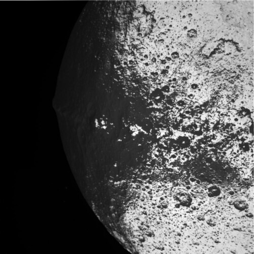
After "a solid state power switch that was tripped due to a galactic cosmic ray hit", the Cassini-Huygens spacecraft went into safe mode earlier this week. It’s recovered since and the fly-by was very cool:
Mission controllers have since sent commands for Cassini to resume normal transmission, and scientists recovered all the data from the moon flyby despite a nearly 12-hour delay. The spacecraft was expected to be fully functional by week’s end.
Iapetus, the third-largest Saturnian moon, gained science fiction fame in Clarke’s mind-bending novel "2001: A Space Odyssey," that was developed in concert with Stanley Kubrick’s 1968 movie by the same name.
Clarke, who lives in Sri Lanka, surprised the Cassini team with a five-minute video played Tuesday during an internal meeting at NASA’s Jet Propulsion Laboratory. In it, Clarke told scientists he looked forward to viewing photos from the flyby.
Even before Clarke’s taped greeting, scientists waxed poetic about Cassini’s encounter with Iapetus and the fictional Discovery spaceship’s rendezvous with Japetus, as the Saturn moon is known in Clarke’s book.
Video greeting to NASA JPL to mark the Iapetus flyby of Cassini spacecraft: 10 September 2007
by Arthur C. Clarke
Hello! This is Arthur Clarke, joining you from my home in Colombo, Sri Lanka.
I’m delighted to be part of this event to mark Cassini’s flyby of Iapetus.
I send my greetings to all my friends – known and unknown – who are gathered for this important occasion.
I only wish I could be with you in person, but I’m now completely wheelchaired by Polio and have no plans to leave Sri Lanka again.
Thanks to the World Wide Web, I have been following the progress of Cassini-Huygens mission from the time it was launched several years ago. As you know, I have more than a passing interest in Saturn…
And I was really spooked in early 2005, when the Huygens probe returned sound recordings from the surface of Titan. This is exactly what I had described in my 1975 novel Imperial Earth, where my character is listening to the winds blowing over the desert plains overhead.
That was perhaps just a foretaste of things to come! On September 10, if everything goes according to plan, Cassini would give us our closest look at Iapetus – one of Saturn’s most interesting moons.
Half of Iapetus appears as dark as asphalt, and the other half is as bright as snow. When Giovanni Cassini discovered Iapetus in 1671, he could only see its bright side. We had a better glimpse when Voyager 2 flew past in August 1981 – but that was from almost a million kilometres away.
In contrast, Cassini is going to come within a little over one thousand kilometres of Iapetus.
This is a particularly exciting moment for fans of 2001: A Space Odyssey – because that’s where the lone astronaut Dave Bowman discovers the Saturn monolith, which turns out to be a gateway to the stars. Chapter 35 in the novel is titled ‘The Eye of Iapetus’, and it contains this passage: "Iapetus was approaching so slowly that it scarcely seemed to move, and it was impossible to tell the exact moment when it made the subtle change from an astronomical body to a landscape, only fifty miles below. The faithful verniers gave their last spurts of thrust, then closed down forever. The ship was in its final orbit, completing a revolution every three hours at a mere eight hundred miles an hour – all the speed that was required in this feeble gravitation field."
After more than 40 years, I cannot remember why I placed the Saturn monolith on Iapetus. At that time, in the early days of the Space Age, earth-based telescopes couldn’t show much details of this celestial body. But I have always had a strange fascination for Saturn and its family of Moons. By the way, that ‘family’ has been growing at a very impressive rate. When Cassini was launched, we knew of 18 moons. I understand it is now 60 – and counting…I just can’t resist the temptation to say:
My God, it’s full of moons!
But in the movie, Stanley Kubrick decided to place all the actions at Jupiter, not Saturn. Why this change? Well, for one thing it made a more straightforward storyline. And more importantly, the special effects department couldn’t produce a Saturn that Stanley found convincing.
That was just as well…because if they had done so, the movie would have been badly dated by the Voyager missions, which showed Saturn’s rings to be far more implausible than anyone had ever imagined.
I have seen enough instances where Nature imitates art, so I’m going to keep my fingers crossed on what Cassini discovers at Iapetus.
I want to thank everyone associated with this mission and the overall Cassini-Huygens project. It may lack the glamour of manned spaceflight, but science projects are tremendously important for our understanding of the Solar System. And who knows, one day our survival on Earth might depend on what we discover out there…
This is Arthur Clarke, wishing you a successful flyby.
African development continues to be a hot topic in the world of sat- and tele-com, with a debate currently taking place about Telkom’s SAT-3 undersea cable and the countries it does (and doesn’t) serve:
The biggest problem with Telkom’s SAT-3 undersea cable is that it never went bankrupt, said Johan Meyer, Telkom’s group executive for global capacity service.
Meyer, who has been intimately involved in the SAT-3 West Coast cable, which is SA’s primary undersea link for telecommunications and Internet connectivity with the rest of the world, said: “If SAT-3 had gone bankrupt, then we would have had a very different scenario to what we have today, and may even have found ourselves in a similar position to the North Atlantic cables.”
He was responding yesterday to comments made during a debate on pan-African connectivity at the Capacity Africa 2007 Conference, in Cape Town.
Wessel van der Vyver, GM of international business for Telecom Namibia, opened the discussion by saying that Telkom was one of the key impediments to his company lowering its own broadband and interconnectivity costs.
“Essentially, Nambia is a landlocked country in terms of undersea cable because SAT-3 lands in Angola and in SA. We were hoping to get a landing in Namibia, but this hasn’t happened.”
Later, Van der Vyver said Telecom Namibia was also “disappointed” that the proposed undersea cables being planned by the South African government’s new broadband infrastructure supplier, Infraco, was also ignoring his country.
“It would be a pity if another cable is built and it leaves us in the same situation.”
During the discussion, the lack of satellite capacity came under the spotlight.
Pedro Camacho, CEO and owner of Blue Sky Satellite Communications, said satellite capacity was at a premium, with a long waiting list.
Need some background on the SAT-3 cable? Look here:
SAT3/WASC/SAFE is a historic Achievement made possible by the participation of 36 nations, the majority of the landings are in African states. Together they have fully funded the undersea cable system costing more than US$600 million and will own and operate it for the next 25 years. This results in much of the revenue it generates being ploughed back into the continent. This is a major departure from the current scenario, where many African countries rely on foreign operators to route their international traffic which results in revenue generated in Africa, leaving Africa.
South Africa’s communications authority granted fixed-line operator Telkom’s media unit, Telkom Media, and leisure and media group Hosken Consolidated Investments licences along with two smaller operators — On Digital Media and Walking on Water.
Entry of new operators is expected to stimulate the market, with more money being pushed to marketing pay-TV services, portfolio manager Khulekani Dlamini at Renaissance Specialist Fund Managers said.
Chief Executive Officer Nolo Letele of Naspers’ local pay-TV operation MultiChoice SA said the unit had been gearing up for competition.
"We will have to fight that much harder for the disposable rand in people’s pockets," Letele said after the announcement of the winning bidders.
With increasing demand continent-wide for better broadband, television, and voice connections, the communications landscape in Africa is sure to remain fluid for many years. We’ll keep you updated on the latest developments.
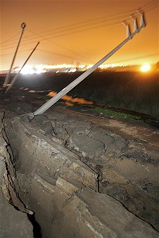
Last month’s devastating magnitude-8 earthquake in Peru killed more than 500 people and knocked down or damaged thousands of buildings in Peru’s southern desert cities of Ica and Pisco.
In the midst of such devastation, conditions are exacerbated by lack of communications with the outside world, as landlines are inevitably severed by falling debris.
That’s why satcom plays such a critical role in disaster recovery. In the days following the earthquake in Peru, engineers from Télécoms Sans Frontières leaped into action. The BBC reported on August 17th:
The five-strong team will deploy satellite telephone and internet access in three centres – at Pisco, where the quake hit hardest, Ica and Chincha.
Julie Cazenave, who is leading the team, said: "There is a lot of confusion right now because there is little information from the areas hit."
The priority will be to establish telecoms at the airport in Pisco.
Telecoms Sans Frontieres (TSF) is charity that works with the United Nations and the European Commission’s Humanitarian Aid Office (ECHO) to restore communications in disaster-hit areas and the developing world.
"There are no power lines to charge phones. In the affected areas there are no landlines, no internet," said Ms Cazenave.
TSF was critical in reconnecting families that had lost track of each other following the quake:
The relief team from TSF’s Americas base, composed of 5 specialist in emergency communications transports satellite communication equipment (Inmarsat BGan terminals, RBGan, GAN M4 and Mini M) as well as computer equipment to provide internet connections, telephone lines and fax….
During a calling operation on Tuesday, Carmen Hernandez called her son who lives in Spain and testified on the violence of the quake:
"- Mom, where are you calling from? Your voice is trembling, are you sure everything is alright?
"Don’t worry, please keep talking, it’s so good to hear your voice. We’re lacking everything here but we’re alive. When you come back, you won’t recognize Pisco. I’m calling from a satellite phone, a free called offered by an international NGO. Don’t worry son, stay where you are."
The Peruvian earthquake isn’t the only recent natural disaster where TSF has lent a hand:
Still in operation in Pisco following the earthquake which stroke Peru, Télécoms Sans Frontières intervenes in the area of the RAAN (North Atlantic Autonomous Region) from its Latin America base taking care of the victims of the Felix Hurricane.
Tuesday, the Felix cyclone (category 5) devastated Northern Nicaragua, involving the increase of human losses and the number of disaster victims which could exceed 500 000 people. Facing this disaster, the President of Nicaragua invited the international community to provide a humanitarian aid for the victims.
From their base in Managua, 5 logisticians of Telecoms Sans Frontieres arrived on the ground by helicopter, providing assistance to the relief organizations and United Nations agencies by deploying communication centers in Puerto Cabezas. These installations include Inmarsat terminals, BGan, Gan M4, Minis M and laptops. Efficient telecommunications infrastructure plays a crucial role ensuring the success of emergency coordination. Additional TSF centers will be installed in Sandy Bay and Waspan from today.
At the same time, the TSF teams will offer to each disaster affected family a free call to a relative, which could provide them psychological assistance as well as immediate response to their needs.
ITU has also played a critical role in restoring vital communications to Peru, deploying 50 satellite terminals in remote and underserved areas.
For more information on Télécoms Sans Frontières, click here.
The Phoenix Mars Lander has passed its first in-flight check. The collaborative project, part of NASA’s Mars Scout class, is headed by the Universtiy of Arizona but includes efforts by Lockheed-Martin and The Max Planck Institute. The mars lander, slated to explore the arctic region of mars, analyzing samples of soil and ice, launched on August 4th and is expected to land on May 25, 2008. Last week, it received its first in-flight report, including a photo taken from its robotic arm camera:
The Robotic Arm Camera took an image of the Robotic Arm scoop using its red LED (Light-Emitting Diode) lamp. Human eyes see this image only in shades of gray, so the picture has been enhanced in false color to better represent what the camera sees.
Images from the Robotic Arm Camera, one of five imaging instruments on the lander, will be the only pictures taken and returned to Earth until Phoenix approaches and lands on Mars on May 25, 2008. Additional images will be taken by the Robotic Arm Camera later in the cruise stage.
The Robotic Arm Camera check was one of a series of instrument tests being completed as Phoenix cruises toward the red planet. Phoenix was about 57 million miles from Earth when the image was sent back. It is traveling at 76,000 miles per hour in relation to the sun.
On Mars, the Robotic Arm will dig trenches, scoop up soil and water-ice samples and deliver them to several instruments on the lander’s deck for chemical and geological analysis.
The Robotic Arm Camera, built by the UA and Max Planck Institute, is attached to the Robotic Arm just above the scoop and will provide close-up, full-color images of the Martian surface, prospective soil and water-ice samples, samples collected in the scoop before delivery to the lander’s science deck, and of the floor and side walls of the trenches.
While the photo doesn’t look like much, it provides welcome relief to the project team. From the project’s excellent blog:
At the moment all we have to look at is the scoop on RA that we’ll use to dig into the surface of Mars. Although we see numbers flow back during these health checks, a picture is something very tangible. It tells us in an image what it takes pages of numbers to understand. We see a sharp focus, the lights are on, the multitude of commands executed properly, the data pipe that the images stream down all work, After all RAC is a camera, all the work is to have an instrument that takes images and the result is we get a picture here on Earth from tens of millions of miles from home. Makes me confident we’ll get back pictures after we land on Mars.
I find this very comforting. Not only have we endured launch, deep cold of space, but we also survived the Van Allen Radiation Belts that surrounds the Earth (some 1500 rems / year compared to 0.04 here on earth). We’ve prepared for this and we’d prepared well. It certainly is exciting to see our hearty little friend is healthy so far from Earth on her extraterrestrial journey to her new home on Mars.
The same in-flight check returned the lander’s cruising temperature (a touch colder than a Wisconsin winter):
So far all looks well on the spacecraft and the instruments are at a balmy -30° C with some places near 0°C. The RAC at a comfortable -15°C!So much for the interplanetary weather report.
Meanwhile, the weather on Mars isn’t much better. Earlier this summer, a global dust storm swept the red planet creating a sky-darkening dust clout, nearly killing NASA’s solar-dependent exploration rovers. The rovers, Spirit and Opportunity, have worked 40 months more than their original 3-month goal. Along the way, they’ve survived a lot:
"These rovers are tough. They faced dusty winds, power starvation and other challenges — and survived. Now they are back to doing groundbreaking field work on Mars. These spacecraft are amazing," said Alan Stern, associate administrator of NASA’s Science Mission Directorate, Washington.
Let’s hope the Phoenix has similar longevity. So far, so good.


 Last month’s