Archive for the ‘Satellites’ Category

Even More Shuttle Video

Tuesday, July 11th, 2006

Just in case you didn’t get enough video in yesterdays post, Phil over at Bad Astronomy points to even more NASA video of the July 4th space shuttle launch, with camera angles from on top and right aft of the starboard solid rocket booster.

The NASA videos area without audio, but here’s a YouTube video of the launch with a play-by-play of the launch.

Monday Morning Videos

Monday, July 10th, 2006

Here’s a couple of videos to get your Monday started with a bang. Via Mars Blog, here’s a NASA video of the STS-121 solid rocket booster separating from the space shuttle. (Can’t view the video? Check out the Flickr photoset of the view from earth.)

Also, a little late for the 4th of July but fun to watch nonetheless, here’s a YouTube video of 30,000 bottle rockets launched in 2 minutes.

How to Deliver Goods to the International Space Station

Friday, July 7th, 2006

After performing a backflip to allow crewmembers of the International Space Station to inspect its belly (and to provide cool images for space fans everywhere), Discovery docked with the ISS yesterday.

The big item on the mission agenda today? Moving supplies

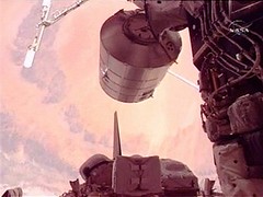
The astronauts moved a huge cargo container, nicknamed Leonardo, onto the space station by robotic arm. Among the goodies awaiting the space station crew were a new stationary bicycle for exercise, an oxygen generator that will eventually allow the space station to support six inhabitants, a machine that cools the station’s cabin air and a lab freezer for scientific samples…

For the first time in three years, the international space station had three crew members. European Space Agency astronaut Thomas Reiter joined Pavel Vingogradov and Jeff Williams, who marked their 100th day at the space station Friday.

The shuttle isn’t the only means of delivering supplies to the ISS, of course. Earlier this week, the European Space Agency announced the successful completion of acoustic testing on "Jules Verne," the first Automated Transfer Vehicle: 

The ATV, an unmanned vehicle that will deliver supplies to the International Space Station (ISS), will be put into orbit by the European Ariane-5 launcher. Acoustic testing is vital to ensure the ATV can withstand the vibrations caused by the extreme noise levels generated during launch.


Satellites Aid Voluntary High-Seas Trawling Ban

Thursday, July 6th, 2006

Here’s an interesting story out of the Indian Ocean:

In a global first, four major fishing companies announced today a voluntary halt on trawling in eleven benthic-protected areas in the southern Indian Ocean. This will protect and conserve the benthic and associated fish fauna and related biodiversity in one of the largest marine protected area enclosures ever.

By setting aside an area almost equal to Australia’s Great Barrier Reef National Park, these businesses are sending a clear signal that they want to keep fish on people’s plates for generations to come…

Using the scientific knowledge gathered over a decade of activity in the Indian Ocean and in consultation with staff of the Fisheries Department of the United Nations Food and Agriculture Organization (FAO), SIODFA have delimited 309 000 km2 of ocean floor in eleven separate benthic protected areas — a total zone with an area approximately the size of Norway — where their vessels will no longer fish. To verify compliance with these self-imposed restrictions, the companies will track their vessels’ locations and activities via a special satellite monitoring system.

We’ve written before about how scientists are using satellites to study ecosystems, land and water usage and climate change– but to the best of our knowledge, this is the first time we’ve heard of satellites being used for enforcement of voluntary conservation measures.

 
Do you know of any other examples? If so, please post them in the comment threads and we’ll highlight them here.

UFO Threatens Space Station

Tuesday, June 27th, 2006

How’s that for a hyperbolic headline? It’s rooted in fact:

MOSCOW – An unknown floating object close to the International Space Station ISS has concerned ground control, according to reports from the US Space Agency NASA on Tuesday.

The object is approximately 2.8 kilometres away from the International Space Station, said the Russian flight control centre in Moscow, citing a NASA source.

The situation… does not yet require a dodge manoeuvre…..

“The object has no number in the list of space debris,” Kireyev said, according to reports from the Russian Itar-Tass agency.

“It is however probably an old piece of space exploration equipment.”

If the object gets any closer to the ISS, astronauts Jeff Williams and Pavel Vinogradov would have to take the precaution of moving to the rescue space shuttle Soyuz TM.

A dodge manoeuvre could cause difficulties for the docking of the US space ship “Discovery”, due to be launched on July 1.

Perhaps the astronauts should practice on this game.

New Satellite Service By 2012?

Monday, June 26th, 2006

The FCC has proposed allowing new satellite service in the 17 and 24 gigahertz band spectrum — a proposal which, if passed, could add new competition to satellite radio and other emerging broadcast industries, Billboard Radio Monitor reports:

 In an email exchange with Billboard Radio Monitor, one high-level engineering source wrote that “the ‘Ka-Band’ frequencies (18 GHZ to 40 GHZ) usually suffer from extreme susceptibility to rain-out and fog failure conditions. On the plus side, the satellite antennas (up in orbit) can send more spot-area signals to different parts of the [continental U.S.], potentially creating individual market coverage signals, which can’t effectively be done at 2.3 GHZ.”

Radio Monitor sources and industry observers estimate that the shortest possible timetable for a new satellite service to make its way through the FCC, onto the launch pad and into space would be five or six years.

The FCC’s Notice of Proposed Rule Making (NPRM) for establishing a new satellite service was originally going to be part of the commission’s Open Meeting agenda but it was deleted at the last minute. Instead, the FCC’s commissioners handled the vote later in the day, with all five commissioners approving the NPRM.

An FCC press release about the Notice says the service “holds the potential of bringing a new generation of innovative satellite services to American consumers—providing a mix of video, audio, data and multimedia services to residential and business subscribers.”


Nix and Hyrda

Monday, June 26th, 2006

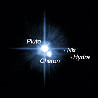
In other Hubble news (see the post below), a pair of small moons orbiting Pluto, first photgraphed by the Hubble Telescope in 2005, now have official names: Nix and Hyrdra.

"Nix and Hydra are roughly 5,000 times fainter than Pluto and are about two to three times farther from Pluto than its large moon, Charon, which was discovered in 1978," according to the official Hubble website.

Hubble’s ACS Camera Offline

Monday, June 26th, 2006

The Hubble Space Telescope’s Advanced Camera for Surveys (ACS) has been offline since June 19, Space.com reports:

ngineers have yet to figure out what caused the Advanced Camera for Surveys (ACS) to go into "safe mode," essentially a sleep state that prevents normal operations. But the outlook is bright.

"We’re very optimistic" that the camera will be fixed, said Ed Ruitberg, associate program manager for Hubble at NASA’s Goddard Space Flight Center.

Ruitberg told SPACE.com that some potential causes have been ruled out and that the problem is likely with a low-voltage power supply interface, something between the batteries and a camera component. If that’s the case, then redundant electronics can be relied on to bypass the problem area.

"We’re still investigating the problem and working on all sorts of contingencies," said Max Mutchler at the Space Telescope Science Institute (STScI) in Baltimore, where Hubble’s science operations are run. "We’re hoping for the best but preparing for other contingencies."

Space Daily also reports on Hubble’s troubles. 

We’ll keep you updated on the efforts to "wake up" the camera….

Mitex Launches Successfully

Friday, June 23rd, 2006

UPI files the report:

The Delta II rocket launched Wednesday at Cape Canaveral carried a pair of small satellites for the U.S. Defense Advanced Research Projects Agency (DARPA) Micro-Satellite Technology Experiment. The program looks into new spacecraft technologies that could be applied to future military space projects.

Boeing and its crew of subcontractors reported Thursday that the Delta II in its 7925-9.5 configuration performed flawlessly with the payload deploying some 30 minutes after launch in geostationary orbit more than 22,000 miles above the equator….

The rocket was equipped with nine GEM-40 solid-fuel booster rockets that augmented liftoff thrust to 850,000 pounds to which another 450,000 pounds was added three minutes downrange.


GeoEye Awarded Airport Mapping Project

Thursday, June 22nd, 2006

There’s little doubt that satellite technology has transformed aviation. From the widespread use of GPS technology to the in-flight weather updates provided to pilots through services like XM Satellite Weather, satellite-delivered content and information has greatly increased the situational awareness of pilots and, in turn, made aviation safer.

Yet any gadget is only as useful as the underlying information, which is why the National Geospatial-Intelligence Agency (NGA) Stereo Airfield Collection program has awarded Dulles-based GeoEye a $3.7 million contract to image 365 airfields and produce Airport Mapping Databases (AMDB) over a 12-month period:

GeoEye is now the world’s largest developer of airport geospatial information support, terrain and obstacle databases with several hundred airfields mapped to date. Matt O’Connell, GeoEye’s president and chief executive officer said, "We are a leader in providing airport geospatial solutions to key customers like the NGA and the USAF at the best price and with the best performance in the industry."

An Airport Mapping Database is a geospatial database that contains significant features of an airport such as runways, taxiways, buildings, obstacles and terrain surrounding an airfield. This information supports the safe movement of aircraft and helicopters on runways and taxiways. These products can also be used to support training, mission or contingency planning and visual simulations for ordinary operations or crisis situations. GeoEye is uniquely positioned to fulfill this contract for North American and international airfields by virtue of its IKONOS satellite’s ability to generate a three-dimensional image from stereo data collected during a single orbital pass. The result is a three-dimensional map-accurate image of an airport that can be quickly and cost effectively acquired.