Archive for the ‘Space Business’ Category

Satellites Aid Voluntary High-Seas Trawling Ban

Thursday, July 6th, 2006

Here’s an interesting story out of the Indian Ocean:

In a global first, four major fishing companies announced today a voluntary halt on trawling in eleven benthic-protected areas in the southern Indian Ocean. This will protect and conserve the benthic and associated fish fauna and related biodiversity in one of the largest marine protected area enclosures ever.

By setting aside an area almost equal to Australia’s Great Barrier Reef National Park, these businesses are sending a clear signal that they want to keep fish on people’s plates for generations to come…

Using the scientific knowledge gathered over a decade of activity in the Indian Ocean and in consultation with staff of the Fisheries Department of the United Nations Food and Agriculture Organization (FAO), SIODFA have delimited 309 000 km2 of ocean floor in eleven separate benthic protected areas — a total zone with an area approximately the size of Norway — where their vessels will no longer fish. To verify compliance with these self-imposed restrictions, the companies will track their vessels’ locations and activities via a special satellite monitoring system.

We’ve written before about how scientists are using satellites to study ecosystems, land and water usage and climate change– but to the best of our knowledge, this is the first time we’ve heard of satellites being used for enforcement of voluntary conservation measures.

 
Do you know of any other examples? If so, please post them in the comment threads and we’ll highlight them here.

Chaperone via Cellphone

Thursday, June 15th, 2006

Back in April, I blogged about Sprint’s GPS tracking package aimed at parents who want to keep better track of the cellphone-totting kids. Well, it’s a trend that seems to be catching on. Verizon just rolled out its own “chaperone” service.

Verizon on Monday introduced a new service aimed at parents who wish to keep track of where their children are through their cell phones. Additionally, the service will give children a way to easily contact their parents.

The “Chaperone” service would be provided in conjunction with the kid-friendly LG Migo, a cell phone designed for easy operation by even the youngest users. The system uses GPS capabilities built into the phone in order to track a child’s position.

The parent would be able to see where the phone is located from a map on the Verizon Web site. Additionally, parents can download a cell phone-based application that would perform similar functions, Verizon said.

… Another feature, called Child Zone, provides a service for parents where they would be alerted when the Migo phone leaves a predetermined area. The service would send a text message to the parent’s Verizon phone.

Linux News has screenshots of the locator screen for the Sprint plan, which give some idea of what parents on Verizon’s plan might see when logging on to make sure little Johnny or Susie comes straight home from soccer practice. It also quotes an industry analyst as suggesting that companies offer such services will need to set “realistic expectations for their customers.

LG Migo Phone

I still find myself wondering what other uses folks might find for this technology, like keeping tabs on straying spouses, etc. That the service requires use of Verizon’s LG Migo phone, which adults are unlikely to use, might reduce that threat. Of course, it would be easy enough to slip the phone into the purse, briefcase, car, etc., of the suspected spouse (or anyone else, for that matter) and keep track of their comings and goings while undetected. But, then again, there are already services that track anyone who has a cellphone, so perhaps that segment of the GPS market is already being served.

Flying Robots to Patrol Europe?

Monday, June 5th, 2006

Remember those flying robots we told you about earlier, and how Europe has some of their own. Well, now EU plans on putting those airborne bots to work

uav

Fleets of unmanned "drone" aircraft fitted with powerful cameras are to be used to patrol Europe’s borders in a dramatic move to combat people-smuggling, illegal immigration and terrorism.

The Independent on Sunday can today reveal that the tiny planes will fly at more than 2,500 feet over the English Channel and Mediterranean beaches as part of a £1bn programme to equip Europe’s police forces, customs officers and border patrols with hi-tech surveillance and anti-terrorism equipment.

The aircraft, called unmanned aerial vehicles (UAVs), are already being used by the Belgian government to catch tankers illegally dumping oil in the North Sea. Several ships’ captains have already been prosecuted.

The European Commission now wants to use similar drones, which can have a 6-metre wing-span and weigh as little as 195kg, to patrol the Mediterranean coasts and the Balkans where illegal immigrants try to enter the EU. The Russian government is also close to flying drones over its borders.

Interesting news, but if you ask me they’ll only really be on to something when the put tentacles on those flying robots.

Google Goes Green

Friday, June 2nd, 2006

More interesting uses for Google Maps — the site that brought satellite imagery to your desktop — keep cropping up.

Google Goes GreenGoogle has launched its first mashup–a map-based Web site with information about earth-friendly locations in five of the U.S.’s top travel destinations.

The site, at maps.google.com/green, features information on and video tours of spots in San Francisco, Los Angeles, Las Vegas, New York and Orlando, Fla., as well as tips for "traveling green" during the summer using Google Maps. 

… Listings include the Las Vegas Natural History Museum and the Go Raw Cafe in Las Vegas, the Tree People park and EcoLimo in Los Angeles, the Skyscraper Museum and Central Park in New York, the Forever Florida nature preserve and Horse World Riding Stables in Orlando and, in San Francisco the Red Victorian Bed and Breakfast and the Exploratorium.

But I think my favorite is a non-official mashup called Placeopedia, which matches WikiPedia articles with their locations. You can add a place, or spend click around to various places, which is a great time-waster or way to take a vacation without leaving your desk.

Waiting for the Bus

Friday, May 19th, 2006

Where’s the bus? Satellite technology (combined with your handheld or PDA) may soon provide the answer to that question, at least in Manhattan. NY1 News reports:

A plan using a satellite tracking system for buses is moving forward.

New York City Transit says a pilot program proposed last year could be in place by November.

Technology will allow for website displays with real-time bus locations and arrival times.

Updates would also be available on electronic message boards.

Riders will even be able to access times on your cell phone or blackberry.


And if you had a ringtone to this classic Replacements song — well, then riding the bus would almost be cool.

Theives Track GPS Units

Saturday, May 13th, 2006

Is this a case of "turnabout is fair play" or what? I blogged earlier about some California counties using GPS to track gang members after they’re released from prison. Well, this morning I opened my hometown paper (OK, I "opened" it in my web browser) to learn that in my neck of the woods thieves are tracking GPS units, and have started making off with them instead of expensive car stereos.

More than 50 dashboard-mounted Global Positioning System receivers have been stolen from parked cars in Alexandria and Arlington County since January, and police are urging motorists to hide the units, which range in price from $200 to nearly $3,000.

"It’s basically like leaving $700 in cash on the dashboard and asking someone to take it," said Mary Garrand, crime analyst for the Alexandria Police Department, who has noted about 25 stolen devices this year, mostly from Old Town.

Apparently increased demand for these gadgets among car owners has created increased demand among an unexpected demographic. Of course, if you leave your car unlocked or — as in one case — leave the top down, with your GPS unit attached to the dashboard with a piece of adhesive, you might expect to be relieved of it eventually.

[Detective Damon] Washington, one of several detectives who recently canvassed the hardest-hit areas in Arlington in search of suspects, said it comes down to this: "Don’t leave anything in your car that you’re not willing to lose."

It wasn’t long ago that car stereos started coming with removable faces, to ward off would-be thieves. Most GPS units — the dashboard variety, at least — are removable. So take it with you, or you might not be able to find it later.

If they ever catch the folks who’re heisting these GPS units, once they’re convicted and have served their sentences, I think they should be tracked via GPS upon their release. And nabbed if they come anywhere near a major parking lot. That’d be poetic justice. Dontcha think?

Cellular Love Detector

Tuesday, May 9th, 2006

It’s an idea I’ve had knocking around in my head for a while, or at least since I started writing for this blog. And it may be an idea whose time has come. But given my somewhat limited technological abilities, someone else is gonna have to make it happen.

While pondering the various ways technology might be employed to improve the life of the everyday man or woman on the street, it occurred to me that while exploring the various uses for mobile technologies affairs of the heart were being overlooked. Since scores of people carry mobile phones these days, that allow them to do everything from playing their favorite music via satellite radio to watching their favorite shows, it seems like a no-brainer to use the same technology to track down potential candidates for significant-other status. If I thought of it, surely someone out there with greater technical acumen than me has thought of it and tried to make it a reality. 

Enter the Cellular Love Detector.  It works like this: dial the access number, the number of your latest crush, and talk as you would normally do while the Love Detector does it’s magic and spits out a report. 

Using the Love-Detector Cell Service is as simple as dialing the access number, and your friend’s phone number right after… Once the conversation starts, all you need to do is have a NORMAL conversation. Speak about work, homework, movies or any other thing. …

During the call, our server will monitor the excitement levels and other related parameters your friend is demonstrating, and will calculate the "Love-Level" as detected in the conversation. Once the conversation has ended, the final report will be sent to your cellular phone using SMS or audio message! The final report is not only about the "Love-Level", and includes other parameters, like "Concentration", "Embarrassment" and even "Anticipation".

Sounds like an interesting idea, and one that may be useful to folks who are impaired when it comes to detecting mutual admiration. But I don’t think it goes far enough. 

Look, we already know how easy it is to track someone down using various technologies. We can use GPS to track down lost pets and roving gang members. We can use GPS and cell phones to track down wandering teenagers. And I just read that it’s pretty easy to track anybody who’s carrying a cell phone, whether they make calls or not. 

Most people know that when they make a mobile call—during a 911 emergency, for example—authorities can access phone company technology to pin down their location, sometimes to within a few feet.

A lesser-known fact: Cell phone companies can locate you any time you are in range of a tower and your phone is on. Cell phones are designed to work either with global positioning satellites or through “pings” that allow towers to triangulate and pinpoint signals. Any time your phone “sees” a tower, it pings it.

Here’s a more straightforward explanation

Real-time tracking of cell phones is possible because mobile phones are constantly sending data to cell towers, which allows incoming calls to be routed correctly. The towers record the strength of the signal along with the side of the tower the signal is coming from. This allows the phone’s position to be easily triangulated to within a few hundred yards.

The technology is already within reach of consumers. You can sign up for services like AccuTracking, World Tracker, or ULocate. For that matter you can build your own. So, the genie is out of the bottle and unlikely to go back in. 

Why not put it all together in the service of matchmaking? The Google Earth Blog had the same premonition I did, upon hearing news of at least one dating service letting customers use Google Earth to locate prospective dates.

It can only be a matter of time before other dating services implement a Google Earth interface for showing approximate locations for prospective dates. It would be a smart move in my opinion and not too difficult to implement technically.

Exactly. At least one dating service already uses GPS to alert customers to potential dates in their vicinity, if the prospective date is on the customer’s "hotlist." Another popular online dating service was considering a similar move earlier this year. Even the practice of "toothing" — meeting potential dates via Bluetooth-enabled mobile phones — started as a hoax and blossomed into reality. 

So, I guess my idea isn’t all that far fetched, but would just take things one step further. Here’s how it would work, at least as I imagine it. You register with the service, and fill out a profile indicating your interests, the type of person you’re seeking, etc. You don’t have to do much more than that to start getting matches, except to indicate that you’d like to be "trackable" via your mobile phone.

Then some computer in some warehouse in the middle of nowhere runs through it’s database to find potential matches that are also "trackable." When you’re out and about with your phone, you’d get a message from the service when there’s a good match in your vicinity, with a link to their profile. At that point, you’d be asked to decide whether you want to make contact or not. At the same time, your potential match would see the same message with your profile and the option to make contact.

You and your match would get, say, three contact options. First, chatting via SMS or a chat client. Second, talking via mobile phone (with numbers masked, of course). And finally, if you’ve opted to have your location tracked and chosen to make contact and your match has done the same, you could get one another’s approximate location via GPS, and meet in person.

I haven’t seen anything quite like that available, but if I did and I were single I’d sing up for it. With all that technology at your disposal, who needs Cupid?

Geocaching Hits Yosemite

Tuesday, May 9th, 2006

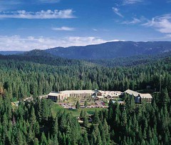
The popularity of geocaching– a high-tech scavenger hunt conducted using handheld GPS units– is not likely to be a surprise to readers of the Really Rocket Science blog. But the AP has an interesting report on how a lodge in Yosemite National Park is capitalizing on the sports’ popularity to bring visitors to its luxurious surroundings:


 [T]he Tenaya Lodge, just outside Yosemite National Park near Wawona, began offering a geocaching program along with its nature hikes and horseback riding outings last year….

Built 15 years ago and renovated recently, the 244-room Tenaya Lodge is the grandest of Yosemite’s perimeter "gateway" hotels catering to the park’s overflow and visitors who prefer to put a little distance between themselves and Yosemite Valley’s bustle….

Essentially, the sport is a cross between orienteering and a treasure hunt using high-tech navigation. Someone hides a "cache" – typically a plastic or metal bucket with a lid – with a logbook and some goodies in it and publishes the precise latitude and longitude on the Web. The goal is to dial those coordinates into your handheld GPS unit and have it lead you to the stash.

Since the sport began in 2000, it has grown exponentially. According to Geocaching.com, there are currently 202,735 caches in 218 countries…..

When I switched on the unit, it locked onto four satellites in geostationary orbit – meaning they appear to hover over one point on the globe – and spat out our elevation (5,288 feet) and our exact location (37 degrees, 26.402 minutes by 119 degrees, 36.237 minutes.) Depending on how well it linked up with the satellites, it was accurate to anywhere from 25 to 100 feet. With various "waypoints" pre-programmed, the GPS unit directed my wife, Jeri, and me down a series of increasingly rough dirt roads – the last was four-wheel-drive territory _ and beeped to alert me at various junctions. Or at least it was supposed to. The hotel is still working the kinks out of the system.

Read the full report on the author’s geocaching adventure in Yosemite here.


GPS for Gangs

Monday, May 8th, 2006

It works for finding lost pets and kids out past curfew, so it makes perfect sense to use GPS in fighting crime. I’ll be interested to see how California’s plan to track gang members using GPS works out.

 Under an arrangement between prison officials and San Bernardino, high-risk parolees known to belong to street gangs will be released from custody on the condition that they wear a GPS bracelet on their ankles at all times.

They appear as moving dots on a map and if they try to remove the anklet or enter unauthorized areas the device sends an alert to a base station monitored by law enforcement officials. 

I suppose it’s nothing new. According to the article, it’s already used by some California counties to monitor sex offenders. But when you combine that story with the ability to track wandering teenagers (or spouses) via GPS, it starts to sound like an episode of Wild Kingdom. It’s just that the tag is on a tasteful bracelet instead of being fastened to an ear. 

One question arises in my mind, however. How secure is this tracking system? In the cases of people who might be subject to retaliation or other attacks if identified — like sex offenders and gang memvers — how easy would it be for someone with enough technical knowledge, and an intent to do harm, to hone in on their tracking device and  locate them?

GPS Tracking for Parents

Thursday, April 13th, 2006

Before I had a kid of my own, I used to shake my head at parents who used "tethers," that looked like old fashioned telephone cords, to keep their toddlers from toddling off in public. Three years into parenthood, I haven’t succumbed to the "urge to tether" yet, but I’m a little less judgmental about the whole thing.

I have enough trouble keeping up with my three-year-old now. I’m already wondering how I’m going to keep up with him when he’s a teenager with enough subway fare to go where he wants. The answer is simple than I thought: GPS. If it can help find lost pets, it ought to work with kids too. So, though my little one isn’t big enough for a cell phone yet, I was relieved to read on Mobile Wireless News that Sprint just rolled a GPS-driven kid locator service for parents.

Using the Global Positioning System, the service allows parents to track up to four cell phones over the Internet or on their own wireless device. Parents can periodically ask the service to find the child’s phone, displaying the location on a road map.

Parents can also set alerts, automatically warning the parent if the child isn’t at a certain place, such as school or soccer practice, at a specific time.

The child’s phone also displays a text message, letting the child know they’ve been searched for and found.

Of course, there are other uses, like keeping track of elderly parents (as the article notes) or keeping tabs on a wandering spouse, which leads to charges that Big Brother is in the house.  I guess there’s two sides to every technology, and whether it’s used benevolently or not depends on whose pushing the buttons. But, as a parent, if kids can’t remember to be in the house when the streetlights come on, this seems like a pretty good way to remind them, when yelling down the street isn’t an option.