Archive for the ‘Space Business’ Category

EGOGRAM 2007

Wednesday, January 31st, 2007

Friends, Earthlings, ETs — lend me your sensory organs!

I send you greetings and good wishes at the beginning of another year. I’ll be celebrating (?) my 90th birthday in December – a few weeks after the Space Age completes its first half century.

When the late and unlamented Soviet Union launched Sputnik 1 on 4 October 1957, it took only about five minutes for the world to realise what had happened. And although I had been writing and speaking about space travel for years, the moment is still frozen in my own memory: I was in Barcelona attending the 8th International Astronautical Congress. We had retired to our hotel rooms after a busy day of presentations when the news broke — I was awakened by reporters seeking comments on the Soviet feat. Our theories and speculations had become reality!

Notwithstanding the remarkable accomplishments during the past 50 years, I believe that the Golden Age of space travel is still ahead of us. Before the current decade is out, fee-paying passengers will be experiencing sub-orbital flights aboard privately funded passenger vehicles, built by a new generation of engineer-entrepreneurs with an unstoppable passion for space (I’m hoping I could still make such a journey myself). And over the next 50 years, thousands of people will gain access to the orbital realm – and then, to the Moon and beyond.

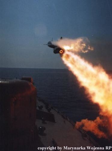
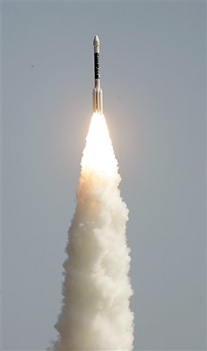
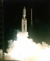
During 2006, I followed with interest the emergence of this new breed of ‘Citizen Astronauts’ and private space enterprise. I am very encouraged by the wide-spread acceptance of the Space Elevator, which can make space transport cheap and affordable to ordinary people. This daring engineering concept, which I popularised in The Fountains of Paradise (1978), is now taken very seriously, with space agencies and entrepreneurs investing money and effort in developing prototypes. A dozen of these parties competed for the NASA-sponsored, US$ 150,000 X Prize Cup which took place in October 2006 at the Las Cruces International Airport, New Mexico.

The Arthur Clarke Foundation continues to recognise and cheer-lead men and women who blaze new trails to space. A few days before the X Prize Cup competition, my old friend Walter Cronkite received the Foundation’s Lifetime Achievement Award. I have known Walter for over half a century, and my commentary with him during the heady days of the Apollo Moon landings now belong to another era. A space ‘pathfinder’ of the Twenty First Century, Bob Bigelow, was presented the Arthur C. Clarke Innovator Award for his work in the development of space habitats. With the successful launch of Bigelow Aerospace’s Genesis 1, Bob is leading the way for private individuals willing to advance space exploration with minimum reliance on government programmes.

Meanwhile, planning and fund raising work continued for the Arthur C. Clarke Center "to Investigate the Reach and Impact of Human
Imagination", to be set up in partnership with the University of Nevada, Las Vegas. Objective: to identify young people with robust imagination, to help their parents and teachers make the most of that talent, and to accord imagination as much regard as high academic grades in the classroom – anywhere in the world.  The Board members of the Clarke Foundation, led by its indefatigable Chairman Tedson Meyers, have taken on the challenge of raising US$ 70 million for this project. I’m hopeful that the billion dollar communications satellite industry I founded 60 years ago with my Wireless World  paper (October 1945), for which I received the astronomical sum of £15, will be partners in this endeavour.

I’ve only been able to make a few encouraging noises from the sidelines for these and other worthy projects as I’m now very limited in time and energy owing to Post Polio. But I’m happy to report that my health remains stable, and I’m in no discomfort or pain. Being completely wheel-chaired helps to concentrate on my reading and writing – which I can once again engage in, with the second cataract operation restoring my eyesight.

During the year, I wrote a number of short articles, book reviews and commentaries for a variety of print and online outlets. I also did a few carefully chosen media interviews, and filmed several video greetings to important scientific or literary gatherings in different parts of the world.

I was particularly glad to find a co-author to complete my last novel, The Last Theorem, which remained half-written for a couple of years. I had mapped out the entire story, but then found I didn’t have the energy to work on the balance text. Accomplished American writer Frederik Pohl has now taken up the challenge. Meanwhile, co-author Stephen Baxter has completed First-born, the third novel in our collaborative Time Odyssey series, to be published in 2007.

Members of my adopted family — Hector, Valerie, Cherene, Tamara and Melinda Ekanayake — are keeping well. Hector has been looking after me since 1956, and with his wife Valerie, has made a home for me at 25, Barnes Place, Colombo. Hector continued to rebuild the diving operation that was wiped out by the Indian Ocean Tsunami of December 2004. Sri Lanka’s tourist sector, still recovering from the mega-disaster, weathered a further crisis as the long-drawn civil conflict ignited again after more than three years of relative peace and quiet. I remain hopeful that a lasting solution would be worked out by the various national and international players engaged in the peace process.

I’m still missing and mourning my beloved Chihuahua Pepsi, who left us more than a year ago. I’ve just heard that dogs aren’t allowed in Heaven, so I’m not going there.

Brother Fred, Chris Howse, Angie Edwards and Navam Tambayah look after my affairs in England. My agents David Higham Associates and Scovil, Chichak & Galen Literary Agency deal with rapacious editors and media executives. They both follow my general directive: No reasonable offer will even be considered.

I am well supported by my staff and take this opportunity to thank them all:
Executive Officer: Nalaka Gunawardene
Personal Assistant: Rohan De Silva
Secretary: Dottie Weerasooriya
Valets: Titus, Saman, Chandra, Sunil
Drivers: Lalith & Anthony
Domestic Staff: Kesavan, Jayasiri & Mallika
Gardener: Jagath

Let me end with an extract from my tribute to Star Trek on its 40th anniversary – this message is more relevant today than when the series first aired in the heady days of Apollo: “Appearing at such a time in human history, Star Trek popularised much more than the vision of a space-faring civilisation. In episode after episode, it promoted the then unpopular ideals of tolerance for differing cultures and respect for life in all forms – without preaching, and always with a saving sense of humour.”

Colombo, Sri Lanka
28 January 2007


DIY Friday: Build Your Own GPS Navigation System

Friday, November 17th, 2006

Well, I know I’m a horrible driver, but my friends tell me I’m pretty decent with directions, so on long road-trips I’m usually the "navigator." In addition to my excellent map reading skills, knowledge of the compass rose, and keen sense of direction, I’m also pretty good at announcing where we should be turning, staying straight, or getting off the highway — oh my god, you just missed that exit. How could you have missed it? — just a few seconds before the necessary maneuver.
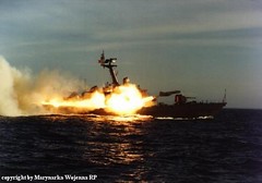
Still, while I may be pretty good at my shotgun role, I’m probably not nearly as a good as a device dedicated solely to the task. That’s why, even if you can’t afford one of those fancier devices or always have that navigating, right-hand man at your stead, you could always assemble a GPS navigating system yourself. Although the task isn’t too difficult, we found instructions over a navigadget for turning your Dell X50 palm PC into a lean, mean navigating machine with the help of a wireless bluetooth GPS a receiver and a little know-how.

And, although this might not be the most off the wall DIY Friday, just remember to thank us when you cut the time to Grandma’s house next Thursday with a little help from RRS, we’re smaller that that navigating buddy of yours and certainly require far less pit stops.

Delta Launch From The Cape

Wednesday, November 15th, 2006

Watch a Delta II launch the GPS Block 2R military navigation satellite on Thursday, 16 November. Live feed from the Kennedy Space Center

Here’s the latest from Spaceflight Now:

WEDNESDAY, NOVEMBER 15, 2006
2230 GMT (5:30 p.m. EST)

Preparations continue for tomorrow’s launch of the Boeing Delta 2 rocket carrying a replacement satellite for the Global Positioning System, but bad weather at Cape Canaveral is threatening to delay the liftoff. Launch will be possible between 2:17 and 2:30 p.m. EST (1917-1930 GMT).

A cold front will be sliding through Central Florida on Thursday, and Air Force forecasters expect the Cape to feel the brunt of the stormy weather between 3 and 11 a.m. A severe weather watch has been issued.

Gradual clearing is predicted later in the day, but rain, lingering thunderstorms and thick clouds still pose a high concern for the mid-afternoon launch. There is a 70 percent chance that conditions will be unacceptable at liftoff time.

Mission managers will meet before dawn to assess the latest weather outlook and determine if it’s safe to retract the mobile service tower from around the rocket at pad 17A. Winds cannot exceed 39 knots for the move, plus officials must be confident of no hazardous weather looming on the horizon that could harm the rocket while it stands exposed on the pad for the final hours of the countdown.

Tower rollback is targeted to occur around 6 a.m. The retraction could be postponed a couple of hours without impacting the launch time.

Air Force officials say their strategy, assuming weather is safe enough to retract the tower, will be pressing forward with the launch opportunity. An early decision to scrub is unlikely unless the launch time forecast gives absolutely no hope of allowable conditions, they said. As of right now, there is that 30 percent chance that the storms will clear in time.

The outlook for Friday is beautiful, forecasters say.


Get Lost?

Monday, November 13th, 2006

The Chicago Sun Times reports on a new first along the "Miracle Mile":

If you’re lost on Michigan Avenue, stop in the new Garmin store, and you won’t stay lost for long.

Billed as the world’s first GPS-only store, Garmin, the leader in the U.S. GPS market, on Saturday is opening a two-story, 10,000-square-foot store at 663 N. Michigan, featuring GPS devices for cars, fitness, camping and boating that tap into satellite signals to tell users how to get where they want to go…

[Spokesman Ted Gartner] said Garmin’s products typically are sold in electronics superstores, such as Best Buy and Circuit City, and online at Amazon.com. But, he said, "Our GPS units in stores typically are under glass. In the Garmin store, people will be able to handle them and see how they work…."

The Garmin store was designed by Chicago-based Valerio Dewalt Train Associates Inc. A 30-foot wood wall that runs around the entire store is a dominant feature.

Is this a link to GPS’s heritage as manufacturer of devices used to help outdoors types find their way?

Architect Joe Valerio said the design is intended to be ambiguous. He said the wood "reminds you of the walls of a canyon. Or is it the hull of a boat? Or the fender of a car? It is intentionally mysterious."

The backdrop contrasts with the precision of Garmin products, which, he said, "use GPS technology to make our world much less mysterious and much more understandable."

While the Garmin store in Chicago is the first GPS-only store of its kind in the world, others would dispute that GPS makes the world "less mysterious" and "more understandable." Computing Which? magazine recently conducted a study comparing the use of GPS and traditional road atlases for navigating the cold streets of the UK:

The ‘good old-fashioned’ £8 AA map-book not only beat a sophisticated £220 sat-nav system – costing nearly 28 times more and getting the driver lost down "obscure" country detours – it also knocked the socks off a computer-based route-finder costing £45.

The low-tech road atlas also trounced the Government’s own free online ‘Transport Direct’ website, which was by far the worst, giving motorists incorrect directions, sending them miles out of their way and taking users twice as long to get to their destination.

The findings follow a series of high-profile cases in which motorists – following their in-car sat-nav systems – have found themselves diverted along obscure and unsuitable roads, stuck in fords, rivers, or impassibly narrow lanes.

Even easier, as my wife constantly reminds me, is to stop at the next gas station and ask. But homey don’t play that.

Speaking GPS navigation in cars,  the Central Valley Business Times reports on one way that you shouldn’t use GPS if you’re a car rental agency:

Fox Rent A Car really knew where you were. And charged for it, the state of California says.

The largest California-based independent car rental company illegally slapped surcharges on those who traveled outside a three-state area and unlawfully forced customers to buy liability insurance, according to California Attorney General Bill Lockyer.

How did it know where its customers were driving? The state says it tracked its cars with GPS (Global Positioning Satellite) devices.

Fox paid nearly $750,000 in damages and penalties to settle the consumer privacy case. It would have been cheaper to throw in an atlas.

Saab, Polish Navy Ink Surface to Surface Missile Deal

Monday, October 9th, 2006

Defense Industry Daily reports that Saab will be delivering RBS15 surface-to-surface missles — which use a combination of radar and GPS guidance to deliver stealth attacks — to the Polish Navy:

 On October 6, 2006, Saab Bofors Dynamics and the Polish companies MESKO and BUMAR signed a contract for production of the RBS15 Mk3 anti-ship missile. MESKO and BUMAR are procuring the RBS15 Mk3 on behalf of the Polish Ministry of Defence, and the contract value is EUR 110 million (about $140 million). The ordered missiles will arm Poland’s Project 660 Orkan Class corvettes, which are currently part of a broad fleet modernization effort via a 2001 upgrade contract with Thales Naval Netherlands. The RBS15 Mk3 is currently in service with Sweden and Germany (via partner Diehl BGT Defence in September 2005); Poland is the second NATO country to adopt it….

RBS-15 fire-and-forget missiles grew out of Sweden’s need for missiles that excelled in littoral warfare situations like Sweden’s fractured coastlines and innumerable bays. They have a longer reach and heavier punch than counterparts like the USA’s Harpoon, with a range up to 200 km (120 miles) but a weight of 800 kg (1,750 pounds) and corresponding size. A set of rocket boosters are used to launch the missiles, after which they use their turbojets until target impact. They can be fired from ships, land vehicles, or aircraft to hit ships or land targets as required, using a combination of radar and GPS guidance during an stealthy, terrain-hugging approach that includes programming for indirect attack vectors, evasive maneuvers, and re-attacks. Additional features like salvo launch, which allows several missiles to arrive at the same target simultaneously from different directions, increase the missile’s lethality.

The SAAB press release can be found here


Launch Day Monday — Delta II: Good; SpaceLoft XL1: Almost.

Tuesday, September 26th, 2006
Watched the Delta II launch a GPS payload yesterday, live on HD-Net. Gorgeous launch on a beautiful day at Cape Canaveral Air Force Station in Florida. Seeing it in HDTV does make a difference.

Boeing’s workhouse did its job:

The Delta II rocket carrying the GPS IIR-15 (M) spacecraft lifted off from Space Launch Complex 17A at Cape Canaveral Air Force Station, Fla., at 2:50 p.m. EDT, Sept. 24. Following a nominal 68-minute flight, the rocket deployed the satellite to a transfer orbit.

The Boeing Delta II 7925-9.5 configuration vehicle used for today’s mission featured a Boeing first stage booster powered by a Pratt & Whitney Rocketdyne RS-27A main engine and nine Alliant Techsystems (ATK) solid rocket boosters. An Aerojet AJ10-118K engine powered the storable propellant restartable second stage. A Thiokol Star-48B solid rocket motor propelled the third stage prior to spacecraft deployment. The rocket also flew with a nine-and-a-half-foot-diameter Boeing payload fairing.

Monday’s other launch event, at Spaceport America in New Mexico, did not do as well. The SpaceLoft XL1 rocket failed at around 40,000 feet, eliciting this gem of a quote from launch logistical coordinator Tracey Larson:

"If it was easy, everyone would be doing it."

GPS for Pets

Thursday, August 31st, 2006

I’ve been accused of being a crazy cat lady from time to time, and I can live with that. And I have a penchant for tech toys and all things geek. So it figures that I would come across this new product while surfing.

A company called Petsmobility, Inc. says they plan to release a GPS cell phone for dogs:

Measuring approximately 5 cms wide, 2.5 cms thick and 9.4 cms long, the PetsCell™ sets the standard for GPS tracking devices for pets. Unlike any other ‘Rush to Market’ products currently available. The PetsCell™ utilizes the new CDMA / GPS tracking technology, rather than the current GSM technology. This technology is so new, PetsMobility is the first company to be provisioned by network providers to use this technology in the (LBS) pet industry.

I don’t know if I like this idea or not. I guess it can work but…calling my pet’s cell phone? Using GPS to track where my dog has been all day?


Disney Dumps Kid Tracking Service

Wednesday, August 16th, 2006

I’ve been following the trend of mobile companies offering GPS tracking to families for a while now, starting with Sprint’s announcement of its service back in April, and Verizon’s launch of its “chaperone service.” Now it looks like competition is heating up in that market, as I just came across the first announcement I’ve seen of a company getting out of the business. Disney is dropping its mobile tracking service.

Disney has shelved plans to launch a mobile virtual network operator in the U.K., saying the market is in flux.

The media giant had been planning to launch its family friendly mobile virtual network operator (MVNO) this year, piggybacking on wireless provider O2’s network. Now Disney has changed its mind, putting the plan on ice indefinitely.

A Disney spokeswoman said the decision had been made as a result of “the rapidly changing competitive environment.”

“Retail distribution outlets in particular have consolidated in recent weeks, which has impacted our distribution opportunities,” she added.

Apparently, Disney’s experience with market saturation in the U.S. influenced its decision in the UK. But the company is keeping an eye on the market, and may revisit offering its tracking service to customers in the UK.

Blast from the Past: Titan IV

Tuesday, August 1st, 2006

Titan IV

We reached into our video archives and pulled out two rocket launches to show you. Titan IV is the largest unmanned space booster used by the U.S. Air Force to carry payloads as big as the ones the space shuttle carries.

On September 8, 2003, Communications Concepts, Inc. broadcast the launch of the massive Titan IV as it blasted off the launch pad at Cape Canaveral Launch Complex 40. The day’s payload was a satellite for the National Reconnaissance Office. The model rocket was the Titan IV-B, the final model of the now retired Titan program, which was the largest, most powerful, heavy-lift expendable launch vehicle in the United States at the time. This mammoth rocket was as tall as a 20-story building and, with the solid rocket boosters and fuel, weighed about 940,000 kilograms (2 million pounds). In the video, you can see the sheer power of the Titan as the shot, captured from a remote camera less than 500 feet from the launch pad, fills with white just after liftoff.


License (Plate) to Track

Thursday, July 27th, 2006

She may not be real, but I’ve got some advice for that girl Emily. If really want to keep track of a straying spouse, track his license plate.

PlateFinder

Jealous lovers may soon have an alternative to sniffing for perfume to catch a cheating mate: Just follow their license plate.

In recent years, police around the country have started to use powerful infrared cameras to read plates and catch carjackers and ticket scofflaws. But the technology will soon migrate into the private sector, and morph into a tool for tracking individual motorists’ movements, says former policeman Andy Bucholz, who’s on the board of Virginia-based G2 Tactics, a manufacturer of the technology.

Bucholz, who designed some of the first mobile license plate reading, or LPR, equipment, gave a presentation at the 2006 National Institute of Justice conference here last week laying out a vision of the future in which LPR does everything from helping insurance companies find missing cars to letting retail chains chart customer migrations. It could also let a nosy citizen with enough cash find out if the mayor is having an affair, he says.

Or it could let a suspicious spouse find out if the other half is stepping out.

Just one more step in the tracking of everything and everyone. But wouldn’t this be easier with GPS? After all, it works for lost dogs, gang members.

Emily could just get her husband a new phone, say from Sprint or Verizon, but that might make him suspicious. (Then again, a billboard is pretty big tip-off.) But chances are he already has a mobile phone and, as I noted earlier, anyone with a mobile phone can be located and tracked. Next time she wants to hit the joint banking account to send a message to Steven, Emily might consider signing on with AccuTracking, World-Tracker, or U-Locate. The more subtle and probably also cheaper than putting up billboards across the country.