Archive for the ‘Space Business’ Category

Qualcomm Wins U.S. Contract to Track Mexican Trucks

Wednesday, November 14th, 2007


"Qualcomm has won a federal contract to provide a satellite-based tracking system for U.S. and Mexican trucks participating in a contentious experiment that opens the border to long-haul commercial traffic," SignOn San Diego reports:

Federal officials said yesterday that the San Diego-based company’s OmniTRACS system will allow the U.S. government to closely monitor trucks from both countries, including compliance with regulations that prohibit truckers from driving more than 11 hours per day.

Although Qualcomm is best-known for its prominent role as a chip-maker in the wireless industry, the company also is a major designer of satellite tracking systems for vehicles.

Qualcomm will provide tracking technology for 100 trucks at a cost of $367,000, officials said.

U.S. transportation officials hope the tracking system will soften congressional opposition to the two-month-old pilot project. Five carriers from Mexico and three from the United States are participating in the program, which is limited to a maximum of 100 carriers from each country.

OmniTRACS uses geosynchronous satellites and "helps fleets improve productivity, reduce operating costs, enhance customer service, and increase security." Features include:

    * Automatic satellite vehicle positioning
    * Two-way text and data communications
    * Highly reliable message delivery
    * Customizable reports
    * AS/400, Windows®, or web-hosted operation
    * Panic Buttons (available option) 

We’re not sure what the Panic Button achieves, but we assume it won’t be ignored like the car alarms that bleet plaintively in our local mall parking lot. 

Qualcomm has a nice flash demo of OmniTracks here. The system predates commercial use of GPS, and its next iteration — OmniVision — will provide real-time directions and maps using Maptuit’s NaviGo to truckers on the move:

Maptuit NaviGo is a real-time, hybrid  in-cab navigation service that provides professional truck drivers and trucking companies with interactive maps for increased routing efficiency and improved driver satisfaction.  QUALCOMM plans to offer NaviGo on the OmniVision platform later this year….

The OmniVision mobile computing platform is an integrated system consisting of hardware, software and network infrastructure, enabling delivery of two-way data communications and value-added services to enterprises in a mobile environment.


Malagasy Cup Uses Satcom to Stay Connected

Friday, October 26th, 2007

We recognize the what cup? might be your first response to the title of this post. What is this, as Rocco asked, a geography lesson?

Well, sort of. Malagasy, of course, refers to Madagascar, and the Malagasy Cup is a race from Anakao to Andavadoaka “for traditional Malagasy vessels, boutry and pirogue/lakarna vezo…. with dozens of vessels making the 200 kilometre journey in five stages stopping at: Tulear; Ifaty; Salary; Ambatamilo and finally Andavadoaka.”

Anakoa looks particularly inviting to us on this gray rainy East Coast of America day:

Vizada is helping the general public follow the race:

 New video satellite communications will make it possible for the general public to follow the five stages of the Malagasy Cup…  occurring along the Madagascar Coast. This is because Vizada (formerly FTMSC) and Satellite Air Time will manage the race communications as well as communicate photos and videos from these remote areas. The BGAN (Broadband Global Area Network) service will allow journalists to follow the race as well as to send video and photo reports from the race’s five, staging point villages. The BGAN laptop sized satellite terminal uses high-speed Internet connections of up to 492 kbps to send large volume of data in areas that lack mainstream telecom networks.

Iridium satphones will allow competitors and organizers the ability to stay in permanent contact with the capital city, Antananarivo, as 200 canoes and 30 dhows cross the staring line of the Malagasy Cup. This is a 200 km race along the world’s third largest reef in southwest Madagascar and offers a unique opportunity to showcase the traditional sailing boats of the Vezo “people of the sea” as well as the preserved landscape of this area of the world.

Vizada is also a reseller of aeronautical satcom services from Inmarsat; two days ago, they announced the release of Swiftbroadband, which is “Inmarsat’s first fully IP-based, high-speed data service offering broadband in-flight connectivity including both cockpit communications and cabin applications.”

But back to Madagascar. Among its many fascinating natural wonders are lemurs; check out this video on YouTube to experience them firsthand.

Good Morning, Delta!

Tuesday, October 16th, 2007


I love the smell of hydrochloric acid in the morning! That’s what you get when you mix rocket fuel burn-off with the air around the launch pad.

A Delta II rocket will be the sight to see Wednesday morning at the Cape Canaveral Air Force Station (webcast). The details, courtesy of United Launch Alliance:

Rocket/Payload: Delta II launching the U.S. Air Force’s Global Positioning System (GPS) IIR-17M satellite.

Date/Launch Time/Site: Oct. 17, with a launch window of 8:23 – 8:38 a.m. EDT from Space Launch Complex-17A, Cape Canaveral Air Force Station, Fla. If the launch slips, the next launch attempt is set for Oct. 18, 8:19 – 8:34 a.m. EDT.

Description: GPS IIR-17 (M) will be the fourth modernized NAVSTAR Global Positioning System (GPS) military navigation satellite to launch. GPS is a space-based radio-positioning system consisting of a minimum of 24-satellite constellation that provides navigation and timing information to military and civilian users worldwide.

Launch Updates: To keep up to speed with updates to the launch countdown, dial the ULA launch hotline at 1-877-852-4321.

Satellite Feeds:
Test Signal Start Date/Time: 10/17/2007 07:45:00 EASTERN
Program Start Date/Time 10/17/2007 8:00:00 EASTERN
End Date/Time: 10/17/2007 10:00:00 EASTERN

Downlink: Galaxy 26
Transponder – G26C-09
ORBITAL POSITION: 93 DEGREES (W)
BAND-C ANALOG
BANDWIDTH 36 MHz
DOWNLINK FREQ 3880 MHz (V)

All launches from the Cape are supported by the 45th Space Wing, Patrick Air Force Base — and people like Chris Bruce, who was featured in nice piece by Patrick Peterson in Florida Today:

When Chris Bruce isn’t keeping his 19-year-old daughter’s car running, he’s using his considerable mechanical ability to lead the team of technicians preparing the third stage of Delta 2 rockets for launch.

The GPS IIR-17 launch from Complex 17A on Wednesday morning will be the latest of nearly 50 rockets on which the 45-year-old Mims resident has worked.

Weighing 4,540 pounds, the satellite will be the fourth to feature newer GPS technology. It will be able to provide more accurate navigation data for pilots, drivers, boaters, hikers and the military.

Working conditions are tough. The good-natured
ribbing between his colleagues at United Launch Alliance, who also are his golfing buddies, often rises to a level of nastiness that only the thick-skinned and steel-nerved can bear.

There is one consolation.

"What goes around comes around," he said, showing a good-natured grin. "What you’ve dished out the day before, you’re receiving the next day."

The constant needling and trading of verbal jabs keeps the crew on their toes, he added. Oddly, it also makes for a good work environment.

"We’re like a second family," he said. "It’s like hanging out with your brothers."

Long hours at work are required during crunch times, and Bruce’s boss depends on him to make sure people and parts are where they should be.

"He leads with his experience," said Robin Smith, an assembly and test manager with 37 years of aerospace experience. "And I do count on him and rely on him a lot."

Bruce’s easygoing personality makes him a good co-worker.

"He’s very good natured," Smith said.

Bruce is among about 4,000 United Launch Alliance employees who launch government satellites for the company formed by a merger of the rocket divisions of Lockheed Martin Corp. and The Boeing Co. in May 2005.

His crew assembles the launcher’s third stage, which is about six feet tall and will push the GPS satellite to its final orbit about 11,000 miles above Earth. The spacecraft will become one of 30 GPS satellites in orbit.

"We’ve been really good about putting them right where they need to be," Bruce said.

Bruce came to Brevard County 22 years ago, after completing a two-year associate’s degree in electronics at DeVry University in Atlanta.

"I had an uncle who worked for McDonnell Douglas. He got me an interview, and the rest is history," he said.

After several job changes, including working as a roofer for a year during a slowdown, Bruce started working on the Delta program in 1996.

If successful, this GPS launch would be the 77th Delta launch since the last failure in 1997. Consistency has been a hallmark of the program.

"There have been very few changes since I’ve been in this group," Bruce said. "It’s basic, but it’s efficient."

Bruce said the experienced crew is comfortable processing the rocket’s third stage because they have done the job many times before.

"It’s just like clockwork," he said. "Everything gets bolted and torqued. We’ve done it so much, we just know."

Bruce said attention to detail and the determination to do a good job are the personality traits that make his group successful.

"It was the way I was brought up," he said. "My dad always had the philosophy, ‘If you’re going to do it, do it right the first time. Put forth your best effort.’ "

"It’s the whole group. It has to be right," he said. "There’s no room for error."

During Wednesday’s launch, Bruce will follow the countdown even though he doesn’t work with the launch crew.

"I really don’t worry," he said. "I know the system is reliable and it always has been."

Using Satellites to Study Whales

Wednesday, October 10th, 2007

For decades, Japan’s scientific whaling program has killed thousands of whales as part of what it calls necessary research.

Needless to say, Japan’s whaling program has been a point of contention with the environmental group Greenpeace for just as long.

Now, however, Greenpeace is leading the fight against whaling a different way — by example:

Greenpeace announced a satellite-based tracking system to monitor endangered South Pacific humpback whales, saying it is not necessary to kill the animals as Japan does to study them…

Humpback whales from Rarotonga and New Caledonia have been satellite tagged and are "now being tracked in order to produce vital data on their movements, habitat use and population structure," said Greenpeace New Zealand’s oceans campaigner, Mike Hagler.

"The tagging program is producing real scientific results" on whale migrations from breeding grounds in the South Pacific to feeding grounds of the Southern Ocean "without firing a single harpoon," he said.

Tracking whale migration is critical to developing plans and policies to preserve the species; satellite tracking is a natural solution to the problem of tracking big mammals in an even bigger ocean. Whalenet has a good description of how satellite tracking works for whales:

  WhaleNet uses satellite transmitters that send signals to satellites maintained by the ARGOS System in Largo, Maryland and Talouse, France. A number of the U.S. National Oceanographic and Atmospheric Administration’s (NOAA) weather satellites, circling the earth, have ARGOS instruments attached. These instruments collect, process and disseminate environmental data relayed from fixed and mobile transmitters worldwide. What makes ARGOS’s system unique is the ability to geographically locate the source of the data anywhere on the Earth.

Data is collected by the tag while the marine animal is underwater and then transmitted when the animal surfaces. The tag has an antennae which is used to send a signal each time the animal surfaces. Information relayed includes time, date, latitude, longitude, dive depths, dive durations, amount of time at the surface in the last six hours and quality of the transmission. The ARGOS instruments detect the tag’s signal when the satellite passes overhead.

The location fix of the animal in relationship to the track of the satellites, with ARGOS instruments, affects how many satellites passes are made over the animal’s tag in a 24 hour period. Each pass may last between 2 and 12 minutes, depending on the location of the satellite in relation to the animal. The animal must be at the surface at the time of the pass for a successful transmission to take place. Therefore, each day there are a limited number of short opportunities, or maybe no opportunities, for a signal to be transmitted from an animal’s tag to a satellite.

How are they attached?

 With whales the tag is attached by partially implanting a barb into the blubber layer at a slight angle, to a depth of approximately 10 cm. Ideally it is placed high on the back of the whale, directly behind the blow hole. These tags are deployed using a compound crossbow. A study by the Minerals Management Society determined that this does not cause serious stress or pose a health risk to the whale. The tagging team goes out in a 4 meter rigid-hull inflatable equipped with an outboard motor in order to get close enough to the whale to implant the tag.

There’s no relation, we hear, between the satellite tracking of whales and the chip implants for your pet.


Taxi!

Monday, August 27th, 2007

We’ve written before about plans to use satellite tracking technology to follow the progress of New York City Transit buses.

No one seemed to complain about that idea, since being able to see exactly where the bus you’re waiting for is on its route is of undeniable benefit to the riders, and at worst makes no difference to a bus driver.


But a plan to put GPS in New York City taxis has cabbies screaming and honking like — well, like New York City cabbies:

The New York Taxi Workers Alliance — which accounts for more than 8,000 city drivers — is threatening to curb their cabs on Sept. 5 if the Taxi and Limousine Commission does not get rid of their GPS system, which the union says invades a driver’s privacy….

The issue over a driver’s privacy is the driving issue in the debate, with a driver’s location being tracked no matter where he or she goes.

"The Taxi & Limousine Commission wants to spy on drivers and they want drivers to pay for it," argues Desai.

Both sides agree the TLC uses satellite GPS technology to track everywhere a taxi cab goes and keeps a log of that information. The dispute is over how that information will be used and just who will have access to it.

Mateo says it’s understandable that the taxis are fitted with the technology and adds it’s even advantageous to each driver. "It indicates where you’re located, you can see where you’re going," he says.

But Desai says there is a different motive for the TLC to install the satellite. "They will use this information to decide on drivers’ incomes," she says.

Sources within the TLC and individual taxi drivers tell CBS 2 that the GPS fears have nothing to do with privacy and everything to do with money. Many drivers fear the IRS will use the data to audit drivers and alert the INS about illegal immigrants driving cabs.

Could this be the first strike ever started by GPS? 

Ukraine Announces New Space Program

Thursday, August 2nd, 2007

Politically, Ukraine is somewhat at a cross-roads, being pulled in one direction by its Russian-Soviet past and in the other direction by its Western EU-NATO neighbors. The 2004 "Orange revolution," which discarded the Kremlin’s favoured candidate, may have been the turning point.

Ukraine’s space program reflects Russia’s declining influence. First it was Ukraine’s agreement to participate in EU’s Galileo System (a system similar to GPS), not joining Russia’s developing Glonass system.

Now, Ukraine has announced an ambitious new 4-year independent space program. An English translation of a Ukranian news report explains:

The Cabinet of Ministers today at the session has affirmed the national target scientific and technical space program of Ukraine for 2008-2012. General Director of National space agency Yuriy Alekseev told journalists.

According to him, financing of the State program amounts UAH 1,5 milliard.

According to the program, in particular, Ukraine should launch two satellites of remote sensing of the Earth, to create a satellite of connection and to participate in tenders of satellites creation for the other countries.

“The satellite has been already made for Egypt, and in autumn it can be given to the customer,” Alekseev noted.

Also, according to Alekseev, the program foresees the training of Ukrainian specialists at the European space enterprises, “UNIAN” reports.

Russia’s WPS news agency (subscription only) has more on the satellites:

Two of the satellites are intended for remote Earth probing and the third is a communication satellite. General Director of the National Space Agency, Yury Alexeev, announced this after approval of the draft space program of the country for the next five years at a meeting of the government. The document makes provisions for active international cooperation including cooperation with Russia, European Union and the US. The costs of the program exceed $400 million and state financing will account for about $300 million of this amount.

Rubidium Clock Marks Year In Orbit

Tuesday, May 22nd, 2007

Physorg reports on the rubidium clocks being tested for ESA’s Galileo satellite system, which, when fully deployed in the early years of the next decade, will be the first civilian positioning system to offer global coverage:

GIOVE-A, the first Galileo in-orbit validation element, was launched on 28 December 2005. One of its two rubidium clocks was switched on for the first time on 10 January 2006 and Galileo signals were transmitted two days later.

The timekeeping of the clocks on the Galileo spacecraft will play an important role in determining the overall accuracy of the system, so evaluation of their performance is a crucial part of the Galileo in-orbit verification process.

The orbit of GIOVE-A is precisely measured by a network of 10 ground-based laser ranging stations, to provide orbital data independent of the navigation data. The navigation signals broadcast from GIOVE-A, and from the GPS spacecraft constellation, are received by the world-wide network of 13 Galileo experimental sensor stations belonging to the GIOVE Mission Segment.

The technique used to characterise clock performance is known as Orbit Determination and Time Synchronisation (ODTS). ODTS is a statistical method which takes the Galileo and GPS data, together with the laser ranging data, and calculates spacecraft orbits, clock times, the effects of the Earth’s atmosphere on the radio signals and the delays in the receiving systems. The precision of the calculations is so great that even the tiny orbit disturbances caused by the pressure of sunlight shining on the satellites is taken into account…. 

The measured performance of the clocks meets the specification over short and medium timescales. A few ‘jumps’ in clock frequency have been observed, which impact the long term accuracy. Such frequency changes are a well known phenomenon in rubidium clock technology but their cause is not yet well understood. Their effect on GPS performance has already been analysed and corrective measures proposed. The Galileo team are ground testing a number of improvements to the clock design which are intended to minimise both the occurrence and size of the jumps. 

(It ain’t pretty, but it’s accurate!)

The ESA website offers further explanation about the accuracy of the rubidium clock:

The Galileo satellites will carry two types of clocks: Rubidium atomic clocks and Hydrogen atomic clocks. The stability of the Rubidium clock is so good that it would lose only 3 seconds in 1 million years, while the Hydrogen maser is even more stable and it would lose only 1 second in 3 million years. However this kind of stability is really needed since an error of only a few nanoseconds (billionths of a second) on the Galileo measurements would produce a positioning error of meters which would not be acceptable.

For those who really want to get into the complexities of such atomic clocks, check out this page from Harvard’s Department of Physics. In addition to details about the frequencies used by atomic masers (hey, no one said this wasn’t rocket science!) the page features a downloadable poster illustrating N-resonances and atomic clocks.

The Great Turtle Race!

Tuesday, April 17th, 2007

Here’s a great story about how the combination of satellite tracking technology and the Internet can be used to raise awareness about conservation efforts around the world.

The Leatherback Sea Turtle is the biggest of all living turtles and the world’s fourth-largest reptile, reaching more than 6 feet in length and weighing up to 2000 lbs. It is also listed as endangered worldwide by the U.S. government, with the global population of female leatherbacks plunging from an estimated 115,000 in 1980 to fewer than 43,000 today.

Ranging throughout the Pacific, Atlantic and Indian oceans, leatherbacks worldwide are threatened not only by coastal development and loss of habitat, but by ocean pollution and "floating plastic bags or sheets which they mistake for jellyfish — a staple of their diet." 90 percent of the leatherbacks have vanished and the species may disappear within 10 years due to illegal poaching of their eggs, according to conservationists.

To draw attention to the plight of the leatherbacks, conservationists yesterday launched the Great Turtle Race.

The AP reports:

Biologists will switch on satellite trackers strapped to the backs of 11 female leatherback turtles on Monday, starting what conservationists have dubbed the "Great Turtle Race" to raise awareness of a species threatened with extinction.

Sponsored by U.S. and Costa Rican environmental groups and businesses, the race will track the turtles on their annual 1,200 mile journey from Costa Rica’s Pacific coast to the Galapagos Islands….

Most of the competing turtles are expected to be in the water by Monday after laying their eggs on the beach at Playa Grande in Costa Rica.

The Web site features virtual trading cards with caricatures of the turtles with names like Freedom, Windy and Stephanie Colburtle after U.S. comedian Stephen Colbert of Comedy Central fame. It also has stats on their egg-laying history…

Ten race sponsors — including Yahoo Inc., Plantronics Inc., Philadelphia’s Drexel University and Dreyer’s Ice Cream — donated $25,000 each to purchase the tracking equipment and protect nesting areas from development.

Leatherbacks aren’t the only sea creatures that are getting tagged with satellite trackers to raise awareness and scientific knowledge about  the world’s oceans. The Census of Marine Life has a great site, Tagging of Pacific Pelagics, where users can track tracking projects of a variety of species and view real time data of the movement of sharks and other animals in the Pacific. And NASA is tracking sea lions to gain a better understanding of the world’s oceans.

For ease of use and entertaining presentation — especially for a younger audience — it’s hard to beat the Great Turtle Race website. Check it  out, because those turtles are, um, making some quick tracks.

Boring Press Releases

Sunday, February 25th, 2007

I’m so glad we have journalists around to make the news interesting. Imagine if we only had press releases.  B-O-R-I-N-G !

Just look at all these releases surrounding the Satellite 2007 show in Washington last week. Open your eyes wide and read these exciting excerpts:

"…released two new software options to their industry leading product lines that extend their already unique ability to…"

"This flexibility makes the product line more accessible to the networking requirements of government, military, and commercial customers who increasingly value high uplink and downlink speeds at a node and desire to blend terrestrial solutions with their satellite backhaul."

"The company’s DVB-RCS/S2 solutions are the only multiple-access satellite solutions capable of delivering data transfer rates of up to 80 Mbps for downloads and up to 8 Mbps for uploads at each remote terminal, or enough bandwidth to support a variety of users such as a small business or battalion unit to an entire community/military base from a single remote terminal."

And this quote is typical from apparently happy customers:

“We are looking forward to working with X on the development of this next generation intelligent network. Significant improvements can be made to future VSAT systems with the addition of artificial intelligence to the network. These capabilities offer the promise of enhanced performance and economic gains which will allow us to offer new and more cost effective services to our customers.”

I think it’s time we put some excitement in our "realeases" and start making some real news. I’ve noticed NASA’s public affairs people are putting some fun into their work and coming up with some very creative angles over the past year or so — just take a look at this "Camping on the Moon" release. Brilliant!

Ed’s “What’s Next?” Speech

Tuesday, February 20th, 2007

SES AMERICOM CEO Ed Horowitz was the guest speaker at the Washington Space Business Roundtable’s Flagship Lunch and Silent Auction on Tuesday, 20 February 2007.

We don’t have a podcast or video available, so here’s the text of the speech:

“What’s Next?”

I appreciate this chance to speak with you today in this beautiful new facility. Not long ago, as many of you remember, this spot was part of a run down community — which has obviously been brought back to life.

It’s changed.

And — in the midst of the good change around us, I feel it is appropriate to ask, “What’s Next” for our  business and for us?

Where will we be in 20 years?

Will we be in 20 years?

I subscribe to Stanford’s “Growth Theory” economist Paul Romer’s view that growth occurs whenever people take resources and rearrange them in ways that are more valuable”.

To know what is “more valuable” is a matter of vision.

At the Twenty-second Communist Party Congress in 1961, Soviet Premier Nikita
Khrushchev’s vision was that within 20 years the Soviet Union would out-produce the United States in all the traditional sectors of industrial might — coal, steel, cement, fertilizer and so on.

In 1981, that vision was indeed fulfilled: that year the Soviet Union outdid America in every one of those industries.

They successfully reproduced a late 19th, century manufacturing based industrial economy…while the US was inventing a 21st Century chip, computer and information based economy.

A new world happened, shaped by a furious and unplanned burst of technological, cultural and economic force. 

The Soviet vision of the future was as over-confident, but more importantly it was simply — over.

Nikita Khrushchev saw the future through the wrong end of a telescope where the moment seemed larger than it was — and the horizon smaller. He believed he could outwit history with a good plan built on dedicated incrementalism which had one gear — sideways.

As we meet today and at other conferences persistently speaking —to each other —my fear is that we might be inclined to use Nikita’s telescope to envision what’s next for us.

The satellite industry, including SES, has dictated broad global changes in other businesses from entertainment to defense; from detection and GPS to secure communication.

Today, the satellite business is producing reliable earnings for our shareholders. But undeniably, there are changes on the horizon dictated, if nothing else, by the changing worlds of our customers…. And they expect us to “get it”. They expect us to anticipate needs.

What the future holds is an exciting mystery. But, we are better off addressing possibilities while we have a chance to invest in them; to own them —-rather than to ignore or possibly be displaced by them. That’s what we will talk about today.

What we know is that the future will be vastly different.

It is estimated that within the next 25 years, science and technology will advance by a factor of 4 – 7x beyond the advancements over the last 25 years.

While we may hear this in stride — it is absolutely stunning in its business and social implications.

It means that where we stand today on the technology and science scale versus where we will be in the next 25 years — is a moment equivalent to being in the year 1650.

Think about it …1650!

Of course the 25 years from 1650 – 1675 saw their own dramatic developments. The English started drinking tea. Cromwell dissolved Parliament, and the first bank note was issued in Sweden.

During this time the world population expanded to 500 million, which is about one-third the size of India today.

Isaac Newton began experiments with gravity and Cheddar Cheese was invented.

The great Plague of London commenced and the English settled in Charlestown, Virginia.

Ice cream was invented and La Grand Vetel, a famous French chef killed himself because Louis the 14th didn’t like the dinner La Grand had prepared.

You could say a lot happened in those 25 Years…But, the world had seen nothing yet.

1650 was 225 years before the phone was invented and…a century and a half before the ratification of the US Constitution.

It was 200 years before Edison was born.  It was 200 years before the US population would reach 23 million and China’s population then — was almost the same number as China Mobile’s cellular customers today (about 350 million).

1650 was 307 years before Sputnik and 315 years before the first satellite.

We are all familiar with the advances made in the satellite industry through compression. Well, get ready for the advances in history made by an unprecedented compression of knowledge in the next 25 years.

We’re about to enter “The Great Compression”.

We are looking at the equivalent change of the last 315 years — about to be compressed into the next 25 years.

What does this mean?

It means — for example — that if you are in the transportation business — the worst four words you could imagine for your business — may actually be heard in the next 25 years…The four words? — “Beam me up Scotty”.

The odds that the massive changes coming in the “Great Compression” will leave the satellite industry untouched — are zero. Change will come to us whatever we choose to do or not to do.

What will we be doing when it comes?

While technology is a “business”, it is also a force not to be controlled even by the best of intentions.

The genie is out of the bottle and the question is whether the genie is working for us or are we working for the genie?

Let’s spend a little time today on some broad issues of concern to our industry and to our customers:

1. U.S. Government business…

2. The commercial and media business…

3. The ramifications of change in both worlds and lastly …

4. I want to discuss a looming talent deficit as we face the  coming “Great Compression”.

The US government business is, as you all know, changing rapidly. Saddam Hussein invaded Kuwait in August, 1990 and the US and Coalition forces liberated it in January of 1991.

During the 5 ½ months between Hussein’s invasion and ours, the American military was caught without the satellite capacity to track and mount the offensive.

They scrambled to acquire the needed transponders and didn’t have time for emergency appropriations to acquire them, so the costs were guaranteed —- by Private Citizen Ted Turner.

It was no coincidence that Turner’s CNN had the best and for a time the only video from Desert Storm.

The US military will never be caught like that again. Six months after our troops landed, DISA was created to make sure it wouldn’t happen again.

In the intervening years between Desert Storm and 9/11, the US military changed. 

When 9/11 came, the military was ready with a system in place to fund $78 million dollars worth of contracts to provide the satellite and communications services needed. The contracts were in large part for bundled solutions in addition to the broadband commodity.

We learned then that in the future we need to leverage what only satellites can provide — advanced mobile communications and high speed internet access — while on the move —-anywhere in the world — via aircraft, boat, humvee or on foot.

What the military needs is megabytes, not megahertz. The military expects a ground and mobile capacity consistently capable of facial recognition.

Increasingly, the US government wants net-centric bundled solutions as well as broadband and they are calling upon us to be creative about it.

There is a demand for specific megabyte capacity per war fighter and we also know that this demand will only grow over time.

Increasing our military business means persistently increasing capacity and solutions.

For example, there is an ever expanding need for video teleconference capability (VTC) — for commanders in the field, in Washington, and for soldiers on the ground.

The invasion of Iraq was witnessed live on multiple screens in the White House Situation Room. Decisions could be made in real time with real data. Before that it was almost like Abraham Lincoln waiting for a telegram telling him that Grant had taken Richmond.

Soldiers on the ground also have growing “human terrain” needs in addition to VTC — also things like  IM and secure chat capability.

Remember, in five years … 50% of the military will be Gen X and Y. They grew up in a digital world. The military has to grow with them – and so do we.

Whenever we speak of high speed mobile communications we must, in the same breath, speak of advanced development of “in-orbit” flexibility and new antennae development.

Satellites must increasingly have capabilities for re-direction and re-programming in space.

We must advance efforts to change frequencies and footprints in orbit.

We look over our shoulders for our competitors and can’t see some of them because they’re in front of us. They may not even be in our business.

For example, let’s look for a moment at the world of Nano-technology, once viewed as science fiction, but today may represent the “key enabling technology” of the 21st century.

Nano- technology is the “purposeful creation, manipulation and use of matter, physical structures and engineered devices with previously unimaginable dimensions”.

Nano-technology is starting to impact chemistry, biology, applied physics and medicine. The inevitable applications to the space and satellite world are just beginning to be imagined.

But, one way to think of it, knowing that a nanometer is one billionth of a meter, is to see every person as a nano-unit in a world with six billion people. That is the level of services and connection we must contemplate.

What are some of the ramifications of these great changes for our customers and for our business?

One ramification could be friction with our current customers and we have to think about that.

Many of our major customers are in the commercial media world — where things are also changing at a furious pace.

You Tube, MP3, file sharing and a host of  other technological and social changes are threatening old business models like “Beam me up Scotty” would threaten transportation.

Our media customers are losing control of their customers who are increasingly less dependent on mass packaged media which we reliably deliver.

User generated and niche media (nano media) are replacing mass media.

Remember the 1998 Jim Carrey movie, “The Truman Show” where an unsuspecting insurance salesman’s life was made into a 24/7 movie for the entertainment of the town’s people?

Everyone in his fabricated town, his mother included, made a fool of him everyday — in their controlled entertainment world.

It was all run out of a network studio from which Truman eventually escaped– heartbroken.

Now think of The Truman Show in reverse where the insurance salesman watches everyone and anyone all day and all night, as he chooses.

Imagine control gone from the entertainment business into the hands of Truman… and the walls of the entertainment and media world come tumbling down.

That’s where we’re headed — along with our customers. User generated content and demand is going to turn the media world upside down.

Control will shift and it will be a new challenge to make an honest buck for the old institutions.

What is the response of the media and entertainment business to this creative destruction threat?

A recent book called “Wikinomics” – gives one example of how the media world is responding in the field of music… and I quote:

“Rather than embracing MP3 and adopting new business models, the industry has adopted a defensive posture. Obsession with control, piracy, and proprietary standards on the part of large industry players has only served to further alienate and anger music listeners…If your invention can be replicated at no cost, why should anyone pay?…Today a new economic model of intellectual property is prevailing”.

What is our response?

In the commercial and media world, let’s look at two business prospects on extreme ends of the continuum.

On one end, is the real prospect for business in the under and un-developed world. Half the world does not participate in the global economy in any way shape or form.

The developed world is increasingly understanding the value of changing this through governmental, private and NGO enterprises. It is not strictly a charitable exercise but a way to grow demand and markets.

The economy cannot be called global until this succeeds on a much greater scale. Central to these prospects are enterprises within our expertise. The sooner undeveloped countries have access to the information and communication revolution which, in many ways we can steer, the sooner there will be unprecedented growth and demand not evident in mature economies.

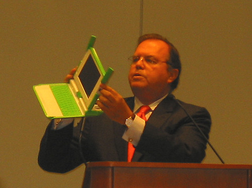
An example of how we extend the reach into being  called “truly global” may be characterized by SES’ support of One Laptop Per Child (OLPC) Initiative.

OLPC is designed to put into the hands of children around the world the capacity of accessing information and connectivity with others ranging from people in their village or nearby villages, anywhere in their country and potentially around the world.

On the other end of the continuum are the possibilities in the media world with the disruption of old models.

But before we go any further, let’s make something clear. When we say “user generated content” we all think of You Tube or something like it. But You Tube makes no money and never has — except for its original creators who profited handsomely when they sold to Google. 

When Google purchased You Tube and was asked how they intended to monetize it, the answer was: “we’ll figure that out later.”

Let’s be honest. You tube content is dominated by really, really bad material —and the most frequently viewed material inclines toward quality production and content.

But, as you have seen, Viacom is now demanding that You Tube remove all of its Viacom material. Others will surely follow. And You Tube’s offerings will begin to diminish.

Then there is Current TV, Vice President Gore’s effort, which is totally user-generated content. But it’s still part of the standard Dish and cable mass media package.

It’s user-generated content but it’s still part of the old business model for the system providers.

From our point of view, the revolution may have little to do with user generated content and everything to do with user “dictated” content.

I’m talking about free enterprise — for real.

Very recently, an outfit called Virtual Digital Cable in Illinois, has started a service to deliver cable programming without cable — by using only the internet.  No trench digging or coaxial cable or fibre placement… no local franchise or fees. Naturally,
the legal challenges to VDC are blocks long but the point is Disruption for our customers and for us — is inevitable.

Product development and innovative bundled Solutions like IP Prime are important targets. But how do we most effectively and most profitably adapt to the new net-centric content world?

One answer is to consider what I called “My Geosynchronous Media” but someone told me that MGM was taken. Then I tried “My TV” but of course, MTV was taken. So for now let’s just call it “My TV Station”.  “MTVS”

MTVS is a niche media for one; a nano niche.

It is the creation of a net-centric and net- neutral, trusted third party content aggregator designed as “My TV Station” which runs exactly what you want, when you want it on whatever device you choose.

The customer pays only for the exact content they want… whether it’s sports or Friends re-runs, all CSI or whatever. MTVS delivers it and pays the content provider — as a trusted 3rd party must.

Unlike cable and traditional satellite mass programming where you pay for things you never watch, MTVS gathers exactly and only what one person wants to watch when they want to watch it.

This direction means we would become a “Relationship Management” business in addition to our conventional business.

It also means we would, to an unavoidable extent, be in competition with our current customers.

Does that matter? Of course it does. But, these are the kinds of questions we need to face now before it’s too late to do anything about it.

My last issue is “People”. Are the Human resources and talent out there? Can we keep what we have and get what we need? What about the Demographic Wall?

Business Week Magazine recently advised new professionals to stay away from the space business because it offered “no future”. The engineering and science expertise that is the fundament of our industry is aging and this means on one hand that many are near retirement with a thin bench of possible replacement.

On the other hand, those who choose to stay in the business, and we need them desperately,  are making it hard for new people we do attract to move up —- and also difficult to make change.

The truth is that as we move forward, this is not your “Father’s Satellite” world.

When it comes to attracting talent, you could say, we have an image problem natural to a maturing industry and …we have an advancement opportunity problem for the ambitious new engineer we do attract.

It is the science and invention that makes us grow. There is a clear shortage on the horizon.  It is also true that as an industry, we have very poor public communication and we tell no exciting stories which we need to attract talent.

Just as the American military will be 50% composed of X and Y Gen soldiers who grew up in a digital world, my fondest hope for our industry is that we can say the same. If we can’t –then the future will be a lot harder to face.

I have shared some things to think about with you today and I appreciate your listening to them. I’m glad to hear your ideas as well — any time.

But for now, I see my time is up so I guess all I can say is Thank You and…“Beam Me Up — Frank ”.

Thank you very much.