Archive for September, 2008

3 Billion New Internet Users on the Way?

Tuesday, September 9th, 2008

A start-up company, backed by some big names, is seeking to add 3 Billion new Internet users from poor, remote countries.

On Tuesday, O3b Networks Ltd., founded and run by 38-year-old telecommunications entrepreneur Greg Wyler, is expected to announce plans to launch as many as 16 satellites that could provide service to Africa, the Middle East and parts of Latin America by the end of 2010.

The undertaking, expected to cost about $650 million, has initial backing of about $60 million from investors that include HSBC Holdings PLC, Allen & Company, and Liberty Global Inc., in addition to Google.

Of course, the blogs are abuzz with the news that Google is launching 16 new satellites, especially after yesterday’s post about the GeoEye-1, but Google is only anteing up $20 million for the project.

The bigger news is about O3b, whose young CEO, Greg Wyler, has pulled together an impressive list of funders to tackle a very lofty goal.

This isn’t the first time that Wyler has launched an aggressive project to bring Internet access to the developing world. He also paired up with the Rwandan government in an effort to connect schools, government institutions and homes with low-cost, high-speed Internet service. The fate of that project contains some warnings for this venture. Rwandan officials say Wyler didn’t follow through on his promises:

Wyler says he sees things differently and that he and the Rwandan officials will probably never agree on why their joint venture has been so slow to get off the ground. But Terracom’s tale is more than a story about a business dispute in Rwanda. It is also emblematic of what can happen when good intentions run into the technical, political and business realities of Africa.

The technology behind the latest venture is a low-earth orbit system, built by Thales Alenia Space.

Side Note: O3b is headquartered in St. John, Jersey, Channel Islands. Never heard of it? Officially the "Bailiwick of Jersey”, it’s located in the English Channel, off the coast of France.
Google Maps is about to get even better

Monday, September 8th, 2008


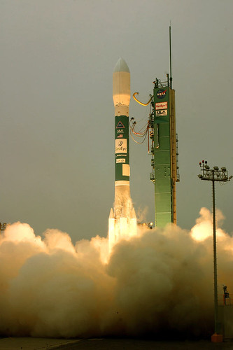
The GeoEye-1 satellite – the world’s highest resolution, commercial Earth-imaging satellite – was launched on Saturday.

You’ll soon be able to check out the satellite’s images for yourself:

ars technica In return for undisclosed terms, Google got two considerations: its logo on the side of the launch vehicle, and exclusive use of the mapping images that the satellite produces.

The satellite maker, General Dynamics Advanced Information Systems, says the GeoEye-1 cost $500 Million to build and launch and its imaging services could be sold for anything from environmental mapping to agriculture and defense. Funding for the project came from commercial satellite company GeoEye and the Defense Department’s National Geospacial-Intelligence Agency


DIY Friday: break the sound barrier?

Friday, September 5th, 2008

Yeah, pretty wild, right? Thanks to our friends at MAKE, it isn’t all that hard to create a sonic boom. The device is called a Bullwhip, but let’s just call it a “sound barrier breaking machine” – sounds more impressive.

Space Junk

Friday, September 5th, 2008

The more missions we undertake and the more satellites that launch into orbit, the more space "junk" that we’re inevitably left with. And we’re tracking much of it:

The U.S. Strategic Command maintains a catalogue currently containing about 13,000 objects, in part to prevent misinterpretation as hostile missiles. Observation data gathered by a number of ground based radar facilities and telescopes as well as by a space based telescope[6] is used to maintain this catalogue. Nevertheless, the majority of debris objects remain unobserved. There are more than 600,000 objects larger than 1 cm in orbit (according to the ESA Meteoroid and Space Debris Terrestrial Environment Reference, the MASTER-2005 model).

Now much of this debris can be tracked in realtime via Google Earth. Pretty cool.

"With the recent discussion of the ISS having to dodge some space junk, many people’s attention has once again focused on the amount of stuff in orbit around our planet. What many people don’t know is that USSTRATCOM tracks and publishes a list of over 13,000 objects that they currently monitor, including active/retired satellites and debris. This data is meaningless to most people, but thanks to Analytical Graphics, it has now been made accessible free of charge to anyone with a copy of Google Earth. By grabbing the KMZ, you can not only view all objects tracked in real-time, but you can also click on them to get more information on the specific satellite, including viewing it’s orbit trajectory. It’s an excellent educational tool for the space-curious. Disclaimer: I not only work for Analytical Graphics, but I’m the one that wrote this tool as a demo."

The U.S. Strategic Command tracks the junk mainly to prevent misinterpretation as hostile missiles; Google Earth does it mainly to offer another cool tool for nerds like myself to play with. But whatever our tracking purpose, one commenter on Slashdot may have the cure to all of our debris woes:

…we should put a black hole in orbit to take care of the debris. we can name it Hoover.

Sat-Phone Totin’ Cowboys

Tuesday, September 2nd, 2008

Home on the range is going high-tech.

The Bureau of Land Management is distributing satellite phones to cowboys working in areas prone to wildfires. The cowboys, who are often out of cell range, are the first line of defense for communities vulnerable to sudden fires.

The BLM says Owyhee County [Idaho]…is the first place the agency has armed cowboys with satellite phones…For an initial agency investment of $10,000, the seven Iridium satellite phones seemed a reasonable bargain, said Janet Peterson, the BLM’s safety manager in Boise — especially considering that 1,000-square-mile complex alone cost more than $13 million to fight and will likely set taxpayers back $34 million more to restore the blackened landscape.

Iridium has nearly 230,000 commercial and government voice subscribers, along with a unit that supplies equipment for companies and the U.S. Department of Defense to track assets in remote areas where there’s no conventional cellular communication. Voice users include soldiers, the maritime industry, oil and gas companies, utilities, construction and mining — "Basically any industry where you’ve got workers out in the middle of nowhere," Iridium spokeswoman Liz DeCastro said.

Angola’s Drive to Satcom

Monday, September 1st, 2008


It’s official, according to the Angola Press Office:

O Governo oficializou, mediante publicação no Diário da República de 15  de Julho último, o projecto de criação do satélite angolano "Angosat", integrando a sua produção, lançamento e operação.

A resolução inserida na I Série, nº 130 deste órgão oficial, a que a Angop teve acesso, refere que o projecto inclui também a criação de recursos humanos e infra-estruturas.

O referido diploma aprova igualmente os contratos de empreitada referentes à construção, colocação em órbita e operação do satélite Angosat, celebrado entre o Ministério dos Correios e Telecomunicações e a Empresa Federal Unitária Estatal "Rosoboronexport", em representação do consórcio de empresas russas, no valor de 327 600 000.00 dólares.

O projecto tem em consideração que as características do território nacional, em especial a sua dimensão e densidade populacional, aliadas a necessidade de harmonização do crescimento económico, mesmo nas zonas mais recônditas do país, torna necessária uma infra-estrutura de telecomunicações via satélite a curto e médio prazos.

Tem ainda em conta a necessidade crescente de recursos de transmissão incluindo por satélite, face ao engajamento do Estado angolano na criação de condições que tornem o país um membro activo da sociedade da informação através da utilização crescente das tecnologias de informação que requerem banda larga.


Thank you, Red Orbit, for the efficient translation:

The government of Angola has formalized, through an announcement in the State Gazette of last 15 July, the project of creating the Angolan satellite dubbed "Angosat", including its production, launch and operation.

Angop learnt on Saturday [23 August], from decision included in the First Series No 130 of this official organ, that the project also includes the creation of human resources and infrastructures.

The referred document also approves the contracts for the construction, placing in orbit and operation of the Angosat satellite, signed between the Ministry of Post Office and Telecommunication and the state-run federal unit firm "Rosoboronexport", in representation of the consortium of Russian companies, estimated at 327.6m US dollars.

The project takes into consideration that the characteristics of the national territory, especially its dimension and population density, linked to the need of harmonizing the economic growth, even in the most remote zones of the country, demands a short- and mid- term satellite telecommunication infrastructure.

It also takes into account the growing demand for resources of transmission by satellite, due to the Angolan state’s engagement in the creation of conditions that turn the country into an active member of the information society through the growing use of information technologies that demand broad band system.


Petro dollars can help rocket science prosper almost anywhere.