Posts Tagged ‘s-band’

Excited Cesium Atoms and the Radio Antenna

Wednesday, September 19th, 2018

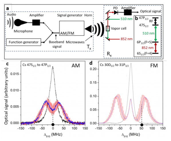
Fascinating read about an atomic receiver for AM and FM radio communication, able to operate from the C- to the Q-bands, which may someday bring quantum physics into the world of satcom receivers.

Here’s more from MIT Technology Review

The secret sauce in the new device is Rydberg atoms. These are cesium atoms in which the outer electrons are so excited that they orbit the nucleus at great distance. At these distances, the electrons’ potential energy levels are extremely closely spaced, and this gives them special properties. Indeed, any small electric field can nudge them from one level to another.

Radio waves consist of alternating electric fields that readily interact with any Rydberg atoms they come across. This makes them potential sensors.

But how to detect this interaction? A gas made of Rydberg atoms has another property that turns out to be useful—it can be made transparent by a laser tuned to a specific frequency. This laser essentially saturates the gas’s ability to absorb light, allowing another laser beam to pass through it.

However, the critical frequency at which this happens depends crucially on the properties of the Rydberg atoms in the gas. When these atoms interact with radio waves, the critical frequency changes in response.

That’s the basis of the radio detection. Anderson and co create a gas of cesium atoms excited into Rydberg states. They then use a laser tuned to a specific frequency to make the gas transparent.

Finally, they shine a second laser through the gas and measure how much light is absorbed, to see how the transparency varies with ambient radio waves.

The signal from a simple light-sensitive photodiode then reveals the way the radio signals are frequency modulated or amplitude modulated.

And that’s it: an antenna consisting of a cloud of excited cesium atoms, zapped by laser light that flickers in time to any ambient radio waves. They call it atomic radio.

Very cool — and no electromagnetic interference!

Inmarsat’s Relevancy

Tuesday, March 25th, 2014

Inmarsat’s been around since 1979, operating geosynchronous communications spacecraft using the S-band. Compared to the GPS system, not overly glamorous. In the maritime satcom market, they’re the biggest fish in the pond.

With the current attention focused on how this old satellite company using standard physics to help locate the lost Malaysian airliner, they should become better known.

They’re on it, mate.

Here’s the story in The Malaysian Insider

Britain’s Inmarsat used a wave phenomenon discovered in the 19th century to analyse the seven pings its satellite picked up fromMalaysia Airlines Flight MH370 to determine its final destination.

The new findings led Malaysian Prime Minister Najib Razak to conclude on Monday that the Boeing 777, which disappeared more than two weeks ago, crashed thousands of miles away in the southern Indian Ocean, killing all 239 people on board.

The pings, automatically transmitted every hour from the aircraft after the rest of its communications systems had stopped, indicated it continued flying for hours after it disappeared from its flight path from Kuala Lumpur to Beijing.

From the time the signals took to reach the satellite and the angle of elevation, Inmarsat was able to provide two arcs, one north and one south that the aircraft could have taken.

Inmarsat’s scientists then interrogated the faint pings using a technique based on the Doppler effect, which describes how a wave changes frequency relative to the movement of an observer, in this case the satellite, a spokesman said.

The Doppler effect is why the sound of a police car siren changes as it approaches and then overtakes an observer.

Britain’s Air Accidents Investigation Branch was also involved in the analysis.

“We then took the data we had from the aircraft and plotted it against the two tracks, and it came out as following the southern track,” Jonathan Sinnatt, head of corporate communications at Inmarsat, said.

The company then compared its theoretical flight path with data received from Boeing 777s it knew had flown the same route, he said, and it matched exactly.

The findings were passed to another satellite company to check, he said, before being released to investigators on Monday.

The paucity of data – only faint pings received by a single satellite every hour or so – meant techniques like triangulation using a number of satellites or GPS (Global Positioning System) could not be used to determine the aircraft’s flight path.

They did a fine job with their corporate video, too. Standard concept of a “timeline” script, yet executed brilliantly.