Brazilian Observation Satellite Launched by Chinese



There are a lot of happy rocket scientists in Brazil today: 

CBERS-2B é lançado com sucesso da base chinesa de Taiyuan 

Exatamente às 00h26min desta quarta-feira (19) foi lançado com sucesso o CBERS-2B, terceiro satélite da parceria entre Brasil e China. O evento foi comemorado tanto no Centro de Controle de Satélites do INPE, em São José dos Campos (SP), como no Centro de Lançamento de Satélites de Taiyuan. O diretor do INPE, Gilberto Câmara, assistiu ao lançamento na base chinesa e, junto com os engenheiros Ricardo Cartaxo e Jânio Kono, respectivamente coordenador geral e coordenador do Segmento Espacial do Programa CBERS, transmitiu todas as informações aos técnicos e convidados que acompanharam da sede do Instituto.

“É uma emoção muito grande. É o resultado de um grande trabalho feito por brasileiros e chineses. Estamos todos muito orgulhosos”, disse o diretor Gilberto Câmara.

Chefe do Centro de Controle de Satélites do INPE, Pawel Rosenfeld manteve contato constante com Jânio Kono, coordenador do Segmento Espacial do Programa CBERS, que da base comandou as operações junto com os técnicos chineses.

O foguete Longa Marcha 4B cumpriu perfeitamente todas as etapas previstas para colocação do satélite em órbita. O tempo total de vôo até a injeção do CBERS em órbita foi de 12,5 minutos. O CBERS-2B é lançado com seus transmissores ligados permitindo assim que a estação de rastreio de Nanning, na China, mantenha contato com o satélite desde antes de sua separação do último estágio do veículo lançador, até aproximadamente um minuto e meio após a abertura dos painéis solares, que aconteceu cerca de 14 minutos após o lançamento.

The spacecraft is capable of producing images such as this beauty of Manaus:

Here’s the explanation, in English, via SpaceFlightNow.com:

A joint mission developed by China and Brazil was shot into an orbit circling Earth’s poles to snap detailed images of the globe during an early Wednesday launch from China’s northeastern space base.

A Long March 4B rocket launched with the international satellite at 0326 GMT Wednesday (11:26 p.m. EDT Tuesday) from the Taiyuan space center in China’s Shanxi province, according to the state-run Xinhua news agency.

The booster’s three liquid-fueled stages accurately deposited the third China-Brazil Earth Resources Satellite into a Sun-synchronous orbit about 12 minutes after liftoff.

CBERS 2B was left in a nearly circular orbit with an average altitude of approximately 462 miles, Xinhua reported. The Long March 4B was shooting for an orbital inclination of 98.5 degrees.

Wednesday’s launch marked the 60th consecutive success for China’s Long March rocket fleet. It was also the 8th space launch for China so far this year.

CBERS 2B will spend the next few weeks undergoing systems tests and preparations for an operational mission expected to last at least two years.

The 3,200-pound satellite was ordered by Chinese and Brazilian officials in 2004 to bridge the gap between older spacecraft and next-generation satellites, which should begin launching in 2009.

The craft’s predecessors, CBERS 1 and CBERS 2, were launched by Chinese rockets in 1999 and 2003, respectively. Both outlived their baselined two-year missions, according to Brazil’s National Institute for Space Research, a co-sponsor of the program.

The China Academy of Space Technology was in charge of the Chinese contribution to the mission, Xinhua reported.

CBERS 2B carries three primary imaging cameras to take a wide range of pictures of locations scattered throughout the world.

A low-resolution camera with a 60-degree field of view will specialize in capturing images of large swaths of the planet. Another camera will be capable of taking pictures with a resolution of about 65 feet.

Unlike its forerunners, CBERS 2B includes a high-resolution black-and-white camera able to produce images showing objects as small as 2.5 meters, or about eight feet. CBERS 1 and CBERS 2 each carried an infrared scanning instrument instead.

Scientists expect to use data from the project in environmental monitoring, crop planning and managing water resources. Images can also be used to identify types of vegetation and in soil surveys. Pictures could also end up in geography textbooks, according to Brazilian space officials.

Images from the new high-resolution camera will also be useful in urban planning and military intelligence applications for China and Brazil.

China has a 70 percent stake in the 19-year-old program, while Brazil controls about 30 percent of the project. Users in both nations have access to the satellite imagery.

Pictures from the spacecraft have been distributed online since 2004, and more than 15,000 users have downloaded about 320,000 images since the Internet campaign began, according to Brazilian officials.

Two more satellites with four cameras each will be launched in 2009 and 2011. The program extension was approved in 2002, and China and Brazil will equally split responsibility for the new project.
Here’s a video about the Brazilian Space Agency:

And here’s a little Brazilian space center tribute video set to Brazilian metal (mind the volume):



SeaMobile Testing VSAT Over Atlantic

We’ve written before about the growing market for maritime satcom for large ships. Now, SES NEW SKIES is teaming up with SeaMobile’s Maritime Telecommunications Network (MTN) product group for extensive field tests of new miniaturized VSAT antennas, which will enable an array of satellite-based communications services for small vessels:

SeaMobile and SES NEW SKIES will test two new 60cm VSAT antennas, that set new standards with respect to size and weight of VSAT installations: the heavy-duty “Ruggidized” for fishing, work boats and oceangoing support vessels, and the lighter “Sure Lock”, which at less than 90lbs addresses more specifically the sailing, yachting and power boat markets. Both antennas use iDirect Spread Spectrum technology, allowing for small-sized, lightweight antennas which are effectively shielded against adjacent satellite interference. SES NEW SKIES is providing Ku-band capacity for the Spread Spectrum Technology demonstrations on its NSS-7 satellite at the orbital location of 338° East….

States Scott Sprague, Senior Vice President Global Sales of SES NEW SKIES: “Small-sized and light-weight VSAT antennas open up completely new markets for small vessel broadband connectivity, be it for professional use, navigation support, safety services or pure leisure/entertainment. The SES NEW SKIES global satellite fleet is particularly well positioned to support communications on the move, be it maritime, land- or air-based.”


As you can see from this map, SeaMobile currently has extensive MTN satellite coverage, and they’ve just signed their first commercial shipping customer:

SeaMobile Enterprises, a provider of at-sea communications and connectivity, announced Tuesday that it has reached a service agreement with Global Marine Systems, an independent, undersea cable installation and maintenance company. Terms of the three-year contract were not disclosed. SeaMobile said it will provide its Maritime Telecommunications Network satellite services aboard three Global Marine vessels. SeaMobile said it has already installed its MTN VSAT satellite services on two of the ships and expects to address the third later this month. Global Marine Systems is based in Chelmsford, England. SeaMobile is headquartered in Seattle and provides broadband and satellite services for more than 300 maritime vessels.

Stratos has also recently entered the maritime satcom marketplace, while Schlumberger is working to build a model that integrates land and sea.  


Delta Launches WorldView-1

Google Earth users may soon be enjoying higher-resolution images of our little blue planet, thanks to yesterday’s launch of the Worldview 1 satellite.


The AP gives a summary: 

The WorldView 1 satellite, built for DigitalGlobe, which supplies much of Google Earth’s imagery, was lofted into space aboard a Delta 2 rocket [from Vandenberg Air Force Base]. The satellite separated from the rocket about an hour after liftoff and was circling 300 miles (480 kilometers) above Earth.

WorldView 1 was designed to collect up to 290,000 square miles’ (750,000 square kilometers’) worth of imagery a day — an area about the size of Texas. Information gathered by the 5,000-pound (2,270-kilogram) probe can be used by governments and companies to assess damage after a natural disaster or plan escape routes before a catastrophe, the company said.

Images and details about the bird can be found on the DigitalGlobe website. Features include an "ultra-stable platform, high-precision attitude sensors and GPS" that "allows the creation of accurate maps in remote areas, maximizing the utility of whatever resources are available," as well as the "highest commercially available" resolution, with direct downlink of those images available to customer sites using a high-speed 800 Mbps X-band downlink.


The Worldview 1 satellites was built by Ball Aerospace. Check out their online media kit, including high-resolution photos of the satellite.

Worldview 2, also being built by Ball Aerospace, is slated for completion in late 2008. 

Home Run Ball in Space

The guy who owns Barry Bonds’ record-breaking home run ball may send it into space. Voting ends on 25 September 2007:

I have my own opinion, I’ve been part of this debate just like everyone else. But I wanted to make it just a little more real. I bought this baseball to democratize the debate over what to do with it.

So what should we do with the ball? (A) Bestow it — Cooperstown; (B) Brand it — burn an asterisk into the ball, adding a permanent footnote to the record, then Cooperstown; or (C) Banish it — put the ball on a rocket ship and launch it inot orbit, a moon shot for the ages.


Alaska Airlines – another first?

If you’d ask a group of passengers if cell-phone calls should be allowed on flights, you would receive instant protest. No one wants to sit next to a chatterbox teenager or, worse, an angry business man with a bluetooth for a five hour flight. You ask about WiFi, however, and you would receive instant excitment. Emails, surfing, news, chatting — Americans want to be connected.

As the airline biz gets increasingly competitive, is inflight Internet access the next competitive edge? Alaska Airlines thinks so:

Alaska Airlines today announced it plans to launch inflight wireless Internet service next year based on Row 44’s satellite-based broadband connectivity solution. Alaska made the announcement in Toronto at the 28th Annual World Airline Entertainment Association Conference and Exhibition. The airline will test Row 44’s system on a next-generation Boeing 737 aircraft in spring 2008 and, based on the trial’s outcome, plans to equip its 114-aircraft fleet.

The technology will provide customers with a unique entertainment and business network at 35,000 feet. Passengers with Wi-Fi-enabled devices, such as laptop computers, PDAs, smartphones and portable gaming systems, will have high-speed access to the Internet, e-mail, virtual private networks and stored inflight entertainment content.

“Bringing broadband Internet access to the skies is one of the most important things we can do to enhance the experience of both business and leisure customers,” said Steve Jarvis, Alaska Airlines’ vice president of sales, marketing and customer experience. “We’re moving ahead with testing and ultimately plan to bring wireless broadband to our whole fleet.”

Unlike air-to-ground services, Row 44’s satellite-based system is designed to function over land, water and across international borders, enabling service throughout Alaska’s route system in Alaska, the Lower 48 states, Hawaii, Canada and Mexico.

Customers connect to the system through wireless hotspots installed inside the aircraft cabin. A light-weight radome mounted on top of the aircraft houses an antenna, which receives and transmits signals through the Ku-band satellite system.

Alaska plans to become the first US airline with such connectivity, although American and Virgin America are planning similar services through an air-to-ground platform provided by AirCell. Row 44’s system will rely on high-earth-orbit satellites, providing continuous coverage in remote areas and over water (it is Alaska Airlines, after all). Both systems can be easily installed in short sessions, lessening the aircraft down-time.

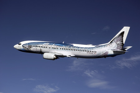
Alaska has a history of innovation. They were the first North American airline to offer online ticketing (1995) and online check-in (1999). Oh, and they paint salmon on some of their planes. Cool.

If history is our guide, similar in-flight Internet platforms will be picked up by other carriers in short-order. The WSJ (subcription-only) mentions that Southwest is considering the service. And the always active rumor-mill at Airliners.net is predicting a big JetBlue announcement in October (inflight Internet, perhaps?).


Sealand – a communications hub?

We’ve discussed a lot of important deployments of satellite Internet — developing nations, rural areas, and mobile platforms, to name a few. Let’s not forget about MicroNations:

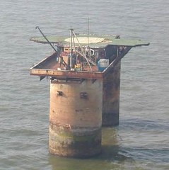
Sealand, a tiny ex-British military base used during WWII, sits just off the Southeast coast of England. Since the tiny platform has only a population of 20, no connections to mainland England, and, um, questionable international status, how does Sealand get wired?

From SatNews:

The Principality of Sealand has received a multi-million dollar investment opportunity from a Russian investment group to fund the launch of a new communications satellite. So states the official newspaper of the country, the Sealand News. Such a project would give the independent micro-nation total worldwide Internet freedom plus internationally un-restricted Internet broadcasting, all from the former military fortress/artificial island located six miles off the coast of Britain.

It’s no secret why Sealand would be an attractive communications hub — no taxes, no censorship, no restrictions. For example, Sealand will soon be launching an online casino, promising 100% tax-free winnings. There has also been talk of using Sealand as a hub for media download services.

Pirate Radio is on the list too. Sealand’s own newspaper has the details:

A new Pirate Radio Station is supposed to set up shop in Sealand.

History repeats itself as a group of young radio DJs are negotiating with the Principality over using the former British anti-aircraft platform as the location for their new “Free Radio Sealand”.

Plans are to use the facilities of HavenCo, the internet hosting company with its datacenter located in Sealand, to launch an international internet radio station as well as a terrestrial and digital radio station.

“We’re going to bring back Pirate Radio big time,” said Stuart Turner (21), also known as Lord Stuart of Sealand, a former Virgin Radio DJ. “We’re going back to the roots of Radio Essex when listening to the radio was actually a way of life!”

The Principality of Sealand used to be a Pirate Radio station in the early Sixties: During the summer of 1965 Roy Bates entered the Pirate Radio business and set up his own radio station at Knock John Tower, a former WW2 British naval defence platform in the Thames estuary.

An original wartime radio beacon was converted for use as the broadcasting transmitter and regular broadcasts commerced on 7 November 1965. The enormously popular Radio Essex, later renamed BBMS (Britain’s Better Music Station) was the first Pirate Radio Station to provide 24/7 entertainment and shaped the face of Sixties pop culture as we remember it.

After being convicted of violating British broadcasting law, Roy Bates moved his radio station to Roughs Tower. 2 years later Bates turned Roughs Tower into the Principality of Sealand and became HRH Prince Roy of Sealand!

KAGUYA Launches

In June, we discussed the naming of Japan’s new lunar study — what many consider the most sophisticated lunar exploration mission in the post-Apollo Era. It is also Japan’s first major lunar mission. Last Friday morning, the spacecraft launched from Tanegashima island, 600 miles south-west of Tokyo, aboard an H-2A solid-fuel rocket:

ScienceDaily has the project details:

The mission of the SELenological and ENgineering Explorer “KAGUYA” (SELENE), Japan’s first large lunar explorer, is being keenly anticipated by many countries.

The major objectives of the mission are to understand the Moon’s origin and evolution, and to observe the moon in various ways in order to utilize it in the future. The lunar missions that have been conducted so far have gathered a large amount of information on the Moon, but the mysteries of its origin and evolution have been left unsolved.

KAGUYA will investigate the entire moon in order to obtain information on its elemental and mineralogical composition, its geography, its surface and sub-surface structure, the remnant of its magnetic field, and its gravity field. The results are expected to lead to a better overall understanding of the Moon’s evolution.

At the same time, the observation equipment installed on the orbiting satellite will observe plasma, the electromagnetic field and high-energy particles. The data obtained in this way will be of great scientific importance for exploring the possibility of using the moon for human endeavors.

KAGUYA consists of the Main Orbiter and two small satellites (Relay Satellite and VRAD Satellite). The Main Orbiter will reach the vicinity of the Moon. Once it has reached the Moon, it will be placed into a peripolar orbit at an altitude of 100 km. The Relay Satellite will be placed in an elliptic orbit at an apogee of 2400 km, and will relay communications between the Main Orbiter and the ground station. The VRAD Satellite will play a significant role in measuring the gravitational field around the Moon. The Main Orbiter will be employed for about one year and will observe the entire Moon.

Is this the start of an Asian Space Race? The Guardian sees some evidence:

While Jaxa officials play down talk of a space race with China, the mission is a major step towards the goal of building a manned station on the moon by 2025, and a sign of renewed regional interest in lunar exploration. China is to send its Chang’e-1 probe to the moon this year to construct 3-D images of the moon’s surface and analyse its dust. India is expected to launch an unmanned lunar orbiter next year.

Google’s X-Prize

My senior year of High School I read the newly released book Longitude, which detailed the scientific quest for an accurate and durable method for determining longitude at sea. The prize: the equivalent of 12 million in today’s currency. I couldn’t help wonder why our scientific innovation wasn’t promoted in the same way. Sure, government and university grants are great for scientific progress but so is a little healthy competition and the prospect of massive wealth.

Imagine my excitment when I read about the X-Prize, announced at about the same time as the publication of Longitude. In 2004, the X Prize awarded its first prize of $10 million to Burt Rutan and Paul Allen for developing the first non-government, reusable manned spacecraft that was launced into space twice within two weeks.

The X-Prize Foundation lives, offering prizes for a number of contests from genome sequencing technology to building a 100-mpg vehicle.

Now, Google is getting into the game. The Google Lunar X-Prize will offer $20 million to the first team that constructs autonomous rovers that can land on the moon, travel at least three-tenths of a mile, and send video, images and data back to Earth. Google is running the project in conjunction with the X-Prize foundation. MSNBC has the details:

The first team to succeed would win $20 million – that is, if the job is done by 2012. After that, the prize drops to $15 million, and if no one is successful by the end of 2014, the money could be withdrawn. If a second team succeeds before the deadline, $5 million would be given as a runner-up prize. Another $5 million would be reserved for bonus tasks – for example, roving for longer distances, taking pictures of old lunar spacecraft, finding water ice or surviving the long lunar night.

The imagery and other data beamed back from the moon would be shared with the world via the Google Lunar X Prize’s Web site.

“By working with the Google team, we look forward to bringing this historic private space race into every home and classroom,” Peter Diamandis, chairman and chief executive officer of the California-based X Prize Foundation, said in a prepared statement. “We hope to ignite the imagination of children around the world.”

Watch the promotional video, find an extremely wealthy sponsor and some rocket scientists, then get to work, folks.

Nothing like reverting to early 18th Century contests to solve the technological challenges of the 21st Century and beyond.

DIY Friday: Burning Man

When you think of Burning Man, a six-day festival held in the middle of the Black Rock Desert in Nevada, you think of eccentric art—sculptures, paintings, artistic contraptions of all kind. Burning Man hits the limits of self-expression. Even more amazing, though, is Burning Man’s commitment to self-reliance. As one essayist puts it:

You’re here to survive. What happens to your brain and body when exposed to 107 degree heat, moisture wicking off your body and dehydrating you within minutes? You know and watch yourself. You drink water constantly and piss clear. You’ll want to reconsider drinking that alcohol (or taking those other substances) you brought with you — the mind-altering experience of Burning Man is its own drug. You slather yourself in sunblock before the sun’s rays turn up full blast. You bring enough food, water, and shelter because the elements of the new planet are harsh, and you will find no vending.

You’re here to create. Since nobody at Burning Man is a spectator, you’re here to build your own new world. You’ve built an egg for shelter, a suit made of light sticks, a car that looks like a shark’s fin. You’ve covered yourself in silver, you’re wearing a straw hat and a string of pearls, or maybe a skirt for the first time. You’re broadcasting Radio Free Burning Man — or another radio station.

But when 50,000 people descend onto a spot in the desert, they need energy — no matter how environmentally-conscious they may be. Enter solar power — there is plenty of that in the desert.

These folks may not be rocket scientists, but they sure have engineering prowess. While some shows, like the Control Burn fire act, use 650 gallons of fuel a night, there is some carbon-free entertainment out there. More demonstrated free energy, thanks to a trebuchet:

This year’s event was held August 27th through September 3rd, drawing almost 50,000 people around the theme “Green Man” (environment). Responding to this inspiration, Cooling Man is a project aiming to make “Black Rock City” carbon-neutral through carbon-offset purchases and energy reduction. For just a six-day event, it is pretty fascinating how much of a civilization is created.

Next year we will look into what sort of sat-coms they have — no landlines available in Black Rock City, I imagine.

Mission to Iapetus

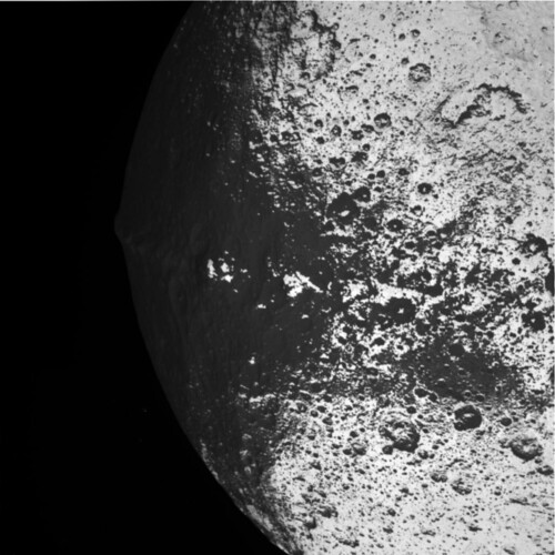
After "a solid state power switch that was tripped due to a galactic cosmic ray hit", the Cassini-Huygens spacecraft went into safe mode earlier this week. It’s recovered since and the fly-by was very cool:


NASA’s JPL got a nice surprise, according to the AP via MSNBC, from Sir Arthur:

Mission controllers have since sent commands for Cassini to resume normal transmission, and scientists recovered all the data from the moon flyby despite a nearly 12-hour delay. The spacecraft was expected to be fully functional by week’s end.

Iapetus, the third-largest Saturnian moon, gained science fiction fame in Clarke’s mind-bending novel "2001: A Space Odyssey," that was developed in concert with Stanley Kubrick’s 1968 movie by the same name.

Clarke, who lives in Sri Lanka, surprised the Cassini team with a five-minute video played Tuesday during an internal meeting at NASA’s Jet Propulsion Laboratory. In it, Clarke told scientists he looked forward to viewing photos from the flyby.

Even before Clarke’s taped greeting, scientists waxed poetic about Cassini’s encounter with Iapetus and the fictional Discovery spaceship’s rendezvous with Japetus, as the Saturn moon is known in Clarke’s book.

We don’t have the video to show you, but we do have the transcript, via Emily Lakdawalla at Planetary Society:

Video greeting to NASA JPL to mark the Iapetus flyby of Cassini spacecraft: 10 September 2007

by Arthur C. Clarke


Hello! This is Arthur Clarke, joining you from my home in Colombo, Sri Lanka.

I’m delighted to be part of this event to mark Cassini’s flyby of Iapetus.

I send my greetings to all my friends – known and unknown – who are gathered for this important occasion.

I only wish I could be with you in person, but I’m now completely wheelchaired by Polio and have no plans to leave Sri Lanka again.

Thanks to the World Wide Web, I have been following the progress of Cassini-Huygens mission from the time it was launched several years ago. As you know, I have more than a passing interest in Saturn…

And I was really spooked in early 2005, when the Huygens probe returned sound recordings from the surface of Titan. This is exactly what I had described in my 1975 novel Imperial Earth, where my character is listening to the winds blowing over the desert plains overhead.

That was perhaps just a foretaste of things to come! On September 10, if everything goes according to plan, Cassini would give us our closest look at Iapetus – one of Saturn’s most interesting moons.

Half of Iapetus appears as dark as asphalt, and the other half is as bright as snow. When Giovanni Cassini discovered Iapetus in 1671, he could only see its bright side. We had a better glimpse when Voyager 2 flew past in August 1981 – but that was from almost a million kilometres away.

In contrast, Cassini is going to come within a little over one thousand kilometres of Iapetus.

This is a particularly exciting moment for fans of 2001: A Space Odyssey – because that’s where the lone astronaut Dave Bowman discovers the Saturn monolith, which turns out to be a gateway to the stars. Chapter 35 in the novel is titled ‘The Eye of Iapetus’, and it contains this passage:
"Iapetus was approaching so slowly that it scarcely seemed to move, and it was impossible to tell the exact moment when it made the subtle change from an astronomical body to a landscape, only fifty miles below. The faithful verniers gave their last spurts of thrust, then closed down forever. The ship was in its final orbit, completing a revolution every three hours at a mere eight hundred miles an hour – all the speed that was required in this feeble gravitation field."

After more than 40 years, I cannot remember why I placed the Saturn monolith on Iapetus. At that time, in the early days of the Space Age, earth-based telescopes couldn’t show much details of this celestial body. But I have always had a strange fascination for Saturn and its family of Moons. By the way, that ‘family’ has been growing at a very impressive rate. When Cassini was launched, we knew of 18 moons. I understand it is now 60 – and counting…I just can’t resist the temptation to say:

My God, it’s full of moons!

But in the movie, Stanley Kubrick decided to place all the actions at Jupiter, not Saturn. Why this change? Well, for one thing it made a more straightforward storyline. And more importantly, the special effects department couldn’t produce a Saturn that Stanley found convincing.

That was just as well…because if they had done so, the movie would have been badly dated by the Voyager missions, which showed Saturn’s rings to be far more implausible than anyone had ever imagined.

I have seen enough instances where Nature imitates art, so I’m going to keep my fingers crossed on what Cassini discovers at Iapetus.

I want to thank everyone associated with this mission and the overall Cassini-Huygens project. It may lack the glamour of manned spaceflight, but science projects are tremendously important for our understanding of the Solar System. And who knows, one day our survival on Earth might depend on what we discover out there…

This is Arthur Clarke, wishing you a successful flyby.

Images from Cassini-Huygens are continuously updated.