Archive for 2006

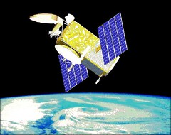
Sirius to Add Fourth, Geostationary Satellite

Friday, June 9th, 2006

Is Sirius looking to expand its product offerings? That’s the question that lingers between the lines in yesterday’s news reports that Sirius has agreed to a $260 million contract with Space Systems/Loral to launch a fourth satellite:

 Loral Space & Communications Ltd.’s (LORL) Space Systems/Loral unit, which built Sirius’s three existing in-orbit satellites and a fourth back-up satellite in storage, is constructing the new satellite – the FM-5. It is slated for completion in the fourth quarter of 2008. Once completed, the satellite will be launched on a Proton rocket under an existing contract with International Launch Service.

Sirius said the new satellite will help enhance overall coverage, particularly for stationary applications at home or in the office. Unlike the company’s current satellites, which travel in a figure-eight pattern above and below the equator that is known as an "elliptical geosynchronous orbit," the FM-5 will stay in a fixed position above the earth – a "geostationary orbit." Sirius said having a satellite in the different orbit will complement existing coverage. Rival XM Satellite Radio Inc. (XMSR) has all of its satellites in geostationary orbits.

With this new satellite, Sirius and XM will have the same number of satellites. XM is currently building a fourth satellite that is expected to launch in the second half of the year. It also has a spare under construction that is scheduled to be completed by the end of 2007.

A good explanation of how Sirius’ current satellite system works can be found here. Bell Labs did some work for Sirius (see here), and the question on analysts’ minds is whether the new geosynchronous satellite signals (no pun intended) an intention by Sirius to move into the market of providing video as well as radio to cars and buses. 

Time will tell. 


Launch-a-Rama!

Thursday, June 8th, 2006

Five– count ’em, five— satellite launches are set to take place from Baikonur Cosmodrome over a two week period this month.

As always, we’ll bring you more coverage as the birds get ready to fly. 

Scientists Sky-High Over First CloudSat Images

Thursday, June 8th, 2006

Last month we wrote about the launch of the CloudSat and Calipso satellites. Now reports are coming back that the first images from Cloudsat are giving scientists a completely new view of the clouds:


"We’re seeing the atmosphere as we’ve never seen it before," says Deborah Vane, CloudSat deputy principal investigator at NASA’s Jet Propulsion Laboratory in Pasadena, California, US. "We’re no longer looking at clouds like images on a flat piece of paper, but instead we’re peering into the clouds and seeing their layered complexity…."

CloudSat’s Cloud Profiling Radar, the first millimetre-wavelength radar, underwent tests in late May and was formally activated on 2 June.

"All major cloud system types were observed, and the radar demonstrated its ability to penetrate through almost all but the heaviest rainfall," says Graeme Stephens, CloudSat principal investigator and atmospheric scientist at Colorado State University, US.

The first image is a cross-section of a warm storm front above the Norwegian Sea taken on 20 May. In the image, red represents highly reflective particles such as raindrops, ice crystals or snowflakes. Blue represents thinner cirrus clouds.

The radar also provided a look at a night snow storm near Antarctica. The long winter nights make traditional remote sensing difficult in the polar regions and CloudSat is the first satellite able to detect snowfall from space.

A third image shows tall thunderstorm clouds over east Africa.

The results are still preliminary, but the mission team aims to release validated science data within nine months.

CloudSat is part of the A-Train, a constellation of five satellites that fly right behind one another, measuring the same swath of Earth.

The picture above is "CloudSat’s first image, of a warm front storm over the Norwegian Sea, was obtained on May 20, 2006. In this horizontal cross-section of clouds, warm air is seen rising over colder air as the satellite travels from right to left. The red colors are indicative of highly reflective particles such as water droplets (or rain) or larger ice crystals (or snow), while the blue indicates thinner clouds (such as cirrus). The flat green/blue lines across the bottom represent the ground signal. The vertical scale on the CloudSat Cloud Profiling Radar image is approximately 30 kilometers (19 miles). The blue line below the Cloud Profiling Radar image indicates that the data were taken over water."

For more information on Cloudsat, visit the NASA CloudSat website.

Flavor of the Month: AppleBerry?

Wednesday, June 7th, 2006

" Is the day near when you will get music on your BlackBerry and e-mail on your iPod?"

That’s the question swirling around the blogosphere after the Globe and Mail published a report this weekend claiming that senior executives at Intel have recommended that Research in Motion, Ltd. — makers of the uniquitous Blackberry — team up with Apple to work on a new product.  

The rumors began when analyst Peter Misek — who last year predicted the Intel/RIM collaboration– speculated on the partnership and argued that, in the least, the idea looks good on paper

Stan Beer over at ITWire shoots the whole thing down: 

One thing I do know, however, is that Apple is a hardware company that likes to control its own hardware. Another thing I know is that just three weeks ago we ran a substantiated story on this very site that outlined details of Apple working on its own iPod 3G mobile phone with Japanese company Softbank. As the story relates, Softbank president, Masayoshi Son and Apple CEO, Steve Jobs have met and reached an agreement to release a 3G iPhone for the Japanese market sometime in 2006.

The idea of Apple bringing its own iPod mobile phone to market appears to be more in line with the company’s culture than forming a joint venture with another hardware company that plays in a totally different market space. Apple is a company that does not like to share its brand and it likes to develop its own technology. Neither of those two philosophies appears to fit a Blackberry partnership.

What do you think? Is there an AppleBerry in your future? Or is the idea just another Ipod urban myth, like the Ipod that fell to Earth?

Jason-2 in Space

Tuesday, June 6th, 2006

It has nothing to do with Wes Craven and is not nearly as scary as it sounds: new details have been released about the Jason-2 (Joint Altimetry Satellite Oceanography Network) satellite set to be launched from Vandenberg AFB in October 2008. In a demonstration of international cooperation in global warming research, the Japan Aerospace Exploration Agency is working with the French company CNES on the project:

The science objectives of Jason-2/OSTM are to extend the time series of ocean surface topography measurements to: a) obtain a continuous record of observations (with the previous missions), b) to determine the variability of ocean circulation at decadal time scales from combined data record with T/P and Jason, c) improve the measure of the time-averaged ocean circulation, d) improve the measure of global sea-level change, and e) improve open ocean tide models.

The mission objectives call for the provision of the same measurement accuracy of Jason (3.3 cm) with a goal of achieving 2.5 cm, and to maintain the stability of the global mean sea level measurement with a drift less than 1 mm/year over the life of the mission. The overall goal is to better understand the forces behind global changes of climate and to predict seasonal anomalies in weather patterns; this is vital to understand the physics of the ocean.

Jason-2 is scheduled to join Jason-1 in the same orbit with a 10 day repeat observation cycle. Both satellites will pass within minutes of each other over the same ocean surface, thus enabling verification and cross-calibration of the collected data. Together, they will provide a vital contribution to the expanding network of global ocean observations and their application in meteorology, operational oceanography and climate monitoring.


Jovian Storms Forecast for Fourth of July

Monday, June 5th, 2006

Forget hurricane season. The really big storms to watch this summer are out of this world.

Specifically, they’re on Jupiter, where the Great Red Spot– a massive, centuries-old storm of 350 mph winds that is twice as big as the Earth — and Oval BA, aka "Red Jr.," — a six-year-old storm that is "only" the size of one Measly earth — are expected to brush against each other on or about the Fourth of July. Fireworks may fly, Space.com reports:

 "There won’t be a head-on collision," [says Amy Simon-Miller, an astronomer at Goddard Space Flight Center in Maryland.] "The Great Red Spot is not going to ‘eat’ Oval BA or anything like that."

However, the storms’ outer bands are expected to pass close to one another and it’s anybody’s guess what will happen when they do.

This isn’t the first time that such an encounter has happened. In fact, the two storms typically pass each other every two years or so. Similar encounters happened in 2002 and 2004, but they were very anti-climactic. Aside from some "roughing" around the edges, both storms came out unscathed.

This time might be different, however, said Simon-Miller. Red Jr. could revert to its original color and change from red to white. From 2000 to 2005, Red Jr. was actually white and no different form the many other small "white ovals" circling the planet.

But in 2006, astronomers noticed a change: a red vortex formed inside the storm, the same color as the powerful Great Red Spot. Scientists believe the color change was a sign that the storm was intensifying.

Scientists think the Great Red Spot could push Oval BA toward a southern jet stream on the planet during their upcoming encounter. The jet stream blows against Oval BA’s counterclockwise rotation and could slow its spin, possibly changing the storm’s color back to white.

The color of the Great Red Spot itself is a mystery. According to one popular theory, the storm dredges up material from deep inside Jupiter’s atmosphere, lofting it above the highest clouds where ultraviolet rays from the Sun turn color-changing compounds, called "chromophores," red.


WiFi in the Sky

Monday, June 5th, 2006

I have to confess, one of the things I like most about traveling for business is that it usually means a long period of time during which I’m unreachable. The mobile phone is shut off, and I don’t have internet access so I can’t answer email. I’m free to take a nap or read a book while I’m in the air.

Well, no more. JetBlue is moving to do away with my mile-high refuge by making wi-fi internet available in-flight

P11, jetblue tails

JetBlue Airways Corp. won a government auction Friday for wireless spectrum that could be used to provide in-flight telephone, Internet, or entertainment services.

The winning bid of $7.02 million was placed through New York-based JetBlue’s entertainment subsidiary, LiveTV LLC, which provides DirecTV service on JetBlue flights.

The licenses will not mean travelers can use their cell phones in the air, but between instant messaging and the avilability of free Skype calls in the U.S. and Canada, who needs to use their movile phone in-flight.

Flying Robots to Patrol Europe?

Monday, June 5th, 2006

Remember those flying robots we told you about earlier, and how Europe has some of their own. Well, now EU plans on putting those airborne bots to work

uav

Fleets of unmanned "drone" aircraft fitted with powerful cameras are to be used to patrol Europe’s borders in a dramatic move to combat people-smuggling, illegal immigration and terrorism.

The Independent on Sunday can today reveal that the tiny planes will fly at more than 2,500 feet over the English Channel and Mediterranean beaches as part of a £1bn programme to equip Europe’s police forces, customs officers and border patrols with hi-tech surveillance and anti-terrorism equipment.

The aircraft, called unmanned aerial vehicles (UAVs), are already being used by the Belgian government to catch tankers illegally dumping oil in the North Sea. Several ships’ captains have already been prosecuted.

The European Commission now wants to use similar drones, which can have a 6-metre wing-span and weigh as little as 195kg, to patrol the Mediterranean coasts and the Balkans where illegal immigrants try to enter the EU. The Russian government is also close to flying drones over its borders.

Interesting news, but if you ask me they’ll only really be on to something when the put tentacles on those flying robots.

Spacewalk Success

Friday, June 2nd, 2006

Looks like the spacewalk we blogged about yesterday went off without a hitch. Almost.

ISS SpacwalkThe spacewalk took 6 1/2-hours, longer than expected, but nowhere near the record of eight hours and 56 minutes set in 2001.

"OK. We’re going out," Russian commander Pavel Vinogradov said at 6:48 p.m. EDT Thursday as he and U.S. flight engineer Jeff Williams exited the Russian side of the station in their bulky suits while the outpost soared more than 220 miles above Earth.

Vinogradov attached himself to the end of a boom that can extend to 50 feet and Williams maneuvered him to an area on the station where the Russian commander installed a new vent for a broken oxygen-generation system. At one point, the spacewalkers were bathed in a golden glow from a sunset over the Pacific Ocean. After the sun passed, the temperature got chilly.

"My feet are like ice," Williams joked in Russian when asked if he was cold. A Russian flight controller responded, "We need to put brandy into the system instead of water." 

No word on the brandy, but there was a pretty cool droid on board the ISS.

Google Goes Green

Friday, June 2nd, 2006

More interesting uses for Google Maps — the site that brought satellite imagery to your desktop — keep cropping up.

Google Goes GreenGoogle has launched its first mashup–a map-based Web site with information about earth-friendly locations in five of the U.S.’s top travel destinations.

The site, at maps.google.com/green, features information on and video tours of spots in San Francisco, Los Angeles, Las Vegas, New York and Orlando, Fla., as well as tips for "traveling green" during the summer using Google Maps. 

… Listings include the Las Vegas Natural History Museum and the Go Raw Cafe in Las Vegas, the Tree People park and EcoLimo in Los Angeles, the Skyscraper Museum and Central Park in New York, the Forever Florida nature preserve and Horse World Riding Stables in Orlando and, in San Francisco the Red Victorian Bed and Breakfast and the Exploratorium.

But I think my favorite is a non-official mashup called Placeopedia, which matches WikiPedia articles with their locations. You can add a place, or spend click around to various places, which is a great time-waster or way to take a vacation without leaving your desk.