The Human Footprint

Here’s a question. When a major natural disaster strikes — for example, in Myanmar (Burma) earlier this year — how does the world figure out how many people are affected?

Here’s the answer: they ask SEDAC — NASA’s Socioeconomic Data and Applications Center  — which works with GRUMP.

 

No, not that GRUMP; the Global Rural-Urban Mapping Project (GRUMP) provides estimates of the population of the world and population densities, which are then overlayed with other scientific data to provide detailed maps of everything from ecosystem assessments to — wait for it — the global poultry density.

And, of course, the number of people affected when disaster strikes: 

“The gridded population product we produce helps officials understand the density of the population in and around a disaster area,” said Robert Chen, manager of NASA’s Socioeconomic Data and Applications Center (SEDAC) and director of the Center for International Earth Science Information Network (CIESIN), part of the Earth Institute at Columbia University in New York. “The data set shows where people actually live in relationship to hazardous events….

SEDAC, a part of NASA’s Earth Observing System Data and Information System, collects, stores, processes and distributes population, land use, and socioeconomic data. A significant mission of NASA’s Earth-observing satellite program is to enable scientists and other users to conduct analyses and make decisions based on the resulting data. SEDAC advances this mission by developing and operating practical applications that merge social science and Earth science data to improve knowledge of how humans interact with Earth’s environment.

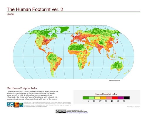
The dataset produced by GRUMP is fascinating. Think you live in a crowded area? Take a look at India and China. SEDAC has also produced an amazing series of maps showing the "human footprint" on the world, which can be viewed here.
 

Also be sure to check out CIESIN’s maps showing the global distribution of vulnerability to climate change

Debi Decides Satellite Radio Merger


Deborah Taylor Tate is the FCC commissioner who will cast the deciding vote to approve the Sirius/XM merger, via the Wall Street Journal:

Republican commissioner Deborah Taylor Tate is the only FCC member left to vote on the deal and she is expected to do so shortly, two FCC officials close to the negotiations said. She is expected to sign off on the deal in exchange for a consent decree that resolves several enforcement issues involving the satellite radio companies and a combined fine of about $20 million, an FCC source close to the deal said.

Ms. Tate has also asked for a variety of other minor conditions, an FCC source said. An adviser to Ms. Tate did not respond to a call for comment. Exact details about the deal are not known since FCC officials and lawyers for the companies appear to still be working them out.

Ms. Tate’s vote would finally end the agency’s 13-month review of the deal. Her vote is critical for the deal’s approval since the rest of the five-member board remained evenly split on the deal.

As of Wednesday morning, both of the FCC’s two Democratic commissioners had voted against the deal. Democrat Jonathan Adelstein announced his decision in a statement, noting he was hoping for a "bipartisan solution" but that the other commissioners weren’t interested.

Last week, Mr. Adelstein proposed conditions including a six-year price cap, a 25% channel set-aside for non-commercial and minority-owned stations and interoperable radios that would receive high-definition signals from terrestrial radio stations.

FCC chairman Kevin Martin had made it clear to the rest of the commissioners Tuesday evening that Mr. Adelstein’s conditions would not be a focus of the negotiations, an agency source said.

In recent days, Ms. Tate has been the center of negotiations, as the companies have wrangled over how to resolve several outstanding enforcement issues that have been raised. They include issues involving complaints that some of the satellite radio receivers exceeded FCC power limits and bled into the signals of some local radio stations.

Concerns have also been raised that Sirius has yet to bring to market an interoperable radio despite an FCC requirement that it develop one. Broadcasters have also complained that satellite booster towers were placed in nonapproved locations.

The Russians Are Coming


Yes, that’s the title from a memorable 1966 movie, a comedy. That’s also the title of an Agence France-Presse bulletin issued earlier today that begins with "The Russian are coming…"

The Guiana Space Centre (CSG) is girding for a new era when it will host Russian rockets and Russian engineers who just a short while ago were Europe’s space rivals.

For 40 years, this base on the coast of French Guiana was the prestigious symbol of French, and then European, ambitions in space.

On Sunday, a freighter is due to dock in Cayenne bearing a first consignment of 150 containers of equipment to fit out a launch pad at CSG where, from the second half of 2009, the first "European" Soyuz is scheduled to blast into space.

Nothing funny about the space business — very serious business indeed. This might be the beginning of greater cooperation in space, especially the business side. Launching commercial spacecraft is big business, costing anywhere from $80 to $100 million or more for heavy-lift launches. Satcom operators need access to reliable launch service providers, and if they could increase capacity.


The Russians are coming — to chessboxing, too. "Chessboxing?" That’s right: it’s a new sport. Brains and brawn. Just like the rocket launch business.


Here’s the CNN report…


And one from Ukrainian television…

Olympics VOD

The 2008 Olympics in Beijing is right around the corner and, despite the political controversy, one thing is clear: this year’s games will be easier to watch than ever before.

It’s all because of VOD: Video-on-Demand.

NBCU is producing lots of VOD, which will be available via DIRECTV.

NBCU is providing DIRECTV with 10 VOD titles each week, including athlete features, Beijing previews, and more. The service will be available through the end of the Olympics in both standard-definition and HD. NBCU will produce more than 500 titles now through the end of the 2008 Beijing Olympic Games.

The VOD offerings are just part of NBCU’s extensive coverage of the games, which will also be available on FiOS, Broadband, and Verizon’s V CAST mobile service.

For those who prefer to watch online, NBCU’s website will give fans access to approximately 2,200 total hours of live streaming and video coverage of 25 different sports. The site will also feature blogs, live chat, athlete profiles and, of course, the latest results.

The servers and platform for the groundbreaking digital content will be provided by Sun Microsystems.

If you want to psych yourself up for some amazing sports action in Beijing, search YouTube for some great moments in Olympics history. Take, for example, the 1968 Olympics in Mexico City where Bob Beamon set a new world record in the long jump that stood for 23 years.

English language version here.

Predicting Space Weather

On reading that title, you might be asking yourself “why in the world would I need to predict space weather?” Well, I’ll tell you. Space weather – the range of high-energy radiation, such as X-rays and gamma rays, that constantly bombard the Earth’s atmosphere – affects the performance of some of your favorite gadgets, like GPS and satellite TV.

With this camera, scientists can predict changes is space weather, allowing for communications companies to compensate for electromagnetic interruptions to their signals. Never again will your Planet of the Apes marathon be spoiled by a bad signal. Oh, and it’ll help the military predict and plan for interruptions in their communications too.

The project – the Global-Scale Observations of the Limb and Disk – is known by a catchy acronym: GOLD.

The GOLD Camera will fly on an SES AMERICOM satellite. Physicist Richard Eastes, who leads the GOLD project, says this is the first time that a NASA instrument has flown on a commercial communications satellite.

This is the second “hosted” payload for an AMERICOM spacecraft just this month. The other was for the Air Force’s CHIRP (Commercially Hosted Infrared Payload).

DIY Friday: Solar Death Ray

It’s another lazy, hot summer weekend…what to do to pass the time?

Crochet a new bathing suit? Nah.

Make a beaded pull for the ceiling fan? No thanks.

Craft some sunglasses out of popsicle sticks and tinted saran wrap? Maybe next week.

I’m looking for something a bit more bold to shake up the summer doldrums: A SOLAR DEATH RAY.

You may have seen the “#1 solar death ray on the Internet” here. But that model was so 2006.

Yes, the competitive world of solar death ray construction has moved well beyond that.

This guy, inspired by the success of the original, bought himself a c-band antenna and made a device capable of generating 13,000 watts. He calls it the “light sharpener” and you can find full instructions on his site to make your own.

The only question is, to what end will you direct the power of your very own light sharpener? The answer, clearly, is remaking the classic American cook-out.


Of course, Really Rocket Science was ahead of the curve on this one…but we have to admit that his is bigger.

GPS Beats Speeding Ticket


Rocky Mountain Tracking‘s device is accurate. So good, in fact, it beat a police radar in court:

Eighteen-year-old Shaun Malone has a few people to thank for being able to plead "Not Guilty" to a speeding offence – his parents, who installed a GPS device in his car, and Rocky Mountain Tracking, the service provider of that device.
 
"Because of our GPS tracking data, Malone and his parents can protest the imposition of an unfair speeding ticket," says Brad Borst, Founder and President of Rocky Mountain Tracking, and who is also a former Police Officer.

A police radar had found Malone driving at 62 mph in a 45-mph zone. However, Malone’s parents, who had installed the Rocky Mountain Tracking GPS device in his car to monitor his driving, found that the device tracked him driving at, and not above, the speed limit.

The most telling testament to the accuracy of the Rocky Mountain Tracking Rover GPS tracking device came, ironically, from a GPS expert who originally helped find Malone guilty in a trial-by-affidavit. Dr. Stephen Heppe, the expert, had written a report affirming that, going by the GPS data, Malone had to have been traveling faster than 45 mph.

Read their blog for more detail. And Hot Hardware gets more from the expert:

While the police clocked him going 62-mph, the GPS’s data in fact showed him driving at the 45-mph speed limit. In an initial trial-by-affidavit, Malone was found guilty of speeding. GPS expert, Dr. Stephen Heppe wrote a report that essentially said that the GPS data was not accurate enough to contest the accuracy of the radar gun. Malone appealed the decision and had his day in court. At trial, things played out differently:

"However, when he took the stand to begin his testimony, Dr. Heppe corrected that written report, saying that the Rocky Mountain Tracking device was "very" accurate, to within a couple of meters on location and to within 1 mph on speed. Dr. Heppe also pointed out that the GPS device released instantaneous data, and not data averaged over a distance."

Needless to say, with Dr. Heppe’s revised testimony, Malone was found innocent of speeding.


Teenagers. Some learn about the danger of speeding the hard way, some know better before they start driving. Check out this kid in Kentucky:

Landon Wilburn, 11, grew tired of speeders zipping through his subdivision, so after growing hoarse shouting at them, he decided to take matters into his own hands.

The youngster, who used to shout at speeders to slow down as they drove through the Stone Lakes subdivision in Louisville, now has taken matters into his own hands.

Dressed in a reflective vest, wearing a bicycle helmet and armed with an orange Hot Wheels brand radar gun, he points and records the actual speed of passing traffic.

Landon also carries a flashlight with a built-in siren.

"When I saw it happening, I got the biggest kick out of it," said resident George Ayers, 61. "People were locking up their brakes when they saw him."


You can hack these toy radar guns, or you could really have some fun as-is.

SOCOM: Moving With Satcom


Carl von Clausewitz once famously observed that war is the extension of politics by other means.

So it seems fitting, at least in the sense that truisms are true, that the satcom-on-the-go platform that has been bringing the American people live coverage of the presidential election (which we blogged about here) is now being used by U.S. Special Forces in the Middle East.

We’re speaking, of course, of the ArcLight Mobile Satellite Communication System by ViaSat. We’ve written before about how the broadcast networks use the system in moving vehicles, and how the same platform is being used by AMERICOM and KVH for maritime mobile broadband

Now comes a press release announcing that ViaSat Airborne Broadband Ku-band satcom is being deployed by U.S. Special Forces for real time data and video communications: 

The system is already in use in the Middle East and coverage areas will expand as more terminals and hubs are delivered. This new operational capability, an extension of the ArcLight® mobile broadband system, is installed on C-130 aircraft, primarily for sending high resolution video back to higher command authorities for further analysis and identification.

Here’s a video of the type of real-world situations that the ArcLight system can help commanders in-field and at the United States Special Operations Command address. It’s taken from an AC-130 Gunship observing insurgents in Iraq. (Warning: Video contains violence and may not be suitable for all viewers.)


 The C-130 satcom system is built around the advanced ArcLight modem and networking technology using a spread spectrum waveform to enable the use of mobile satellite antennas as small as 29 centimeters in diameter. The antenna is enclosed in a radome attached to a redesigned emergency escape hatch. In a few minutes, operators can configure an aircraft for their specific mission without any permanent aircraft alterations, then quickly return the aircraft to its normal configuration when the mission is complete, while maintaining safety-of-flight integrity. The U.S. Air Force-certified hatch-mount terminal enables secure access to Department of Defense wide area networks at raw data rates up to 10 Mbps inbound and 512 kbps outbound while airborne.

Russian Hide-N-Seek


As Mark Twain said, "Always tell the truth. That way, you don’t have to remember what you said." The Russian Defence Ministry’s Information and Public Relations Directorate ought to make a note of it.

Back in April, Red Orbit reported they denied a major satellite malfunction:

"In connection with reports published in some mass media alleging that the Kosmos-2421 satellite has disintegrated, we would like to report that its planned flight programme has been fulfilled. After switching off its on-board equipment, the satellite was taken out of service in accordance with the established procedure", reads the directorate’s report received by Interfax-AVN today.

According to the Defence Ministry, "the Kosmos-2421 satellite remains in its orbit, the parameters of which correspond to the predicted ones, and is under steady observation by means of the national system of space control".

The ministry added that there are three more space objects in orbits close to Kosmos-2421. "One of them is a stage vehicle of a carrier rocket, and the other two – fragments of a launch [vehicle]", the report says. [Passage omitted on "a NASA website" report on the alleged disintegration of the satellite; background]

Originally published by Interfax-AVN military news agency website, Moscow, in Russian 1431 15 Apr 08.

Well, according to NASA’s Orbital Debris Quarterly News, that’s not entirely true:

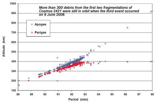
Late in the first quarter of 2008, the U.S. Space Surveillance Network (SSN) detected a significant fragmentation of Cosmos 2421 (International Designator 2006-026A, U.S. Satellite Number 29247), which produced approximately 300 detectable debris (see ODQN, Vol. 12, Issue 2). Two more fragmentation events of the same spacecraft during April-June added another 200 or more large debris (greater than 5 cm) to the near-Earth space environment, once again raising questions about the peculiar nature of this satellite class.


You can count on our friends at U.S. Strategic Command’s Space Surveillance Network to keep an eye on them.


EchoStar XI Launch Update

Set for tonight at 10:21pm PST via Sea Launch:

Long Beach, Calif., July 14, 2008 – The Sea Launch team arrived at the launch site in the Equatorial Pacific over the weekend and initiated a 72-hour countdown, in preparation for the launch of the EchoStar XI satellite on Tuesday, July 15. Liftoff is planned at 10:21pm PDT, July 15 (5:21 GMT, July 16), at the opening of a two-hour launch window.

Upon arrival at the launch site, at 154 degrees West Longitude, the team ballasted the Odyssey Launch Platform to launch depth. A final series of tests on all systems is now underway. Prior to fueling operations, the platform will be evacuated, with all personnel safely positioned on the ship, about four miles from the platform. One hour after liftoff, a Zenit-3SL vehicle will insert the 5,511 kg (12,150 lb) EchoStar XI satellite into geosynchronous transfer orbit, on its way to a final orbital location of 110 degrees West Longitude.

Built by Space Systems/Loral (SS/L), the powerful 20-kW spacecraft, carries a Ku-band payload that will support DISH Network’s direct broadcast television service for its customers throughout the United States. This spacecraft is designed for a 15-year service life on orbit. This is the 3rd mission Sea Launch is executing for DISH Network and the 8th mission with a spacecraft built by SS/L.

Check out a live still webcam from the platform here and here. If you’re going to stay up late, you can watch live coverage of the launch here. And Sea Launch has extensive coverage of the mission and satellite here.

With DISH Network promising 130 HD channels by the end of 2008, this satellite launch is, like all of them, very important. And this launch couldn’t be mre timely, as DISH just surpassed 100 channels just a few days ago. And this means that DISH may have just surpassed DirecTV.