DIY Friday: Steampunk Satellite Dish


We’ve done featured quite a few DIY projects that recycle or re-use old satellite antennas. From using an old Primestar reflector to improve WiFi, to the wireless Internet cantenna, to more physical structures such as this BUD gazebo and the ever-popular solar cooker. Not mention one for the birds.

Today, you’re on your own with the steampunk satellite dish. We’re inspired by work commissioned by Telstra in Australia and created by Martin Dolan and the mArty Gallery, near Melbourne.


Look around your shop for old pipe and things parabolic, and have at it!

Australia. Steampunk. I’m thinking Mad Max, aren’t you?


50 Years of Tracking Weather From Space


Nice piece in today’s Star-Ledger, marking the 50th anniversary of the TIROS spacecraft, designed and built by RCA Astro-Electronics in East Windsor, NJ:

WALL — It didn’t get the respect of Sputnik or a hit song like Telstar, but 50 years ago today TIROS redefined the space race.

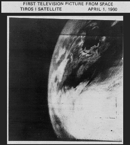
For the 78 days it functioned, this engineering marvel proved America could not only put a satellite into outer space but — in a giant leap beyond the Soviet satellites — take pictures once it got there.

"It was huge. Massive. It not only did radically change the study of meteorology, but it gave us the upper hand in the Cold War by showing the Russians we could spy on them from outer space," said historian Fred Carl. "How cool is that?"

Way cool. And impossible without New Jersey’s contribution, which may be why the state appears to be the only place celebrating TIROS’s big anniversary, according to NASA officials.
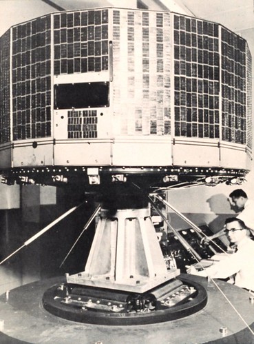
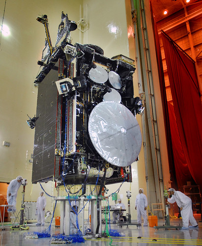
TIROS-satellite2.jpgPhoto by Carolyn Russo/NASMIn 1960, TIROS I became the world’s first successful imaging weather satellite. Nine more TIROS series spacecraft followed, and they revolutionized weather monitoring and prediction. This prototype of TIROS I and II was used for ground testing.
Granted, the festivities are not exactly on par with Columbus Day.

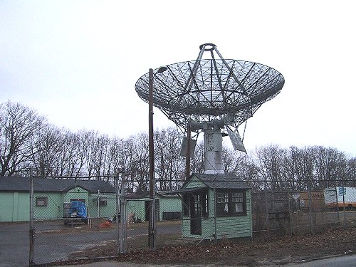
In Princeton, the party will start Saturday with a program featuring some of the scientists who worked at RCA Astro-Electronics in East Windsor, the birthplace of TIROS. In Wall Township, home of the giant dish that received the first images sent back from TIROS, local officials will gather April 11 to sign an application to put the site on the National Historic Register.

In coming weeks there will be scholarly discussions about the future of space exploration and a dinner dance.

Primarily, however, the TIROS anniversary is an opportunity for aging scientists and engineers to reflect back on when they were there for the dawn of space travel.

"It was a time of national need and TIROS is about how one group of people responded to that need," said George Martch, 73, a retired RCA engineer who is organizing the Princeton celebration. "It’s hard now, when satellite photos are everywhere, to imagine what it was like back then before the technology existed.

"We were making it up as we went along."

Only 40 years earlier, meteorologists were still sending up kites to get weather readings, a practice that routinely caused electrocution. But World War II brought huge technological advances. By the 1950s, the basics were there.

Cameras had already gone briefly into space, attached on the backs of ballistic missiles. The military had put test satellites into brief orbit and NASA, the civilian space agency, was in place, although in its infancy.

The problem was putting it all together.

"What we had was mostly experimental. We had to adapt cameras and find a way to store images, since they could only be sent back under certain conditions," said Martch, adding they also developed a power source, antennas and a way to stabilize the orbit. "You have to remember, there really was no aerospace before this."

It was a time of flux, as systems, structural and electrical engineers, scientists, physicists, and experts in thermal dynamics and propulsion were switched back and forth, depending on the progress of each component, RCA retirees recalled.

There was drama along the way. They learned electronics will fry when subjected to the wrong pressure in a vacuum chamber. There were heated theoretical battles and even romance among two RCA scientists who later married.

The result looked like a giant hatbox and weighed less than a defensive lineman. It was aluminum and stainless steel and covered with 9,200 solar cells.

Launched April 1, 1960, out of Cape Canerval Florida, it stayed in orbit by spinning like a top, traveled 18,000 mph and could circle the earth every 90 minutes at an altitude of about 450 miles.

It was formally known as the Television Infra-Red Observation Satellite and shot 22,962 photographs before a fatal power failure ended its mission.

TIROS was the first satellite to publicly take photos of the earth, although there was a secret project launched by the U.S. military a year earlier. However, only TIROS could send photos back to Earth in real time.

The "Eye in the Sky," as TIROS was also called, needed a way to phone home, and that is where Camp Evans in Monmouth County came in.

The former property of telegraph pioneer Marconi had been absorbed by RCA. It was later sold to the military and the Signal Corps built a radar laboratory there during World War II, said Carl, a former science teacher who is leading a campaign to preserve the site.

A giant receiver that was assembled at Camp Evans, where it still exists. Minutes after TIROS sent back its first picture, it was on a jet to Washington and hand-delivered to President Eisenhower. He sent copies to the Russians and the Chinese as a "gesture of goodwill," noting TIROS busily was taking photos of both countries.

Kicking a little Communist butt at the height of the Cold War was only a side benefit of TIROS. Its real accomplishment came nine days into orbit, when it sent back a photograph of a curious cloud formation with a hole in the middle.

Planes were dispatched to the photo location, in one of the "silent spots" in the South Atlantic where it was formerly impossible to take weather readings. The "hole" was a nascent tropical storm.

Hurricane tracking was born.

"Solar cells, tape recorders, transistor tubes, phone cameras. They all are directly related to TIROS," said Carl. "But with storm tracking, TIROS is responsible for saving millions of lives, yet few people have ever heard of it. Don’t you think it’s time that changed?

The back-up can be found at the Smithsonian’s National Air and Space Museum in Washington, D.C.

The tracking antenna on Marconi Road in Wall, N.J.? Still working…


Our friends at NOAA are marking the anniversary as well…

Fifty years ago today, the world’s first weather satellite lifted off from Cape Canaveral, Fla., and opened a new and exciting dimension in weather forecasting. Top leaders from NOAA and NASA hailed the milestone as an example of their agencies’ strong partnership and commitment to flying the best satellites today and beyond.

The first image from the satellite, known as TIROS-1 (Television Infrared Observation Satellite), was a fuzzy picture of thick bands and clusters of clouds over the United States. An image captured a few days later revealed a typhoon about a 1,000 miles east of Australia. TIROS-1, a polar-orbiting satellite, weighed 270 pounds and carried two cameras and two video recorders. Though the satellite only lasted 78 days, its impact is still visible today.

“This satellite forever changed weather forecasting,” said Jane Lubchenco, Ph.D., under secretary of commerce for oceans and atmosphere and NOAA administrator. “Since TIROS-1, meteorologists have far greater information about severe weather and can issue more accurate forecasts and warnings that save lives and protect property.”

"TIROS-1 started the satellite observations and interagency collaborations that produced vast improvements in weather forecasts," said NASA Administrator Charles F. Bolden, Jr. "It also laid the foundation for our current global view of Earth that underlies all of climate research and the field of Earth system science."

Throughout the 1960s, each TIROS spacecraft carried increasingly advanced instruments and technology. By 1965, meteorologists combined 450 TIROS images into the first global view of the world’s weather.




SES To Acquire Eutelsat


In a EUR13 billion deal that’s been brewing for years, Luxembourg-based SES (NYSE Euronext Paris and Luxembourg Stock Exchange: SESG) is acquiring Paris-based Eutelsat (NYSE Euronext Paris: ETL) to preserve its EBITDA of 80%. The deal was announced after the SES Annual General Meeting, and may be approved as early as next week in Annecy. The deal is more than twice Eutelsat’s market cap.

SES aims to be the employer of choice in the industry. The company identifies, secures, engages, develops and retains the best talent to further expand its technological reach and business objectives. With this acquisition, we have struck our target and will thus be the only employer in the industry — at least in Europe.

As a result of the merger, the satellite fleet will be renamed HOT ASS and shall henceforth be abbreviated as  "HA." The combined companies’ 2,200-headcount is expected to remain the same.

No pesky DoJ or DoD review is requited, and the EU Competition Directorate is expected to approve the acquisition by the end of April…

Ceci est une bonne idée! Competition Policy is basically applying rules to make sure that companies compete with each other and, in order to sell their products, innovate and offer good prices to consumers. How can we not approve such an ingenious deal? Enough of this senseless rivalry. The EU wants better prices for all and full employment in the satellite business.

Meanwhile, the agreement with Yahsat for a DTH service in the Middle East is expected to benefit from hundreds of new "adult" channels and will be renamed YAH BABY!


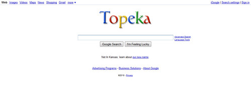
 Happy April Fool’s Day. Yeah, we’ll come up with something better next year. Google’s name change to Topeka wins. Brilliant.


WBMSAT Satellite Industry News Bits 03/26/2010

Satellites use in U.S. FCC’s broadband plan a big unknown.
[Aviation Week – 03/26/2010]

DirecTV may lose stations in fight over retransmission-consent fees.
[Contact Music – 03/26/2010]

Alliant Techsystems and Lockheed partner to develop smaller less expensive launch vehicles for smaller satellites.
[Wall Street Journal – 03/26/2010]

The 50th Ariane 5 was rolled out March 25 for March 26 launch with a mixed civilian and military telecommunications satellite payload.
[SatNews – 03/25/2010]

ViaSat receives approximately $21.5 million order for Multifunctional Information Distribution System – Low Volume Terminals (MIDS-LVT) from the Space and Naval Warfare Systems Command (SPAWAR), MIDS Program Office (MPO).
[SatNews – 03/25/2010]

Comtech EF Data wins $2.5 million order for satellite communications equipment for new satellite network of an Asian Pacific enterprise.
[TMCnet – 03/25/2010]

EchoStar Europe secures the ‘Best Hybrid Broadcast-IP Video Delivery Solution or Service’ award at the IPTV World Series Awards in London.
[SatNews – 03/25/2010]

Comtech AeroAstro is awarded $39.7 million contract to develop and deliver spacecraft bus to U.S. Navy for the Joint Milli-Arcsecond Pathfinder Survey mission.
[Market Watch – 03/25/2010]

Eutelsat welcomes launch of UK Space Agency and government recognition of satellite broadband for bridgint the "Digital Divide."
[RealWire – 03/25/2010]

Secure World Foundation has released a budget analysis that examines an array of U.S. Department of Defense (DoD) space security programs as outlined in its Fiscal Year 2011 budget request.
[SatNews – 03/25/2010]

Measat-3a will distribute Discovery HD channel in Asia.
[Satellite Today – 03/25/2010]

KVH opens subsidiary based in Singapore to support growing demand for KVH’s miniVSAT satellite broadband and TracVision satellite TV services.
[The Maritime Executive – 03/25/2010]

Satcom Direct receives FAA certification for Inmarsat Satellite Communications Training Course to count toward requirements for Inspection Authorization renewal.
[SatNews – 03/25/2010]

European Union foreign ministers call on Iran to cease censorship and jamming of satellite broadcasts coming from Europe.
[Satellite Today – 03/25/2010]

KVH and Viasat receive authorization to operate the mini-VSAT service in the Indian Ocean region.
[SatNews – 03/25/2010]

Comtech EF Data receives $1 million order to provide C-band satellite communications equipment to a U.S. government agency.
[TMCnet – 03/24/2010]

High-level panel of space leaders and economic experts will meet in Colorado Springs to address impact on the overall information infrastructure and financial climate as the space industry becomes more international and more diversified.
[SatNews – 03/24/2010]

Sea&Space Exploration, a Brussels-based consulting company, and Global VSAT Forum release report at Satellite 2010 stating that global consumber and enterprise demand for satellite communications has strong potential to exceed historical trends.
[Satellite Today – 03/24/2010]

Hughes Network Systems and Vizada reach agreement expanding Hughes Europe’s portfolio of managed network services for European enterprises.
[SatNews – 03/24/2010]

Air Force to add high-speed satellite communications link to Global Hawk UAV.
[Military & Aerospace – 03/24/2010]

Innovative Solutions & Support announce receipt of FAA Supplemental Type Certificate for the Class 3 Electronic Charts and XM Satellite Weather upgrade to cockpit system of Eclipse Aerospace EA500 Very Light Jet.
[SatNews – 03/24/2010]

Twentieth Century Fox and SmartJob sign non-exclusive agreement for satellite distribution of digital cinema content to theatres in Europe.
[SatNews – 03/24/2010]

Spacecom, Israeli operator of AMOS satellite fleet, is selected by  Germany’s Da Vinci Media GmbH to distribut Da Vinci Learning Channel in Eastern and Central Europe.
[SatNews – 03/24/2010]

Canadian broadcaster’s get leverage  under new framework laid out by the Canadian Radio-television and Telecommunications Commission to allow blockage of cable and satellite re-broadcast of local channels in absence of compensation.
[Montreal Gazette – 03/23/2010]

Comtech EF Data wins the World Teleport Association’s Teleport Technology of the Year award for its CDM-625 Advance Satellite Modem.
[CNN Money – 03/23/2010]

ORBCOMM launches web-based subscriber portal at CTIA Wireless 2010.
[PR Newswire – 03/23/2010]


Satellite communications set up for Abu Dhabi motor rally.
[Thaindian News – 03/23/2010]

Sierra Wireless and ORBCOMM announce new M2M portal that gives ORBCOMM’s customers ability to seamlessly track and manage equipment worldwide, even over ocean.
[SatNews – 03/23/2010]

EchoStar plans Dish Network market expansions in North America.
[Satellite Today – 03/23/2010

Surrey Satellite Technology welcomes British government program including launch of the UK’s first national space agency.
[SatNews – 03/23/2010]

SkyTerra stockholders approver merger with Harbinger Capital Partners.
[Satellite Today – 03/23/2010]

Thales Alenia Spaces negotiates with European Space Agency for contract to build Meteosat Third Generation satellites.
[Satellite Today – 03/23/2010]

Thrane & Thrane SwiftBroadband receives Inmarsat type approval and parts manufacturer approval from U.S. FAA.
[Satellite Today – 03/23/2010]

RapidEye enters reseller partnership with Harris.
[Satellite Today – 03/23/2010]

SatMAX announces record-breaking number of inquiries about its non-line of sight satellite equipment following second purchase order from U.S. Navy.
[TMCnet – 03/22/2010]

TerreStar to highlight satellite capability in standard mobile devices at CTIA Wireless 2010.
[Market Watch – 03/22/2010]

Higher bandwidth availability and networking requirements in Military Satellite Communications (MilSatCom) create new opportunities for advanced electronic components.
[Business Wire – 03/22/2010]

Eutelsat Communications has revealed it will be upgrading its satellite broadband service Tooway to offer download speeds of ‘up to’ 10Mbps by the end of 2010.
[Network World – 03/22/2010]

Bankruptcy court approves second round of financing for Sea Launch.
[Satellite Today – 03/22/2010]

Intelsat signes agreement with Turkish operator Turksat to provide satellite capacity serving Middle East region.
[Satellite Today – 03/22/2010]

Eutelsat Communications announces the successful completion of the UK-built communications module for its high-speed broadband communications satellite, KA-SAT.
[SatNews – 03/21/2010]

London-based environmental campaigner travelling world in biofuel-driven bus runs into legal trouble in India for using a satellite phone in the country.
[Simple Thoughts – 03/21/2010]

Leaders from 5 largest MSS companies debate form and function of mobile satellite industry at Satellite 2010, and praise the U.S. FCC’s broadband plan.
[Satellite Today Satellite 2010 – March 2010]

OverHorizon has selected Arianespaace to launch into orbit their OHO-1 satellite.
{SatNews – 03/21/2010]

WBMSAT PS – Satellite Communications Consulting Services

More TV at 119 West


 Nice going/launching by ILS in Baikonur the other day, bringing relief to the folks at Space Systems/Loral — and lots more HDTV capacity for DISH Network customers. Aviation Week gives us the update…

A commercial Proton orbited the heaviest satellite ever to fly on the Russian launch vehicle March 21, placing the 6.3-metric-ton EchoStar XIV Ku-band satellite in its geosynchronous transfer orbit for the DISH Network.

The launch vehicle’s Breeze M upper stage released the spacecraft after a nine-hour, 10-minute mission. Liftoff from Pad 39 at the Baikonur Cosmodrome in Kazakhstan came at 2:27 p.m. EDT.

The launch was the second arranged this year by International Launch Services, and the fourth Proton launch of the year.

The spacecraft was built by Space Systems/Loral based on its 1300 satellite bus.

It will be positioned at 119 deg. W. Long., where it will deliver Ku-band service over the U.S. for the DISH Network’s high-definition programming.

And the mandatory video…


Sugarloaf Science


Time for a little vacation — in Sugarloaf, Maine.

The weather may seem discouraging, but there’s no substitute for being here. Rain mixed with snow and sleet. The mountain’s completely open, with 130+ trails. 

I like their Web cam…


As The X-Band Sees It


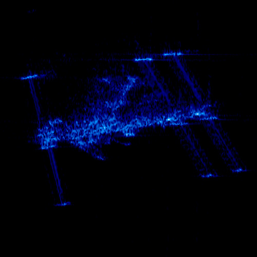
 What the International Space Station looks like in the X-band, via The Planetary Society

 On March 13, 2008, the International Space Station (ISS) passed across the field of view of Germany’s remote sensing satellite, TerraSAR-X, at a distance of 195 kilometers.

In contrast to optical cameras, radar does not "see" surfaces. Instead, it is much more sensitive to the edges and corners which bounce back the microwave signal it transmits. Unless they are directly facing the radar spacecraft, smooth surfaces such as those on the ISS solar and radiator panels, do not reflect a strong signal to the detector, so they appear dark. Yet the bright spots outlining edges and corners clearly show the shape of the ISS. The central element on the ISS, to which all the modules are docked, has a grid structure that presents a multiplicity of reflecting surfaces to the radar beam, making it readily identifiable. This image has a resolution of about one meter.

Credit: German Aerospace Center (DLR)

Major Satcom, Ready to Ship


“This reflects the Air Force’s strong commitment to providing superior protected satellite communications capabilities for the war fighter.” That’s what Steve Tatum wrote in response to the news of the USAF’s pending request for $6.5 billion to get the Advanced EHF program into space. The first one launched in September:

The Air Force said it will request four years of funds totaling $6.5 billion for a Lockheed Martin Corp. military communications program that plans to launch its first satellite in September after six years of delays.

The funding request for fiscal years 2012-2015 will follow $598 million sought for fiscal 2011, according to an e-mail from Gary Payton, the Air Force’s top civilian for space programs. The six-satellite program is budgeted at a total of $9.9 billion.

The request, part of the Pentagon’s current five-year budget plan, reflects the Air Force moving forward with a program endorsed by Defense Secretary Robert Gates now that delays and technical problems have been worked out.

Bethesda, Maryland-based Lockheed Martin and its top subcontractor, Los Angeles-based Northrop Grumman Corp., have been awarded contracts to build the first three satellites. They may get contracts for a fourth that the Air Force budgeted for next year and two more planned by 2014. The Air Force budget figures show that the service may buy a seventh satellite starting in fiscal 2015.

The Advanced EHF program calls for six satellites, capable of withstanding shocks from a nuclear attack, to allow secure communications between top commanders including the president. It also would provide transmission of tactical communications such as real-time video, battlefield maps and targeting data.


Good day at the office for Lockheed Martin (and subcontractor Northrup Grumman). How "advanced" is this system? Dude.

The B-2 is being upgraded, using fiber connections — inside the aircraft.  A single AEHF spacecraft will provide more capacity than the entire Milstar system currently on-orbit — combined.

Watch this…


FAIL: Satmex Bondholders


The deal to buy Satmex is off. What seemed like a brilliant acquisition by all accounts, will not go through.

EchoStar Corp. and MVS Comunicaciones SA ended their agreement to buy Satelites Mexicanos SA for $267 million after the Mexican satellite operator’s bondholders objected to the deal.

Satmex, as the company is known, failed to get approval from holders of a majority of bonds within the 17 days allotted under the agreement, EchoStar said Tuesday in a U.S. regulatory filing.

El Economista suggests they’re holding out for a minimum of $500 million. Not sure it’s such a good idea to wait. If Satmex-5 fails, how much would the company be worth then? I say cash out now while you still can.

The Mexican government owns 20% of the company, so it would be interested to get their take on this.


Outdoors at the Satellite Show


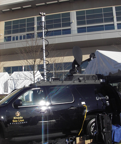
This Mini outfitted with a mobile antenna is pretty cool, although it may not be as practical as the "command vehicle" put together by CAMMS.

CAMMS™ (Command Anywhere Media Management System) was developed to enable a totally secure, scalable mobile mesh (ad hoc) network and provide the necessary tools for Command Anywhere.

The CAMMS™ mobile mesh software program is a patent pending Windows-based program, which provides the foundation for an ad hoc, self-forming / self-healing wireless mobile mesh network.   It provides interoperability and allows real time communications with any others users in the mesh.

Mobile mesh (ad hoc) networks offer many advantages over other types of communications networks.  Chief among these is the ability of the mesh to function independently of a land-based infrastructure.

When communication is linked solely to a land-based infrastructure an acute vulnerability exists.  By utilizing a mesh, the network infrastructure becomes decentralized, avoiding a central point of failure and control.  Command can be located anywhere with hand off from first responder to others when required instantly.

The CAMMS™ mobile mesh software does not require servers or fixed access points (FAP’s) and is compatible with existing mesh AP’s.  The software may be purchased separately to maximize existing communications systems or as part of complete interoperable communications solution that includes software and AP.