50 Years of Tracking Weather From Space
Nice piece in today’s Star-Ledger, marking the 50th anniversary of the TIROS spacecraft, designed and built by RCA Astro-Electronics in East Windsor, NJ:
WALL — It didn’t get the respect of Sputnik or a hit song like Telstar, but 50 years ago today TIROS redefined the space race.
For the 78 days it functioned, this engineering marvel proved America could not only put a satellite into outer space but — in a giant leap beyond the Soviet satellites — take pictures once it got there.
"It was huge. Massive. It not only did radically change the study of meteorology, but it gave us the upper hand in the Cold War by showing the Russians we could spy on them from outer space," said historian Fred Carl. "How cool is that?"
Way cool. And impossible without New Jersey’s contribution, which may be why the state appears to be the only place celebrating TIROS’s big anniversary, according to NASA officials.
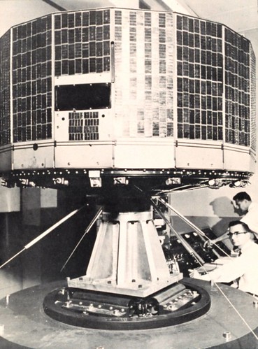
TIROS-satellite2.jpgPhoto by Carolyn Russo/NASMIn 1960, TIROS I became the world’s first successful imaging weather satellite. Nine more TIROS series spacecraft followed, and they revolutionized weather monitoring and prediction. This prototype of TIROS I and II was used for ground testing.
Granted, the festivities are not exactly on par with Columbus Day.In Princeton, the party will start Saturday with a program featuring some of the scientists who worked at RCA Astro-Electronics in East Windsor, the birthplace of TIROS. In Wall Township, home of the giant dish that received the first images sent back from TIROS, local officials will gather April 11 to sign an application to put the site on the National Historic Register.
In coming weeks there will be scholarly discussions about the future of space exploration and a dinner dance.
Primarily, however, the TIROS anniversary is an opportunity for aging scientists and engineers to reflect back on when they were there for the dawn of space travel.
"It was a time of national need and TIROS is about how one group of people responded to that need," said George Martch, 73, a retired RCA engineer who is organizing the Princeton celebration. "It’s hard now, when satellite photos are everywhere, to imagine what it was like back then before the technology existed.
"We were making it up as we went along."
Only 40 years earlier, meteorologists were still sending up kites to get weather readings, a practice that routinely caused electrocution. But World War II brought huge technological advances. By the 1950s, the basics were there.
Cameras had already gone briefly into space, attached on the backs of ballistic missiles. The military had put test satellites into brief orbit and NASA, the civilian space agency, was in place, although in its infancy.
The problem was putting it all together.
"What we had was mostly experimental. We had to adapt cameras and find a way to store images, since they could only be sent back under certain conditions," said Martch, adding they also developed a power source, antennas and a way to stabilize the orbit. "You have to remember, there really was no aerospace before this."
It was a time of flux, as systems, structural and electrical engineers, scientists, physicists, and experts in thermal dynamics and propulsion were switched back and forth, depending on the progress of each component, RCA retirees recalled.
There was drama along the way. They learned electronics will fry when subjected to the wrong pressure in a vacuum chamber. There were heated theoretical battles and even romance among two RCA scientists who later married.
The result looked like a giant hatbox and weighed less than a defensive lineman. It was aluminum and stainless steel and covered with 9,200 solar cells.
Launched April 1, 1960, out of Cape Canerval Florida, it stayed in orbit by spinning like a top, traveled 18,000 mph and could circle the earth every 90 minutes at an altitude of about 450 miles.
It was formally known as the Television Infra-Red Observation Satellite and shot 22,962 photographs before a fatal power failure ended its mission.
TIROS was the first satellite to publicly take photos of the earth, although there was a secret project launched by the U.S. military a year earlier. However, only TIROS could send photos back to Earth in real time.
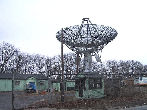
The "Eye in the Sky," as TIROS was also called, needed a way to phone home, and that is where Camp Evans in Monmouth County came in.
The former property of telegraph pioneer Marconi had been absorbed by RCA. It was later sold to the military and the Signal Corps built a radar laboratory there during World War II, said Carl, a former science teacher who is leading a campaign to preserve the site.
A giant receiver that was assembled at Camp Evans, where it still exists. Minutes after TIROS sent back its first picture, it was on a jet to Washington and hand-delivered to President Eisenhower. He sent copies to the Russians and the Chinese as a "gesture of goodwill," noting TIROS busily was taking photos of both countries.
Kicking a little Communist butt at the height of the Cold War was only a side benefit of TIROS. Its real accomplishment came nine days into orbit, when it sent back a photograph of a curious cloud formation with a hole in the middle.
Planes were dispatched to the photo location, in one of the "silent spots" in the South Atlantic where it was formerly impossible to take weather readings. The "hole" was a nascent tropical storm.
Hurricane tracking was born.
"Solar cells, tape recorders, transistor tubes, phone cameras. They all are directly related to TIROS," said Carl. "But with storm tracking, TIROS is responsible for saving millions of lives, yet few people have ever heard of it. Don’t you think it’s time that changed?
The back-up can be found at the Smithsonian’s National Air and Space Museum in Washington, D.C.
The tracking antenna on Marconi Road in Wall, N.J.? Still working…
Our friends at NOAA are marking the anniversary as well…
Fifty years ago today, the world’s first weather satellite lifted off from Cape Canaveral, Fla., and opened a new and exciting dimension in weather forecasting. Top leaders from NOAA and NASA hailed the milestone as an example of their agencies’ strong partnership and commitment to flying the best satellites today and beyond.
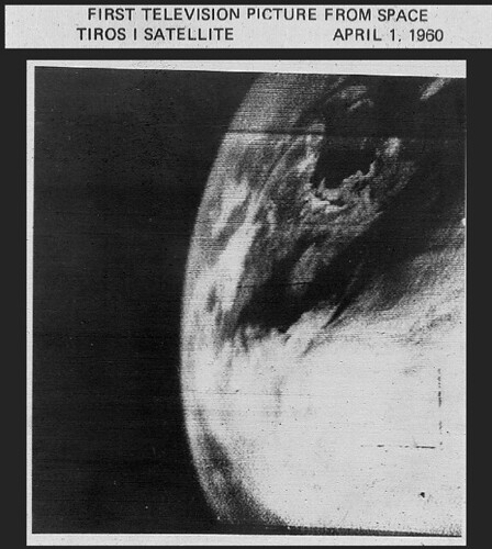
The first image from the satellite, known as TIROS-1 (Television Infrared Observation Satellite), was a fuzzy picture of thick bands and clusters of clouds over the United States. An image captured a few days later revealed a typhoon about a 1,000 miles east of Australia. TIROS-1, a polar-orbiting satellite, weighed 270 pounds and carried two cameras and two video recorders. Though the satellite only lasted 78 days, its impact is still visible today.
“This satellite forever changed weather forecasting,” said Jane Lubchenco, Ph.D., under secretary of commerce for oceans and atmosphere and NOAA administrator. “Since TIROS-1, meteorologists have far greater information about severe weather and can issue more accurate forecasts and warnings that save lives and protect property.”
"TIROS-1 started the satellite observations and interagency collaborations that produced vast improvements in weather forecasts," said NASA Administrator Charles F. Bolden, Jr. "It also laid the foundation for our current global view of Earth that underlies all of climate research and the field of Earth system science."
Throughout the 1960s, each TIROS spacecraft carried increasingly advanced instruments and technology. By 1965, meteorologists combined 450 TIROS images into the first global view of the world’s weather.
Although not strictly weather related,rogue waves also known as freak waves are towering and spontaneous ocean waves that are born far out at sea, and are a threat even to large ships.In oceanography, they are usually defined as waves whose height is more than twice the significant wave height (SWH), This measurement is dependant on observing a series of waves to determine the largest third of waves. Therefore rogue waves are not necessarily the largest waves found at sea; they are, surprisingly, large waves for a given sea state.